|
Crich
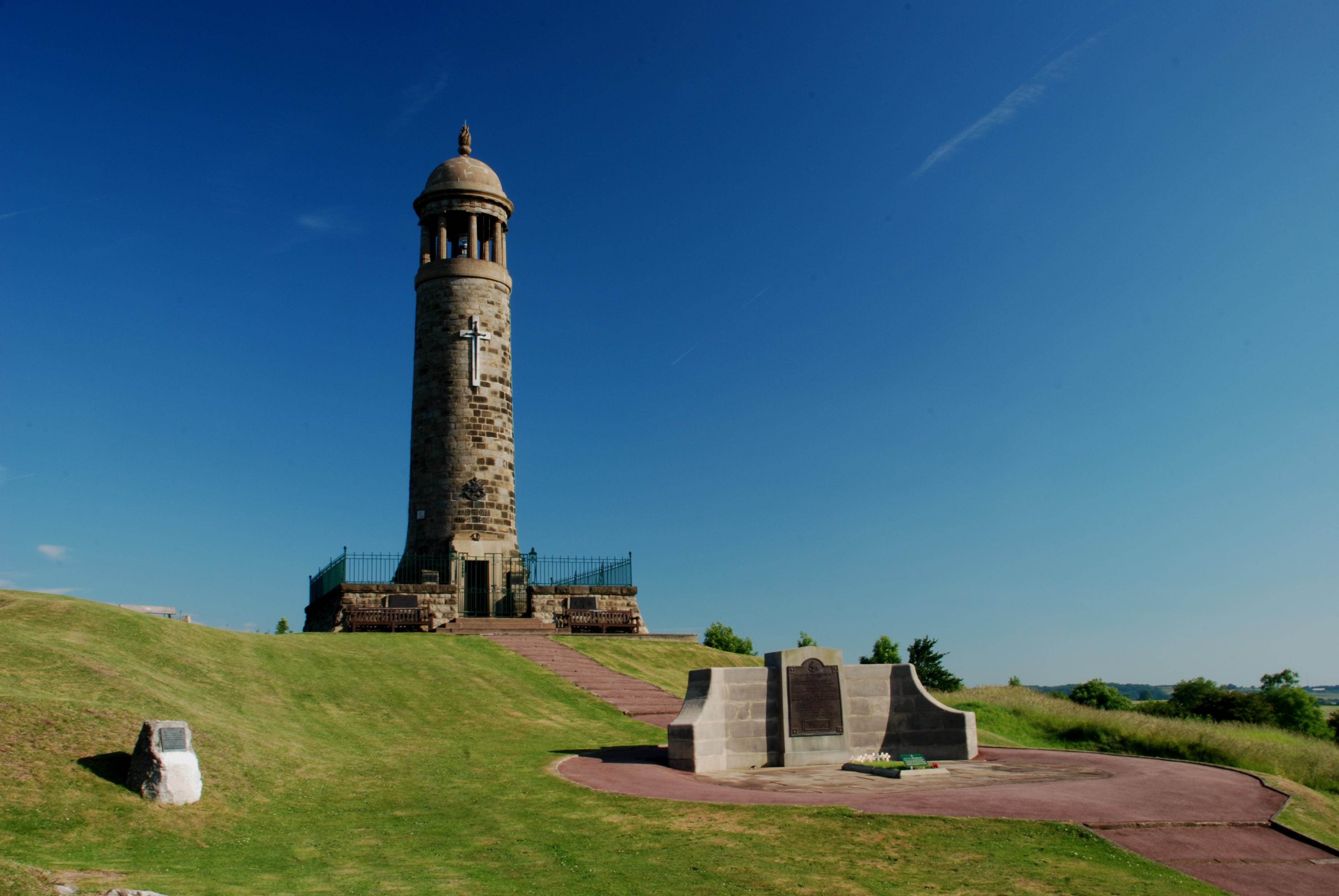
Crich is a village and civil parish in the English county of Derbyshire. Besides the village of Crich, the civil parish includes the nearby villages of Fritchley, Whatstandwell and Wheatcroft, Derbyshire, Wheatcroft. The population of the civil parish at the 2001 census was 2,821, increasing to 2,898 at the 2011 census. The village is home to the National Tramway Museum and, at the summit of Crich Hill above, a memorial tower for those of the Sherwood Foresters regiment who died in battle, particularly in World War I. History In 1009 King Æthelred the Unready signed a charter at the Great Council which recognised the position and boundaries of Weston-on-Trent and several other manors including Crich. The charter shows that Weston controlled the nearby crossings of the Trent. The land was listed as eight Hide (unit), hides at Weston upon Trent, and a hide at Crich, Morley, Derbyshire, Morley, Smalley, Derbyshire, Smalley, Ingleby, Derbyshire, Ingleby and Kidsley. This land ... [...More Info...] [...Related Items...] OR: [Wikipedia] [Google] [Baidu] |
National Tramway Museum
The National Tramway Museum, operating under the name Crich Tramway Village, is a transport museum located at Crich (), in the Peak District of the English county of Derbyshire. The museum's collection of trams is officially designated as being of national importance and encompasses the 1860s to the present day. The museum is set within a reconstructed historic village, featuring a traditional public house, café, period-style sweetshop, and a tram depot. Many of the trams are fully operational and provide rides for visitors along a scenic route that runs through the village and into the surrounding countryside. The museum is operated by the Tramway Museum Society, a registered charity which receives no funding from local or central government and relies on admission charges and donations. History of the museum History of the site George Stephenson, the great railway pioneer, had a close connection with Crich and the present (2008) tramway follows part of the mineral railway he ... [...More Info...] [...Related Items...] OR: [Wikipedia] [Google] [Baidu] |
Sherwood Foresters
The Sherwood Foresters (Nottinghamshire and Derbyshire Regiment) was a line infantry regiment of the British Army in existence for just under 90 years, from 1881 to 1970. In 1970, the regiment was amalgamated with the Worcestershire Regiment to form the Worcestershire and Sherwood Foresters Regiment, which in 2007 was amalgamated with the Cheshire Regiment and the Staffordshire Regiment (Prince of Wales's) to form the present Mercian Regiment. The lineage of the Sherwood Foresters is now continued by The Mercian Regiment. History Pre 1914 history The regiment was formed on 1 July 1881 as part of the Childers Reforms. The 45th (Nottinghamshire) Regiment of Foot (raised in 1741) and the 95th (Derbyshire) Regiment of Foot (raised in 1823) were redesignated as the 1st and 2nd battalions of the Sherwood Foresters (Derbyshire Regiment). The Derbyshire Militia and Royal Sherwood Foresters Militia became the 3rd (Reserve) and 4th (Extra Reserve) battalions respectively. These were j ... [...More Info...] [...Related Items...] OR: [Wikipedia] [Google] [Baidu] |
Amber Valley
Amber Valley is a local government district with borough status in the east of Derbyshire, England, taking its name from the River Amber. Its council is based in Ripley. The district covers a semi-rural area lying to the north of the city of Derby. The district contains four main towns whose economy was based on coal mining and remains to some extent influenced by engineering, distribution and manufacturing, holding for instance the headquarters and production site of Thorntons confectionery. The House of Commons constituency of Amber Valley is of smaller scope. The village of Crich and other parts of the district were the setting for ITV drama series '' Peak Practice''. History The district was formed on 1 April 1974 under the Local Government Act 1972 as one of nine districts within Derbyshire. The new district covered the area of five former districts, which were all abolished at the same time: * Alfreton Urban District * Belper Rural District * Belper Urban District ... [...More Info...] [...Related Items...] OR: [Wikipedia] [Google] [Baidu] |
Derbyshire Dales (UK Parliament Constituency)
Derbyshire Dales ( ) is a List of United Kingdom Parliament constituencies, constituency that has been represented in the House of Commons of the United Kingdom, House of Commons of the Parliament of the United Kingdom, UK Parliament since 2024 by John Whitby of the Labour Party (UK), Labour Party. The constituency was created for the 2010 United Kingdom general election, 2010 general election. History Following their review of parliamentary representation in Derbyshire, the Boundary Commission for England created a new constituency of Derbyshire Dales which is almost coterminous with the previous seat of West Derbyshire (UK Parliament constituency), West Derbyshire. At the first four elections of its existence, it elected Conservative Party (UK), Conservative MPs by Safe seat, safe margins, with the 2024 United Kingdom general election, fifth such election seeing Labour Party (UK), Labour gain the seat for the first time since 1945. Constituency profile The constituency is geo ... [...More Info...] [...Related Items...] OR: [Wikipedia] [Google] [Baidu] |
Morcar (thegn)
Morcar (or Morkere) () (died 1015) was a thane (minister) of King Æthelred the Unready. He was given lands in Derbyshire in 1009, including Weston-on-Trent, Crich, and Smalley by King Æthelred in 1011 and 1012. He was also given the freedom from the three common burdens. He and his brother were executed in 1015. Morcar's brother's wife was later married to King Edmund Ironside. Biography Morcar was the son of Earngrim, according to John of Worcester, and his brother was Sigeferth. He was mentioned in the will of Wulfric Spot, brother of Ælfhelm and son of Wulfrun. In 1004, when Wulfric died, he made Morcar a major beneficiary, along with Burton Abbey and Ælfhelm. Morcar was a king's thegn (Latin ''minister'') in 1009 when King Æthelred the Unready issued a charter, in which he gave lands to his ''minister'' Morcar. The charter shows that he would control the crossings of the River Trent at Weston-on-Trent, Wilne, and King's Mills in Leicestershire. Although not men ... [...More Info...] [...Related Items...] OR: [Wikipedia] [Google] [Baidu] |
Fritchley
Fritchley is a small village in Derbyshire, England, situated to the south of Crich and north of Ambergate. It falls under the civil parish of Crich. To the east of the village is the ruin of a windmill. Fritchley has an active Congregational Church, and there is a Quaker meeting house with an active Quaker Meeting. There is a pub, the Red Lion, but the post office closed in 2009. The village hosts a steam rally each August. In 1793, Fritchley Tunnel, the world's oldest surviving railway tunnel was constructed under a public road here on the Butterley Gangroad, the Butterley Company's plateway to carry limestone from Hilt's Quarry at Crich to Lime kiln, kilns on the Cromford Canal at Bullbridge, by Benjamin Outram. The tunnel was scheduled under the Ancient Monuments and Archaeological Areas Act in February 2015. Fritchley was used as one of the filming locations for the hit UK TV series, Peak Practice, which ran from 1993 to 2002. [...More Info...] [...Related Items...] OR: [Wikipedia] [Google] [Baidu] |
Whatstandwell
Whatstandwell () is a village on the River Derwent, Derbyshire, River Derwent in the Amber Valley district of Derbyshire, England. It is about five miles south of Matlock, Derbyshire, Matlock and about four miles north of Belper. Whatstandwell railway station is on the Derby–Matlock Derwent Valley Line, and the A6 road (Great Britain)#Leicester–Peak District, A6 trunk road crosses the River Derwent in the village. Most of the population is included in the civil parish of Crich but the village may be said to extend across the Derwent into the parish of Alderwasley. History On Peter Perez Burdett's map of 1791, it is shown as 'Hottstandell Bridge', probably a literal spelling of the local dialect. A mid-19th-century Ordnance Survey map shows it as 'Whatstandwell Bridge' which was the name given to the railway station. The name derives from Walter Stonewell, who "held of the convent" the house next to the bridge which John de Strepul built at his own expense, in 1393. Geography ... [...More Info...] [...Related Items...] OR: [Wikipedia] [Google] [Baidu] |
Derbyshire
Derbyshire ( ) is a ceremonial county in the East Midlands of England. It borders Greater Manchester, West Yorkshire, and South Yorkshire to the north, Nottinghamshire to the east, Leicestershire to the south-east, Staffordshire to the south and west, and Cheshire to the west. Derby is the largest settlement, and Matlock is the county town. The county has an area of and a population of 1,053,316. The east of the county is more densely populated than the west, and contains the county's largest settlements: Derby (261,400), Chesterfield (88,483), and Swadlincote (45,000). For local government purposes Derbyshire comprises a non-metropolitan county, with eight districts, and the Derby unitary authority area. The East Midlands Combined County Authority includes Derbyshire County Council and Derby City Council. The north and centre of Derbyshire are hilly and contain the southern end of the Pennines, most of which are part of the Peak District National Park. They include Kinde ... [...More Info...] [...Related Items...] OR: [Wikipedia] [Google] [Baidu] |
Matlock, Derbyshire
Matlock is the county town of Derbyshire, England. It is in the south-eastern part of the Peak District, with the National Park directly to the west. The spa resort of Matlock Bath is immediately south of the town as well as Cromford lying further south still. The civil parish of Matlock Town had a population in the 2021 UK census of 10,000. Matlock is south-west of Chesterfield, Derbyshire, Chesterfield and in close reach of the cities of Derby (19 miles), Sheffield (20 miles) and Nottingham (29 miles). Matlock is within the Derbyshire Dales district and is the headquarters of Derbyshire County Council. History The name Matlock derives from the Old English ''mæthel'' (or ''mæðel''), meaning assembly or speech, and ''āc'', meaning oak tree; thus Matlock means 'moot-oak', an oak tree where meetings are held. In the Domesday Book of 1086 it was recorded as ''Meslach'' and in 1196 it was named ''Matlac''. It is a former spa town that lies on the River Derwent, Derbyshire, Ri ... [...More Info...] [...Related Items...] OR: [Wikipedia] [Google] [Baidu] |
Weston-on-Trent
Weston-on-Trent is a village and civil parish in the South Derbyshire district of Derbyshire. The population of the civil parish at the 2011 census was 1,239. It is to the north of the River Trent and the Trent and Mersey Canal. Nearby places include Aston-on-Trent, Barrow upon Trent, Castle Donington and Swarkestone. Toponymy The name is of Anglo-Saxon origin (-''ton'' being an Anglo-Saxon suffix meaning "town"). The name literally means 'West Town' – with Aston-on-Trent ('East Town') lying east of it. 'On-Trent' refers to the nearby River Trent. History Middle ages In 1009 Æþelræd Unræd (King Ethelred the Unready) signed a charter at the Great Council which recognised the position and boundaries of Weston. The charter shows that Weston controlled the crossings of the Trent at, Weston Cliff, King's Mills and Wilne. These crossings controlled one of the main routes for travellers moving up or down England and was a boundary within Mercia. The land was listed as eig ... [...More Info...] [...Related Items...] OR: [Wikipedia] [Google] [Baidu] |
Ingleby, Derbyshire
Ingleby is a hamlet and civil parish in the South Derbyshire district, in Derbyshire, England, situated to the south of the River Trent on a rise between Stanton by Bridge and Repton. In 2001 the parish had a population of 85. It is the location of Anchor Church,Derby City page on the Anchor Church a small series of caves in the sandstone which were the homes of s. The word Ingleby means 'Village of the English'.Tribes of Britain, David Miles, Phoenix Books, 2006, p215 Nearby places include , [...More Info...] [...Related Items...] OR: [Wikipedia] [Google] [Baidu] |
Wheatcroft, Derbyshire
Wheatcroft is a hamlet in the hills of Amber Valley, near Crich, Derbyshire Derbyshire ( ) is a ceremonial county in the East Midlands of England. It borders Greater Manchester, West Yorkshire, and South Yorkshire to the north, Nottinghamshire to the east, Leicestershire to the south-east, Staffordshire to the south a ..., England. Wheatcroft has no shop or church and while it once had a chapel it has been renovated into a small dwelling. References Hamlets in Derbyshire Geography of Amber Valley {{Derbyshire-geo-stub ... [...More Info...] [...Related Items...] OR: [Wikipedia] [Google] [Baidu] |


