|
Crescenta Valley
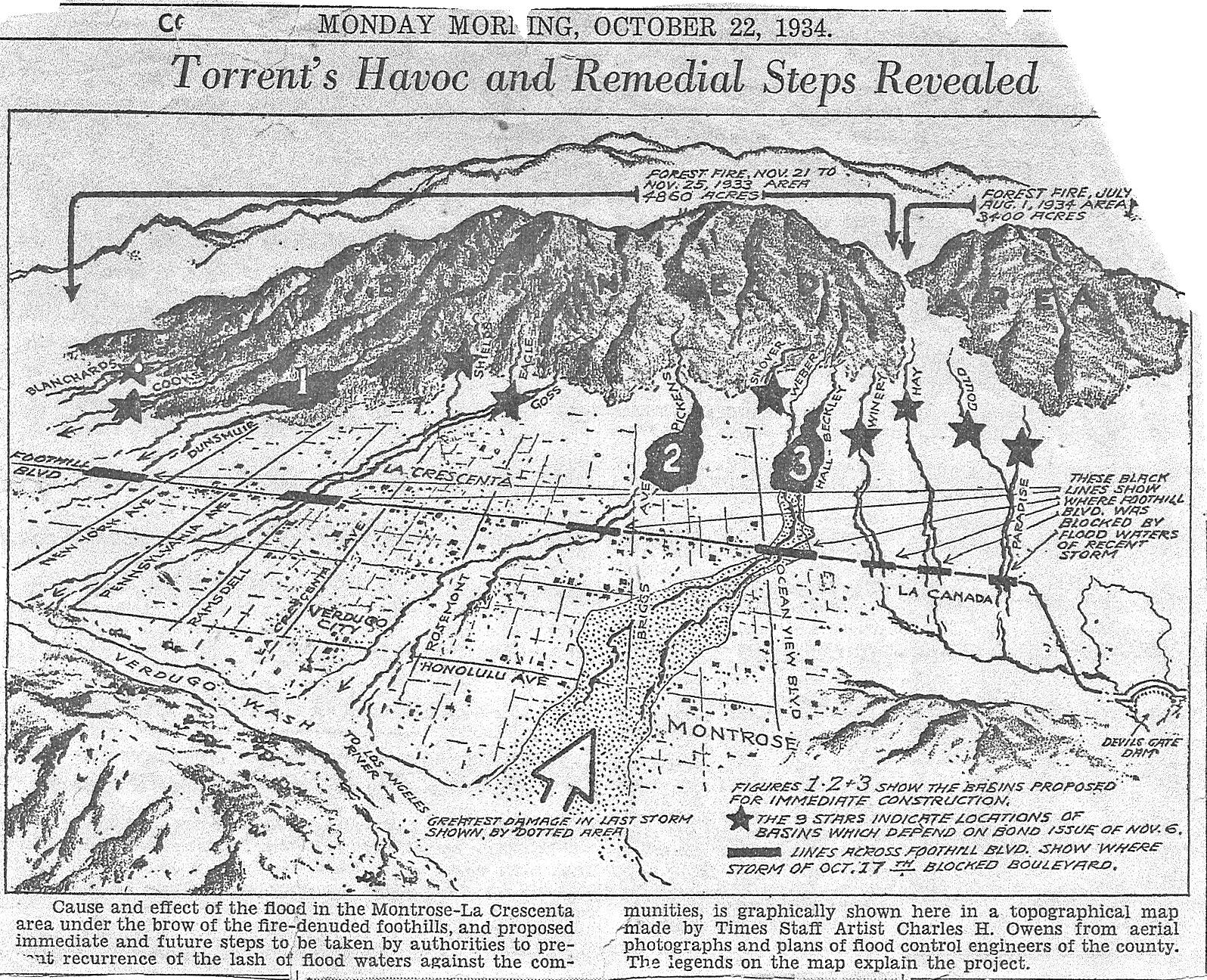
The Crescenta Valley is a small inland valley in Los Angeles County, California, lying between the San Gabriel Mountains on the northeast and the Verdugo Mountains and San Rafael Hills on the southwest. It opens into the San Fernando Valley at the northwest and the San Gabriel Valley at the southeast. It is nearly bisected by the Verdugo Wash, a smaller valley separating the Verdugo Mountains from the San Rafael Hills. Most of the valley lies at an elevation of over . Etymology The name "Crescenta" does not derive from the Spanish word for "crescent", which is ''el creciente''. Benjamin Briggs coined the name from the English word "crescent" because he could see three crescent-shaped formations from his home,Gudde, Erwin G. (1998). ''California Place Names: The Origin and Etymology of Current Geographic Names'', 4th ed. Berkeley: University of California Press. or because of the shape of the valley.Dougherty, June (1993). ''Sources of History: La Crescenta''. Privately printe ... [...More Info...] [...Related Items...] OR: [Wikipedia] [Google] [Baidu] |
Verdugo Mountains
The Verdugo Mountains, also known as the Verdugo Hills or simply The Verdugos, are a small, rugged mountain range of the Transverse Ranges system in Los Angeles County, California. Located just south of the western San Gabriel Mountains, the Verdugo Mountains region incorporates the cities of Burbank, Glendale, Pasadena, and La Cañada Flintridge; the unincorporated communities of Altadena and La Crescenta-Montrose; as well as the City of Los Angeles neighborhood of Sunland-Tujunga. It is where the borders of the San Gabriel Valley and the San Fernando Valley meet. Surrounded entirely by urban development, the Verdugo Mountains represent an isolated wildlife island and are in large part under public ownership in the form of undeveloped parkland. The mountains are used primarily for recreation in the form of hiking and mountain biking, and as the site of communications installations on the highest peaks. The mountains arise directly from the eastern floor of the San Fernand ... [...More Info...] [...Related Items...] OR: [Wikipedia] [Google] [Baidu] |
Oak Forest
An oak forest is a plant community with a tree canopy dominated by oaks (''Quercus spp.''). In terms of canopy closure, oak forests contain the most closed canopy, compared to oak savannas and oak woodlands. Setting Oak forests are categorized as deciduous forests which commonly have dense canopy cover (~70%) on dry soils with large amounts of undecomposed oak leaves over the ground. The forests are commonly found around the Appalachian Mountains and neighboring areas in the Midwest United States. Soils within the forests are highly acidic and dry with habitats existing in low elevation areas as well as large mountainsides, providing resources and an ecosystem for large amounts of common plant and animal species in those regions. Indicated by the large presence of oaks (''Quercus spp.''), the community is also dominated by inflammable shrubs and different vegetation commonly seen in oak savannas and oak woodlands. This plant life is often credited with assisting in maintain ... [...More Info...] [...Related Items...] OR: [Wikipedia] [Google] [Baidu] |
Tujunga, Los Angeles, California
Sunland-Tujunga is a Los Angeles city neighborhood within the Crescenta Valley and Verdugo Mountains. Sunland and Tujunga began as separate settlements and today are linked through a single police station, branch library, neighborhood council, chamber of commerce, city council district, and high school. The merging of these communities under a hyphenated name goes back as far as 1928. Sunland-Tujunga contains the highest point of the city, Mount Lukens. History Pre-colonial and Mexican eras Sunland and Tujunga were originally home to the Tongva people. In 1840, the area was part of the Rancho Tujunga Mexican land grant, but later developers marked off a plot of land known as the Tejunga Park, or the Tujunga Park Tract. The name "Tujunga" (or Tuxunga) is assumed to have meant "old woman's place" in the Fernandeño language, a dialect of the extinct Tongva language, where ''tuxu'', "old woman", is a term for Mother Earth in Tongva mythology. The term is thought to relate t ... [...More Info...] [...Related Items...] OR: [Wikipedia] [Google] [Baidu] |
La Cañada Flintridge
LA most frequently refers to Los Angeles, the second most populous city in the United States of America. La, LA, or L.A. may also refer to: Arts and entertainment Music *La (musical note), or A, the sixth note *"L.A.", a song by Elliott Smith on ''Figure 8'' (album) * ''L.A.'' (EP), by Teddy Thompson *''L.A. (Light Album)'', a Beach Boys album * "L.A." (Neil Young song), 1973 *The La's, an English rock band *L.A. Reid, a prominent music producer * Yung L.A., a rapper *Lady A, an American country music trio * "L.A." (Amy Macdonald song), 2007 *"La", a song by Australian-Israeli singer-songwriter Old Man River *''La'', a Les Gordon album Other media * l(a, a poem by E. E. Cummings * La (Tarzan), fictional queen of the lost city of Opar (Tarzan) *'' Lá'', later known as Lá Nua, an Irish language newspaper * La7, an Italian television channel *LucasArts, an American video game developer and publisher * Liber Annuus, academic journal Business, organizations, and government a ... [...More Info...] [...Related Items...] OR: [Wikipedia] [Google] [Baidu] |
Census-designated Place
A census-designated place (CDP) is a Place (United States Census Bureau), concentration of population defined by the United States Census Bureau for statistical purposes only. CDPs have been used in each decennial census since 1980 as the counterparts of incorporated places, such as self-governing city (United States), cities, town (United States), towns, and village (United States), villages, for the purposes of gathering and correlating statistical data. CDPs are populated areas that generally include one officially designated but currently unincorporated area, unincorporated community, for which the CDP is named, plus surrounding inhabited countryside of varying dimensions and, occasionally, other, smaller unincorporated communities as well. CDPs include small rural communities, Edge city, edge cities, colonia (United States), colonias located along the Mexico–United States border, and unincorporated resort and retirement community, retirement communities and their environs. ... [...More Info...] [...Related Items...] OR: [Wikipedia] [Google] [Baidu] |
Suburb
A suburb (more broadly suburban area) is an area within a metropolitan area. They are oftentimes where most of a metropolitan areas jobs are located with some being predominantly residential. They can either be denser or less densely populated than the city and can have a higher or lower rate of detached single family homes than the city as well. Suburbs can have their own political or legal jurisdictions, especially in the United States, but this is not always the case, especially in the United Kingdom, where most suburbs are located within the administrative boundaries of cities. In most English-speaking world, English-speaking countries, suburban areas are defined in contrast to core city, central city or inner city areas, but in Australian English and South African English, ''suburb'' has become largely synonymous with what is called a "neighborhood" in the U.S. Due in part to historical trends such as white flight, some suburbs in the United States have a higher population ... [...More Info...] [...Related Items...] OR: [Wikipedia] [Google] [Baidu] |
World War II
World War II or the Second World War (1 September 1939 – 2 September 1945) was a World war, global conflict between two coalitions: the Allies of World War II, Allies and the Axis powers. World War II by country, Nearly all of the world's countries participated, with many nations mobilising all resources in pursuit of total war. Tanks in World War II, Tanks and Air warfare of World War II, aircraft played major roles, enabling the strategic bombing of cities and delivery of the Atomic bombings of Hiroshima and Nagasaki, first and only nuclear weapons ever used in war. World War II is the List of wars by death toll, deadliest conflict in history, causing World War II casualties, the death of 70 to 85 million people, more than half of whom were civilians. Millions died in genocides, including the Holocaust, and by massacres, starvation, and disease. After the Allied victory, Allied-occupied Germany, Germany, Allied-occupied Austria, Austria, Occupation of Japan, Japan, a ... [...More Info...] [...Related Items...] OR: [Wikipedia] [Google] [Baidu] |
La Crescenta-Montrose, California
La Crescenta-Montrose () is an unincorporated area in Los Angeles County, California, United States. The community is bordered by Glendale to the south and west, La Cañada Flintridge to the east, and Angeles National Forest to the north. According to the United States Census Bureau, the La Crescenta-Montrose Census-Designated Place (CDP) measures about , and the population was 19,997 at the 2020 census, up from 19,653 in 2010 and 18,532 in 2000. Geography La Crescenta-Montrose encompasses those parts of the Crescenta Valley, northwestern San Rafael Hills, and northeastern Verdugo Mountains not within the cities of Glendale or La Cañada Flintridge. For statistical purposes, the United States Census Bureau has defined La Crescenta-Montrose as a CDP. La Crescenta-Montrose is bordered on the north by the San Gabriel Mountains and Angeles National Forest, on the east by La Cañada Flintridge, on the south by the Verdugo Mountains and central Glendale, and the northwest by the ... [...More Info...] [...Related Items...] OR: [Wikipedia] [Google] [Baidu] |
Land Grant
A land grant is a gift of real estate—land or its use privileges—made by a government or other authority as an incentive, means of enabling works, or as a reward for services to an individual, especially in return for military service. Grants of land are also awarded to individuals and companies as incentives to develop unused land in relatively unpopulated countries; the process of awarding land grants are not limited to the countries named below. The United States historically gave out numerous land grants as homesteads to individuals desiring to make a farm. The American Industrial Revolution was guided by many supportive acts of legislatures (for example, the Main Line of Public Works legislation of 1863) promoting commerce or transportation infrastructure development by private companies, such as the Cumberland Road turnpike, the Lehigh Canal, the Schuylkill Canal and the many railroads that tied the young United States together. Ancient Rome Roman soldiers were giv ... [...More Info...] [...Related Items...] OR: [Wikipedia] [Google] [Baidu] |
Rancho La Cañada
Rancho La Cañada was a Ranchos of California, Mexican land grant in the San Rafael Hills and Crescenta Valley, of present-day Los Angeles County, California, given in 1843 by Governor Manuel Micheltorena to a Mexican schoolteacher from Los Angeles, Ygnacio Coronel. The name means "ranch of the canyon". The rancho included the current day city of La Cañada Flintridge, California, La Cañada Flintridge and community of La Crescenta-Montrose, California, La Crescenta-Montrose. History In 1843, Ygnacio Coronel was granted a property he called La Cañada Atras de Rancho Los Verdugos ("canyon behind the Verdugo ranch"). Jose Maria Verdugo#Julio Verdugo, Julio Verdugo disputed the grant claiming it was part of his Rancho San Rafael. Ygnacio Coronel built a small house near where is now Glendale Community College (California), Glendale College, and farmed there until outlaws threatened his family. During the Mexican–American War (1847), Coronel abandoned the rancho, and in 1852 sol ... [...More Info...] [...Related Items...] OR: [Wikipedia] [Google] [Baidu] |


