|
Clandonnell
Clandonnell () is an early-modern Irish district in what is now southern County Londonderry, Northern Ireland. Clandonnell along with the ancient districts of Glenconkeyne, Killetra, and Tomlagh, comprised the former barony of Loughinsholin, with Clandonnell forming the northern part reaching as far south as Maghera. History Clandonnell derives its name from the ''Clann Domhnaill Donn na Banna'' a branch of the Clandeboye O'Neills. The Clandonnell descended from Donnell Donn, son of Brian, son of Hugh Boy II O'Neill. They ruled the area from the 15th century until the Plantation of Ulster in the 17th century. The most celebrated descendant of Donnell Donn was his great-grandson Brian Carrach O'Neill who is stated as being the last lord of Loughinsholin. His stronghold was based at the crannog at Inishrush, which is also known as the Green Lough. Despite being lord of Loughinsholin and a minor branch of the O'Neills of Clandeboye, Brian Carrach O'Neill was subject to the O'Cahans ... [...More Info...] [...Related Items...] OR: [Wikipedia] [Google] [Baidu] |
Glenconkeyne
Glenconkeyne () is an early-modern Irish district in what is now southern County Londonderry, Northern Ireland. Glenconkeyne formed the western portion of the former barony of Loughinsholin, with the ancient districts of Clandonnell, Killetra, and Tomlagh comprising the rest. The area Glenconkeyne covered corresponds to the present-day parishes of Ballynascreen, Desertmartin, and Kilcronaghan. Glenconkeyne has also been recorded in historical sources as ''Glankonkein'' and ''Glanconkeyne''. History As a result of the dense forest that used to cover Glenconkeyne and Killetra, both formed the most inaccessible part of the whole of Ulster. The Clandeboye O'Neills are recorded as descending from the thick forests of Glenconkeyne from where they would conquer the shattered remnants of the Earldom of Ulster, becoming the principle Gaelic lords of eastern Ulster, with their territory known in English as Clandeboye. Local legends allegedly state that Glenconkeyne was a gift of Brian ... [...More Info...] [...Related Items...] OR: [Wikipedia] [Google] [Baidu] |
Loughinsholin
Loughinsholin () is a barony in County Londonderry, Northern Ireland. Its southeast borders the northwest shore of Lough Neagh, and itself is bordered by seven other baronies: Dungannon Upper to the south; Strabane Upper to the west; Keenaght and Coleraine to the north; Kilconway, Toome Upper, and Toome Lower to the east. It was formed largely on the extent of the northern part of the medieval Irish túath of Uí Tuirtri. The Sperrin Mountains rise to the west of Loughinsholin, with Slieve Gallion and Carntogher the two most notable mountains of the range in the barony. The Ballinderry River flows along the southern boundary of the barony, with the River Moyola cutting through the middle, both emptying into Lough Neagh. The largest settlement in the barony is town of Magherafelt. History Medieval history and Uí Tuirtri The area of land that forms Loughinsholin has changed control several times throughout history. During the first millennium, it was part of the over-kingd ... [...More Info...] [...Related Items...] OR: [Wikipedia] [Google] [Baidu] |
Barony Of Loughinsholin
Loughinsholin () is a barony in County Londonderry, Northern Ireland. Its southeast borders the northwest shore of Lough Neagh, and itself is bordered by seven other baronies: Dungannon Upper to the south; Strabane Upper to the west; Keenaght and Coleraine to the north; Kilconway, Toome Upper, and Toome Lower to the east. It was formed largely on the extent of the northern part of the medieval Irish túath of Uí Tuirtri. The Sperrin Mountains rise to the west of Loughinsholin, with Slieve Gallion and Carntogher the two most notable mountains of the range in the barony. The Ballinderry River flows along the southern boundary of the barony, with the River Moyola cutting through the middle, both emptying into Lough Neagh. The largest settlement in the barony is town of Magherafelt. History Medieval history and Uí Tuirtri The area of land that forms Loughinsholin has changed control several times throughout history. During the first millennium, it was part of the over-kingdom of ... [...More Info...] [...Related Items...] OR: [Wikipedia] [Google] [Baidu] |
Killetra
Killetra () is an early-modern Irish district in what is now southern County Londonderry, Northern Ireland. Killetra along with the ancient districts of Clandonnell, Glenconkeyne, and Tomlagh, comprised the former barony of Loughinsholin Loughinsholin () is a barony in County Londonderry, Northern Ireland. Its southeast borders the northwest shore of Lough Neagh, and itself is bordered by seven other baronies: Dungannon Upper to the south; Strabane Upper to the west; Keenagh ..., with Killetra reaching from the present-day town of Magherafelt to the Ballinderry River. As a result of the dense forest that used to cover Killetra and Glenconkeyne both formed the most inaccessible part of the whole of Ulster. References Barony of Loughinsholin History of County Londonderry {{Londonderry-geo-stub ... [...More Info...] [...Related Items...] OR: [Wikipedia] [Google] [Baidu] |
Tomlagh
Tomlagh () is an early-modern Irish district in what is now southern County Londonderry, Northern Ireland. Along with the ancient districts of Clandonnell, Glenconkeyne, and Killetra, it comprised the former barony of Loughinsholin. Tomlagh is stated as forming a four-or-five-mile-wide district running from Portglenone to Lough Beg. The townland of Annaghmore, near Castledawson is mentioned in Bodley's map from 1609 as lying within Tomlagh. Etymology The name Tomlagh is believed to be derived from the Irish word ''Tamhnach'', meaning field. This in turn is claimed to derive from ''Tamnach Ui Fhuradhrain'', named after the descendants of Furudran, son Beic (one of the Three Collas The Three Collas (Modern Irish: Trí Cholla) were, according to medieval Irish legend and historical tradition, the fourth-century sons of Eochaid Doimlén, son of Cairbre Lifechair. Their names were: Cairell Colla Uais; Muiredach Colla Fo Chrí ( ...). References Barony of Loughinsholin History ... [...More Info...] [...Related Items...] OR: [Wikipedia] [Google] [Baidu] |
Hugh Boy II O'Neill
Hugh Boy II O'Neill (Irish: ''Aodh Buidhe Ó Néill'') was a king of Clandeboye in medieval Ireland. A son of Brian Ballagh, O'Neill was second-in-command to his older brother Murtagh Roe O'Neill and helped him take the lordship of Clandeboye after their father's death in 1425 by dispatching their uncle and main rival Henry Caoch O'Neill. After a short but fierce conflict between O'Neill and Murtagh around 1441–1442, Murtagh ceded the lordship to his younger brother. O'Neill however would die on 2 May 1444 from wounds received in a raid on the Magennis' of Iveagh. Murtagh would retake the lordship and hold it until 1468 when O'Neill's eldest son Conn seized it. Another son, Brian (d. 1488), would be the father of Donnell Donn O'Neill, eponymous founder of the Clandonnell Clandonnell () is an early-modern Irish district in what is now southern County Londonderry, Northern Ireland. Clandonnell along with the ancient districts of Glenconkeyne, Killetra, and Tomlagh, comprised th ... [...More Info...] [...Related Items...] OR: [Wikipedia] [Google] [Baidu] |
County Londonderry
County Londonderry (Ulster-Scots: ''Coontie Lunnonderrie''), also known as County Derry ( ga, Contae Dhoire), is one of the six counties of Northern Ireland, one of the thirty two counties of Ireland and one of the nine counties of Ulster. Before the partition of Ireland, it was one of the counties of the Kingdom of Ireland from 1613 onward and then of the United Kingdom after the Acts of Union 1800. Adjoining the north-west shore of Lough Neagh, the county covers an area of and today has a population of about 247,132. Since 1972, the counties in Northern Ireland, including Londonderry, have no longer been used by the state as part of the local administration. Following further reforms in 2015, the area is now governed under three different districts; Derry and Strabane, Causeway Coast and Glens and Mid-Ulster. Despite no longer being used for local government and administrative purposes, it is sometimes used in a cultural context in All-Ireland sporting and cult ... [...More Info...] [...Related Items...] OR: [Wikipedia] [Google] [Baidu] |
Northern Ireland
Northern Ireland ( ga, Tuaisceart Éireann ; sco, label=Ulster-Scots, Norlin Airlann) is a part of the United Kingdom, situated in the north-east of the island of Ireland, that is variously described as a country, province or region. Northern Ireland shares an open border to the south and west with the Republic of Ireland. In 2021, its population was 1,903,100, making up about 27% of Ireland's population and about 3% of the UK's population. The Northern Ireland Assembly (colloquially referred to as Stormont after its location), established by the Northern Ireland Act 1998, holds responsibility for a range of devolved policy matters, while other areas are reserved for the UK Government. Northern Ireland cooperates with the Republic of Ireland in several areas. Northern Ireland was created in May 1921, when Ireland was partitioned by the Government of Ireland Act 1920, creating a devolved government for the six northeastern counties. As was intended, Northern Irela ... [...More Info...] [...Related Items...] OR: [Wikipedia] [Google] [Baidu] |
Maghera
Maghera (pronounced , ) is a small town at the foot of the Glenshane Pass in County Londonderry, Northern Ireland. Its population was 4,220 in the 2011 Census, increasing from 3,711 in the 2001 Census. It is situated within Mid-Ulster District, as well as the civil parish of Maghera, which it was named after, and the former barony of Loughinsholin. History The town dates back at least to the 6th century to the monastery founded by Saint Lurach whose family were possibly evangelised by Saint Patrick. The ''Annals of Ulster'' say that the seat of the Cenél nEoghain was at Ráth Luraig in Maghera. Standing upon the site of the monastery, the present day ruins of St. Lurach's Church date back to the 10th century. They include, over a doorway, a relief of the crucifixion, possibly the oldest in Ireland. The crucification lintel is reproduced in the contemporary Catholic church, St Mary's. The old church and town were burned in the 12th century. Afterwards, Maghera became the ... [...More Info...] [...Related Items...] OR: [Wikipedia] [Google] [Baidu] |
Plantation Of Ulster
The Plantation of Ulster ( gle, Plandáil Uladh; Ulster-Scots: ''Plantin o Ulstèr'') was the organised colonisation ('' plantation'') of Ulstera province of Irelandby people from Great Britain during the reign of King James I. Most of the settlers (or ''planters'') came from southern Scotland and northern England; their culture differed from that of the native Irish. Small privately funded plantations by wealthy landowners began in 1606, while the official plantation began in 1609. Most of the colonised land had been confiscated from the native Gaelic chiefs, several of whom had fled Ireland for mainland Europe in 1607 following the Nine Years' War against English rule. The official plantation comprised an estimated half a million acres (2,000 km2) of arable land in counties Armagh, Cavan, Fermanagh, Tyrone, Donegal, and Londonderry. Land in counties Antrim, Down, and Monaghan was privately colonised with the king's support. Among those involved in planning an ... [...More Info...] [...Related Items...] OR: [Wikipedia] [Google] [Baidu] |
Crannog
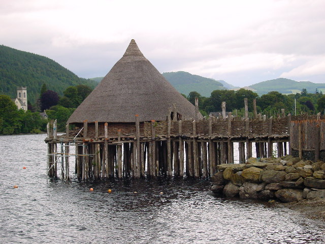
A crannog (; ga, crannóg ; gd, crannag ) is typically a partially or entirely artificial island, usually built in lakes and estuarine waters of Scotland, Wales, and Ireland. Unlike the prehistoric pile dwellings around the Alps, which were built on the shores and not inundated until later, crannogs were built in the water, thus forming artificial islands. Crannogs were used as dwellings over five millennia, from the European Neolithic Period to as late as the 17th/early 18th century. In Scotland there is no convincing evidence in the archaeological record of Early and Middle Bronze Age or Norse Period use. The radiocarbon dating obtained from key sites such as Oakbank and Redcastle indicates at a 95.4 per cent confidence level that they date to the Late Bronze Age to Early Iron Age. The date ranges fall ''after'' around 800 BC and so could be considered Late Bronze Age by only the narrowest of margins. Crannogs have been variously interpreted as free-standing wooden stru ... [...More Info...] [...Related Items...] OR: [Wikipedia] [Google] [Baidu] |


