|
Chiang Rak Noi, Sam Khok
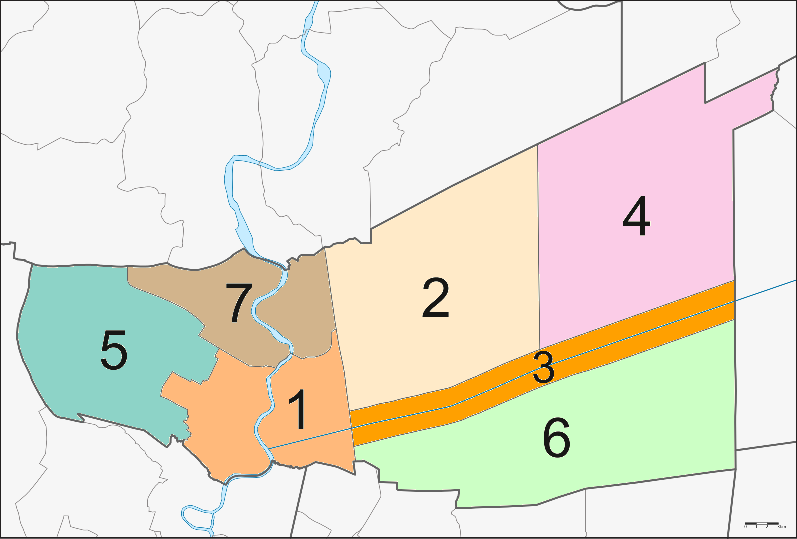
Chiang Rak Noi (, ) is a ''tambon'' (subdistrict) in Sam Khok district, upper part of Pathum Thani province. History Chiang Rak Noi was originally administered by the local government in the form of a Council Subistrict. Later in 1997, it was upgraded to Subdistrict Administrative Organization (SAO). Geography Most of the area is lowland, Chiang Rak Noi lies on the Chao Phraya eastern bank, and has many ''khlongs'' (canals) flowing through it. Therefore, most of the population is engaged in agriculture. Neighbouring subdistricts are (from the north clockwise): Chaing Rak Noi in Bang Sai district, Phra Nakhon Si Ayutthaya; Tha Khlong in Khlong Luang district in its province; Ban Ngio and Ban Pathum with (across Chao Phraya river) Thai Ko in its district. The subdistrict is from the downtown Sam Khok. Climate Rain falls in season and there is a fair amount of water, so there is enough water to use. Administration The entire area is under the administration of Subdistrict ... [...More Info...] [...Related Items...] OR: [Wikipedia] [Google] [Baidu] |
Tambon
''Tambon'' (, ) is a local governmental unit in Thailand. Below district (''amphoe'') and province ('' changwat''), they form the third administrative subdivision level. there were 7,255 tambons, not including the 180 ''khwaeng'' of Bangkok, which are set at the same administrative level, thus every district contains eight to ten tambon. ''Tambon'' is usually translated as "township" or "subdistrict" in English the latter is the recommended translation, though also often used for '' king amphoe'', the designation for a subdistrict acting as a branch (Thai: ''king'') of the parent district. Tambon are further subdivided into 74,944 villages (''muban'') as of 2008. ''Tambon'' within cities or towns are not subdivided into villages, but may have less formal communities called ''chumchon'' ( ชุมชน) that may be formed into community associations. The average area of a subdistrict in Thailand is about , while its average population of a subdistrict in Thailand is about 9,637 ... [...More Info...] [...Related Items...] OR: [Wikipedia] [Google] [Baidu] |
Pathum Thani Province
Pathum Thani (, ) is one of the central provinces (''changwat'') of Thailand. Neighboring provinces are (from north clockwise): Phra Nakhon Si Ayutthaya, Saraburi, Nakhon Nayok, Chachoengsao, Bangkok, and Nonthaburi. The province is north of Bangkok and is part of the Bangkok metropolitan area. In many places, the boundary between the two provinces is not noticeable as both sides of the boundary are equally urbanized. Pathum Thani town is the administrative seat, but Ban Rangsit, seat of Thanyaburi district, is the largest populated place in the province. Pathum Thani is an old province, heavily populated by the Mon people, dotted with 186 temples and parks. The Dream World amusement park is here. Geography The province lies on the low alluvial flats of the Chao Phraya River that flows through the capital. Many canals (''khlongs'') cross the province and feed the rice paddies. There is no forest area in the province. History The city dates back to a settlement founded by ... [...More Info...] [...Related Items...] OR: [Wikipedia] [Google] [Baidu] |
Rama II
Phutthaloetla Naphalai (born Chim; 24 February 1767 or 1768 – 21 July 1824), also known by his regnal name Rama II, was the second King of Siam from the Chakri dynasty, ruling from 1809 to 1824. In 1809, Itsarasunthon succeeded his father Rama I, the founder of the Chakri dynasty, as Loetlanaphalai the King of Siam. His reign was largely peaceful, devoid of major conflicts. His reign was known as the "Golden Age of Rattanakosin Literature" as Loetlanaphalai was patron to a number of poets in his court, and the King himself was a renowned poet and artist. The most notable poet in his employ was the illustrious Sunthorn Phu, the author of '' Phra Aphai Mani''. The rapid growth of the number of his descendants was outstanding: he is believed to have had over 240 grandchildren. Early life Chim was born in 1767 during the Ayutthaya Kingdom in Amphawa District, Samut Songkram. He was a son of Luang Yokkrabat of Ratchaburi and Nak of Samut Sakorn, as his father and mother were ... [...More Info...] [...Related Items...] OR: [Wikipedia] [Google] [Baidu] |
Mon People
The Mon (; Thai Mon: ဂကူမည်; , ; , ) are an ethnic group who inhabit Lower Myanmar's Mon State, Kayin State, Kayah State, Tanintharyi Region, Bago Region, the Irrawaddy Delta, and several areas in Thailand (mostly in Pathum Thani province, Phra Pradaeng and Nong Ya Plong). The native language is Mon, which belongs to the Monic branch of the Austroasiatic language family and shares a common origin with the Nyah Kur language, which is spoken by the people of the same name that live in Northeastern Thailand. A number of languages in Mainland Southeast Asia are influenced by the Mon language, which is also in turn influenced by those languages. The Mon were one of the earliest to reside in Southeast Asia, and were responsible for the spread of Theravada Buddhism in Mainland Southeast Asia. The civilizations founded by the Mon were some of the earliest in Thailand as well as Myanmar and Laos. The Mon are regarded as a large exporter of Southeast Asian cultur ... [...More Info...] [...Related Items...] OR: [Wikipedia] [Google] [Baidu] |
Muban
Muban (; , ) is the lowest Administrative divisions of Thailand, administrative sub-division of Thailand. Usually translated as 'village' and sometimes as 'hamlet (place), hamlet', they are a subdivision of a tambon (subdistrict). , there were 74,944 administrative mubans in Thailand. As of the 1990 census, the average village consisted of 144 households or 746 persons. The average land area of villages in Thailand is very small, its average area is about , and its average population is also very small, at only 932 people. Nomenclature ''Muban'' may function as one word, in the sense of a hamlet or village, and as such, it may be shortened to ''ban''. ''Mu ban'' may also function as two words, i.e., wikt:หมู่, หมู่ 'group' (of) wikt:บ้าน, บ้าน 'homes'. * ''Mu'', in the sense of group (of homes in a tambon), are assigned numbers in the sequence in which each is entered in a register maintained in the district or branch-district office. * ''Ban'', i ... [...More Info...] [...Related Items...] OR: [Wikipedia] [Google] [Baidu] |
Khlong Luang District
Khlong Luang (, ) is a district (''amphoe'') in Pathum Thani province, central Thailand. History Originally, the area was part of the Bang Wai District, controlled by ''Mueang'' Thanyaburi. In the Ayutthaya era, this area was lowland deep forest. In 1767 when the Ayutthaya Kingdom was destroyed by Burmese troops, some of the survivors moved to this area. When the community became bigger, people expanded agriculture until it was close to Thung Luang (now Thanyaburi district). King Rama V ordered a canal, Khlong Rangsit, to be built for agricultural purposes for the people in the Thung Luang and Bang Wai area. When the canal was finished, the government changed the name of the district to Khlong Luang to commemorate King Rama V's foresight. Geography Neighboring districts are (from the north clockwise): Bang Pa-in and Wang Noi of Phra Nakhon Si Ayutthaya province; Nong Suea, Thanyaburi, Mueang Pathum Thani, and Sam Khok of Pathum Thani Province. Administration The distric ... [...More Info...] [...Related Items...] OR: [Wikipedia] [Google] [Baidu] |
Tha Khlong
Tha Khlong (, ) is a ''Thesaban#Town municipality, thesaban mueang'' (town municipality) in the Khlong Luang District of Pathum Thani Province in the Bangkok Metropolitan Region of Central Thailand. History In the past, Tha Khlong was part of the vast field plain in central region known as "Thung Luang" (ทุ่งหลวง, "the great field") that consisted of various fields, such as Thung Rangsit (now Rangsit area), Thung Chiang Rak (now Chiang Rak area), etc. Its name literally translates to "the pier of the herd of elephants". Because it is a place where various wildlife such as Schomburgk's deers, Indochinese tiger, tigers, and Elephants in Thailand, wild elephants come to earn their living. Originally, it was established as Tha Khlong Subdistrict Municipality (เทศบาลตำบลท่าโขลง) on July 21, 1996 and consists of 31 communities. Later, when there was a rapid expansion both socially and economically. As a result, it has been upgraded t ... [...More Info...] [...Related Items...] OR: [Wikipedia] [Google] [Baidu] |
Phra Nakhon Si Ayutthaya (city)
Phra Nakhon Si Ayutthaya (, ), or locally and simply Ayutthaya is the capital of Phra Nakhon Si Ayutthaya province of Thailand. Ayutthaya was the capital of the Ayutthaya Kingdom. Located on an island at the confluence of the Chao Phraya River, Chao Phraya and Pa Sak River, Pa Sak rivers, Ayutthaya is the birthplace of the founder of Bangkok, Rama I, King Rama I. The ruins of the old city are preserved in the Ayutthaya Historical Park. Etymology The name ''Ayutthaya'' is derived from Sanskrit अयोध्य - Ayodhya (Ramayana), Ayodhya and is from the Thai national epic ''Ramakien''; (from Khmer language, Khmer: ''preah'' ព្រះ ) is a prefix for a noun concerning a royal person, and (from Pali: ''nagara'') designates an important or capital city. History Prior to Ayutthaya's traditional founding date, archaeological and written evidence has revealed that Ayutthaya may have existed as early as the late 13th century as a water-borne port town. Further evidence o ... [...More Info...] [...Related Items...] OR: [Wikipedia] [Google] [Baidu] |
Khlong
A ''khlong'' (, ), alternatively spelt as ''klong'' () commonly refers to a canal in Thailand. These canals are spawned by the rivers Chao Phraya, Tha Chin, and Mae Klong, along with their tributaries particularly in the low-lying areas of central Thailand. The Thai word ''khlong'' is not limited to artificial canals. Many smaller rivers are referred to as "''khlong''" followed by the name of the stream. Khlongs in Bangkok there are 1,682 canals in Bangkok, totalling 2,604 kilometres in length. Nine canals are primary flood drainage conduits. In years past, the Thai capital was crisscrossed by khlongs, and so gained the nickname "Venice of the East". Khlongs were used for transportation, for floating markets, but also for sewage disposal. Today, most of the khlongs of Bangkok have been filled in, although the Thonburi side of Bangkok (covering areas west of the Chao Phraya River) still retains several of its larger khlongs. Khlong Saen Saep Khlong Saen Saep (, ) is ... [...More Info...] [...Related Items...] OR: [Wikipedia] [Google] [Baidu] |
Chao Phraya
The Chao Phraya River is the major river in Thailand, with its low alluvial plain forming the centre of the country. It flows through Bangkok and then into the Gulf of Thailand. Etymology Written evidence of the river being referred to by the name ''Chao Phraya'' dates only to the reign of King Mongkut (Rama IV, 1850–1868). It is unknown what name, if any at all, was used for the river in older times. The river was likely known simply by the Thai word for 'river', (), and foreign documents and maps, especially by Europeans visiting during the Ayutthaya period, usually named the river the ''Menam''. The name Chao Phraya likely comes from (), an alternative name, documented from around 1660 in the reign of King Narai, of the settlement that is now Samut Prakan. Historian Praphat Chuvichean suggests that the name, which is a title of nobility, originated from the story of two Khmer idols being unearthed in 1498 at the settlement that was by the mouth of the river at the tim ... [...More Info...] [...Related Items...] OR: [Wikipedia] [Google] [Baidu] |


