|
Ceduna, South Australia
Ceduna ( ) is a town in South Australia located on the shores of Murat Bay on the coast, west of the Eyre Peninsula. It lies west of the junction of the Flinders Highway, South Australia, Flinders and Eyre Highways around 786 km northwest of Adelaide. The nearby port of Thevenard, South Australia, Thevenard lies 3 km to the west on Cape Thevenard. It is in the District Council of Ceduna, the federal electoral Division of Grey, and the state electoral district of Flinders. The name Ceduna is a local Australian Aborigine, Aboriginal Wirangu language, Wirangu word, alternatively phoneticized as ''Chedoona'', thought to mean a place to sit down and rest. The town is a fishing port and a railway hub. History The Wirangu people once lived over the area including Ceduna. Sea level rise 18,000 to 7,500 years ago completely displaced inhabitants of previous coastal areas and resulted in dramatic changes in distributions of peoples. Matthew Flinders, on his voyage in the ''I ... [...More Info...] [...Related Items...] OR: [Wikipedia] [Google] [Baidu] |
Electoral District Of Flinders
Flinders is a single-member electoral district for the South Australian House of Assembly. It is named after explorer Matthew Flinders, who was responsible for charting most of the state's coastline. It is a 58,901 km² coastal rural electorate encompassing the Eyre Peninsula and the coast along the Nullarbor Plain, based in and around the city of Port Lincoln and contains the District Councils of Ceduna, Cleve, Elliston, Lower Eyre Peninsula, Streaky Bay and Wudinna; as well as the localities of Fowlers Bay, Nullarbor and Yalata in the Pastoral Unincorporated Area. The seat was expanded in 2002 to include a western strip of land all the way to the Western Australia border. Flinders is the only one of the original 17 electorates to be contested at every election. Created as a single-member electorate in 1857, it was a dual-member electorate 1862–1875, 1884–1902 and 1915–1938, and a three-member electorate 1875–1884 and 1902–1915. A single-member electora ... [...More Info...] [...Related Items...] OR: [Wikipedia] [Google] [Baidu] |
Adelaide
Adelaide ( , ; ) is the list of Australian capital cities, capital and most populous city of South Australia, as well as the list of cities in Australia by population, fifth-most populous city in Australia. The name "Adelaide" may refer to either Greater Adelaide (including the Adelaide Hills) or the Adelaide city centre; the demonym ''Adelaidean'' is used to denote the city and the residents of Adelaide. The Native title in Australia#Traditional owner, traditional owners of the Adelaide region are the Kaurna, with the name referring to the area of the city centre and surrounding Adelaide Park Lands, Park Lands, in the Kaurna language. Adelaide is situated on the Adelaide Plains north of the Fleurieu Peninsula, between the Gulf St Vincent in the west and the Mount Lofty Ranges in the east. Its metropolitan area extends from the coast to the Adelaide Hills, foothills of the Mount Lofty Ranges, and stretches from Gawler in the north to Sellicks Beach in the south. Named in ho ... [...More Info...] [...Related Items...] OR: [Wikipedia] [Google] [Baidu] |
Joachim Murat
Joachim Murat ( , also ; ; ; 25 March 1767 – 13 October 1815) was a French Army officer and statesman who served during the French Revolutionary and Napoleonic Wars. Under the French Empire he received the military titles of Marshal of the Empire and Admiral of France. He was the first Prince Murat, Grand Duke of Berg from 1806 to 1808, and King of Naples as Joachim-Napoleon () from 1808 to 1815. Born in Labastide-Fortunière in southwestern France, Murat briefly pursued a vocation in the clergy before enlisting in a cavalry regiment upon the outbreak of the French Revolution. Murat distinguished himself under the command of General Napoleon Bonaparte on 13 Vendémiaire (1795), when he seized a group of large cannons and was instrumental in suppressing the royalist insurrection in Paris. He became Napoleon's aide-de-camp and commanded the cavalry during the French campaigns in Italy and Egypt. Murat played a pivotal role in the Coup of 18 Brumaire (1799), which brough ... [...More Info...] [...Related Items...] OR: [Wikipedia] [Google] [Baidu] |
Nicolas Baudin
Nicolas Thomas Baudin (; 17 February 175416 September 1803) was a French explorer, cartographer, naturalist and hydrographer, most notable for his explorations in Australia and the southern Pacific. He carried a few corms of Gros Michel banana from Southeast Asia, depositing them at a botanical garden on the Caribbean island of Martinique. Biography Early career Born a commoner in Saint-Martin-de-Ré on the Île de Ré on 17 February 1754, Nicolas Baudin joined the merchant navy as an apprentice () at the age of 15; he was then "of average height with brown hair". He then joined the French East India Company at the age of 20 on ''Flamand''. He returned from India on ''L'Étoile'' and arrived at Lorient. At the beginning of 1778, he was to set sail from Nantes on ''Lion'' as second lieutenant. It was a ship equipped by his uncle, Jean Peltier Dudoyer, at the request of the Americans, which would become a privateer and be renamed ''Deane''. At first the Minister for the N ... [...More Info...] [...Related Items...] OR: [Wikipedia] [Google] [Baidu] |
Nuyts Archipelago
The Nuyts Archipelago is an island group in South Australia in the Great Australian Bight, to the south of the town of Ceduna on the west coast of the Eyre Peninsula. It consists of mostly granitic islands and reefs that provide breeding sites for Australian sea lions and support colonies of short-tailed shearwater. It also includes the island group known as the Isles of St Francis. All the islands, with the exception of a part of Evans Island, are located within the protected areas of the Nuyts Archipelago Wilderness Protection Area and the Nuyts Archipelago Conservation Park. Description Of the roughly 30 islands and reefs in the archipelago, those lying furthest from the coast of the Eyre Peninsula are the Isles of St Francis, after the largest. Most of the islands are formed of calcarenite lying on granite; where the softer calcarenite is close to sea level it has been heavily eroded by wave action. The area is biologically unique in South Australia due to the in ... [...More Info...] [...Related Items...] OR: [Wikipedia] [Google] [Baidu] |
Smoky Bay
Smoky or Smokey may refer to: People * Smoky Babe (1927–1975), American acoustic blues guitarist and singer born Robert Brown * Smoky Burgess (1927–1991), American Major League Baseball catcher * Smoky Dawson (1913–2008), Australian country music performer born Herbert Brown * Henry Harris (ice hockey) (1905-1975), Canadian hockey player * Smoky Owens (1912-1942), American baseball pitcher in the Negro leagues * Smokey Robinson (born 1940), American R&B singer and songwriter * Smokey Rogers, American Western swing musician Eugene Rogers (1917–1993) * Ernest Smith (1914–2005), Canadian recipient of the Victoria Cross * Smoky Joe Wood (1889–1985), American Major League Baseball pitcher * Smokey Yunick (1923–2001), NASCAR designer * Lois Smoky Kaulaity (1907–1981), Kiowa painter Places * Smoky Cape, Australia * Smoky Dome, a mountain in Idaho * Smoky Group, a Canadian geologic formation * Smoky Hills, central United States * Smoky Lake (Blaine County, Idaho ... [...More Info...] [...Related Items...] OR: [Wikipedia] [Google] [Baidu] |
Denial Bay
Denial Bay (formerly McKenzie) is a town and an associated locality in the Australian state of South Australia located on the state's west coast about north-west of the state capital of Adelaide and about west of the municipal seat of Ceduna. The town which is located on the western side of Murat Bay has extensive European history, first built on in 1889, and now hosts a large expanse of oyster farms, one of the largest on the Eyre Peninsula. History The bay which the town is named after initially mapped by Matthew Flinders in 1802, as part of a wider attempt to map South Australia's coastline. Flinders named the inlet "Denial Bay" because of "''the deceptive hope we had formed of penetrating by it some distance into the interior of the country''". The first European exploration of the hinterland was in August 1839 by John Hill and Samuel Stephens, using the chartered brig ''Rapid'' as a base. The town was established by William McKenzie in 1889 as the first settlement in ... [...More Info...] [...Related Items...] OR: [Wikipedia] [Google] [Baidu] |
Matthew Flinders
Captain (Royal Navy), Captain Matthew Flinders (16 March 1774 – 19 July 1814) was a British Royal Navy officer, navigator and cartographer who led the first littoral zone, inshore circumnavigate, circumnavigation of mainland Australia, then called New Holland (Australia), New Holland. He is also credited as being the first person to utilise the name ''Australia'' to describe the entirety of that continent including Van Diemen's Land (now Tasmania), a title he regarded as being "more agreeable to the ear" than previous names such as ''Terra Australis''. Flinders was involved in several voyages of discovery between 1791 and 1803, the most famous of which are the circumnavigation of Australia and an earlier expedition when he and George Bass confirmed that Van Diemen's Land was an island. While returning to Britain in 1803, Flinders was arrested by the French at the colony of Isle de France (Mauritius), Isle de France. Although Britain and France were at war, Flinders thought t ... [...More Info...] [...Related Items...] OR: [Wikipedia] [Google] [Baidu] |
Wirangu People
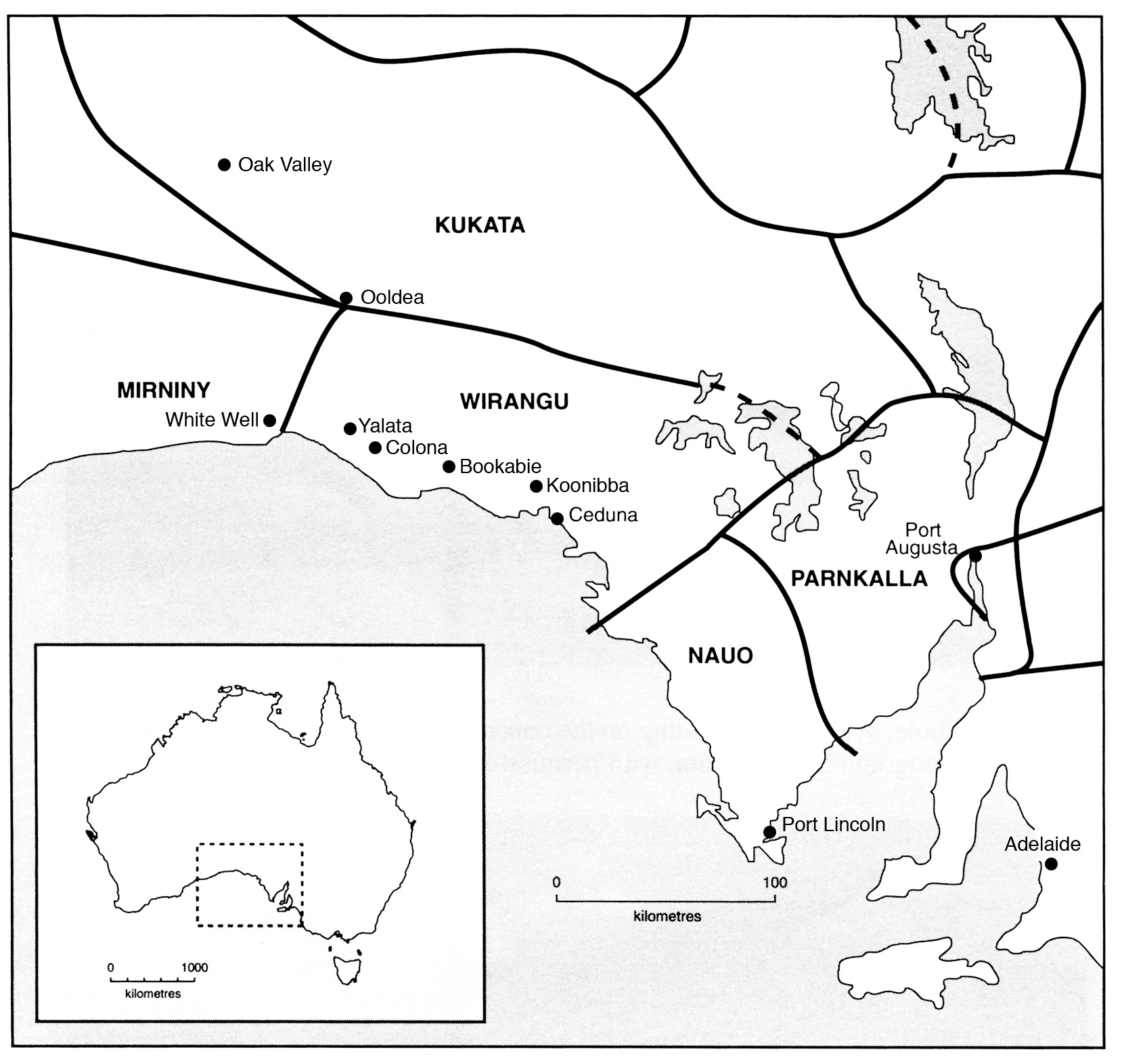
The Wirangu are an Aboriginal Australian people of the Western coastal region of South Australia. Name Daisy Bates stated that the Wirangu ethnonym was composed of two words: ''wira'' (cloud) and ''wonga'' (speech). Language Wirangu is usually classified as genetically related to the Thura-Yura language family. Early ethnographers, such as R. H. Mathews stated that the Barngarla, Nauo and Wirangu peoples were "practically the same people in language and customs". Country In Norman Tindale's estimation, the Wirangu were assigned an original tribal land extending over , embracing the coastal area between Head of Bight, Cape Blanche and Streaky Bay, with an inland extension running north to places like Ooldea, Kokatha, and Kondoolka. Mythology In ancestral times a large mother snake travelled down from the west to ''Juldi'kapi''. From there it was followed by two men (the ''Wati Kutjara'') who wished to kill it. They chased the snake south-east to Pedinga water-hole ... [...More Info...] [...Related Items...] OR: [Wikipedia] [Google] [Baidu] |
Wirangu Language
The Wirangu language, also written Wirrongu, Wirrung, Wirrunga, and Wirangga, and also known by other exonyms, is a moribund Australian Aboriginal language traditionally spoken by the Wirangu people, living on the west coast of South Australia across a region encompassing modern Ceduna and Streaky Bay, stretching west approximately to the head of the Great Australian Bight and east to Lake Gairdner. It is a language of the Thura-Yura group, and some older sources placed it in a subgroup called Nangga. Classification and influences The Wirangu language is most closely related to the Thura–Yura group of Australian Aboriginal languages, which are spoken from the West Coast to the Adelaide area and north to the Flinders Ranges and Lake Eyre. The best-known relatives of Wirangu are Barngarla, Nauo, Nukunu, Adnyamathanha, Narangga and Kaurna. Because of the intensive culture contacts in the southern half of South Australia, which brought dislocation and culture change, ... [...More Info...] [...Related Items...] OR: [Wikipedia] [Google] [Baidu] |


