|
Carrick-on-Suir
Carrick-on-Suir () is a town in County Tipperary, Republic of Ireland, Ireland. It lies on both banks of the River Suir. The part on the north bank of the Suir lies in the Civil parishes in Ireland, civil parish of "Carrick", in the historical Barony (Ireland), barony of Iffa and Offa East. The part on the south bank lies in the civil parish of Kilmolerin in the barony of Upperthird, County Waterford. Location Carrick-on-Suir is situated in the south-eastern corner of County Tipperary, east of Clonmel and northwest of Waterford. Most of the town lies north of the river in the townland of ''Carrig Mór'' (big rock), with the remainder of the town on the opposite bank in the townland of ''Carrig Beg'' (small rock). The town is connected to Limerick and Waterford by the N24 road (Ireland), N24 road and a rail transport in Ireland, rail link. Carrick-on-Suir railway station opened on 15 April 1853. There are two trains a day to Waterford and two trains a day to Limerick Junction ... [...More Info...] [...Related Items...] OR: [Wikipedia] [Google] [Baidu] |
Carrick-on-Suir Railway Station
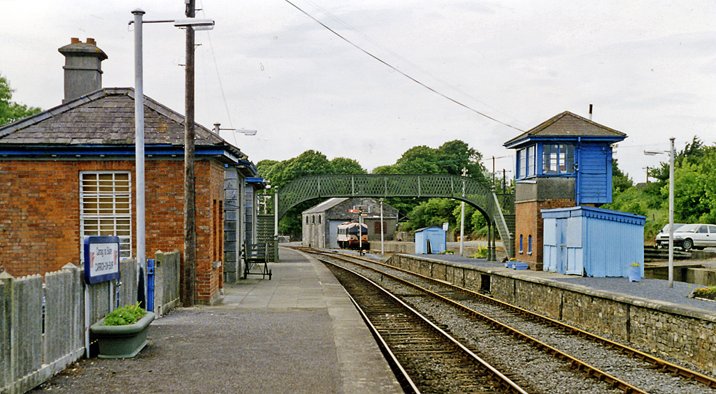
Carrick-on-Suir railway station serves the town of Carrick-on-Suir, County Tipperary in Ireland Ireland (, ; ; Ulster Scots dialect, Ulster-Scots: ) is an island in the North Atlantic Ocean, in Northwestern Europe. Geopolitically, the island is divided between the Republic of Ireland (officially Names of the Irish state, named Irelan .... It has a weekday passenger service of two trains to Waterford and two to Limerick Junction. There is no Sunday service. Until 19 January 2013 (inclusive) there were three trains each way. However the late-morning Waterford to Limerick Junction and early-afternoon Limerick Junction to Waterford trains are now discontinued. The station consists of two platforms, a waiting room, toilets and small car park at present free for rail passengers. The second platform, on which the signal cabin is located, was served by a passing loop until November 2013. There is also a siding, used by the Irish Traction Group to store preserved diesel loco ... [...More Info...] [...Related Items...] OR: [Wikipedia] [Google] [Baidu] |
Rail Transport In Ireland
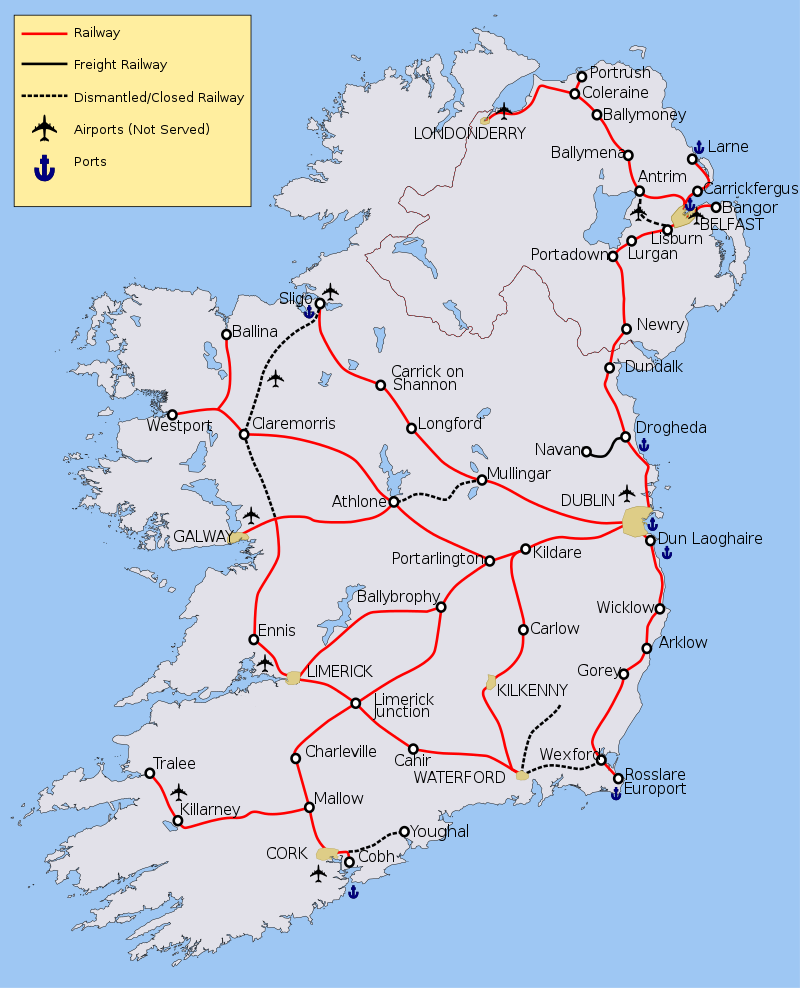
Rail transport in Ireland (InterCity, commuter and freight) is provided by Iarnród Éireann in the Republic of Ireland and by Northern Ireland Railways in Northern Ireland. Most routes in the Republic radiate from Dublin. Northern Ireland has suburban routes from Belfast and two main InterCity lines, to Derry and cross-Irish border, border to Dublin. The accompanying map of the current railway network shows lines that are fully operational (in red), carrying freight only traffic (in black) and with dotted black lines those which have been "mothballed" (i.e. closed to traffic but potentially easy to re-open). Some airports are indicated but none are rail-connected, although Kerry Airport and Belfast City Airport are within walking distance of a railway station. Both the City of Derry Airport and Belfast International Airport, Belfast International (Aldergrove) are near railway lines but not connected. Ports are marked, although few remain rail-connected. Dublin Port, Larne Har ... [...More Info...] [...Related Items...] OR: [Wikipedia] [Google] [Baidu] |
Iffa And Offa East
Iffa and Offa East ( Irish: ''Uíbh Eoghain agus Uíbh Fhathaidh Thoir'') is a barony in County Tipperary, Ireland. This geographical unit of land is one of 12 baronies in County Tipperary. Its chief town is Clonmel. The barony lies between Iffa and Offa West to the west (whose chief town is Cahir), Middle Third to the north-west (whose chief town is Cashel) and Slievardagh to the north-east (whose chief town is Mullinahone). It is currently administered by Tipperary County Council. The entire barony lies within the geographic remit of the Roman Catholic Diocese of Waterford and Lismore with the exception of the parish of Clerihan which is in the Roman Catholic Archdiocese of Cashel and Emly. Legal context Baronies were created after the Norman invasion of Ireland as divisions of counties and were used the administration of justice and the raising of revenue. While baronies continue to be officially defined units, they have been administratively obsolete since 1898. Howe ... [...More Info...] [...Related Items...] OR: [Wikipedia] [Google] [Baidu] |
N24 Road (Ireland)
The N24 road is a national primary road in Ireland forming a route from Limerick to Waterford, running through County Tipperary and passing Tipperary town, Cahir, Carrick-on-Suir and Clonmel. The route begins at its junction with the Limerick Southern M7 ring road (Junction 29). Pallasgreen and Oola are two small villages through which the route passes before reaching Tipperary town. Before the town the road passes by Limerick Junction, a major railway intersection for the region where the Dublin- Cork and Dublin-Limerick lines meet. Bansha lies further southeast along the route, and the road passes under and then meets the M8 Cork–Dublin motorway at Junction 10 just outside Cahir. The N24 passes north of Cahir, turning east towards Clonmel. A bypass brings the road around the north of Clonmel. After Clonmel the N24 meets the N76 which leads to Kilkenny and the many towns and villages which the road passes or travels near. After the roundabout, the N24 continues east ... [...More Info...] [...Related Items...] OR: [Wikipedia] [Google] [Baidu] |
County Tipperary
County Tipperary () is a Counties of Ireland, county in Republic of Ireland, Ireland. It is in the Provinces of Ireland, province of Munster and the Southern Region, Ireland, Southern Region. The county is named after the town of Tipperary (town), Tipperary, and was established in the early 13th century, shortly after the Norman invasion of Ireland. It is Ireland's largest inland county and shares a border with eight counties, more than any other. The population of the county was 167,895 at the 2022 census. The largest towns are Clonmel, Nenagh and Thurles. Tipperary County Council is the local government in the Republic of Ireland, local authority for the county. In 1838, County Tipperary was divided into two Riding (division), ridings, North Tipperary, North and South Tipperary, South. From 1899 until 2014, they had their own county councils. They were unified under the Local Government Reform Act 2014, which came into effect following the 2014 Irish local elections, 2014 loca ... [...More Info...] [...Related Items...] OR: [Wikipedia] [Google] [Baidu] |
River Suir
The River Suir ( ; or ''Abhainn na Siúire'' ) is a river in Ireland that flows into the Atlantic Ocean through Waterford after a distance of . The catchment area of the Suir is 3,610 km2.South Eastern River Basin District Management System. Page 38 Its long-term average flow rate is 76.9 cubic metres per second (m3/s), about twice the flow of either the River Barrow (37.4 m3/s) or the River Nore (42.9 m3/s) before these join, but a little less than the Barrow's flow when it meets the Suir 20 km downstream (over 80 m3/s). Popular with anglers, it abounds in brown trout and salmon. Although the Suir holds the record for a salmon taken from an Irish river (weighing 57 lb/ ... [...More Info...] [...Related Items...] OR: [Wikipedia] [Google] [Baidu] |
Upperthird
Upperthird or Upper Third () is a barony in County Waterford, Ireland. Etymology Upperthird was originally called ''Uachtar Tíre'', "upper country", referring to its high altitude (by Irish standards). ''Tír'' became "third" presumably by analogy with Middle Third; "third" is commonly used to indicate Irish divisions of land, without any region being actually divided in three. Geography Upperthird is located in the Waterford uplands to the south of the River Suir and north of the River Nier, containing most of the Comeragh Mountains and the Clodiagh River valley. It also contains two large lakes, Coumshingaun Lough and Crotty's Lake. It was known as a source of quartz. History This part of the Suir valley was the traditional territory of the O'Flanagan of Upperthird (''Ó Flannagáin Uachtar Tíre''). It contains Mothel Abbey, an ecclesiastical centre from the 6th to 16th centuries AD. Abraham Ortelius's map of 1602 shows the land belonging to the Aylward family (an ... [...More Info...] [...Related Items...] OR: [Wikipedia] [Google] [Baidu] |
1247 In Ireland
Events from the year 1247 in Ireland. Incumbent *Lord: Henry III Events *The earliest known records of a settlement at Carrick-on-Suir are dated to 1247, when a charter of three fairs per year was awarded to Matthew Fitzgriffin, Anglo-Norman Lord of the Manor of Carrick. *Battle between Anglo-Normans and Irish led to the Sack of Dun Gallimhe by Irish forces. Births Deaths References 1240s in Ireland Ireland Ireland (, ; ; Ulster Scots dialect, Ulster-Scots: ) is an island in the North Atlantic Ocean, in Northwestern Europe. Geopolitically, the island is divided between the Republic of Ireland (officially Names of the Irish state, named Irelan ... Years of the 13th century in Ireland {{Ireland-hist-stub ... [...More Info...] [...Related Items...] OR: [Wikipedia] [Google] [Baidu] |
Tipperary (Dáil Constituency)
Tipperary was a parliamentary constituency that was represented in Dáil Éireann, the house of representatives of the Oireachtas (the legislature of Ireland), from 1923 to 1948 and again from 2016 to 2024. The constituency elected deputies ( Teachtaí Dála, commonly known as TDs) on the system of proportional representation by means of the single transferable vote (PR-STV). History and boundaries The constituency was created under the Electoral Act 1923, and was first used at the 1923 general election, incorporating the separate counties of North Tipperary and South Tipperary. It was abolished in 1948. The Constituency Commission proposed in its 2012 report that at the next general election a new constituency called Tipperary be created, as part of changes that reduced the total number of TDs from 166 to 158. This occurred in 2016, shortly after the administrative amalgamation in 2014 of the separate counties to form County Tipperary. In August 2023, the Electoral Commiss ... [...More Info...] [...Related Items...] OR: [Wikipedia] [Google] [Baidu] |
Limerick
Limerick ( ; ) is a city in western Ireland, in County Limerick. It is in the Provinces of Ireland, province of Munster and is in the Mid-West Region, Ireland, Mid-West which comprises part of the Southern Region, Ireland, Southern Region. With a population of 102,287 at the 2022 census of Ireland, 2022 census, Limerick is the List of urban areas in the Republic of Ireland, third-most populous urban area in Republic of Ireland, Ireland, and the List of settlements on the island of Ireland by population, fourth-most populous city on the island of Ireland. It was founded by Scandinavian settlers in 812, during the Viking Age. The city straddles the River Shannon, with the historic core of the city located on King's Island, Limerick, King's Island, which is bounded by the Shannon and Abbey River, Limerick, Abbey Rivers. Limerick is at the head of the Shannon Estuary, where the river widens before it flows into the Atlantic Ocean. Limerick City and County Council is the Local gov ... [...More Info...] [...Related Items...] OR: [Wikipedia] [Google] [Baidu] |
Telephone Numbers In The Republic Of Ireland
Numbers on the Irish telephone numbering plan are regulated and assigned to operators by ComReg. Overview Telephone numbers in Ireland are part of an open numbering plan that allows variations in number length. The Irish format is similar to systems used in many parts of Europe, notably the Netherlands, Sweden, Germany, Belgium and France, where geographical numbers are organised using a logic of large regional prefixes, which are then further subdivided into smaller regions. It differs from UK numbering, which originated as alphanumeric codes based on town names. Irish Mobile and non–geographic numbers are fixed length and do not support local dialling. The trunk prefix 0 is used to access numbers outside the local area and for all mobile calls. This is followed by an area code, referred to as a National Dialling Code (NDC), the first digit of which indicates the geographical area or type of service (e.g. mobile). Calls made from mobile phones and some VoIP systems always ... [...More Info...] [...Related Items...] OR: [Wikipedia] [Google] [Baidu] |
Eircode
A postal address in Ireland is a place of Delivery (commerce), delivery defined by Irish Standard (IS) EN 14142-1:2011 ("Postal services. Address databases") and serviced by the universal service provider, . Its addressing guides comply with the guidelines of the Universal Postal Union (UPU), the United Nations-affiliated body responsible for promoting standards in the postal industry, across the world. In Ireland, 35% of premises (over 600,000) have non-unique addresses due to an absence of house numbers or names. Before the introduction of a national postcode system (Eircode) in 2015, this required postal workers to remember which family names corresponded to which house in smaller towns, and many townlands. , An Post encourages customers to use Eircode because it ensures that their post person can pinpoint the exact location. Ireland was the last country in the OECD to create a postcode system. In July 2015 all 2.2 million residential and business addresses in Ireland r ... [...More Info...] [...Related Items...] OR: [Wikipedia] [Google] [Baidu] |


