|
Cape Kamui
is located on the western part of Shakotan, Hokkaido, Japan. Its lighthouse, the Cape Kamui Lighthouse, overlooks the Sea of Japan. An earthquake off the cape on 2 August 1940 resulted in a tsunami A tsunami ( ; from , ) is a series of waves in a water body caused by the displacement of a large volume of water, generally in an ocean or a large lake. Earthquakes, volcanic eruptions and underwater explosions (including detonations, ... that killed ten people. Gallery File:130823 Cape Kamui Shakotan Hokkaido Japan08s3.jpg, East bank File:130823 Cape Kamui Shakotan Hokkaido Japan14s3.jpg, West bank File:kamui gate.jpg, Entrance File:Radar at Cape Kamui 01.jpg, Radio tower File:P7030384.JPG, Cape Kamui Lighthouse See also * Niseko-Shakotan-Otaru Kaigan Quasi-National Park References External links Kamui Hokkaido Heritage {{Hokkaidō-geo-stub ... [...More Info...] [...Related Items...] OR: [Wikipedia] [Google] [Baidu] |
Cape (geography)
In geography, a cape is a headland, peninsula or promontory extending into a body of water, usually a sea. A cape usually represents a marked change in trend of the Coast, coastline, often making them important landmarks in sea navigation. This also makes them prone to natural forms of erosion, mainly tidal actions, resulting in a relatively short geological lifespan. Formation Capes can be formed by Glacier, glaciers, Volcano, volcanoes, and changes in sea level. Erosion plays a large role in each of these methods of formation. Coastal erosion by waves and currents can create capes by wearing away softer rock and leaving behind harder rock formations. Movements of the Earth's crust can uplift land, forming capes. For example, the Cape of Good Hope was formed by tectonic forces. Volcanic eruptions can create capes by depositing lava that solidifies into new landforms. Cape Verde, (also known as Cabo Verde) is an example of a volcanic cape. Glaciers can carve out capes by erod ... [...More Info...] [...Related Items...] OR: [Wikipedia] [Google] [Baidu] |
Shakotan Peninsula
The in Shiribeshi, on the west coast of Hokkaidō, Japan, is a mountainous peninsula which projects some into the Sea of Japan. The Shakotan Peninsula forms part of the Niseko-Shakotan-Otaru Kaigan Quasi-National Park. Geography The peninsula has a rugged terrain with few level areas. The coastline of the peninsula suffers from extensive marine erosion, which resulted in the numerous natural stone pillars which project from the sea. Mount Shakotan () forms the highest peak on the peninsula. The peninsula has numerous scenic capes and inlet An inlet is a typically long and narrow indentation of a shoreline such as a small arm, cove, bay, sound, fjord, lagoon or marsh, that leads to an enclosed larger body of water such as a lake, estuary, gulf or marginal sea. Overview In ...s, notably Cape Shakotan and Cape Kamui. Municipalities The Shakotan Peninsula spans seven municipalities in Hokkaidō, all within Shiribeshi Subprefecture. * Iwanai (East entrance ... [...More Info...] [...Related Items...] OR: [Wikipedia] [Google] [Baidu] |
Hokkaido
is the list of islands of Japan by area, second-largest island of Japan and comprises the largest and northernmost prefectures of Japan, prefecture, making up its own list of regions of Japan, region. The Tsugaru Strait separates Hokkaidō from Honshu; the two islands are connected by railway via the Seikan Tunnel. The largest city on Hokkaido is its capital, Sapporo, which is also its only cities designated by government ordinance of Japan, ordinance-designated city. Sakhalin lies about to the north of Hokkaidō, and to the east and northeast are the Kuril Islands, which are administered by Russia, though the four most southerly are Kuril Islands dispute, claimed by Japan. The position of the island on the northern end of the archipelago results in a colder climate, with the island seeing significant snowfall each winter. Despite the harsher climate, it serves as an agricultural breadbasket for many crops. Hokkaido was formerly known as ''Ezo'', ''Yezo'', ''Yeso'', or ''Yes ... [...More Info...] [...Related Items...] OR: [Wikipedia] [Google] [Baidu] |
Japan
Japan is an island country in East Asia. Located in the Pacific Ocean off the northeast coast of the Asia, Asian mainland, it is bordered on the west by the Sea of Japan and extends from the Sea of Okhotsk in the north to the East China Sea in the south. The Japanese archipelago consists of four major islands—Hokkaido, Honshu, Shikoku, and Kyushu—and List of islands of Japan, thousands of smaller islands, covering . Japan has a population of over 123 million as of 2025, making it the List of countries and dependencies by population, eleventh-most populous country. The capital of Japan and List of cities in Japan, its largest city is Tokyo; the Greater Tokyo Area is the List of largest cities, largest metropolitan area in the world, with more than 37 million inhabitants as of 2024. Japan is divided into 47 Prefectures of Japan, administrative prefectures and List of regions of Japan, eight traditional regions. About three-quarters of Geography of Japan, the countr ... [...More Info...] [...Related Items...] OR: [Wikipedia] [Google] [Baidu] |
Sea Of Japan
The Sea of Japan is the marginal sea between the Japanese archipelago, Sakhalin, the Korean Peninsula, and the mainland of the Russian Far East. The Japanese archipelago separates the sea from the Pacific Ocean. Like the Mediterranean Sea, it has almost no tides due to its nearly complete enclosure from the Pacific Ocean. This isolation also affects faunal diversity and salinity, both of which are lower than in the open ocean. The sea has no large islands, bays or capes. Its water balance is mostly determined by the inflow and outflow through the straits connecting it to the neighboring seas and the Pacific Ocean. Few rivers discharge into the sea and their total contribution to the water exchange is within 1%. The seawater has an elevated concentration of Oxygen saturation, dissolved oxygen that results in high biological productivity. Therefore, fishing is the dominant economic activity in the region. The intensity of shipments across the sea has been moderate owing to politi ... [...More Info...] [...Related Items...] OR: [Wikipedia] [Google] [Baidu] |
Shakotan, Hokkaido
is a List of towns in Japan, town located in Shiribeshi Subprefecture, Hokkaido, Japan. As of September 2016, the town had a population of 2,215, and a population density, density of 9.3 persons per km2. The total area of the town is , and located west of Sapporo, the capital and economic hub of Hokkaido. Shakotan occupies the north of the Shakotan Peninsula. It was founded in 1869 as part of the short-lived Shiribeshi Province, which was dissolved in 1882 to become Hokkaido. Shakotan, along with neighboring Otaru, Hokkaido, Otaru, is home to Japan's only national-level marine sanctuary. Shakotan is home to the three great capes of the Shakotan Peninsula: Cape Kamui, Kamui, Cape Shakotan, Shakotan, and Cape Ōgon, Ōgon. Etymology The name of the town originates from the word "ShakKotan" in the Ainu language. It is formed from two words, the first, "shak", meaning "summer", and the second, "kotan", meaning "village". In the Japanese language the name of the town is written with ... [...More Info...] [...Related Items...] OR: [Wikipedia] [Google] [Baidu] |
Shakotan, Hokkaidō
is a town located in Shiribeshi Subprefecture, Hokkaido, Japan. As of September 2016, the town had a population of 2,215, and a density of 9.3 persons per km2. The total area of the town is , and located west of Sapporo, the capital and economic hub of Hokkaido. Shakotan occupies the north of the Shakotan Peninsula. It was founded in 1869 as part of the short-lived Shiribeshi Province, which was dissolved in 1882 to become Hokkaido. Shakotan, along with neighboring Otaru, is home to Japan's only national-level marine sanctuary. Shakotan is home to the three great capes of the Shakotan Peninsula: Kamui, Shakotan, and Ōgon. Etymology The name of the town originates from the word "ShakKotan" in the Ainu language. It is formed from two words, the first, "shak", meaning "summer", and the second, "kotan", meaning "village". In the Japanese language the name of the town is written with ''ateji'', or kanji characters used to phonetically represent native or borrowed words. The fi ... [...More Info...] [...Related Items...] OR: [Wikipedia] [Google] [Baidu] |
Cape Kamui Lighthouse
A cape is a clothing accessory or a sleeveless outer garment of any length that hangs loosely and connects either at the neck or shoulders. They usually cover the back, shoulders, and arms. They come in a variety of styles and have been used throughout history for many different reasons. Semantic distinction In fashion, the word "cape" usually refers to a shorter garment and "cloak" to a full-length version of the different types of garment, though the two terms are sometimes used synonymously for full-length coverings. A shoulder cape is thus sometimes called a "capelet". The fashion cape does not cover the front to any appreciable degree. In raingear, a cape is usually a long and roomy protective garment worn to keep one dry in the rain. History The first known usage of capes is unknown, but some early references we know of are from Ancient Roman military uniforms. Later on, capes were common in medieval Europe, especially when combined with a hood in the chaperon. They ... [...More Info...] [...Related Items...] OR: [Wikipedia] [Google] [Baidu] |
1940 Shakotan Earthquake
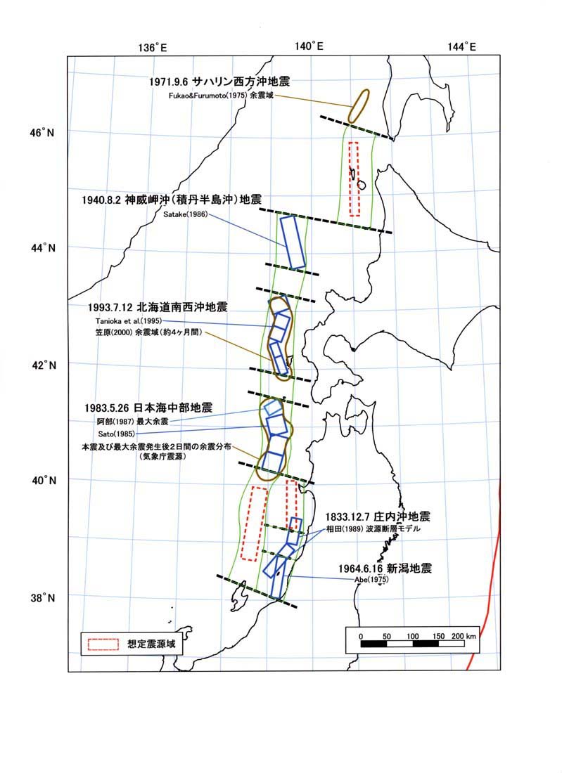
The 1940 Shakotan earthquake occurred on August 2 at 00:08:22 Japan Standard Time, JST with a moment magnitude () of 7.5 and maximum Japan Meteorological Agency seismic intensity scale, JMA seismic intensity of ''Shindo'' 4. The shock had an epicenter off the coast of Hokkaido, Japan. Damage from the shock was comparatively light, but the accomanying tsunami was destructive. The tsunami caused 10 deaths and 24 injuries on Hokkaido, and destroyed homes and boats across the Sea of Japan. The highest tsunami waves () were recorded at the coast of Russia while along the coast of Hokkaido, waves were about . Tectonic setting Japan is situated on a convergent boundary between the Pacific, Philippine Sea, Okhotsk Plate, Okhotsk and Amurian Plates. Along the island arc's east and southeast coast, subduction of the Pacific and Philippine Sea Plates occur at the Japan Trench and Nankai Trough, respectively. The Sea of Japan located off Japan's west coast is a back-arc basin which formed ... [...More Info...] [...Related Items...] OR: [Wikipedia] [Google] [Baidu] |


