|
Cape Agulhas
Cape Agulhas (; , "Cape of Needles") is a rocky headland in Western Cape, South Africa. It is the geographic southern tip of Africa and the beginning of the traditional dividing line between the Atlantic and Indian oceans according to the International Hydrographic Organization. It is approximately half a degree of latitude, or , farther south than the Cape of Good Hope. Historically, the cape has been known to sailors as a major hazard on the traditional clipper route. It is sometimes regarded as one of the great capes. It was most commonly known in English as Cape L'Agulhas until the 20th century. The town of L'Agulhas is near the cape. Geography Cape Agulhas is located in the Overberg region, 170 kilometres (105 mi) southeast of Cape Town. The cape was named by Portuguese navigators, who called it ''Cabo das Agulhas''— Portuguese for "Cape of Needles"—after noticing that around the year 1500 the direction of magnetic north (and therefore the compass ne ... [...More Info...] [...Related Items...] OR: [Wikipedia] [Google] [Baidu] |
L'Agulhas
L'Agulhas is the southernmost seaside resort, coastal village and holiday resort in South Africa, located within the Cape Agulhas Local Municipality at the southernmost tip of the African mainland. It is situated next to the town of Struisbaai and about south of the regional centre of Bredasdorp. Some of the older residents and documents refer to the town as by its former name Cape Agulhas or Cape L'Agulhas or simply Agulhas which were the names that referred to this town before it was changed to L'Agulhas to avoid confusion when the Bredasdorp Municipality changed its name to Cape_Agulhas_Local_Municipality, The Cape Agulhas Municipality (CAM). Etymology Agulhas is the plural form of “agulha” in Portuguese language, Portuguese. It is derived from the Late Latin word, “acūcula,” and the Latin word “acula,” both meaning a needle or pin. They trace back to the theorized Proto-Indo-European language, Proto-Indo-European word “h₂eḱ.” According to local legend, ... [...More Info...] [...Related Items...] OR: [Wikipedia] [Google] [Baidu] |
Agulhas ''
{{disambig ...
Agulhas (''needles'' in the Portuguese language — or ) may refer to: * Cape Agulhas, the southernmost point of Africa * L'Agulhas, a town near the Cape * Cape Agulhas Lighthouse, located at the Cape * Cape Agulhas Local Municipality, the municipality governing the area around Bredasdorp, including the Cape * Agulhas National Park, a national park protecting areas around Cape Agulhas * The Agulhas Bank, an area of ocean south of the Cape * The Agulhas Current, an ocean current off the east coast of South Africa * South African research ships: : **''S. A. Agulhas'' **''S. A. Agulhas II ''S. A. Agulhas II'' is a South African icebreaking polar supply and research vessel owned by the Department of Forestry, Fisheries and the Environment. She was built in 2012 by STX Finland Rauma shipyard in Rauma, Finland, to replace the ... [...More Info...] [...Related Items...] OR: [Wikipedia] [Google] [Baidu] |
Portuguese Discoveries
Portuguese maritime explorations resulted in numerous territories and maritime routes recorded by the Portuguese on journeys during the 15th and 16th centuries. Portuguese sailors were at the vanguard of European exploration, chronicling and mapping the coasts of Africa and Asia, then known as the East Indies, Canada and Brazil (the West Indies), in what became known as the Age of Discovery. Methodical expeditions started in 1419 along the coast of West Africa under the sponsorship of prince Henry the Navigator, whence Bartolomeu Dias reached the Cape of Good Hope and entered the Indian Ocean in 1488. Ten years later, in 1498, Vasco da Gama led the first fleet around Africa to the Indian subcontinent, arriving in Calicut and starting a maritime route from Portugal to India. Portuguese explorations then proceeded to southeast Asia, where they reached Japan in 1542, forty-four years after their first arrival in India. In 1500, the Portuguese nobleman Pedro Álvares Cabral beca ... [...More Info...] [...Related Items...] OR: [Wikipedia] [Google] [Baidu] |
Köppen Climate Classification
The Köppen climate classification divides Earth climates into five main climate groups, with each group being divided based on patterns of seasonal precipitation and temperature. The five main groups are ''A'' (tropical), ''B'' (arid), ''C'' (temperate), ''D'' (continental), and ''E'' (polar). Each group and subgroup is represented by a letter. All climates are assigned a main group (the first letter). All climates except for those in the ''E'' group are assigned a seasonal precipitation subgroup (the second letter). For example, ''Af'' indicates a tropical rainforest climate. The system assigns a temperature subgroup for all groups other than those in the ''A'' group, indicated by the third letter for climates in ''B'', ''C'', ''D'', and the second letter for climates in ''E''. Other examples include: ''Cfb'' indicating an oceanic climate with warm summers as indicated by the ending ''b.'', while ''Dwb'' indicates a semi-Monsoon continental climate, monsoonal continental climate ... [...More Info...] [...Related Items...] OR: [Wikipedia] [Google] [Baidu] |
Mediterranean Climate
A Mediterranean climate ( ), also called a dry summer climate, described by Köppen and Trewartha as ''Cs'', is a temperate climate type that occurs in the lower mid-latitudes (normally 30 to 44 north and south latitude). Such climates typically have dry summers and wet winters, with summer conditions being hot and winter conditions typically being mild. These weather conditions are typically experienced in the majority of Mediterranean-climate regions and countries, but remain highly dependent on proximity to the ocean, altitude and geographical location. The dry summer climate is found throughout the warmer middle latitudes, affecting almost exclusively the western portions of continents in relative proximity to the coast. The climate type's name is in reference to the coastal regions of the Mediterranean Sea, which mostly share this type of climate, but it can also be found in the Atlantic portions of Iberia and Northwest Africa, the Pacific portions of the United States ... [...More Info...] [...Related Items...] OR: [Wikipedia] [Google] [Baidu] |
Cape Point
Cape Point () is a promontory at the southeast corner of the Cape Peninsula, a mountainous and scenic landform that runs north-south for about thirty kilometres at the extreme southwestern tip of the African continent in South Africa. Table Mountain and the city of Cape Town are close to the northern extremity of the same peninsula. The cape is located at , about 2.3 kilometres (1.4 mi) east and a little north of the Cape of Good Hope on the southwest corner. Although these two rocky capes are very well known, neither cape is actually the southernmost point of the mainland of Africa; that is Cape Agulhas, approximately to the east-southeast. Peaks The peak above Cape Point is higher than that above the Cape of Good Hope. The rugged sandstone ( Table Mountain sandstone) ridge that rises from Cape Point at sea level develops into two peaks. There is a major peak that dominates the skyline locally, but there is also a smaller peak about 100 m (328 ft) furth ... [...More Info...] [...Related Items...] OR: [Wikipedia] [Google] [Baidu] |
Table Mountain
Table Mountain (; ) is a flat-topped mountain forming a prominent landmark overlooking the city of Cape Town in South Africa. It is a significant tourist attraction, with many visitors using the Table Mountain Aerial Cableway, cableway or hiking to the top. The mountain has 8,200 plant species, of which around 80% are fynbos (Afrikaans for 'fine bush'). Table Mountain National Park is the most visited national park in South Africa, attracting 4.2 million people every year for various activities. It forms part of the lands formerly ranged by Khoe-Kwadi, Khoe-speaking clans, such as the (the "High Clan"). Table Mountain is home to a large array of mostly Endemism, endemic fauna and flora. Its top elevates about 1,000 m above the surrounding city, making the popular Hiking, hike upwards on a large variety of different, often steep and Rock (geology), rocky pathways a serious Mountaineering, mountain tour which requires Physical fitness, fitness, preparation and hiking equipment. ... [...More Info...] [...Related Items...] OR: [Wikipedia] [Google] [Baidu] |
Agulhas Bank
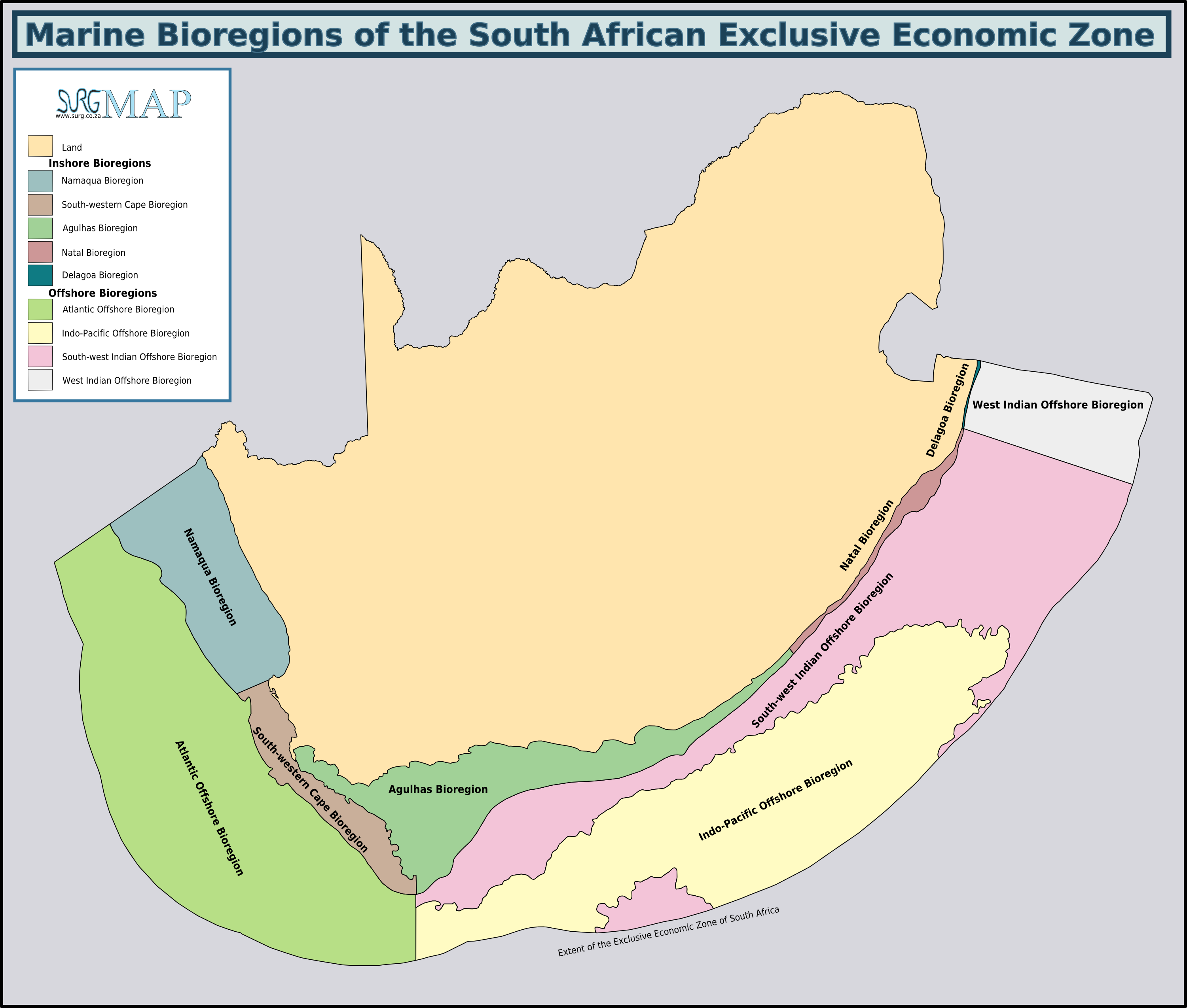
The Agulhas Bank (, from Portuguese for Cape Agulhas, ''Cabo das Agulhas'', "Cape of Needles") is a broad, shallow part of the southern African continental shelf which extends up to south of Cape Agulhas before falling steeply to the abyssal plain. It is the ocean region where the warm Indian Ocean and the cold Atlantic Ocean meet. This convergence leads to treacherous sailing conditions, accounting for numerous wrecked ships in the area over the years. However, the meeting of the oceans here also fuels the nutrient cycle for marine life, making it one of the best Fishing bank, fishing grounds in South Africa. Extent and characteristics file:Ecoregions of SA EEZ.png, South African marine ecoregions from the 2011 classification The Agulhas Bank stretches approximately along the African coast, from off Cape Peninsula (18°E) to Port Alfred (26°E), and up to from it. The bank slopes down relatively steeply from the coast to about deep and reaches before dropping steeply t ... [...More Info...] [...Related Items...] OR: [Wikipedia] [Google] [Baidu] |
Thermohaline Circulation
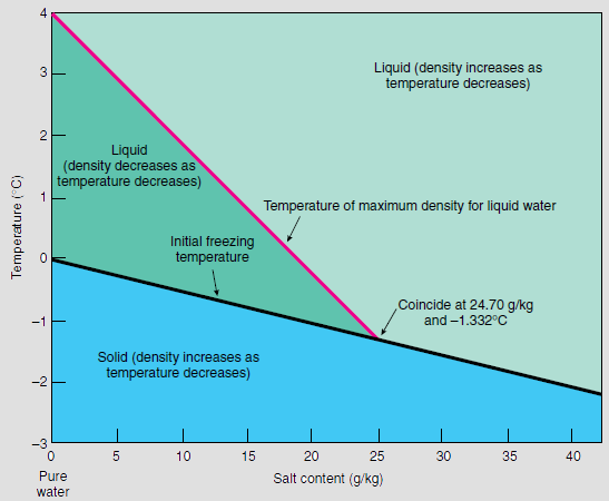
Thermohaline circulation (THC) is a part of the large-scale Ocean current, ocean circulation driven by global density gradients formed by surface heat and freshwater fluxes. The name ''thermohaline'' is derived from ''wikt:thermo-, thermo-'', referring to temperature, and ', referring to salinity, salt content—factors which together determine the Water (molecule)#Density of saltwater and ice, density of sea water. Wind-driven surface currents (such as the Gulf Stream) travel Polar regions of Earth, polewards from the equatorial Atlantic Ocean, cooling and sinking en-route to higher latitudes - eventually becoming part of the North Atlantic Deep Water - before flowing into the ocean basins. While the bulk of thermohaline water upwelling, upwells in the Southern Ocean, the oldest waters (with a transit time of approximately 1000 years) upwell in the North Pacific; extensive mixing takes place between the ocean basins, reducing the difference in their densities, forming the Worl ... [...More Info...] [...Related Items...] OR: [Wikipedia] [Google] [Baidu] |
Overberg District Municipality
The Overberg District Municipality (; ) is a district municipality that governs the Overberg region in the Western Cape province of South Africa. It is divided into four local municipalities and includes the major towns of Grabouw, Caledon, Hermanus, Bredasdorp and Swellendam. The municipal area covers and had in 2007 an estimated population of 212,787 people in 60,056 households. Geography The Overberg municipal area covers lying to the south-east of Cape Town. It stretches from the Hottentots-Holland mountains in the west to the Breede River mouth in the east, and as far as the Riviersonderend Mountains in the north. It includes Cape Agulhas, the southernmost point in Africa, and has coastline on both the Atlantic Ocean and the Indian Ocean. The largest town is Grabouw (pop. 44,593) in the Elgin Valley adjacent to the Hottentots-Holland on the north-western edge of the district. The municipal headquarters are located at Bredasdorp (pop. 12,749) in the southern part of th ... [...More Info...] [...Related Items...] OR: [Wikipedia] [Google] [Baidu] |
Cape Agulhas Local Municipality
Cape Agulhas Municipality () is a municipality located in the Western Cape province of South Africa. , it had a population of 33,038. Its municipality code is WC033. It is named after Cape Agulhas, the southernmost point of Africa. The largest town is Bredasdorp, which is the seat of the municipal headquarters. It also includes the villages of Napier, Western Cape, Napier, Struisbaai, Elim, Western Cape, Elim, Arniston, Western Cape, Arniston and L'Agulhas, and the De Hoop Nature Reserve. Geography The municipality covers an area of in the Southern Overberg, covering a radius of around Bredasdorp as well as a panhandle extending east to include the De Hoop Nature Reserve. A range of hills runs east–west through the municipality with a gap at Bredasdorp. South of these hills is the low and flat Agulhas plain. The municipality abuts on the Overstrand Municipality to the west, the Theewaterskloof Municipality to the northwest and the Swellendam Municipality to the north. Demog ... [...More Info...] [...Related Items...] OR: [Wikipedia] [Google] [Baidu] |


