|
Cameron Corner, Queensland
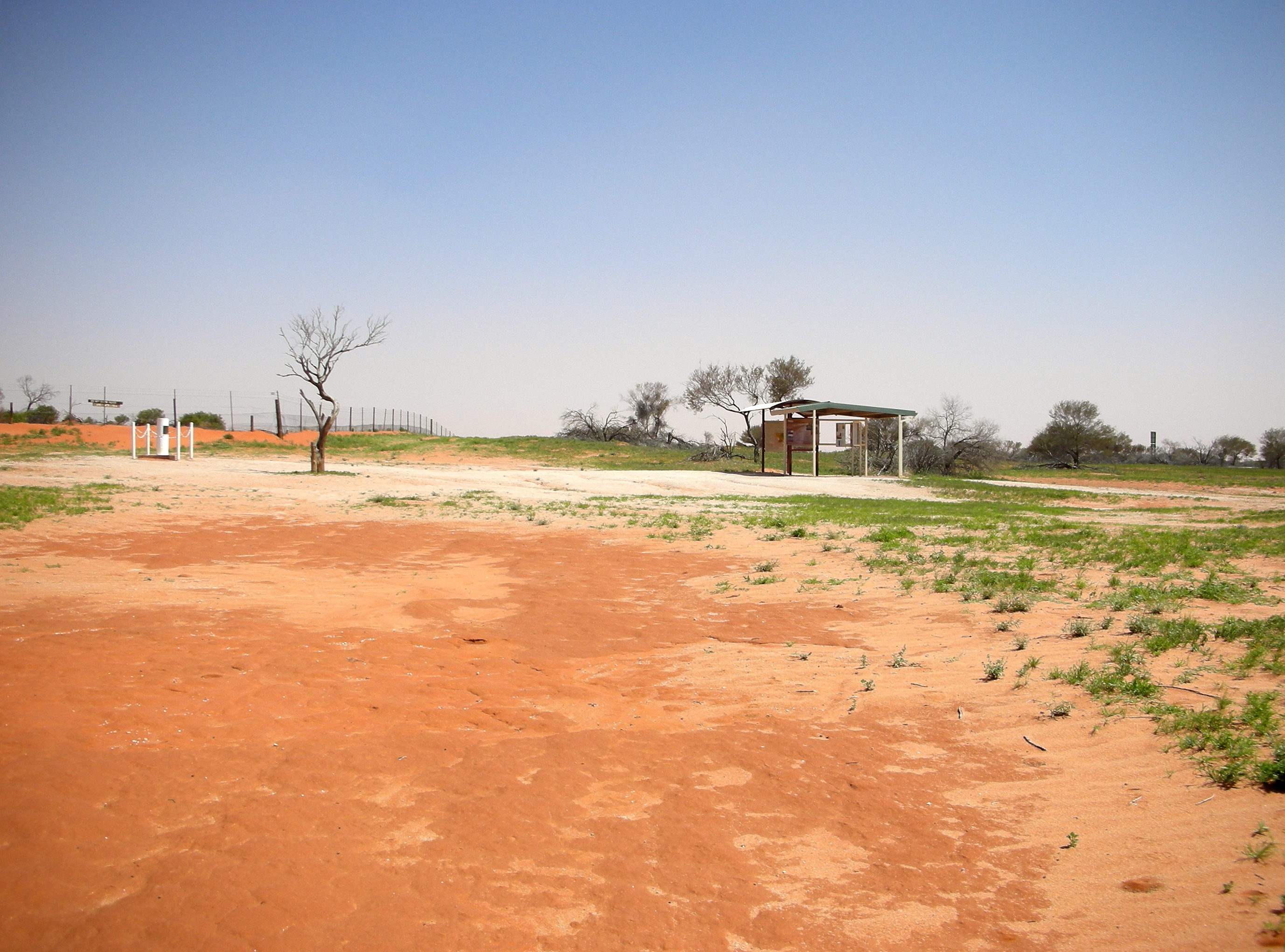
Cameron Corner is an outback locality in the Shire of Bulloo, Queensland, Australia. In the , Cameron Corner had a population of 5 people. It borders New South Wales to the south and South Australia to the west. Geography Cameron Corner is located about west-southwest of Brisbane, Queensland and is the point in the outback of eastern Australia where the boundary lines of the states of Queensland, South Australia, and New South Wales meet (the area immediately to the north and east of the intersection of the state boundaries). The noted Dingo Fence passes through Cameron Corner along the New South Wales border. Cameron Corner has the following mountains (from north to south): * Mount Intrepid () * Mount Morris () * Mount Bygrave () History This general area, which includes Sturt Stony Desert in the Lake Eyre Basin, was first explored by Captain Charles Sturt, who in 1844 went in search of a supposed inland sea in the centre of Australia. The corner and locality are na ... [...More Info...] [...Related Items...] OR: [Wikipedia] [Google] [Baidu] |
AEST
Australia uses three main time zones: Australian Western Standard Time (AWST; UTC+08:00), Australian Central Standard Time (ACST; UTC+09:30), and Australian Eastern Standard Time (AEST; UTC+10:00). Time is regulated by the individual state governments, some of which observe daylight saving time (DST). Australia's external territories observe different time zones. Standard time was introduced in the 1890s when all of the Australian colonies adopted it. Before the switch to standard time zones, each local city or town was free to determine its local time, called local mean time. Now, Western Australia uses Western Standard Time; South Australia and the Northern Territory use Central Standard Time; while New South Wales, Queensland, Tasmania, Victoria, Jervis Bay Territory, and the Australian Capital Territory use Eastern Standard Time. Daylight saving time (+1 hour) is used in jurisdictions in the south and south-east: South Australia, New South Wales, Victoria, Tasm ... [...More Info...] [...Related Items...] OR: [Wikipedia] [Google] [Baidu] |
Outback
The Outback is a remote, vast, sparsely populated area of Australia. The Outback is more remote than the bush. While often envisaged as being arid, the Outback regions extend from the northern to southern Australian coastlines and encompass a number of climatic zones, including tropical and monsoonal climates in northern areas, arid areas in the "red centre" and semi-arid and temperate climates in southerly regions. Geographically, the Outback is unified by a combination of factors, most notably a low human population density, a largely intact natural environment and, in many places, low-intensity land uses, such as pastoralism (livestock grazing) in which production is reliant on the natural environment. The Outback is deeply ingrained in Australian heritage, history and folklore. In Australian art the subject of the Outback has been vogue, particularly in the 1940s. In 2009, as part of the Q150 celebrations, the Queensland Outback was announced as one of the Q150 Icons o ... [...More Info...] [...Related Items...] OR: [Wikipedia] [Google] [Baidu] |
Cameron Corner Survey Marker
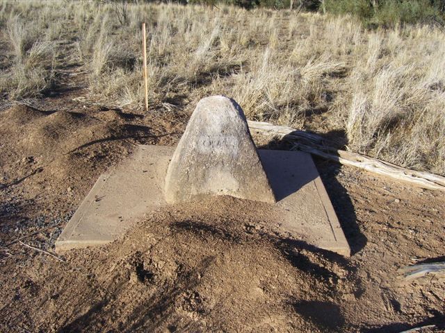
Cameron Corner Survey Marker is a heritage-listed survey marker in the locality of Cameron Corner, Shire of Bulloo, Queensland, Australia. The survey marker is at the border corner of South-West Queensland with New South Wales and South Australia; it was established in 1880. It was added to the Queensland Heritage Register on 9 November 2012. History Cameron Corner Survey Marker was established in September 1880 during the first official survey of the western section of the border between Queensland and New South Wales (NSW) undertaken in 1879-1881. It defines the westernmost extension of the Queensland-New South Wales border. Its marking was a surveying feat of its time. After debate about a suitable southern boundary for the proposed new colony to the north of New South Wales (NSW)letters patent were issued by Queen Victoria in June 1859which separated the new Colony of Queensland from NSW. The letters patent described the border between the two colonies as having thre ... [...More Info...] [...Related Items...] OR: [Wikipedia] [Google] [Baidu] |
Cameron's Corner , the heritage-listed survey mark at the geodetic point
{{disambig ...
Cameron Corner is the geodetic point at which the Australian states of Queensland, New South Wales and South Australia meet. * Cameron Corner, Queensland, the locality immediately north-east of the geodetic point * Cameron Corner Survey Marker Cameron Corner Survey Marker is a heritage-listed survey marker in the locality of Cameron Corner, Shire of Bulloo, Queensland, Australia. The survey marker is at the border corner of South-West Queensland with New South Wales and South Aust ... [...More Info...] [...Related Items...] OR: [Wikipedia] [Google] [Baidu] |
Queensland Borders
Queensland is the north-eastern state of Australia and has land borders with three other Australian states and territories: New South Wales (to the south), South Australia (to the south-west) and Northern Territory (to the west). To the north of Queensland is the Torres Strait separating the Australian mainland from Papua New Guinea. To the east of Queensland is the Coral Sea, part of the Pacific Ocean. There are many islands off the Queensland coast which form part of the state of Queensland. The far western boundary with the Northern Territory is aligned along the 138th meridian east until Poeppel Corner at the intersection of this meridian and the 26th parallel south. It is here that Queensland borders South Australia. The boundary follows this latitude until it reaches the 141st meridian east at Haddon Corner where the border turns south reaching Cameron Corner on the 29th parallel south, the most western part of the border with New South Wales. The border follows this ... [...More Info...] [...Related Items...] OR: [Wikipedia] [Google] [Baidu] |
John Brewer Cameron
John Brewer Cameron (1843 - 1897) was a geodetic surveyor in Australia. He is best known for his survey of the border between Queensland and New South Wales. He also surveyed part of the border between South Australia and Western Australia. Early life John Brewer Cameron was born on 31 December 1843 in Kilmonivaig, Inverness, Scotland. Border between Queensland and New South Wales Between 1879 and 1881 the official survey of the 29ºS parallel border between Queensland and New South Wales was conducted by Cameron (employed by the New South Wales Government) and George Chale Watson (employed by the Queensland Government). Astronomical observations were taken at the Barringun telegraph station to determine the latitude and longitude. Following these observations, the Zero Obelisk was erected on the banks of the Warrego River, just north of the town of Barringun. From this mark, the first 5-mile chord was produced westerly and the mile posts offset from this chord to the ... [...More Info...] [...Related Items...] OR: [Wikipedia] [Google] [Baidu] |
Inland Sea (geology)
An inland sea (also known as an epeiric sea or an epicontinental sea) is a continental body of water which is very large and is either completely surrounded by dry land or connected to an ocean by a river, strait, or "arm of the sea". An inland sea will generally have higher salinity than a freshwater lake, but usually lower salinity than the open ocean. Definition What constitutes an "inland sea" is complex and somewhat necessarily vague. The United States Hydrographic Office defined it as "a body of water nearly or completely surrounded by land, especially if very large or composed of salt water". Geologic engineers Heinrich Ries and Thomas L. Watson say an inland sea is merely a very large lake. Rydén, Migula, and Andersson and Deborah Sandler of the Environmental Law Institute add that an inland sea is "more or less" cut off from the ocean. It may be semi-enclosed, or connected to the ocean by a strait or "arm of the sea". An inland sea is distinguishable from a bay in th ... [...More Info...] [...Related Items...] OR: [Wikipedia] [Google] [Baidu] |
Charles Sturt
Charles Napier Sturt (28 April 1795 – 16 June 1869) was a British officer and explorer of Australia, and part of the European exploration of Australia. He led several expeditions into the interior of the continent, starting from Sydney and later from Adelaide. His expeditions traced several of the westward-flowing rivers, establishing that they all merged into the Murray River, which flows into the Southern Ocean. He was searching to prove his own passionately held belief that an "inland sea" was located at the centre of the continent. He reached the rank of Captain, served in several appointed posts, and on the Legislative Council. Born to British parents in Bengal, British India, Sturt was educated in England for a time as a child and youth. He was placed in the British Army because his father was not wealthy enough to pay for Cambridge. After assignments in North America, Sturt was assigned to accompany a ship of convicts to Australia in 1827. Finding the place to his li ... [...More Info...] [...Related Items...] OR: [Wikipedia] [Google] [Baidu] |
Lake Eyre Basin
The Lake Eyre basin ( ) is a drainage basin that covers just under one-sixth of all Australia. It is the largest endorheic basin in Australia and amongst the largest in the world, covering about , including much of inland Queensland, large portions of South Australia and the Northern Territory, and a part of western New South Wales. The basin is also one of the largest, least-developed arid zone basins with a high degree of variability anywhere. It supports only about 60,000 people and has no major irrigation, diversions or flood-plain developments. Low density grazing that sustains a large amount of wildlife is the major land use, occupying 82% of the total land within the basin. The Lake Eyre basin of precipitation (rain water) to a great extent geographically overlaps the Great Artesian Basin underneath. The basin began as a sinking landmass mostly covered by forest and contained many more lakes than now. The climate has changed from wet to arid over the last 60 million year ... [...More Info...] [...Related Items...] OR: [Wikipedia] [Google] [Baidu] |
Sturt Stony Desert
Sturt Stony Desert (previously Sturt's Stony Desert) is an area in the north-east of South Australia, far south western border area of Queensland and the far west of New South Wales. It was named by Charles Sturt in 1844, while he was trying to find the inland sea which he believed lay at the centre of Australia. The stones caused his horses to limp and wore down the hooves of the cattle and sheep which Sturt had taken on the expedition. The larger Simpson Desert is located to the west and the Strzelecki Desert is to the south east. Between these two dunefields is the Gason Dome, upon which the Sturt Stony Desert is located. To the south west of Sturt Stony Desert is the Tirari Desert. The Birdsville Track is a route between Marree in South Australia and Birdsville in Queensland. Landscape Much of the desert is covered by gibber. Sturt suggested the closely compacted stones were the result of currents moving across an ancient seafloor. However the gibber plains orig ... [...More Info...] [...Related Items...] OR: [Wikipedia] [Google] [Baidu] |
Queensland Government
The Queensland Government is the democratic administrative authority of the Australian state of Queensland. The Government of Queensland, a parliamentary constitutional monarchy was formed in 1859 as prescribed in its Constitution, as amended from time to time. Since the Federation of Australia in 1901, Queensland has been a State of Australia, with the Constitution of Australia regulating the relationships between all state and territory governments and the Australian Government. Under the Australian Constitution, all states and territories (including Queensland) ceded powers relating to certain matters to the federal government. The government is influenced by the Westminster system and Australia's federal system of government. The Governor of Queensland, as the representative of Charles III, King of Australia, holds nominal executive power, although in practice only performs ceremonial duties. In practice executive power lies with the Premier and Cabinet. The Cabinet ... [...More Info...] [...Related Items...] OR: [Wikipedia] [Google] [Baidu] |


