|
Buise
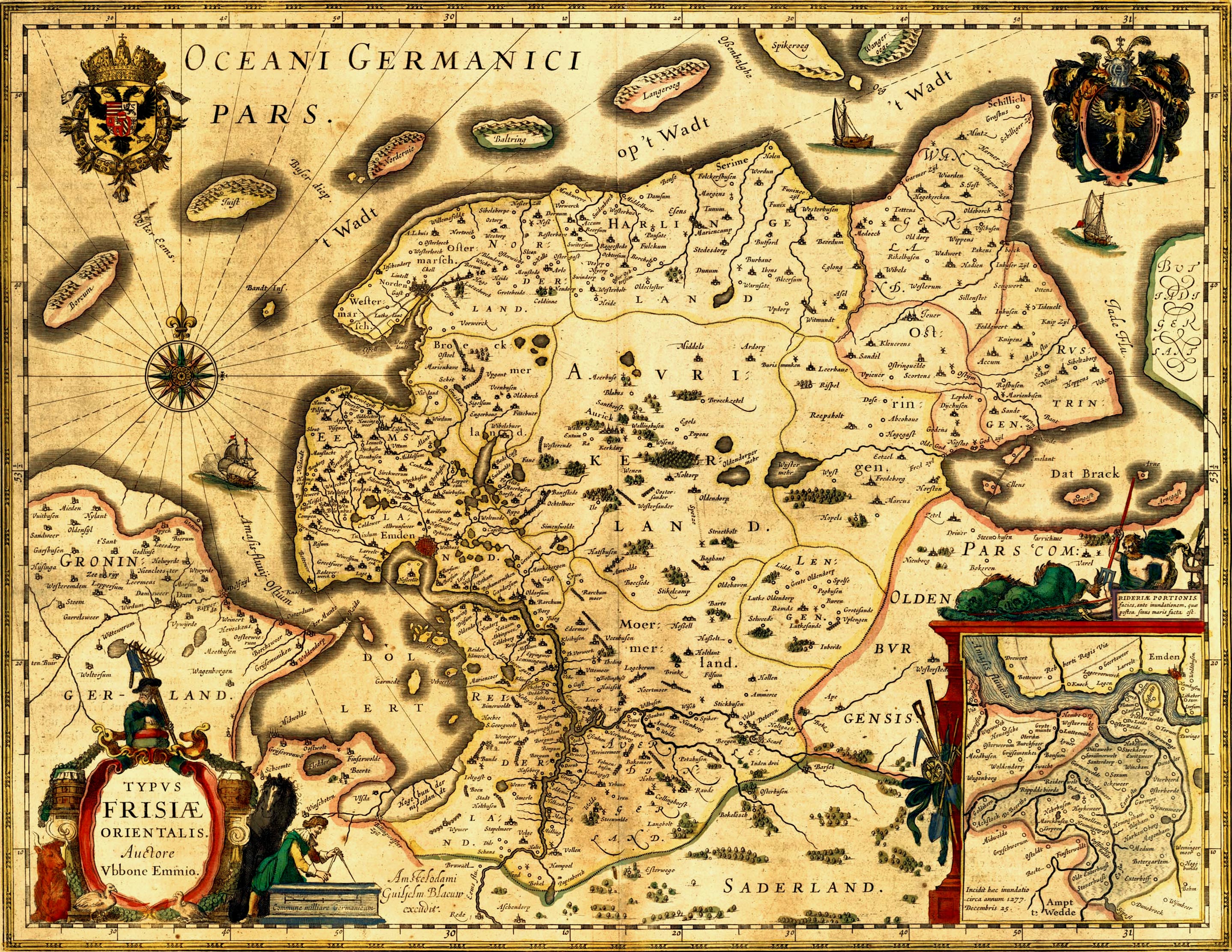
Buise was one of the East Frisian Islands off the North Sea coast of Germany that was almost entirely engulfed by the sea in the second half of the 17th century. The only remaining part is the eastern end, known today as the island of Norderney. Buise itself was formed by the breakup of a bigger island. Two possible origins are mentioned: the breakup of the island Burchana in the flood of 1219, and the breakup of the island Bant in 1170, which also formed Juist, Borkum and Memmert. Buise broke up in two parts in 1362. The eastern part was called Osterende initially, and later "Norder neye Oog" (Nordens New Island), and today is the island Norderney Norderney ( nds, Nördernee) is one of the seven populated East Frisian Islands off the North Sea coast of Germany. The island is , having a total area of about and is therefore Germany's ninth-largest island. Norderney's population amounts .... The western part disappeared slowly over the ages as a result of erosion, but sour ... [...More Info...] [...Related Items...] OR: [Wikipedia] [Google] [Baidu] |
Norderney
Norderney ( nds, Nördernee) is one of the seven populated East Frisian Islands off the North Sea coast of Germany. The island is , having a total area of about and is therefore Germany's ninth-largest island. Norderney's population amounts to about 5,850 people. In 1946 Norderney gained municipal status and belongs to the Aurich "Kreis" (county). On the northern side of the island lies a long sandy beach. The neighbouring island to the east is Baltrum, which lies about 800m (half a mile) away beyond the Wichter Ee. To the west is the island of Juist, about away on the other side of the Norderneyer Seegatt. The entire eastern half of Norderney belongs to the Lower Saxon Wadden Sea National Park. Access to the park is restricted, as it is subdivided in zones of different accessibility for the protection of the wildlife. The status as a National Park also affects all types of traffic on the island, while especially car traffic is subject to strict regulations. The mainla ... [...More Info...] [...Related Items...] OR: [Wikipedia] [Google] [Baidu] |
East Frisian Islands
The East Frisian Islands (German: ''Ostfriesische Inseln'', West Frisian: ''Eastfryske eilannen'', stq, Aastefräiske Ailounds) are a chain of islands in the North Sea, off the coast of East Frisia in Lower Saxony, Germany. The islands extend for some from west to east between the mouths of the Ems and Jade / Weser rivers and lie about 3.5 to 10 km offshore. Between the islands and the mainland are extensive mudflats, known locally as ''Watten'', which form part of the Wadden Sea. In front of the islands are Germany's territorial waters, which occupy a much larger area than the islands themselves. The islands, the surrounding mudflats and the territorial waters (The ''Küstenmeer vor den ostfriesischen Inseln'' nature reserve) form a close ecological relationship. The island group makes up about 5% of the Lower Saxony Wadden Sea National Park. The largest island by surface area is Borkum, located at the western end of the chain; the other six inhabited islands are from ... [...More Info...] [...Related Items...] OR: [Wikipedia] [Google] [Baidu] |
North Sea
The North Sea lies between Great Britain, Norway, Denmark, Germany, the Netherlands and Belgium. An epeiric sea, epeiric sea on the European continental shelf, it connects to the Atlantic Ocean through the English Channel in the south and the Norwegian Sea in the north. It is more than long and wide, covering . It hosts key north European shipping lanes and is a major fishery. The coast is a popular destination for recreation and tourism in bordering countries, and a rich source of energy resources, including wind energy, wind and wave power. The North Sea has featured prominently in geopolitical and military affairs, particularly in Northern Europe, from the Middle Ages to the modern era. It was also important globally through the power northern Europeans projected worldwide during much of the Middle Ages and into the modern era. The North Sea was the centre of the Viking Age, Vikings' rise. The Hanseatic League, the Dutch Golden Age, Dutch Republic, and the Kingdom of Grea ... [...More Info...] [...Related Items...] OR: [Wikipedia] [Google] [Baidu] |
Bant(island)
Bant is one of the so-called green villages ''(Dutch: groendorpen)'' in the Dutch province of Flevoland. It is a part of the municipality of Noordoostpolder, and lies about 7 km north of Emmeloord. Name The name Bant is derived from the estates of ''Bant'' or ''Bantega'', which at one point existed in what is now the municipality of De Fryske Marren, and extended into the area that is now the Noordoostpolder. History Prison camp After World War II, before the founding of Bant, the site was used as a prisoner camp for Nazi-collaborators under the name ''Kamp Westvaart''. The camp was accommodated with watchtowers and armed guards. Several prominent collaborators served sentences in the camp. Jan Gunnink, former head of the KP-Meppel, a prominent resistance movement during the war, served as camp commander. The camp was subject of a social experiment, in which prisoners were offered a contract in which they declared they would not resist and fight in exchange for free ... [...More Info...] [...Related Items...] OR: [Wikipedia] [Google] [Baidu] |
Juist
Juist () ( nds, Juist) is an island and municipality in the district of Aurich in Lower Saxony in Germany. The island is one of seven East Frisian Islands at the edge of the Lower Saxon Wadden Sea in the southern North Sea. It is located between Borkum Island (west), Memmert Island (southwest) and Norderney (east). The island is long and from to wide, depending on the tide levels. There are two villages on the island: the main village Juist, and Loog. The island is separated from Norderney by the Norderneyer Seegatt. Overview and geography The tallest buildings on Juist that can be seen from the North Sea are the water tower and an old hotel. There is a lighthouse on the island, but it is not in use. At the western end of the island is the Billreef, a large sandbank where birds such as dunlins, grey plovers and knots rest during their migration. In the western part of the island the beach and the dunes are eroded by the sea. The edge of the dunes moves about five metres so ... [...More Info...] [...Related Items...] OR: [Wikipedia] [Google] [Baidu] |
Borkum
Borkum ( nds, Borkum, Börkum) is an island and a municipality in the Leer District in Lower Saxony, northwestern Germany. It is situated east of Rottumeroog and west of Juist. Geography Borkum is bordered to the west by the Westerems strait (which forms the border with the Netherlands), to the east by the Osterems strait, to the north by the North Sea, and to the south by the Wadden Sea. It is the largest and westernmost of the East Frisian Islands in the North Sea, due north of the Dutch province of Groningen. The island was formed in 1863 by two previously separate islands which were still separated by a shallow water. The seam between the former eastern and western parts is called ''Tüskendör'' ("through in between"). Climate Borkum is the only East Frisian island that is under the influence of the North Sea all year round thanks to its distance from the mainland. The maritime climate is influenced by the Gulf Stream and the west wind zone with correspondingly high ... [...More Info...] [...Related Items...] OR: [Wikipedia] [Google] [Baidu] |
Memmert
Memmert is a small East Frisian island off the northern coast of Germany, with an area of . Memmert is uninhabited, with only one house on the island for wildlife-spotting purposes. Occasionally, some guests from the neighboring islands visit Memmert for recreation. Memmert is officially a wildlife protected area. The island plays an important role in Erskine Childers's novel ''The Riddle of the Sands ''The Riddle of the Sands: A Record of Secret Service'' is a 1903 novel by Erskine Childers. The book, which enjoyed immense popularity in the years before World War I, is an early example of the espionage novel and was extremely influenti ...'' (1903). Notable people * References External links East Frisian Islands Islands of Lower Saxony Uninhabited islands of Germany {{germany-island-stub ... [...More Info...] [...Related Items...] OR: [Wikipedia] [Google] [Baidu] |
Former Islands Of Germany
A former is an object, such as a template, gauge or cutting die, which is used to form something such as a boat's hull. Typically, a former gives shape to a structure that may have complex curvature. A former may become an integral part of the finished structure, as in an aircraft fuselage, or it may be removable, being using in the construction process and then discarded or re-used. Aircraft formers Formers are used in the construction of aircraft fuselage, of which a typical fuselage has a series from the nose to the empennage, typically perpendicular to the longitudinal axis of the aircraft. The primary purpose of formers is to establish the shape of the fuselage and reduce the column length of stringers to prevent instability. Formers are typically attached to longerons, which support the skin of the aircraft. The "former-and-longeron" technique (also called stations and stringers) was adopted from boat construction, and was typical of light aircraft built until the ... [...More Info...] [...Related Items...] OR: [Wikipedia] [Google] [Baidu] |
History Of East Frisia
The history of East Frisia developed rather independently from the rest of Germany because the region was relatively isolated for centuries by large stretches of bog to the south, while at the same time its people were oriented towards the sea. Thus in East FrisiaThis article focusses on the historic region of East Frisia, which today comprises the town of Emden as well as the counties of Aurich, Leer and Wittmund; see the definition of the East Frisian landscapeStatute of the East Frisian Landscape Article I (Principles), Paragraph 2: "East Frisia includes the municipalities of Aurich, Leer and Wittmund as well as town of Emden." in the Middle Ages there was little feudalism, instead a system of fellowship under the so-called Friesian Freedom emerged. It was not until 1464, that the House of Cirksena was enfeoffed with the Imperial County of East Frisia. Nevertheless absolutism had been, and continued to be, unknown in East Frisia. In the two centuries after about 1500, the inf ... [...More Info...] [...Related Items...] OR: [Wikipedia] [Google] [Baidu] |


.png)

