|
Brockley, Suffolk
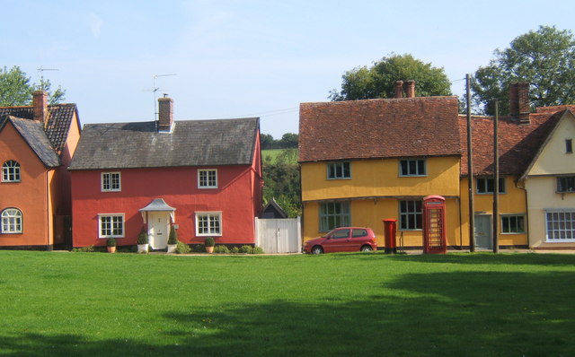
Brockley ''(not to be confused with Brockley Green, southwest in Hundon parish)'' is a village and civil parish in the West Suffolk district of Suffolk, England. Brockley parish includes the hamlets of Pound Green and Gulling Green. According to the 2001 Census parish population was 281, and increased to 312 at the 2011 Census. The village is situated approximately south of Bury St Edmunds and north of Sudbury on the B1066. Also it is north of Hartest. A small hamlet is recorded in Domesday as "Brochola" or "Broclega": the name originates from 'woodland clearing by a brook'. Mill Road marks the location of a former post mill which was demolished in 1930. East of B1066 is Willow Tree Farm (now Britton's Farm) (farthest out) with a small chapel (halfway to B1066). West of B1066 is Mile Farm (now Long's Farm) with the Pumping Station farthest west. Brockley Hall and St Andrew's Church are still around 1 km north of the village. St Andrew's dates from medieval times bu ... [...More Info...] [...Related Items...] OR: [Wikipedia] [Google] [Baidu] |
West Suffolk (district)
West Suffolk District is a Non-metropolitan district, local government district in Suffolk, England. It was established in 2019 as a merger of the previous Forest Heath District with the Borough of St Edmundsbury. The council is based in Bury St Edmunds, the district's largest town. The district also contains the towns of Brandon, Suffolk, Brandon, Clare, Suffolk, Clare, Haverhill, Suffolk, Haverhill, Mildenhall, Suffolk, Mildenhall and Newmarket, Suffolk, Newmarket, along with numerous villages and surrounding rural areas. In 2021 it had a population of 180,820. The neighbouring districts are Mid Suffolk, Babergh District, Babergh, Braintree District, Braintree, South Cambridgeshire, East Cambridgeshire, King's Lynn and West Norfolk and Breckland District, Breckland. History Prior to West Suffolk's creation, its predecessors Forest Heath District Council and St Edmundsbury Borough Council had been working together for a number of years, having shared a joint chief executive si ... [...More Info...] [...Related Items...] OR: [Wikipedia] [Google] [Baidu] |
Suffolk
Suffolk ( ) is a ceremonial county in the East of England and East Anglia. It is bordered by Norfolk to the north, the North Sea to the east, Essex to the south, and Cambridgeshire to the west. Ipswich is the largest settlement and the county town. The county has an area of and a population of 758,556. After Ipswich (144,957) in the south, the largest towns are Lowestoft (73,800) in the north-east and Bury St Edmunds (40,664) in the west. Suffolk contains five Non-metropolitan district, local government districts, which are part of a two-tier non-metropolitan county administered by Suffolk County Council. The Suffolk coastline, which includes parts of the Suffolk & Essex Coast & Heaths National Landscape, is a complex habitat, formed by London Clay and Crag Group, crag underlain by chalk and therefore susceptible to erosion. It contains several deep Estuary, estuaries, including those of the rivers River Blyth, Suffolk, Blyth, River Deben, Deben, River Orwell, Orwell, River S ... [...More Info...] [...Related Items...] OR: [Wikipedia] [Google] [Baidu] |
Hundon
Hundon is a village and civil parish in the West Suffolk district in Suffolk, England. The village is about north-west of the small town of Clare Clare may refer to: Places Antarctica * Clare Range, a mountain range in Victoria Land Australia * Clare, South Australia, a town in the Clare Valley * Clare Valley, South Australia Canada * Clare (electoral district), an electoral district * Cl ..., and from the larger town of Haverhill, and includes a primary school, post office, a village hall, the Rose & Crown public house, and All Saints Parish Church. At the south-west of the parish is the hamlet of Brockley Green which includes two farms and The Plough Inn public house. References External links Hundon VillageHundon School Villages in Suffolk Civil parishes in Suffolk Borough of St Edmundsbury {{suffolk-geo-stub ... [...More Info...] [...Related Items...] OR: [Wikipedia] [Google] [Baidu] |
Civil Parish
In England, a civil parish is a type of administrative parish used for local government. It is a territorial designation which is the lowest tier of local government. Civil parishes can trace their origin to the ancient system of parishes, which for centuries were the principal unit of secular and religious administration in most of England and Wales. Civil and religious parishes were formally split into two types in the 19th century and are now entirely separate. Civil parishes in their modern form came into being through the Local Government Act 1894 ( 56 & 57 Vict. c. 73), which established elected parish councils to take on the secular functions of the parish vestry. A civil parish can range in size from a sparsely populated rural area with fewer than a hundred inhabitants, to a large town with a population in excess of 100,000. This scope is similar to that of municipalities in continental Europe, such as the communes of France. However, unlike their continental Euro ... [...More Info...] [...Related Items...] OR: [Wikipedia] [Google] [Baidu] |
Bury St Edmunds
Bury St Edmunds (), commonly referred to locally as ''Bury,'' is a cathedral as well as market town and civil parish in the West Suffolk District, West Suffolk district, in the county of Suffolk, England.OS Explorer map 211: Bury St. Edmunds and Stowmarket Scale: . Publisher:Ordnance Survey – Southampton A2 edition. Publishing Date:2008. The town is best known for Bury St Edmunds Abbey and St Edmundsbury Cathedral. Bury is the seat of the Diocese of St Edmundsbury and Ipswich of the Church of England, with the episcopal see at St Edmundsbury Cathedral. The town, originally called Beodericsworth, was built on a grid pattern by Abbot Baldwin around 1080. It is known for brewing and malting (Greene King brewery) and for a British Sugar processing factory, where Silver Spoon sugar is produced. The town is the cultural and retail centre for West Suffolk and tourism is a major part of the economy. The built up area had a population of 41,280 at the 2021 United Kingdom census, 2021 c ... [...More Info...] [...Related Items...] OR: [Wikipedia] [Google] [Baidu] |
Sudbury, Suffolk
Sudbury (, ) is a market town and civil parish in the south west of Suffolk, England, on the River Stour near the Essex border, north-east of London. It is the largest town in the Babergh local government district and part of the South Suffolk constituency. In 2021, the built-up area had a population of 23,912 and the parish had a population of 13,619. Sudbury was an Anglo-Saxon settlement from the end of the 8th century, and its market was established in the early 11th century. Its textile industries prospered in the Late Middle Ages, the wealth of which funded many of its buildings and churches. The town became notable for its art in the 18th century, being the birthplace of Thomas Gainsborough, whose landscapes offered inspiration to John Constable, another Suffolk painter of the surrounding Stour Valley area. The 19th century saw the arrival of the railway with the opening of a station on the historic Stour Valley Railway, and Sudbury railway station forms the curren ... [...More Info...] [...Related Items...] OR: [Wikipedia] [Google] [Baidu] |
Hartest
Hartest is a small village and civil parish in the Babergh district of the English county of Suffolk. It is located halfway between Bury St. Edmunds and Sudbury on the B1066 road in the Glem valley. Brockley is two miles north. The village of Hartest dates back to before 1086 and features in the Domesday Book. The name 'Hartest' is thought to mean either 'Stag Hill' or 'Stag Wood'. It is claimed that there are no other villages, towns or cities in the world of the same name. The village is centred on the large village green, fringed by an array of brightly coloured cottages, the village hall or institute, the medieval All Saints church and the Crown public house, formerly Hartest Hall the local landowner's seat. There is an annual fete held on the village green at the end of August each year. Running east of the village centre is Hartest Hill, the steepest in Suffolk. Former Special Envoy for the Archbishop of Canterbury and Islamic Jihad Organization hostage, Terry Wai ... [...More Info...] [...Related Items...] OR: [Wikipedia] [Google] [Baidu] |
Public House
A pub (short for public house) is in several countries a drinking establishment licensed to serve alcoholic drinks for consumption Licensing laws of the United Kingdom#On-licence, on the premises. The term first appeared in England in the late 17th century, to differentiate private houses from those open to the public as alehouses, taverns and inns. Today, there is no strict definition, but the Campaign for Real Ale (CAMRA) states a pub has four characteristics: # is open to the public without membership or residency # serves draught beer or cider without requiring food be consumed # has at least one indoor area not laid out for meals # allows drinks to be bought at a bar (i.e., not only table service) The history of pubs can be traced to taverns in Roman Britain, and through Anglo-Saxon alehouses, but it was not until the early 19th century that pubs, as they are today, first began to appear. The model also became popular in countries and regions of British influence, whe ... [...More Info...] [...Related Items...] OR: [Wikipedia] [Google] [Baidu] |
Villages In Suffolk
A village is a human settlement or community, larger than a hamlet but smaller than a town with a population typically ranging from a few hundred to a few thousand. Although villages are often located in rural areas, the term urban village is also applied to certain urban neighborhoods. Villages are normally permanent, with fixed dwellings; however, transient villages can occur. Further, the dwellings of a village are fairly close to one another, not scattered broadly over the landscape, as a dispersed settlement. In the past, villages were a usual form of community for societies that practice subsistence agriculture and also for some non-agricultural societies. In Great Britain, a hamlet earned the right to be called a village when it built a church.Dr Greg Stevenson, "Wha ... [...More Info...] [...Related Items...] OR: [Wikipedia] [Google] [Baidu] |
Civil Parishes In Suffolk
Civil may refer to: *Civility, orderly behavior and politeness *Civic virtue, the cultivation of habits important for the success of a society *Civil (journalism) ''The Colorado Sun'' is an online news outlet based in Denver, Colorado. It launched on September 10, 2018, to provide long-form, in-depth coverage of news from all around Colorado. It was started with two years of funding from blockchain ventu ..., a platform for independent journalism * Civil (surname) See also * {{Disambiguation ... [...More Info...] [...Related Items...] OR: [Wikipedia] [Google] [Baidu] |


