|
Bintuni Bay
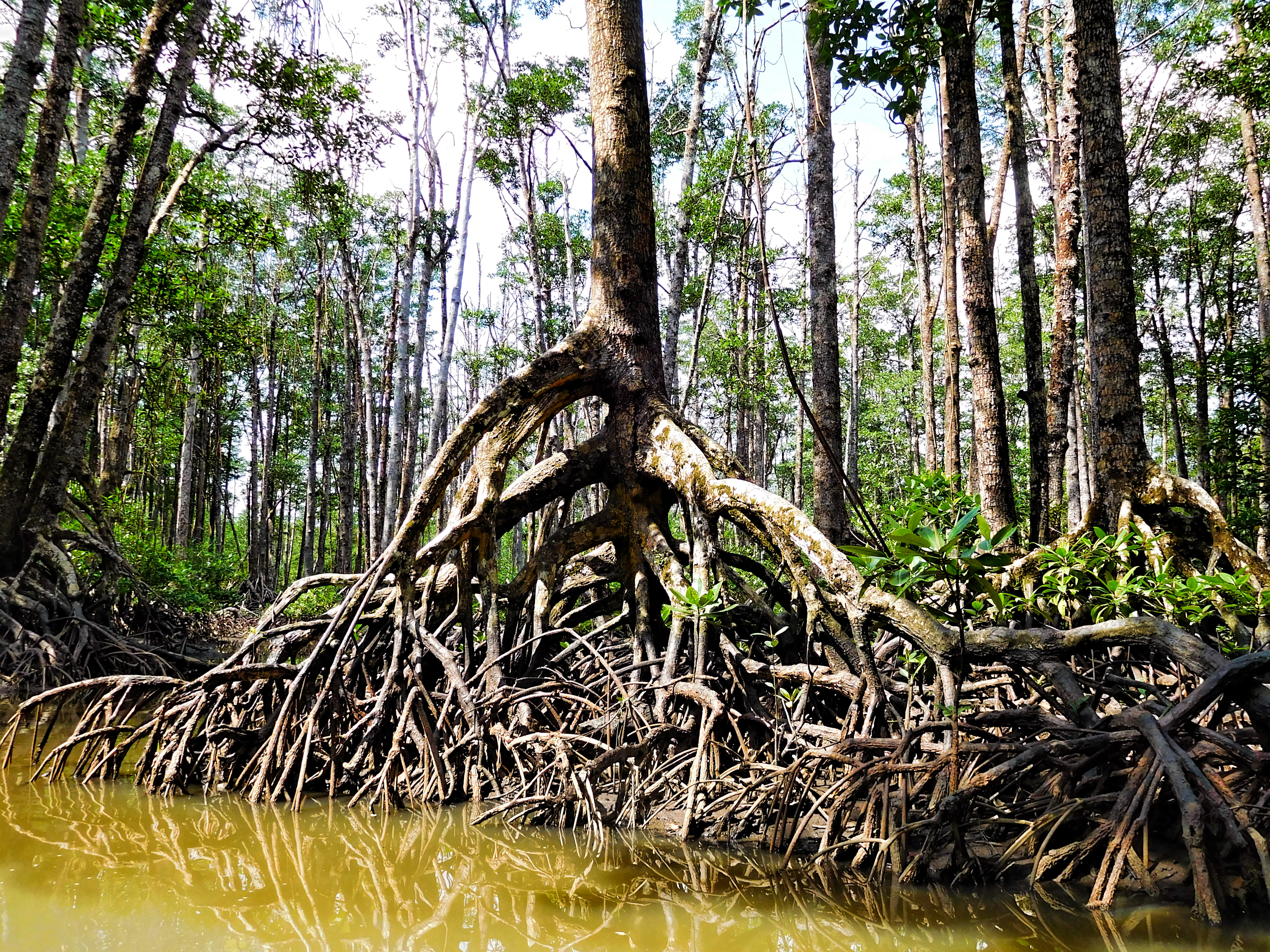
Bintuni Bay () is the eastward extension or inner bay of Berau Gulf in western New Guinea. It separates the Bird's Head Peninsula on the north from the Bomberai Peninsula on the south. Administratively it is part of West Papua, Indonesia. The bay is wide at its entrance and there are extensive marshes along the shore. Bintuni Bay is located on the Southern end of the Bird's Head Peninsula in West Papua, Indonesia. The bay is elongated with a total length of 160km and 70km wide at the mouth. Bintuni Bay is the inner bay with extensive river and mangrove habitats, known for one of the largest contiguous mangrove forests in the world, covering approximately 300,000 hectares of area on land and another 600,000 hectares to the 10m water depth. Mangrove forests play an important role in the ecosystem because they serve as a habitat for various types of animals, including birds, fish, and other marine biota. Mangrove forests in Bintuni Bay also serve as natural protection from coasta ... [...More Info...] [...Related Items...] OR: [Wikipedia] [Google] [Baidu] [Amazon] |
Western New Guinea
Western New Guinea, also known as Papua, Indonesian New Guinea, and Indonesian Papua, is the western half of the island of New Guinea, formerly Dutch and granted to Indonesia in 1962. Given the island is alternatively named Papua, the region is also called West Papua (). It is one of the seven geographical units of Indonesia in ISO 3166-2:ID. Lying to the west of Papua New Guinea and geographically a part of the Australian continent, the territory is almost entirely in the Southern Hemisphere and includes the Biak and Raja Ampat archipelagoes. The region is predominantly covered with rainforest where traditional peoples live, including the Dani of the Baliem Valley. A large proportion of the population live in or near coastal areas. The largest city is Jayapura. The island of New Guinea has been populated for tens of thousands of years. European traders began frequenting the region around the late 16th century due to spice trade. In the end, the Dutch Empire emerged ... [...More Info...] [...Related Items...] OR: [Wikipedia] [Google] [Baidu] [Amazon] |
Berau Gulf
The Berau Gulf (), formerly the MacCleur Gulf, separates the Vogelkop (Doberai) and Bomberai Peninsulas of Western New Guinea. It opens on the Ceram Sea to the west and ends in Bintuni Bay to the east. Geography Berau Bay is formed by the broadening of Bintuni Bay to the east and separates the Vogelkop Peninsula to the north from the Bomberai Peninsula (with its western extremity, the Fakfak Peninsula) to the south. To the west is the open Seram Sea. The islands of Ogar and Arguni are located off the Fakfak peninsula. The area is part of the Indonesian province of Papua Barat. The administrative district of Fakfak lies on the southern coast, while the northern coast (the southern coast of the Vogelkop) belongs to the administrative districts of Teluk Bintuni and Sorong Selatan (South Sorong).Der große Weltatlas, Millenium House, 2009, . See also *Berau Gulf languages The Berau Gulf languages form a high-level branch of the Trans–New Guinea language family in the ... [...More Info...] [...Related Items...] OR: [Wikipedia] [Google] [Baidu] [Amazon] |
World Database On Protected Areas
The World Database on Protected Areas (WDPA) is the largest assembly of data on the world's terrestrial and marine protected areas, containing more than 260,000 protected areas as of August 2020, with records covering 245 countries and territories throughout the world. The WDPA is a joint venture between the United Nations Environment Programme World Conservation Monitoring CentreUNEP-WCMC and the International Union for Conservation of NatureIUCN World Commission on Protected AreasWCPA. Data for the WDPA is collected from international convention secretariats, governments and collaborating NGOs, but the role of custodian is allocated to the Protected Areas Programme of UNEP-WCMC, based in Cambridge, UK, who have hosted the database since its creation in 1981. The WDPA delivers invaluable information to decision-makers around the world, particularly in terms of measuring the extent and effectiveness of protected areas as an indicator for meeting global biodiversity targets. In Oc ... [...More Info...] [...Related Items...] OR: [Wikipedia] [Google] [Baidu] [Amazon] |
New Guinea
New Guinea (; Hiri Motu: ''Niu Gini''; , fossilized , also known as Papua or historically ) is the List of islands by area, world's second-largest island, with an area of . Located in Melanesia in the southwestern Pacific Ocean, the island is separated from Mainland Australia, Australia by the wide Torres Strait, though both landmasses lie on the same continental shelf, and were united during episodes of low sea level in the Pleistocene glaciations as the combined landmass of Sahul. Numerous smaller islands are located to the west and east. The island's name was given by Spanish explorer Yñigo Ortiz de Retez during his maritime expedition of 1545 due to the perceived resemblance of the indigenous peoples of the island to those in the Guinea (region), African region of Guinea. The eastern half of the island is the major land mass of the nation of Papua New Guinea. The western half, known as Western New Guinea, forms a part of Indonesia and is organized as the provinces of Pap ... [...More Info...] [...Related Items...] OR: [Wikipedia] [Google] [Baidu] [Amazon] |
Bird's Head Peninsula
The Bird's Head Peninsula ( Indonesian: , , meaning Bird's Head in Indonesian and Dutch) or Doberai Peninsula (''Semenanjung Doberai'') is a large peninsula that makes up the northwest portion of the island of New Guinea, comprising the Indonesian provinces of Southwest Papua and West Papua. It is often referred to as The Vogelkop, and is so named because its shape looks like a bird's head on the island of New Guinea. The peninsula at the opposite end of the island (in Papua New Guinea) is called the Bird's Tail Peninsula. The peninsula just to the south is called the Bomberai Peninsula. Location and geography The Bird's Head Peninsula is at the northwestern end of the island of New Guinea. It is bounded by Cenderawasih Bay to the east, Bintuni Bay to the south, and the Dampier Strait to the west. Across the strait is Waigeo, an island in the Raja Ampat archipelago. Batanta island lies just off the peninsula’s northwest tip. Another peninsula, Bomberai Peninsula, l ... [...More Info...] [...Related Items...] OR: [Wikipedia] [Google] [Baidu] [Amazon] |
Bomberai Peninsula
Bomberai Peninsula () is located in the Western New Guinea region. It is south of the Bird's Head Peninsula, and Bintuni Bay separates the two peninsulas. To the west lies the Sebakor Bay and to the south Kamrau Bay. On the southeast Arguni Bay lies between the peninsula and the Bird's Neck Isthmus. Sabuda island lies off the western tip of the peninsula, and is separated from the mainland by Berau and Bintuni straits. Geography The entire peninsula is covered by a dense tropical rainforest. Most of the peninsula consists of a marshy plain, covered in lowland rainforest. There are smaller areas of montane rainforest in the Fakfak and Kumawa mountains along the peninsula's western edge. Together with the eastern region of Bird's Head Peninsula and offshore islands, the Bomberai Peninsula forms the Indonesian province of West Papua (). The western part of the peninsula is part of Fakfak Regency, the north belongs to Teluk Bintuni Regency and the southeast to Kaiman ... [...More Info...] [...Related Items...] OR: [Wikipedia] [Google] [Baidu] [Amazon] |
West Papua (province)
West Papua (), formerly Irian Jaya Barat (West Irian), is an Indonesian Provinces of Indonesia, province located in Indonesia Western New Guinea, Papua. It covers most of the two western peninsulas of the island of New Guinea: the eastern half of the Bird's Head Peninsula (or Doberai Peninsula) and the whole of the Bomberai Peninsula, along with nearby smaller islands. The province is bordered to the north by the Pacific Ocean, to the west by Southwest Papua Province, the Halmahera Sea and the Ceram Sea, to the south by the Banda Sea, and to the east by the province of Central Papua and the Cenderawasih Bay. Manokwari is the province's capital and largest city. With an estimated population of 578,700 in mid-2024 (comprising 304,140 males and 274,560 females), West Papua is the second-least-populous province in Indonesia after South Papua, following the separation off in December 2022 of the western half of the Bird's Head Peninsula to create the new province of Southwest Papua, ... [...More Info...] [...Related Items...] OR: [Wikipedia] [Google] [Baidu] [Amazon] |
Indonesia
Indonesia, officially the Republic of Indonesia, is a country in Southeast Asia and Oceania, between the Indian Ocean, Indian and Pacific Ocean, Pacific oceans. Comprising over List of islands of Indonesia, 17,000 islands, including Sumatra, Java, Sulawesi, and parts of Borneo and New Guinea, Indonesia is the world's largest archipelagic state and the List of countries and dependencies by area, 14th-largest country by area, at . With over 280 million people, Indonesia is the world's List of countries and dependencies by population, fourth-most-populous country and the most populous Islam by country, Muslim-majority country. Java, the world's List of islands by population, most populous island, is home to more than half of the country's population. Indonesia operates as a Presidential system, presidential republic with an elected People's Consultative Assembly, legislature and consists of Provinces of Indonesia, 38 provinces, nine of which have Autonomous administrative divisi ... [...More Info...] [...Related Items...] OR: [Wikipedia] [Google] [Baidu] [Amazon] |
Climate Change
Present-day climate change includes both global warming—the ongoing increase in Global surface temperature, global average temperature—and its wider effects on Earth's climate system. Climate variability and change, Climate change in a broader sense also includes previous long-term changes to Earth's climate. The current rise in global temperatures is Scientific consensus on climate change, driven by human activities, especially fossil fuel burning since the Industrial Revolution. Fossil fuel use, Deforestation and climate change, deforestation, and some Greenhouse gas emissions from agriculture, agricultural and Environmental impact of concrete, industrial practices release greenhouse gases. These gases greenhouse effect, absorb some of the heat that the Earth Thermal radiation, radiates after it warms from sunlight, warming the lower atmosphere. Carbon dioxide, the primary gas driving global warming, Carbon dioxide in Earth's atmosphere, has increased in concentratio ... [...More Info...] [...Related Items...] OR: [Wikipedia] [Google] [Baidu] [Amazon] |
New Guinea Mangroves
The New Guinea mangroves is a mangrove ecoregion that covers extensive areas of the coastline New Guinea, the large island in the western Pacific Ocean north of Australia. Location and description The New Guinea mangroves cover an area of , particularly among the river mouths of the island's south coast. This ecoregion contains the greatest diversity of mangrove species in the world and they are an important habitat for wildlife. Areas of mangroves on the northern coast of New Guinea can be found at the mouths of the Sepik and Ramu rivers on the eastern side of Cenderawasih Bay, and Dyke Ackland Bay and Ward Hunt Strait. However the largest areas are found on the south coast, including in the mouths of the Purari, Kikori, and Fly rivers. Some areas such as the Kikori delta have larger and thicker mangroves than others. Bintuni Bay in western New Guinea, which lies between the Bird's Head and Bomberai peninsulas, contains the largest continuous area of mangroves in Indonesi ... [...More Info...] [...Related Items...] OR: [Wikipedia] [Google] [Baidu] [Amazon] |
Sundarbans
Sundarbans (; pronounced ) is a mangrove forest area in the Ganges Delta formed by the confluence of the Ganges, Brahmaputra and Meghna Rivers in the Bay of Bengal. It spans the area from the Hooghly River in India's state of West Bengal to the Baleswar River in Bangladesh's Khulna Division. It comprises closed and open mangrove forests, land used for agricultural purpose, mudflats and barren land, and is intersected by multiple tidal streams and channels. Spread across , it is the world's largest mangrove forest. The islands are also of great economic importance as a storm barrier, shore stabiliser, nutrient and sediment trap, a source of timber and natural resources, and support a wide variety of aquatic, benthic and terrestrial organisms. They are an excellent example of the ecological processes of monsoon rain flooding, delta formation, tidal influence and plant colonisation. Covering 133,010 ha, the area is estimated to comprise about 55% forest land and 45% wetlan ... [...More Info...] [...Related Items...] OR: [Wikipedia] [Google] [Baidu] [Amazon] |
Mangrove Teluk Bintuni
A mangrove is a shrub or tree that grows mainly in coastal saline water, saline or brackish water. Mangroves grow in an equatorial climate, typically along coastlines and tidal rivers. They have particular adaptations to take in extra oxygen and remove salt, allowing them to tolerate conditions that kill most plants. The term is also used for tropical coastal vegetation consisting of such species. Mangroves are taxonomically diverse due to convergent evolution in several plant families. They occur worldwide in the tropics and subtropics and even some temperate coastal areas, mainly between latitudes 30° N and 30° S, with the greatest mangrove area within 5° of the equator. Mangrove plant families first appeared during the Late Cretaceous to Paleocene epochs and became widely distributed in part due to the plate tectonics, movement of tectonic plates. The oldest known fossils of Nypa fruticans, mangrove palm date to 75 million years ago. Mangroves are salt-tolerant ... [...More Info...] [...Related Items...] OR: [Wikipedia] [Google] [Baidu] [Amazon] |


