|
Bexley, New South Wales
Bexley is a suburb in southern Sydney, in the state of New South Wales, Australia. Bexley is located south-west of the Sydney central business district, in the local government area of the Bayside Council and is part of the St George area. History James Chandler named the suburb after his birthplace, Bexley which is in the south-east of London, England. Chandler bought Sylvester’s Farm in 1822, from Thomas Sylvester who had been granted the land about ten years earlier. That year he was also granted of land which stretched from what is now Bexley North to most of Rockdale and Kogarah. The estate was heavily timbered and a track through the centre, used by timber-getters, is today called Forest Road. Queen Victoria Street, Gladstone Street and Beaconsfield Street commemorate the British Queen and two of her prime ministers. Chandler was a well-respected citizen and became known locally as the Squire of Bexley, but his property attracted bushrangers, escaped convicts and ... [...More Info...] [...Related Items...] OR: [Wikipedia] [Google] [Baidu] |
Bayside Council
Bayside Council is a local government in New South Wales, Australia. It is located in Sydney, around part of Botany Bay, to south of the CBD. It includes suburbs of South Sydney and the St George area separated by the Cooks River. It comprises an area of and as at the had a population of . The Council was formed on 9 September 2016 from the merger of the City of Botany Bay and the City of Rockdale. The Council's mayor is Christina Curry, of the Australian Labor Party, elected by the Council on 5 January 2022. Suburbs and localities in the local government area Suburbs in the Bayside Council area are: Bayside Council also manages and maintains the following localities: History Early local government history Rockdale The City of Rockdale was originally proclaimed as the "Municipal District of West Botany" on 13 January 1871. From 1872, Council met in the first Council Chambers, a small purpose-built stone building on the western side of Rocky Point Road, Arncliffe. ... [...More Info...] [...Related Items...] OR: [Wikipedia] [Google] [Baidu] |
Local Government In Australia
Local government is the third level of government in Australia, administered with limited autonomy under the states and territories of Australia, states and territories, and in turn beneath the Australian Government, federal government. Local government is not mentioned in the Constitution of Australia, and two referendums in 1974 Australian referendum (Local Government Bodies), 1974 and 1988 Australian referendum#Local_Government, 1988 to alter the Constitution relating to local government were unsuccessful. Every state/territory government recognises local government in state constitution (Australia), its own respective constitution. Unlike the two-tier local government system in local government in Canada, Canada or the local government in the United States, United States, there is only one tier of local government in each Australian state/territory, with no distinction between counties and cities. The Australian local government is generally run by a council, and its territo ... [...More Info...] [...Related Items...] OR: [Wikipedia] [Google] [Baidu] |
Arncliffe Railway Station
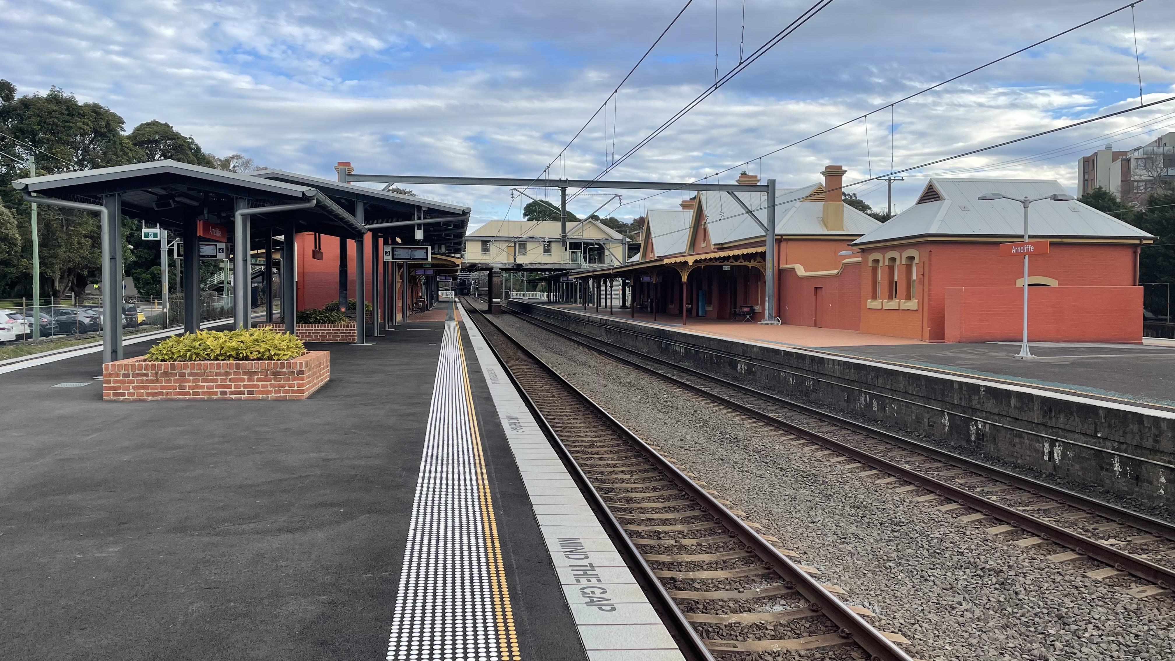
Arncliffe railway station is a heritage-listed railway station located on the Illawarra line, serving the Sydney suburb of Arncliffe in Bayside Council. It is served by Sydney Trains T4 line services. It was added to the New South Wales State Heritage Register on 2 April 1999. History Arncliffe station opened on 15 October 1884 on the same date as the Illawarra line from Redfern to Hurstville with two side platforms. Arncliffe Station was designed as the first major station on the Illawarra Line southwards from Sydney and was one of the most substantial stations of the eight built in 1884, reflecting the importance of the locality. The station, originally known as the Illawarra Road Station, was built by Alfred McNeill and William Clark and designed by the office of the New South Wales Government Railways. Like Sydenham railway station completed in the same year, Arncliffe was constructed with two wayside platforms: the eastern platform contained a 3rd class brick stat ... [...More Info...] [...Related Items...] OR: [Wikipedia] [Google] [Baidu] |
Punchbowl Bus Company
Punchbowl Bus Company is an Australian bus company operating services in Sydney Region 5, servicing the Hurstville, Roselands, Bankstown, Strathfield and surrounding suburbs. It also operates bus services in Goulburn and Crookwell in the Southern Tablelands as PBC Goulburn and PBC Crookwell. History Before 1960 About Us Punchbowl Bus Company Punchbowl Bus Co (PBC) started off as DeLuxe Bus Service run by PM (Pat) Geoghegan in 1943. *July 1943 Route 188 Punchbowl - Mortdale transferred from Boatwright. *29 April 1946 Route 29 Peakhurst - commenced *May 1946 Route 28 ... [...More Info...] [...Related Items...] OR: [Wikipedia] [Google] [Baidu] |
Transdev NSW
Transdev NSW is a bus operator in the northern, southern and western suburbs of Sydney, Australia, operating on behalf of Transport for NSW. It is a subsidiary of Transdev Australasia. It is a different subsidiary to Transdev John Holland, which is 75% owned by Transdev and operates in the eastern suburbs of Sydney. With origins tracing back to February 1935, Transdev NSW was renamed from Veolia Transport NSW in July 2013 after the global rebranding of its parent company Veolia Transdev to simply Transdev. During this time, Transdev Shorelink, another Transdev bus operation in Sydney, was absorbed into Transdev NSW. Between November and December 2022, after a competitive tendering process, Transdev NSW was unsuccessful in retaining all of its existing bus operations. Its operations will be taken by bus companies and Transdev NSW will cease to be a public bus operator in August 2023. However, it will still continue to operate charter bus operations. History The origins of t ... [...More Info...] [...Related Items...] OR: [Wikipedia] [Google] [Baidu] |
Transit Systems NSW
Transit Systems NSW, previously known as Transit Systems Sydney, is a bus operator in Sydney, New South Wales, Australia. It is a subsidiary of Transit Systems. History In November 2012, Transit Systems was awarded a contract by Transport for NSW to operate region 3 bus services in Western Sydney, taking over services operated by Busabout, Hopkinsons, Metro-link and Westbus. Transit Systems also took over route T80 on the Liverpool-Parramatta T-way from Western Sydney Buses. Operations commenced on 13 October 2013. On 1 July 2018, Transit Systems took over the operation of region 6 from State Transit on an eight-year contract operating services in the Canterbury-Bankstown, Eastern Suburbs, Inner West, North Shore and St George regions. In December 2022, after a tendering process, Transit Systems successfully retained region 3 and was additionally awarded the services in region 13, which will be consolidated into region 3. The new contract for the combined region ... [...More Info...] [...Related Items...] OR: [Wikipedia] [Google] [Baidu] |
Bexley Shopping Centre
Bexley is an area of south-eastern Greater London, England and part of the London Borough of Bexley. It is sometimes known as Bexley Village or Old Bexley to differentiate the area from the wider borough. It is located east-southeast of Charing Cross and south of Bexleyheath. Bexley was an ancient parish in the county of Kent. As part of the suburban growth of London in the 20th century, Bexley increased in population, becoming a municipal borough in 1935 and has formed part of Greater London since 1965. History Bexley was an ancient parish in Kent, in the diocese of Rochester, and under the Local Government Act 1894 formed part of Bexley Urban District. The urban district gained further status in 1935 as a municipal borough. Kent County Council formed the second tier of local government during that time. In 1965, London County Council was abolished and replaced by Greater London Council, with an expanded administrative area that took in the metropolitan parts of the Home ... [...More Info...] [...Related Items...] OR: [Wikipedia] [Google] [Baidu] |
Municipality Of Bexley
The Municipality of Bexley was a local government area in the St George region of Sydney, New South Wales, Australia. The municipality was proclaimed as the Borough of Bexley on 28 June 1900 when it formally separated from the Municipal District of Hurstville, and included the modern suburbs of Bexley, Bexley North and Kingsgrove, with parts of Carlton, Bardwell Park, Bardwell Valley, Rockdale and Kogarah. From 1 January 1949, the council was amalgamated into the Municipality of Rockdale, with the passing of the ''Local Government (Areas) Act 1948''. Council history and location The Bexley area was first incorporated on 25 March 1887, when the NSW Government Gazette published the proclamation declaring the "Municipal District of Hurstville", with its wards being created on 29 December 1887, including the "Bexley Ward". Although originally very much of a rural character, by the turn of the 20th century the population of the Bexley Ward area had reached 2850 and a group of l ... [...More Info...] [...Related Items...] OR: [Wikipedia] [Google] [Baidu] |
Trams In Sydney
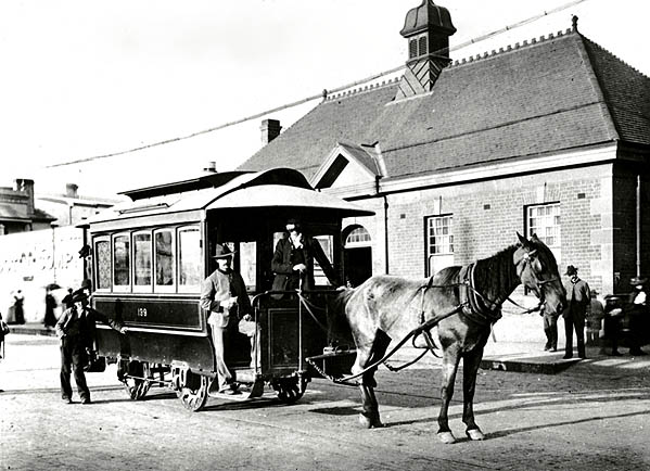
The Sydney tramway network served the inner suburbs of Sydney, Australia from 1879 until 1961. In its heyday, it was the largest in Australia, the second largest in the Commonwealth of Nations (after London), and one of the largest in the world. The network was heavily worked, with about 1,600 cars in service at any one time at its peak during the 1930s (cf. about 500 trams in Melbourne today). Patronage peaked in 1945 at 405 million passenger journeys. Its maximum street trackage totalled 291 km (181 miles) in 1923. History Early tramways Sydney's first tram was horse-drawn, running from the old Sydney railway station to Circular Quay along Pitt Street.''The 1861 Pitt Street Tramway and the Contemporary Horse Drawn Railway Proposals'' Wylie, R.F. Australian Railway Historical Society Bulletin, February, 1965 pp21-32 Built in 1861, the design was compromised by the desire to haul railway freight wagons along the line to supply city businesses and return cargo from ... [...More Info...] [...Related Items...] OR: [Wikipedia] [Google] [Baidu] |
England
England is a country that is part of the United Kingdom. It shares land borders with Wales to its west and Scotland to its north. The Irish Sea lies northwest and the Celtic Sea to the southwest. It is separated from continental Europe by the North Sea to the east and the English Channel to the south. The country covers five-eighths of the island of Great Britain, which lies in the North Atlantic, and includes over 100 smaller islands, such as the Isles of Scilly and the Isle of Wight. The area now called England was first inhabited by modern humans during the Upper Paleolithic period, but takes its name from the Angles, a Germanic tribe deriving its name from the Anglia peninsula, who settled during the 5th and 6th centuries. England became a unified state in the 10th century and has had a significant cultural and legal impact on the wider world since the Age of Discovery, which began during the 15th century. The English language, the Anglican Church, and Eng ... [...More Info...] [...Related Items...] OR: [Wikipedia] [Google] [Baidu] |


