|
Bedford, Nova Scotia
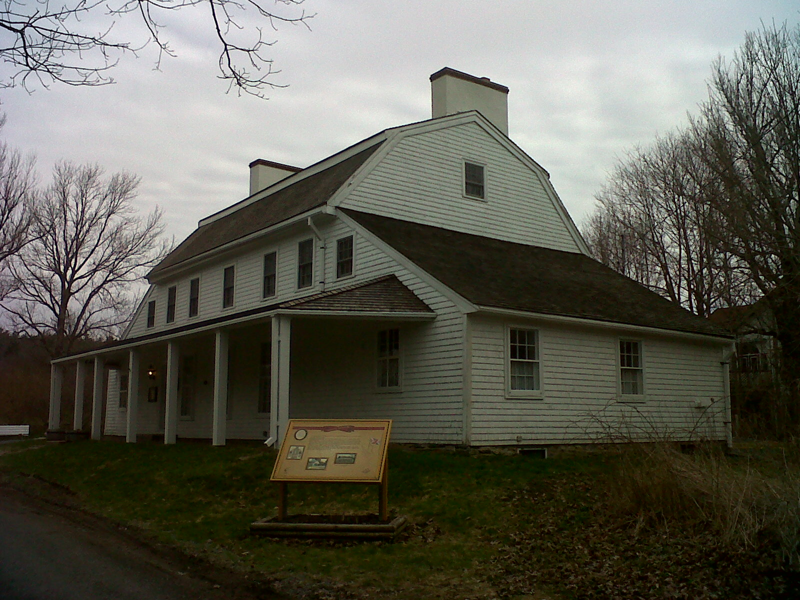
Bedford (pop. 36,354 ) is a former town and now a district of Halifax Regional Municipality, Halifax, Nova Scotia, Canada. It is situated on the north west shore of the Bedford Basin in the central area of the municipality. It borders the neighbouring communities of Hammonds Plains, Nova Scotia, Hammonds Plains to the west, Lower Sackville, Nova Scotia, Sackville to the north, Dartmouth, Nova Scotia, Dartmouth to the east, and Halifax, Nova Scotia, mainland Halifax to the south. Bedford was named in honour of John Russell, 4th Duke of Bedford, Secretary of State for the colonies in 1749. History The area of Bedford has evidence of Indigenous peoples dating back thousands of years. Petroglyphs are found at Bedford Petroglyphs National Historic Site. The Bedford area is known as Kwipek to the Mi'kmaq First Nation. On 21 July 1749, Father Le Loutre's War began when Edward Cornwallis arrived to establish Halifax Regional Municipality, Halifax with 13 transports. The British qui ... [...More Info...] [...Related Items...] OR: [Wikipedia] [Google] [Baidu] [Amazon] |
Amalgamation Of The Halifax Regional Municipality
The amalgamation of four municipalities on April 1, 1996, was the creation of the Halifax Regional Municipality, Nova Scotia, Canada. It resulted in the regional municipality's current boundaries. First amalgamation The current boundaries of Halifax County were established in 1908. Owing to the need for a more efficient county-wide government, the Municipality of the County of Halifax was incorporated in 1962, including all areas in the county outside of the cities of Halifax and Dartmouth. The City of Halifax gradually grew to occupy the entire Halifax Peninsula by the end of World War II. The late 1960s was a period of significant change and expansion of the city when surrounding areas of Halifax County were amalgamated into Halifax: Rockingham, Clayton Park, Fairview, Armdale, and Spryfield were all added in 1969. The biggest change to Dartmouth came in 1955 when the Angus L. MacDonald Bridge opened, connecting Dartmouth to Halifax. Unprecedented suburban growth led In ... [...More Info...] [...Related Items...] OR: [Wikipedia] [Google] [Baidu] [Amazon] |
Bedford Basin
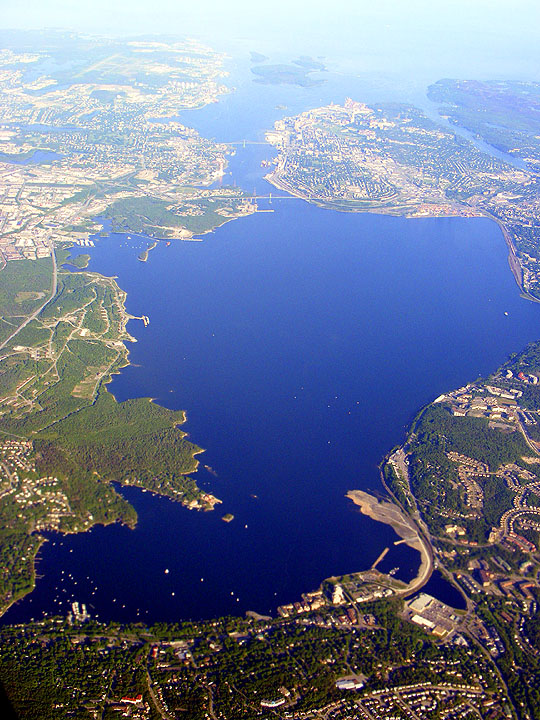
Bedford Basin is a large enclosed bay, forming the northwestern end of Halifax Harbour on Canada's Atlantic coast. It is named in honour of John Russell, 4th Duke of Bedford. Geography Geographically, the basin is situated entirely within the Halifax Regional Municipality (HRM) and is oriented northwest-southeast, measuring approximately long and wide, surrounded by low hills measuring up to in elevation, although most elevations range up to . The basin is fed by water from the Sackville River and has a maximum depth of ; The basin's geologic history can be traced to the Wisconsin Glaciation when it, along with "The Narrows", formed part of the pre-historic Sackville River valley. The basin contains the following sub-basins: * Bedford Bay, in the extreme northwest. * Birch Cove, on the western shore. * Fairview Cove, in the extreme southwest. * Wrights Cove, on the eastern shore. Bedford on the northwestern corner takes its name from the basin, while Dartmouth sits on ... [...More Info...] [...Related Items...] OR: [Wikipedia] [Google] [Baidu] [Amazon] |
Halifax (former City), Nova Scotia
Halifax is the capital and most populous municipality of the Canadian province of Nova Scotia, and the most populous municipality in Atlantic Canada. As of 2024, it is estimated that the population of the Halifax CMA was 530,167, with 348,634 people in its urban area. The regional municipality consists of four former municipalities that were amalgamated in 1996: Halifax, Dartmouth, Bedford, and Halifax County. Halifax is an economic centre of Atlantic Canada, home to a concentration of government offices and private companies. Major employers include the Department of National Defence, Dalhousie University, Nova Scotia Health Authority, Saint Mary's University, the Halifax Shipyard, various levels of government, and the Port of Halifax. Resource industries found in rural areas of the municipality include agriculture, fishing, mining, forestry, and natural gas extraction. History The Mi'kmaq name for Halifax is , pronounced "che-book-took". The name means "Great Ha ... [...More Info...] [...Related Items...] OR: [Wikipedia] [Google] [Baidu] [Amazon] |
Bay Of Fundy
The Bay of Fundy () is a bay between the Canadian provinces of New Brunswick and Nova Scotia, with a small portion touching the U.S. state of Maine. It is an arm of the Gulf of Maine. Its tidal range is the highest in the world. The bay was named ''Bakudabakek'' by the indigenous Mi'kmaq and Passamaquoddy groups, meaning "open way". The Wolastoqiyik peoples named it ''Wekwabegituk'', meaning "waves at the head of the bay". The name "Fundy" has been speculated to have derived from the French word ("split") or ("head of the bay"). Some individuals have disputed this, including William Francis Ganong, who suggested that the name likely derived from Portuguese origin instead, specifically regarding João Álvares Fagundes, who may have referred to the bay as ("Great Bay") and nearby waters as ("deep river"). Hydrology Tides The tidal range in the Bay of Fundy is about ; the average tidal range worldwide is only . Some tides are higher than others, depending on the ... [...More Info...] [...Related Items...] OR: [Wikipedia] [Google] [Baidu] [Amazon] |
Minas Basin
The Minas Basin () is an inlet of the Bay of Fundy and a sub-basin of the Fundy Basin located in Nova Scotia, Canada. It is known for its extremely high tides. Geography The Minas Basin forms the eastern part of the Bay of Fundy which splits at Cape Chignecto and is delineated by the massive basalt headlands of Cape Split and Cape d'Or. The Minas Basin is divided into four sections: (1) the Minas Channel, from the shortest line between Cape Chignecto and the Annapolis Valley Shore to Minas Passage, between Parrsboro and Cape Blomidon; (2) Central Minas Basin, from Minas Passage to the mouth of Cobequid Bay, the shortest line point between Economy and the Noel Shore; (3) Cobequid Bay which extends to the mouth of the Salmon River; and (4) the Southern Bight, from the mouth of the Avon River to the shortest line between Cape Blomidon and the Noel Shore. Several large rivers drain into the Minas Basin: the Shubenacadie River, Cornwallis River, Avon River, Gaspereau Riv ... [...More Info...] [...Related Items...] OR: [Wikipedia] [Google] [Baidu] [Amazon] |
Lawrencetown, Halifax County, Nova Scotia
Lawrencetown (1986 population: 2,680) is a Canadian rural community in the Halifax Regional Municipality in Nova Scotia, Canada. The settlement was established during the eve of Father Le Loutre's War and at the beginning of the French and Indian War. History Father Le Loutre's War began when Edward Cornwallis arrived to establish Halifax with 13 transports on June 21, 1749. To guard against Mi'kmaq, Acadian and French attacks on the new Protestant settlements, British fortifications were erected in Halifax (1749), Bedford ( Fort Sackville) (1749), Dartmouth (1750), Lunenburg (1753) and Lawrencetown (1754). In 1754, Nova Scotia's Lieutenant Governor Charles Lawrence, offered land grants to twenty families, who referred to their settlement as Lawrence's Town, which became Lawrencetown. The Acadians and natives resisted the British occupation of Nova Scotia and Acadia by raiding the various communities. In late April 1754, at the outbreak of the French and Indian War, Jos ... [...More Info...] [...Related Items...] OR: [Wikipedia] [Google] [Baidu] [Amazon] |
Lunenburg, Nova Scotia
Lunenburg () is a port town on the South Shore (Nova Scotia), South Shore of Nova Scotia, Canada. Founded in 1753, the town was one of the first British attempts to settle Protestants in Nova Scotia. Historically, Lunenburg's economy relied on the offshore fishery, and today it hosts Canada's largest secondary fish-processing plant. The town experienced prosperity in the late 1800s, and many of its architectural gems date back to that era. In 1995, United Nations Educational, Scientific and Cultural Organization, UNESCO designated it a World Heritage Site. UNESCO considers the site the best example of planned British colonization of the Americas, British colonial settlement in North America, as it retains its original layout and appearance of the 1800s, including local wooden vernacular architecture. UNESCO considers the town in need of protection because the future of its traditional economic underpinnings, the Atlantic fishery, is now very uncertain. The historic core of th ... [...More Info...] [...Related Items...] OR: [Wikipedia] [Google] [Baidu] [Amazon] |
Fort Sackville (Nova Scotia)
Fort Sackville was a British fort in present-day Bedford, Nova Scotia. It was built during Father Le Loutre's War by British adjacent to present-day Scott Manor House, on a hill overlooking the Sackville River to help prevent French, Acadian and Mi'kmaq attacks on Halifax. The fort consisted of a blockhouse, a guard house, a barracks that housed 50 soldiers, and outbuildings, all encompassed by a palisade. Not far from the fort was a rifle range. The fort was named after George Germain, 1st Viscount Sackville. Historical context Despite the British Siege of Port Royal (1710), Conquest of Acadia in 1710, Nova Scotia remained primarily occupied by Catholic Acadians and Mi'kmaq. Father Le Loutre's War began when Edward Cornwallis arrived to establish City of Halifax, Halifax with 13 transports on June 21, 1749. The British remained largely in Halifax, having attempted to establish a settlement east of Halifax near present-day Lawrencetown Beach they quickly abandoned the effort ... [...More Info...] [...Related Items...] OR: [Wikipedia] [Google] [Baidu] [Amazon] |
Edward Cornwallis
Edward Cornwallis ( – 14 January 1776) was a British career military officer and member of the aristocratic Cornwallis family, who reached the rank of Lieutenant General. After Cornwallis fought in Scotland, putting down the Jacobite rebellion of 1745, he was appointed Groom of the Chamber for King George II (a position he held for the next 17 years). He was then made Governor of Nova Scotia (1749–1752), one of the colonies in North America, and assigned to establish the new town of Halifax, Nova Scotia. Later Cornwallis returned to London, where he was elected as MP for Westminster and married the niece of Robert Walpole, Great Britain's first Prime Minister. Cornwallis was next appointed as Governor of Gibraltar. Cornwallis arrived in Nova Scotia during a period of conflict with the local indigenous Miꞌkmaq peoples of peninsular Nova Scotia. The Mi'kmaq opposed the founding of Halifax and conducted war raids on the colony. Cornwallis responded with the extirpati ... [...More Info...] [...Related Items...] OR: [Wikipedia] [Google] [Baidu] [Amazon] |
Father Le Loutre's War
Father Le Loutre's War (1749–1755), also known as the Indian War, the Mi'kmaq War and the Anglo-Mi'kmaq War, took place between King George's War and the French and Indian War in Acadia and Nova Scotia. On one side of the conflict, the Kingdom of Great Britain, British and New England Colonies, New England colonists were led by British officer Charles Lawrence (British Army officer), Charles Lawrence and New England United States Army Ranger#Colonial Period, Ranger John Gorham (military officer), John Gorham. On the other side, Father Jean-Louis Le Loutre led the Mi'kmaq and the Military history of the Acadians, Acadia militia in guerrilla warfare against settlers and British forces. At the outbreak of the war there were an estimated 2500 Mi'kmaq and 12,000 Acadians in the region. While the British Siege of Port Royal (1710), captured Port Royal in 1710 and were ceded peninsular Acadia in 1713, the Mi'kmaq and Acadians continued to contain the British in settlements at Port-Ro ... [...More Info...] [...Related Items...] OR: [Wikipedia] [Google] [Baidu] [Amazon] |
Mi'kmaq
The Mi'kmaq (also ''Mi'gmaq'', ''Lnu'', ''Mi'kmaw'' or ''Mi'gmaw''; ; , and formerly Micmac) are an Indigenous group of people of the Northeastern Woodlands, native to the areas of Canada's Atlantic Provinces, primarily Nova Scotia, New Brunswick, Prince Edward Island, and Newfoundland, and the Gaspé Peninsula of Quebec as well as Native Americans in the northeastern region of Maine. The traditional national territory of the Mi'kmaq is named Mi'kma'ki (or Mi'gma'gi). There are 66,748 Mi'kmaq people in the region as of 2023 (including 25,182 members in the more recently formed Qalipu First Nation in Newfoundland). According to the Canadian 2021 census, 9,245 people claim to speak Mi'kmaq, an Eastern Algonquian language. Once written in Mi'kmaw hieroglyphic writing, it is now written using most letters of the Latin alphabet. The Mi'kmaq, Maliseet, and Pasamaquoddy nations signed a series of treaties known as the Covenant Chain of Peace and Friendship Treaties with ... [...More Info...] [...Related Items...] OR: [Wikipedia] [Google] [Baidu] [Amazon] |


