|
Ballinderry, Kilcronaghan Civil Parish
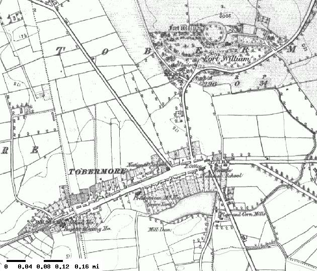
Ballinderry (, ) is a townland lying within the civil parish of Kilcronaghan, County Londonderry, Northern Ireland. It lies on the eastern boundary of the parish; partly bounded by the parishes of Termoneeny and Desertmartin to the north and east. It is also bounded by the townlands of Ballynahone More, Drumsamney, Dromore, Grange, and Gortamney. It was apportioned to the Vintners company. The townland was part of Tobermore electoral ward of the former Magherafelt District Council, however in 1926 it was part of Tobermore district electoral division as part of the Maghera division of Magherafelt Rural District. It was also part of the historic barony of Loughinsholin. History See also *Kilcronaghan *List of townlands in Tobermore *Tobermore Tobermore (, named after the townland of Tobermore) is a small village in County Londonderry, Northern Ireland. It lies south-south-west of Maghera and north-west of Magherafelt. Tobermore lies within the civil parish ... [...More Info...] [...Related Items...] OR: [Wikipedia] [Google] [Baidu] |
Townland
A townland ( ga, baile fearainn; Ulster-Scots: ''toonlann'') is a small geographical division of land, historically and currently used in Ireland and in the Western Isles in Scotland, typically covering . The townland system is of Gaelic origin, pre-dating the Norman invasion, and most have names of Irish origin. However, some townland names and boundaries come from Norman manors, plantation divisions, or later creations of the Ordnance Survey.Connolly, S. J., ''The Oxford Companion to Irish History, page 577. Oxford University Press, 2002. ''Maxwell, Ian, ''How to Trace Your Irish Ancestors'', page 16. howtobooks, 2009. The total number of inhabited townlands in Ireland was 60,679 in 1911. The total number recognised by the Irish Place Names database as of 2014 was 61,098, including uninhabited townlands, mainly small islands. Background In Ireland a townland is generally the smallest administrative division of land, though a few large townlands are further divided into ... [...More Info...] [...Related Items...] OR: [Wikipedia] [Google] [Baidu] |
Ballynahone More, Termoneeny Civil Parish
Ballynahone (Toner, Gregory: ''Place-Names of Northern Ireland, Volume Five, County Derry I, The Moyola Valley'', page 173. The Institute of Irish Studies, The Queen's University Belfast, 1996. ) may refer to the following places in Northern Ireland: *Ballynahone Beg, Maghera civil parish *Ballynahone Bog *Ballynahone More Ballynahone (Toner, Gregory: ''Place-Names of Northern Ireland, Volume Five, County Derry I, The Moyola Valley'', page 173. The Institute of Irish Studies, The Queen's University Belfast, 1996. ) may refer to the following places in Northern Ireland ... References {{geodis ... [...More Info...] [...Related Items...] OR: [Wikipedia] [Google] [Baidu] |
Tobermore
Tobermore (, named after the townland of Tobermore) is a small village in County Londonderry, Northern Ireland. It lies south-south-west of Maghera and north-west of Magherafelt. Tobermore lies within the civil parish of Kilcronaghan and is part of Mid-Ulster District. It was also part of the former barony of Loughinsholin. Tobermore has won the ''Best Kept Small Village'' award four times and the ''Best Kept Large Village'' award in 1986. Most recently in September 2011, Tobermore won the ''Translink Ulster in Bloom'' village category for the third year in a row. Etymology Tobermore is named after the townland of Tobermore which is an anglicisation of the Irish words ''tobar'' meaning "well" and ''mór'' meaning "big/great", thus Tobermore means "big/great well". During the seventeenth century, Tobermore was also known as Tobarmore and Tubbermore, with Tubbermore being the preferred usage of the Masonic Order even to this day. Topography Tobermore lies on the descend ... [...More Info...] [...Related Items...] OR: [Wikipedia] [Google] [Baidu] |
List Of Townlands In Tobermore
There are 37 townlands in Tobermore electoral ward, with 22 of these also constituting the parish of Kilcronaghan. All townlands below are listed with the earliest recorded date of their modern variation as well as the Irish origin if applicable, along with a select list of earlier variations with date. Kilcronaghan ecclesiastical and civil parish There are 23 townlands in the ecclesiastical parish of Kilcronaghan. The civil parish however only contains 21, with Tullyroan and Drumballyhagan Clark being omitted. The townland of Keenaght is the only one that doesn't also form part of Tobermore electoral ward. Tobermore electoral ward There are 37 townlands within Tobermore electoral ward, the majority of which (twenty-two) reside in Kilcronaghan parish. The rest form parts of neighbouring parishes. These additional townlands are: See also *Kilcronaghan *List of townlands in County Londonderry *Tobermore References {{DEFAULTSORT:List Of Townlands In Tobermore Townlands o ... [...More Info...] [...Related Items...] OR: [Wikipedia] [Google] [Baidu] |
Barony (geographic)
A barony is an administrative division of a county in Scotland, Ireland, outlying parts of England and historically France. It has a lower rank and importance than a county. Origin A geographic barony is a remnant from mediaeval times of the area of land held under the form of feudal land tenure termed feudal barony, or barony by tenure, either an English feudal barony, a Scottish feudal barony or an Irish feudal barony, which all operated under different legal and social systems. Just as modern counties are no longer under the administrative control of a noble count or earl, geographic baronies are generally no longer connected with feudal barons, certainly not in England where such tenure was abolished with the whole feudal system by the Tenures Abolition Act 1660. The position in Scotland is more complex, although the legal force of the Scottish feudal baron was abolished early in the 21st century.P. G. B. McNeill and H. L. MacQueen, eds, ''Atlas of Scottish History to 17 ... [...More Info...] [...Related Items...] OR: [Wikipedia] [Google] [Baidu] |
Magherafelt
Magherafelt (, �mˠaxəɾʲəˈfʲiːlt̪ˠə is a small town and civil parish in County Londonderry, Northern Ireland. It had a population of 8,805 at the 2011 Census. It is the biggest town in the south of the county and is the social, economic and political hub of the area. It is part of Mid-Ulster District. History Magherafelt has been documented as a town since 1425. An earlier name for the area was ''Teach Fíolta'' - ‘Fíolta’s (monastic) house’. This would suggest that there was a monastic settlement here under the leadership of Fíolta. The site of the medieval parish church may be marked by the ruins of a later church and graveyard at the bottom of Broad Street. The Salters Company of London was granted the surrounding lands in South Londonderry in the seventeenth century as part of the Plantation of Ulster. Subsequently, the town began to take on its current shape with a central diamond forming the heart of the town. During The Troubles in the late 20th c ... [...More Info...] [...Related Items...] OR: [Wikipedia] [Google] [Baidu] |
Maghera
Maghera (pronounced , ) is a small town at the foot of the Glenshane Pass in County Londonderry, Northern Ireland. Its population was 4,220 in the 2011 Census, increasing from 3,711 in the 2001 Census. It is situated within Mid-Ulster District, as well as the civil parish of Maghera, which it was named after, and the former barony of Loughinsholin. History The town dates back at least to the 6th century to the monastery founded by Saint Lurach whose family were possibly evangelised by Saint Patrick. The ''Annals of Ulster'' say that the seat of the Cenél nEoghain was at Ráth Luraig in Maghera. Standing upon the site of the monastery, the present day ruins of St. Lurach's Church date back to the 10th century. They include, over a doorway, a relief of the crucifixion, possibly the oldest in Ireland. The crucification lintel is reproduced in the contemporary Catholic church, St Mary's. The old church and town were burned in the 12th century. Afterwards, Maghera became the ... [...More Info...] [...Related Items...] OR: [Wikipedia] [Google] [Baidu] |
Magherafelt District Council
Magherafelt District Council was a district council in County Londonderry in Northern Ireland. It was merged with Cookstown District Council and Dungannon and South Tyrone Borough Council on 1 April 2015 under local government reorganisation in Northern Ireland becoming Mid-Ulster District Council. The council headquarters were in Magherafelt. The Council area stretched from Lough Neagh and the River Bann in the east into the Sperrin Mountains in the west and was divided by the Moyola River. It covered an area of and had a population of over 45,000. Local towns in the area included Bellaghy, birthplace of poet Seamus Heaney in 1939. The council was composed of 16 elected representatives. Local elections were held every four years on a proportional representation system. At its last election, in May 2011, those elected were from the following political parties: 9 Sinn Féin, 3 Democratic Unionist Party (DUP), 2 Social Democratic and Labour Party (SDLP) and 2 Ulster Unionist Part ... [...More Info...] [...Related Items...] OR: [Wikipedia] [Google] [Baidu] |
Gortamney
Gortamney (, ) is a townland lying within the civil parish of Kilcronaghan, County Londonderry, Northern Ireland. It lies in the east of the parish alongside the boundary of the civil parish of Termoneeny, and is bounded by the townlands of Ballinderry, Ballynahone More, Clooney, Drumsamney, Killynumber, Killytoney, and Moyesset. It was apportioned to the Drapers company and Crown freeholds. The townland was part of Tobermore electoral ward of the former Magherafelt District Council, however in 1926 it was part of Tobermore district electoral division as part of the Maghera division of Magherafelt Rural District. It was also part of the historic barony of Loughinsholin. History See also *Kilcronaghan *List of townlands in Tobermore *Tobermore Tobermore (, named after the townland of Tobermore) is a small village in County Londonderry, Northern Ireland. It lies south-south-west of Maghera and north-west of Magherafelt. Tobermore lies within the civil pa ... [...More Info...] [...Related Items...] OR: [Wikipedia] [Google] [Baidu] |
Drumsamney
Drumsamney (, ) is a townland lying within the civil parish of Kilcronaghan, County Londonderry, Northern Ireland. It lies in the south-east of the parish on the boundary of the civil parish of Desertmartin, and is bounded by the townlands of; Annagh & Moneysterlin, Ballinderry, Killynumber, Dromore, and Gortamney. In the Plantation of Ulster it was given as a glebe to the Drapers Company. The townland was part of Tobermore electoral ward of the former Magherafelt District Council, however in 1926 it was part of Tobermore district electoral division as part of the Maghera division of Magherafelt Rural District. It was also part of the historic barony of Loughinsholin. Etymology Drumsamney derives its name from the Irish ''Droim Samhna'', meaning "ridge of Samhain". This ridge likely refers to Drumsamney Hill, with the second element of the name relating to the pagan festival of Samhain. The townlands of Drumsawna Beg and Drumsawna More in County Fermanagh also derive fr ... [...More Info...] [...Related Items...] OR: [Wikipedia] [Google] [Baidu] |


