|
Australian Geoscience Data Cube
The Australian Geoscience Data Cube (AGDC) is an approach to storing, processing and analyzing large collections of Earth observation data. The technology is designed to meet challenges of national interest by being agile and flexible with vast amounts of layered grid data. The AGDC reduces processing time of traditional image analysis by calibrating, pre-computing known extents, pixel alignment and storing metadata in a cell lattice structure. The temporal-pixel aligned data can often be analysed faster across space and time dimensions than previous scene based techniques. This allows the AGDC to be flexible in tackling future challenges and improve analysis times on ''every-increasing'' data repositories of earth observation. The AGDC has also been used internationally to allow countries to maintain ecologically sustainable programs and reduce the difficulty curve of utilizing Remote Sensing data. Background The AGDC was originally conceived by Geoscience Australia but is now ... [...More Info...] [...Related Items...] OR: [Wikipedia] [Google] [Baidu] |
Remote Sensing
Remote sensing is the acquisition of information about an physical object, object or phenomenon without making physical contact with the object, in contrast to in situ or on-site observation. The term is applied especially to acquiring information about Earth and other planets. Remote sensing is used in numerous fields, including geophysics, geography, land surveying and most Earth science disciplines (e.g. exploration geophysics, hydrology, ecology, meteorology, oceanography, glaciology, geology). It also has military, intelligence, commercial, economic, planning, and humanitarian applications, among others. In current usage, the term ''remote sensing'' generally refers to the use of satellite- or airborne-based sensor technologies to detect and classify objects on Earth. It includes the surface and the atmosphere and oceans, based on wave propagation, propagated signals (e.g. electromagnetic radiation). It may be split into "active" remote sensing (when a signal is emitted b ... [...More Info...] [...Related Items...] OR: [Wikipedia] [Google] [Baidu] |
MODIS
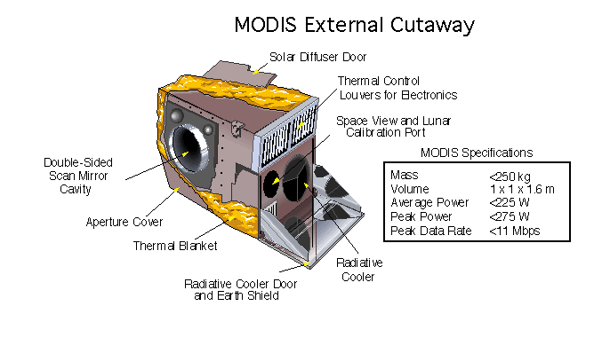
The Moderate Resolution Imaging Spectroradiometer (MODIS) is a satellite-based sensor used for earth and climate measurements. There are two MODIS sensors in Earth orbit: one on board the Terra (EOS AM) satellite, launched by NASA in 1999; and one on board the Aqua (EOS PM) satellite, launched in 2002. Since 2011, MODIS operations have been supplemented by VIIRS sensors, such as the one aboard Suomi NPP. The systems often conduct similar operations due to their similar designs and orbits (with VIIRS data systems deisgned to be compatible with MODIS), though they have subtle differences contributing to similar but not identical uses. The MODIS instruments were built by Santa Barbara Remote Sensing. They capture data in 36 spectral bands ranging in wavelength from 0.4 μm to 14.4 μm and at varying spatial resolutions (2 bands at 250 m, 5 bands at 500 m and 29 bands at 1 km). Together the instruments image the entire Earth every 1 to 2 days. They are designed ... [...More Info...] [...Related Items...] OR: [Wikipedia] [Google] [Baidu] |
Community Planning
Urban planning (also called city planning in some contexts) is the process of developing and designing land use and the built environment, including air, water, and the infrastructure passing into and out of urban areas, such as transportation, communications, and distribution networks, and their accessibility. Traditionally, urban planning followed a top-down approach in master planning the physical layout of human settlements. The primary concern was the public welfare, which included considerations of efficiency, sanitation, protection and use of the environment, as well as taking account of effects of the master plans on the social and economic activities. Over time, urban planning has adopted a focus on the social and environmental " bottom lines" that focuses on using planning as a tool to improve the health and well-being of people and maintain sustainability standards. In the early 21st century, urban planning experts such as Jane Jacobs called on urban planners to ... [...More Info...] [...Related Items...] OR: [Wikipedia] [Google] [Baidu] |
Water Resource Management
Water resources are natural resources of water that are potentially useful for humans, for example as a source of drinking water supply or irrigation water. These resources can be either Fresh water, freshwater from natural sources, or water produced artificially from other sources, such as from reclaimed water (wastewater) or Desalination, desalinated water (seawater). 97% of the water on Earth is saline water, salt water and only three percent is fresh water; slightly over two-thirds of this is frozen in glaciers and polar climate, polar ice caps. The remaining unfrozen freshwater is found mainly as groundwater, with only a small fraction present above ground or in the air. Natural sources of fresh water include surface water, under river flow, groundwater and ice, frozen water. People use water resources for agriculture, agricultural, Industry (economics), industrial and household activities. Water resources are under threat from multiple issues. There is water scarcity, water p ... [...More Info...] [...Related Items...] OR: [Wikipedia] [Google] [Baidu] |
Sustainability
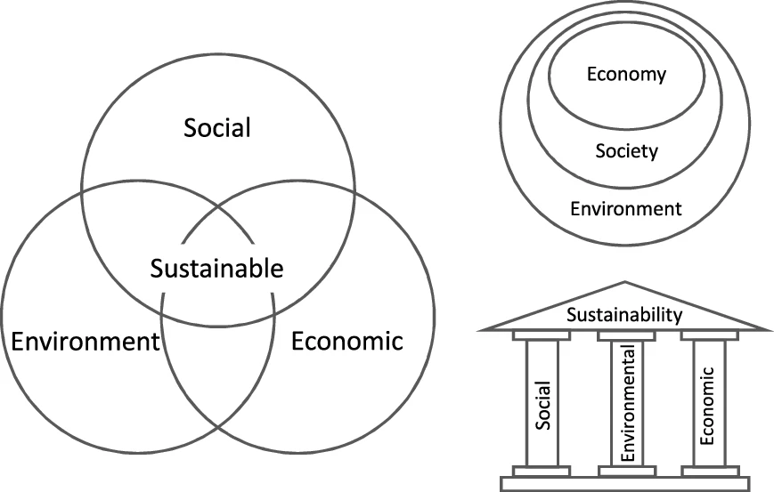
Sustainability is a social goal for people to co-exist on Earth over a long period of time. Definitions of this term are disputed and have varied with literature, context, and time. Sustainability usually has three dimensions (or pillars): environmental, economic, and social. Many definitions emphasize the environmental dimension. This can include addressing key environmental problems, including climate change and biodiversity loss. The idea of sustainability can guide decisions at the global, national, organizational, and individual levels. A related concept is that of sustainable development, and the terms are often used to mean the same thing. UNESCO distinguishes the two like this: "''Sustainability'' is often thought of as a long-term goal (i.e. a more sustainable world), while ''sustainable development'' refers to the many processes and pathways to achieve it." Details around the economic dimension of sustainability are controversial. Scholars have discussed this under ... [...More Info...] [...Related Items...] OR: [Wikipedia] [Google] [Baidu] |
HPCC
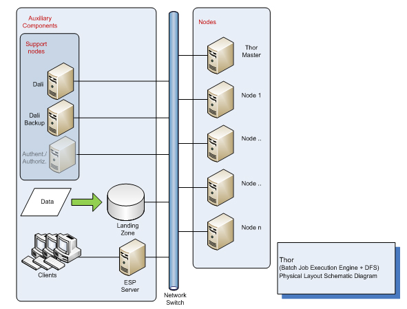
HPCC (High-Performance Computing Cluster), also known as DAS (Data Analytics Supercomputer), is an open source, data-intensive computing system platform developed by LexisNexis Risk Solutions. The HPCC platform incorporates a software architecture implemented on Commodity_computing, commodity computing clusters to provide high-performance, data-parallel processing for applications utilizing big data. The HPCC platform includes system configurations to support both parallel batch data processing (Thor) and high-performance online query applications using indexed data files (Roxie). The HPCC platform also includes a data-centric declarative programming language for parallel data processing called ECL (data-centric programming language), ECL. The public release of HPCC waannouncedin 2011, after ten years of in-house development (according to LexisNexis). It is an alternative to Hadoop and other Big data platforms. System architecture The HPCC system architecture includes tw ... [...More Info...] [...Related Items...] OR: [Wikipedia] [Google] [Baidu] |
GitHub
GitHub () is a Proprietary software, proprietary developer platform that allows developers to create, store, manage, and share their code. It uses Git to provide distributed version control and GitHub itself provides access control, bug tracking system, bug tracking, software feature requests, task management, continuous integration, and wikis for every project. Headquartered in California, GitHub, Inc. has been a subsidiary of Microsoft since 2018. It is commonly used to host open source software development projects. GitHub reported having over 100 million developers and more than 420 million Repository (version control), repositories, including at least 28 million public repositories. It is the world's largest source code host Over five billion developer contributions were made to more than 500 million open source projects in 2024. About Founding The development of the GitHub platform began on October 19, 2005. The site was launched in April 2008 by Tom ... [...More Info...] [...Related Items...] OR: [Wikipedia] [Google] [Baidu] |
Sentinel-2
Sentinel-2 is an Earth observation mission from the Copernicus Programme that acquires optical imagery at high spatial resolution (10 m to 60 m) over land and coastal waters. The mission's Sentinel-2A and Sentinel-2B satellites were joined in orbit in 2024 by a third, Sentinel-2C, and in the future by Sentinel-2D, eventually replacing the A and B satellites, respectively. The mission supports services and applications such as agricultural monitoring, emergencies management, land cover classification, and water quality. Sentinel-2 has been developed and is being operated by the European Space Agency. The satellites were manufactured by a consortium led by Airbus Defence and Space in Friedrichshafen, Germany. Overview The Sentinel-2 mission includes: * Multispectral image, Multi-spectral data with 13 bands in the Visible spectrum, visible, Infrared#Regions within the infrared, near infrared, and Infrared#Regions within the infrared, short wave infrared part of the Electromagnetic ... [...More Info...] [...Related Items...] OR: [Wikipedia] [Google] [Baidu] |
Himawari 8
is a Japanese weather satellite, the 8th of the Himawari geostationary weather satellites operated by the Japan Meteorological Agency. The spacecraft was constructed by Mitsubishi Electric with assistance from Boeing, and is the first of two similar satellites to be based on the DS2000 satellite bus. Himawari 8 entered operational service on 7 July 2015 and is the successor to MTSAT-2 (Himawari 7) which was launched in 2006. Launch Himawari 8 was launched atop a H-IIA rocket flying from the Yoshinobu Launch Complex Pad 1 at the Tanegashima Space Center. The launch occurred at 05:16 UTC on 7 October 2014 and reached its operational geostationary orbit in October 2014, at 35,786 kilometers and 140.7 degrees East. Himawari 9, which is identical to Himawari 8, was launched on 2 November 2016 and placed in a stand-by orbit until 05:00 UTC by 13 December 2022, when it succeeded Himawari 8. Purpose The role of Himawari 8 is to provide typhoon, rainstorm, weather forecast an ... [...More Info...] [...Related Items...] OR: [Wikipedia] [Google] [Baidu] |
Geoscience Australia
Geoscience Australia is a statutory agency of the Government of Australia that carries out geoscientific research. The agency is the government's technical adviser on aspects of geoscience, and serves as the repository of geographic and geological data collated by the Commonwealth. On a user pays basis, the agency offers geospatial services, including topographic maps and satellite imagery. It is also a major contributor to the Australian Government's free, open data collections such as and . Strategic priorities The agency has six strategic priority areas: # building Australia's resource wealth in order to maximise benefits from Australia's minerals and energy resources, now and into the future; # ensuring Australia's community safety so that Australian communities are more resilient to natural hazards; # securing Australia's water resources in order to optimise and sustain the use of Australia's water resources; # managing Australia's marine jurisdictions in order to m ... [...More Info...] [...Related Items...] OR: [Wikipedia] [Google] [Baidu] |
SRTM
The Shuttle Radar Topography Mission (SRTM) is an international research effort that obtained digital elevation models on a near-global scale from 56th parallel south, 56°S to 60th parallel north, 60°N, to generate the most complete high-resolution digital topographic database of Earth prior to the release of the ASTER GDEM in 2009. SRTM consisted of a specially modified radar system that flew on board the Space Shuttle Endeavour during the 11-day STS-99 mission in February 2000. The radar system was based on the older ''Spaceborne Imaging Radar, Spaceborne Imaging Radar-C/X-band Synthetic Aperture Radar'' (SIR-C/X-SAR), previously used on the Shuttle in 1994. To acquire Topography, topographic data, the SRTM payload was outfitted with two radar antennas. One antenna was located in the Shuttle's payload bay, the other – a critical change from the SIR-C/X-SAR, allowing single-pass interferometry – on the end of a 60-meter (200-foot) mast that extended from the payload bay on ... [...More Info...] [...Related Items...] OR: [Wikipedia] [Google] [Baidu] |
USGS
The United States Geological Survey (USGS), founded as the Geological Survey, is an government agency, agency of the United States Department of the Interior, U.S. Department of the Interior whose work spans the disciplines of biology, geography, geology, and hydrology. The agency was founded on March 3, 1879, to study the landscape of the United States, its natural resources, and the natural hazards that threaten it. The agency also makes maps of planets and moons, based on data from List of NASA missions, U.S. space probes. The sole scientific agency of the U.S. Department of the Interior, USGS is a fact-finding research organization with no regulatory responsibility. It is headquartered in Reston, Virginia, with major offices near Lakewood, Colorado; at the Denver Federal Center; and in NASA Research Park in California. In 2009, it employed about 8,670 people. The current motto of the USGS, in use since August 1997, is "science for a changing world". The agency's previous s ... [...More Info...] [...Related Items...] OR: [Wikipedia] [Google] [Baidu] |


