|
Antigo
Antigo ( ) is a city in and the county seat of Langlade County, Wisconsin, United States. The population was 8,100 at the 2020 United States census, 2020 census. Antigo is the center of a farming and lumbering district, and its manufactured products consist principally of lumber, chairs, furniture, sashes, doors and blinds, hubs and spokes, and other wood products. History The name Antigo is derived from the Ojibwe language, Ojibwe phrase "''niibin-inaandagoog-ziibiing''", meaning "summer balsam firs by the river", which was recorded by early settlers as "''nequi-antigo-sebi''". An alternate etymology, ''nibii-aamijiwan-ziibiing'', seems to be derived from ''mookijiwan-ziibiwishenh'', "spring little-river", which became the name of the river which runs through modern Antigo, Spring Brook. This alternate etymology lives on in the name of Northeast Illinois Council#Ma-Ka-Ja-Wan Scout Reservation, Ma-Ka-Ja-Wan Scout Reservation near Pearson, Wisconsin, Pearson. The region that is ... [...More Info...] [...Related Items...] OR: [Wikipedia] [Google] [Baidu] [Amazon] |
Antigo Public Library And Deleglise Cabin
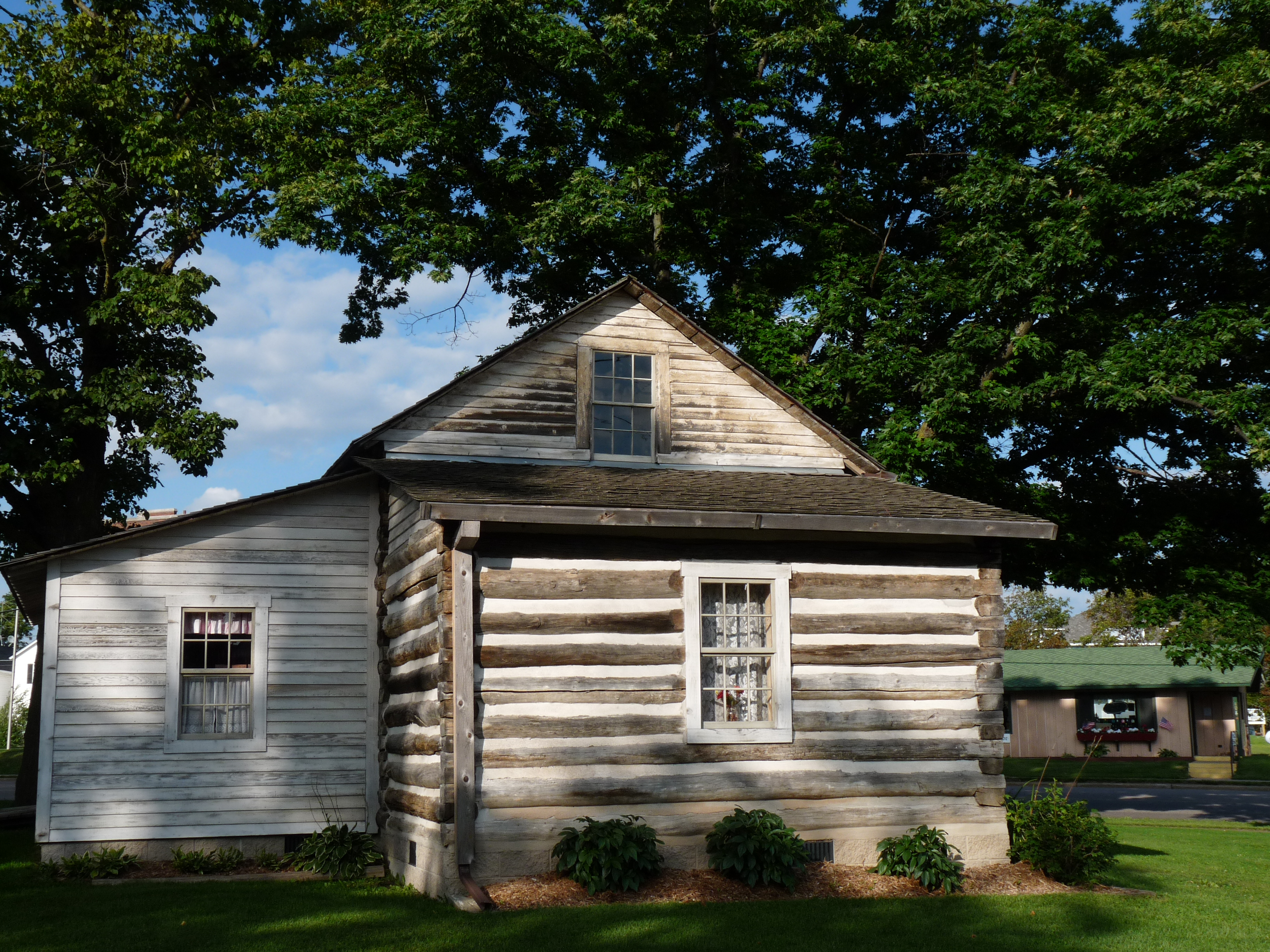
The Antigo Public Library and Deleglise Cabin comprise a historic site in Antigo, Wisconsin. The library building is a Carnegie library built in 1904. In 1997, the Antigo Public Library left the building; it is now a museum and the headquarters of the Langlade County Historical Society. The Deleglise Cabin, the first home in Antigo, was constructed by George Eckart in 1878 on the Springbrook and inhabited by Francis A. Deleglise. The cabin was moved near the library in 1916. Both buildings were added to the National Register of Historic Places on December 18, 1978. The buildings are now part of the Langlade County Historical Society Museum. The Deleglise Cabin was completely restored with the surveyor's office and kitchen lean-tos added on. It is available for viewing on the museum grounds.Stores of YesterYear References External links Langlade County Historical Society Museum {{National Register of Historic Places Houses on the National Register of Historic Places in W ... [...More Info...] [...Related Items...] OR: [Wikipedia] [Google] [Baidu] [Amazon] |
Antigo (soil)
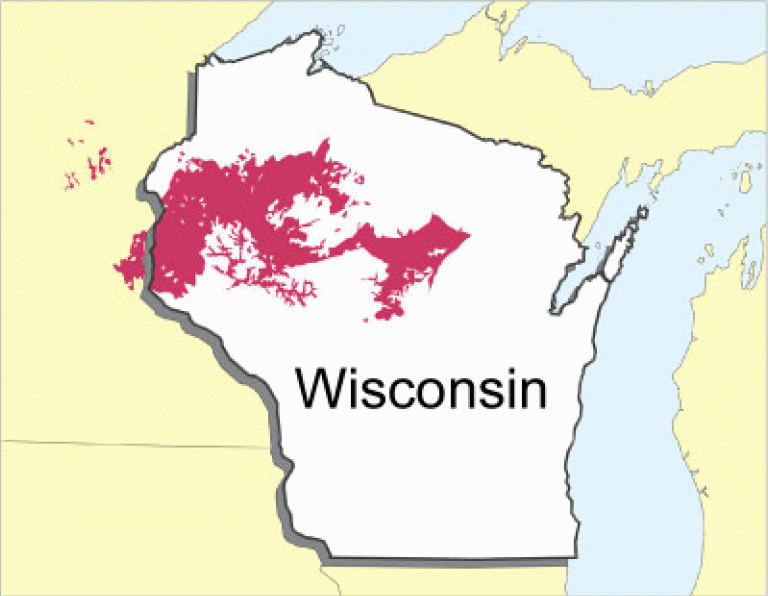
Antigo soils are among the most extensive soils in Wisconsin. They occur on about 300,000 acres (1,200 km²) in the northern part of the state. Antigo soils are well-drained and formed under northern hardwood forests in loess and loamy sediments over stratified sandy outwash. The average annual precipitation ranges from , and the average annual air temperature ranges from . The soil series was named after the city of Antigo, Wisconsin. They are very productive soils for corn, small grain, and hay. In some areas, potatoes or snap beans are important crops. The steeper areas are used for pasture or for timber production. In 1983, with the lobbying of University of Wisconsin–Madison soil scientist Francis Hole, the Wisconsin Legislature designated Antigo silt loam as the official state soil of Wisconsin. References External links * * * *{{cite web , archiveurl= https://web.archive.org/web/20101011045653/http://www2.ftw.nrcs.usda.gov/osd/dat/A/ANTIGO.html , archivedat ... [...More Info...] [...Related Items...] OR: [Wikipedia] [Google] [Baidu] [Amazon] |
Langlade County, Wisconsin
Langlade County is a county (United States), county located in the U.S. state of Wisconsin. As of the 2020 United States census, 2020 census, the population was 19,491. Its county seat is Antigo, Wisconsin, Antigo. History Langlade County was created on March 3, 1879, as New County. It was renamed Langlade County, in honor of Charles de Langlade, on February 20, 1880, and fully organized on February 19, 1881. The county's original borders extended northward from the top of Shawano County, Wisconsin, Shawano County up to the Michigan state line. Between 1881 and 1885, the borders of Langlade County changed as nearby Lincoln and Shawano counties added or gave up area. Langlade lost its northernmost area along the Michigan border to Forest County when it was created in 1885. Geography According to the United States Census Bureau, U.S. Census Bureau, the county has a total area of , of which is land and (1.9%) is water. The highest point in the county is at the foot of the Basswo ... [...More Info...] [...Related Items...] OR: [Wikipedia] [Google] [Baidu] [Amazon] |
Wisconsin
Wisconsin ( ) is a U.S. state, state in the Great Lakes region, Great Lakes region of the Upper Midwest of the United States. It borders Minnesota to the west, Iowa to the southwest, Illinois to the south, Lake Michigan to the east, Michigan to the northeast, and Lake Superior to the north. With a population of about 6 million and an area of about 65,500 square miles, Wisconsin is the List of U.S. states and territories by population, 20th-largest state by population and the List of U.S. states and territories by area, 23rd-largest by area. It has List of counties in Wisconsin, 72 counties. Its List of municipalities in Wisconsin by population, most populous city is Milwaukee; its List of capitals in the United States, capital and second-most populous city is Madison, Wisconsin, Madison. Other urban areas include Green Bay, Wisconsin, Green Bay, Kenosha, Wisconsin, Kenosha, Racine, Wisconsin, Racine, Eau Claire, Wisconsin, Eau Claire, and the Fox Cities. Geography of Wiscon ... [...More Info...] [...Related Items...] OR: [Wikipedia] [Google] [Baidu] [Amazon] |
List Of Counties In Wisconsin
There are 72 County (United States), counties in the U.S. state of Wisconsin. The land that eventually became Wisconsin was transferred from British to American control with the 1783 signing of the Treaty of Paris (1783), Treaty of Paris. It was an unorganized part of the Northwest Territory until 1802 when all of the land from St. Louis north to the Canadian border was organized as St. Clair County, Illinois, St. Clair County. When Illinois was admitted to the union in 1818, Wisconsin became part of the Territory of Michigan and divided into two counties: Brown County, Wisconsin, Brown County in the northeast along Lake Michigan and Crawford County, Wisconsin, Crawford County in the southwest along the Mississippi River. Iowa County, Wisconsin, Iowa County was formed in 1829 from the Crawford County land south of the Wisconsin River. Brown County's southern portion was used to form Milwaukee County, Wisconsin, Milwaukee County in 1834. The state of Wisconsin was created from Wi ... [...More Info...] [...Related Items...] OR: [Wikipedia] [Google] [Baidu] [Amazon] |
Area Codes 715 And 534
Area codes 715 and 534 are telephone area codes in the North American Numbering Plan (NANP) for the U.S. state of Wisconsin. The numbering plan area (NPA) comprises most of the northern part of the state. 715 was one of the original North American area codes created in 1947, while 534 was added in 2010 as an additional code for the same numbering plan area to form an overlay plan. History In October 1947, the American Telephone and Telegraph Company (AT&T) published the first nationwide telephone numbering plan in coordination with independent telephone operators. North America was mapped into eighty-six numbering plan areas (NPAs) and each assigned a unique three-digit area code. Wisconsin was divided into two NPAs. Its northern part received area code 715, while the rest was assigned area code 414. As each NPA could initially only host about 500 central offices with 10,000 lines each, NPAs would be split over time to avoid code exhaustion or improve routing efficiency. In ... [...More Info...] [...Related Items...] OR: [Wikipedia] [Google] [Baidu] [Amazon] |
Wausau, Wisconsin
Wausau ( ) is a city in Marathon County, Wisconsin, United States, and its county seat. It is located along the Wisconsin River and had a population of 39,994 as of the 2020 United States census, 2020 census. It is the core city of the Wausau Metropolitan statistical area, metropolitan area, which includes all of Marathon County and had a population of 138,013 in 2020. The city's suburbs include Schofield, Wisconsin, Schofield, Weston, Wisconsin, Weston, Mosinee, Wisconsin, Mosinee, Maine, Marathon County, Wisconsin, Maine, Rib Mountain (town), Wisconsin, Rib Mountain, Kronenwetter, Wisconsin, Kronenwetter, and Rothschild, Wisconsin, Rothschild. History Establishment and early history This area has for millennia changed hands between various indigenous peoples. The historic Ojibwe (also known in the United States as the Chippewa) occupied it in the period of European encounter. They had a lucrative fur trade for decades with French colonists and French Canadians. After the ... [...More Info...] [...Related Items...] OR: [Wikipedia] [Google] [Baidu] [Amazon] |
Pearson, Wisconsin
Pearson is an unincorporated community in the town of Ainsworth, Langlade County, Wisconsin, United States. Pearson is west of Pickerel and north-northeast of Antigo, the county seat of Langlade County. The community is situated on Pickerel Creek near its confluence with the Wolf River. County Highway T runs through Pearson; the closest state highway to the community is Wisconsin State Highway 55 in Pickerel. Pearson had a post office, which closed on May 4, 1996; ZIP code 54462 still serves the community. The Northeast Illinois Council of the Boy Scouts of America Scouting America is the largest scouting organization and one of the largest List of youth organizations, youth organizations in the United States, with over 1 million youth, including nearly 200,000 female participants. Founded as the Boy Sco ... runs a summer camp, Ma-Ka-Ja-Wan Scout Reservation, in Pearson. The Pickerel Volunteer Fire Department Station is located east of the community on Johnson Ro ... [...More Info...] [...Related Items...] OR: [Wikipedia] [Google] [Baidu] [Amazon] |
City
A city is a human settlement of a substantial size. The term "city" has different meanings around the world and in some places the settlement can be very small. Even where the term is limited to larger settlements, there is no universally agreed definition of the lower boundary for their size. In a narrower sense, a city can be defined as a permanent and Urban density, densely populated place with administratively defined boundaries whose members work primarily on non-agricultural tasks. Cities generally have extensive systems for housing, transportation, sanitation, Public utilities, utilities, land use, Manufacturing, production of goods, and communication. Their density facilitates interaction between people, government organisations, government organizations, and businesses, sometimes benefiting different parties in the process, such as improving the efficiency of goods and service distribution. Historically, city dwellers have been a small proportion of humanity overall, bu ... [...More Info...] [...Related Items...] OR: [Wikipedia] [Google] [Baidu] [Amazon] |
Milwaukee
Milwaukee is the List of cities in Wisconsin, most populous city in the U.S. state of Wisconsin. Located on the western shore of Lake Michigan, it is the List of United States cities by population, 31st-most populous city in the United States and the fifth-most populous city in the Midwest with a population of 577,222 at the 2020 United States census, 2020 census. It is the county seat of Milwaukee County, Wisconsin, Milwaukee County. The Milwaukee metropolitan area is the Metropolitan statistical area, 40th-most populous metropolitan area in the U.S. with 1.57 million residents. Founded in the early 19th century and incorporated in 1846, Milwaukee grew rapidly due to its location as a port city. History of Milwaukee, Its history was heavily influenced by German immigrants and it continues to be a Germans in Milwaukee, center for German-American culture, specifically known for Beer in Milwaukee, its brewing industry. The city developed as an industrial powerhouse during the 19t ... [...More Info...] [...Related Items...] OR: [Wikipedia] [Google] [Baidu] [Amazon] |
Humid Continental Climate
A humid continental climate is a climatic region defined by Russo-German climatologist Wladimir Köppen in 1900, typified by four distinct seasons and large seasonal temperature differences, with warm to hot (and often humid) summers, and cold (sometimes severely cold in the northern areas) and snowy winters. Precipitation is usually distributed throughout the year, but often these regions do have dry seasons. The definition of this climate in terms of temperature is as follows: the mean temperature of the coldest month must be below or depending on the isotherm, and there must be at least four months whose mean temperatures are at or above . In addition, the location in question must not be semi-arid or arid. The cooler ''Dfb'', ''Dwb'', and ''Dsb'' subtypes are also known as hemiboreal climates. Although amount of snowfall is not a factor used in defining the humid continental climate, snow during the winter in this type of climate is almost a guarantee, either intermitte ... [...More Info...] [...Related Items...] OR: [Wikipedia] [Google] [Baidu] [Amazon] |
United States Census Bureau
The United States Census Bureau, officially the Bureau of the Census, is a principal agency of the Federal statistical system, U.S. federal statistical system, responsible for producing data about the American people and American economy, economy. The U.S. Census Bureau is part of the United States Department of Commerce, U.S. Department of Commerce and its Director of the United States Census Bureau, director is appointed by the president of the United States. Currently, Ron S. Jarmin is the acting director of the U.S. Census Bureau. The Census Bureau's primary mission is conducting the United States census, U.S. census every ten years, which allocates the seats of the United States House of Representatives, U.S. House of Representatives to the U.S. state, states based on their population. The bureau's various censuses and surveys help allocate over $675 billion in federal funds every year and it assists states, local communities, and businesses in making informed decisions. T ... [...More Info...] [...Related Items...] OR: [Wikipedia] [Google] [Baidu] [Amazon] |


