|
ŇěanlńĪurfa Province
ŇěanlńĪurfa Province (; ), also known as Urfa Province, is a Provinces of Turkey, province and Metropolitan municipalities in Turkey, metropolitan municipality in southeastern Turkey. The city of ŇěanlńĪurfa is the capital of the province which bears its name. Its area is 19,242 km2, and its population is 2,170,110 (2022). The province is considered part of Turkish Kurdistan and has a Kurds, Kurdish majority with a significant Arabs, Arab and Turkish people, Turkish minority. Districts ŇěanlńĪurfa province is divided into 13 Districts of Turkey, districts, listed below with their populations as at 31 December 2022 according to the official government estimates: * Ak√ßakale (123,721) * Birecik (93,613) * Bozova (52,680) * CeylanpńĪnar (90,440) * Eyy√ľbiye (391,795) * Halfeti (41,662) * Haliliye (396,656) * Harran (96,072) * Hilvan (42,218) * Karak√∂pr√ľ (265,035) * Siverek (267,942) * Suru√ß (100,961) * ViranŇüehir (207,315) Geography With an area of , it is the larg ... [...More Info...] [...Related Items...] OR: [Wikipedia] [Google] [Baidu] [Amazon] |
ŇěanlńĪurfa
Urfa, officially called ŇěanlńĪurfa (), is a city in southeastern Turkey and the capital of ŇěanlńĪurfa Province. The city was known as Edessa from Hellenistic times and into Christian times. Urfa is situated on a plain about east of the Euphrates. Its climate features extremely hot, dry summers and cool, moist winters. About northeast of the city is the famous Neolithic site of G√∂bekli Tepe, the world's oldest known temple, which was founded in the 10th millennium BC. The area was part of a network of the first human settlements where the agricultural revolution took place. Because of its association with Jewish, Christian, and Islamic history, and a legend according to which it was the hometown of Abraham, Urfa is nicknamed the "City of Prophets." Religion is important in Urfa. The city "has become a center of fundamentalist Islamic beliefs" and "is considered one of the most devoutly religious cities in Turkey". The city is located 30 miles from the Atat√ľrk Dam, a ... [...More Info...] [...Related Items...] OR: [Wikipedia] [Google] [Baidu] [Amazon] |
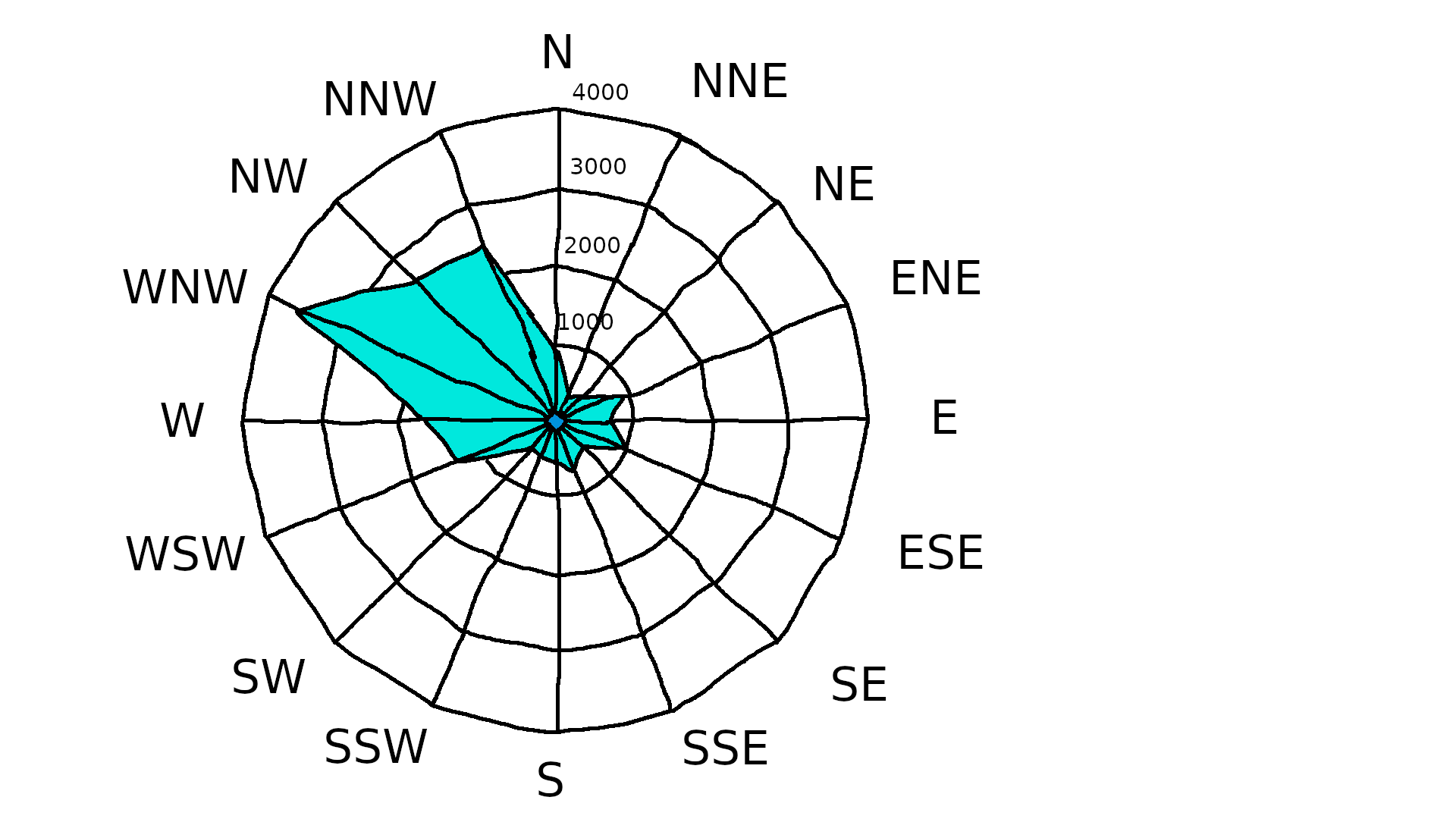
Urfa Wind Rose
Urfa, officially called ŇěanlńĪurfa (), is a city in southeastern Turkey and the capital of ŇěanlńĪurfa Province. The city was known as Edessa from Hellenistic period, Hellenistic times and into Christian times. Urfa is situated on a plain about east of the Euphrates. Its climate features extremely hot, dry summers and cool, moist winters. About northeast of the city is the famous Neolithic site of G√∂bekli Tepe, the world's oldest known temple, which was founded in the 10th millennium BC. The area was part of a network of the first human settlements where the Neolithic Revolution, agricultural revolution took place. Because of its association with Jewish history, Jewish, History of Christianity, Christian, and History of Islam, Islamic history, and a legend according to which it was the hometown of Abraham, Urfa is nicknamed the "City of Prophets." Religion is important in Urfa. The city "has become a center of fundamentalist Islamic beliefs" and "is considered one of the m ... [...More Info...] [...Related Items...] OR: [Wikipedia] [Google] [Baidu] [Amazon] |
Göbekli Tepe
Göbekli Tepe (, ; Kurdish: or , 'Wish Hill') is a Neolithic archaeological site in Upper Mesopotamia (''al-Jazira'') in modern-day Turkey. The settlement was inhabited from around to at least , during the Pre-Pottery Neolithic. It is famous for its large circular structures that contain massive stone pillarsamong the world's oldest known megaliths. Many of these pillars are decorated with anthropomorphic details, clothing, and sculptural reliefs of wild animals, providing archaeologists rare insights into prehistoric religion and the particular iconography of the period. The high, tell is densely covered with ancient domestic structures and other small buildings, quarries, and stone-cut cisterns from the Neolithic, as well as some traces of activity from later periods. The site was first used at the dawn of the southwest Asian Neolithic period, which marked the appearance of the oldest permanent human settlements anywhere in the world. Prehistorians link this Neolith ... [...More Info...] [...Related Items...] OR: [Wikipedia] [Google] [Baidu] [Amazon] |
Mardin Province
Mardin Province (; ; ; ) is a province and metropolitan municipality in Turkey. Its area is 8,780 km2, and its population is 870,374 (2022). The largest city in the province is KńĪzńĪltepe, while the capital Mardin is the second largest city. Districts Mardin Province is divided into 10 districts: * Artuklu * Darge√ßit * Derik * KńĪzńĪltepe * MazńĪdańüńĪ * Midyat * Nusaybin * √Ėmerli * Savur * YeŇüilli Demographics Mardin Province is a linguistically, ethnically and religiously diverse province. The dominant ethnic groups are Arabs, Assyrians, and Kurds, of which Kurds constitute a majority. Other minor groups include Armenians, Chechens and Turks, while Jews lived in the area before migrating to Israel around 1948. The Chechens settled in the region during the Russo-Turkish War in 1877/1878. The distinctive Mhallami community also reside in the district. The province is considered part of Turkish Kurdistan. In 1990, it was estimated that Kurds const ... [...More Info...] [...Related Items...] OR: [Wikipedia] [Google] [Baidu] [Amazon] |
Syria
Syria, officially the Syrian Arab Republic, is a country in West Asia located in the Eastern Mediterranean and the Levant. It borders the Mediterranean Sea to the west, Turkey to Syria‚ÄďTurkey border, the north, Iraq to Iraq‚ÄďSyria border, the east and southeast, Jordan to Jordan‚ÄďSyria border, the south, and Israel and Lebanon to Lebanon‚ÄďSyria border, the southwest. It is a republic under Syrian transitional government, a transitional government and comprises Governorates of Syria, 14 governorates. Damascus is the capital and largest city. With a population of 25 million across an area of , it is the List of countries and dependencies by population, 57th-most populous and List of countries and dependencies by area, 87th-largest country. The name "Syria" historically referred to a Syria (region), wider region. The modern state encompasses the sites of several ancient kingdoms and empires, including the Eblan civilization. Damascus was the seat of the Umayyad Caliphate and ... [...More Info...] [...Related Items...] OR: [Wikipedia] [Google] [Baidu] [Amazon] |
AdńĪyaman Province
AdńĪyaman Province (, ) is a Provinces of Turkey, province in the Southeastern Anatolia Region of Turkey. The capital is AdńĪyaman. Its area is 7,337 km2, and its population is 635,169 (2022). The province is considered part of Turkish Kurdistan and has a Kurds, Kurdish majority. AdńĪyaman Province was part of the province of Malatya until 1954, when it was made into a province as a reward for voting for the winning Democrat Party (Turkey, historical), Democratic Party in the 1954 Turkish general election, 1954 general election. History Early Armenian rule Armenians, Armenian existence in AdńĪyaman dates back to the 4th century, where they were known as 'fire worshippers'. Armenians lived in the area when Islam, Muslim Arabs captured the area in 639. The Arabs considered the city as part of Sasanian Armenia, Armenia and experienced immigration from Byzantine Armenia due to Byzantine oppression in 713. The city came under Seljuk Empire, Seljuk rule after the Battle of Man ... [...More Info...] [...Related Items...] OR: [Wikipedia] [Google] [Baidu] [Amazon] |
ViranŇüehir
ViranŇüehir () is a municipality and district of ŇěanlńĪurfa Province, Turkey. Its area is 2,297 km2, and its population is 207,315 (2022). It is a market town serving a cotton-growing area, 93 km east of the city ŇěanlńĪurfa and 53 km north-west of CeylanpńĪnar at the Syrian border. In Late Antiquity, it was known as Constantina or Constantia () by the Romans and Byzantines, and Tella by the local Assyrian/Syriac population. History According to the Byzantine historian John Malalas, the city was built by the Roman Emperor Constantine I on the site of former Maximianopolis, which had been destroyed by a Persian attack and an earthquake. During the next two centuries, it was an important location in the Roman/Byzantine Near East, playing a crucial role in the Roman‚ÄďPersian Wars of the 6th century as the seat of the '' dux Mesopotamiae'' (363‚Äď540). It was also a bishopric, suffragan of Edessa. Jacob Baradaeus was born near the city and was a monk in ... [...More Info...] [...Related Items...] OR: [Wikipedia] [Google] [Baidu] [Amazon] |
Suruç
Suru√ß (; ; ''SruŠł°'') is a municipality and Districts of Turkey, district of ŇěanlńĪurfa Province, Turkey. Its area is 744 km2, and its population is 100,961 (2022). It is on a plain near the Syria‚ÄďTurkey border, Syrian border southwest of the city of Urfa. Its inhabitants are Kurds. History Suru√ß is situated in a fertile district that is well-suited to growing fruits and grapevines. It is centrally located between the Euphrates on the west and Urfa and Harran on the east; it is about a day's journey from both cities (using pre-industrial transportation). This traffic brought it some degree of commercial prosperity as well. This was also helped by its historical status as a stage station, post station between Raqqa and Sumaysat. The town itself was primarily agricultural, and Ibn Jubayr in the 12th century described seeing orchards and irrigation channels within the area of the town itself. In antiquity the Sumerians built a settlement in the area. The city was a centre ... [...More Info...] [...Related Items...] OR: [Wikipedia] [Google] [Baidu] [Amazon] |
Siverek
Siverek (; ; ) is a municipality and district of ŇěanlńĪurfa Province, Turkey. Its area is 3,936 km2, and its population is 267,942 (2022). Siverek is in the ŇěanlńĪurfa province but is geographically closer to the large city of DiyarbakńĪr (approx. 83 km). A majority of the population of the province is Zaza Kurds. History Siverek was historically known in medieval Arabic as Hisn ar-Ran (), which was corrupted into Greek as Chasanara (), as found in the Escorial Taktikon. The town came under Byzantine control sometime after 956 and had become the seat of a ''strategos'' by the early 970s. Together with Edessa, Gargar, Samosata and Hisn Mansur formed part of the Byzantine defence system up to the 1060s when 200 Frankish horsemen were stationed there. In the Ottoman Empire period, Siverek was within the Diyarbekir vilayet, and it had several Christian settlements. Demographics 9,275 Armenians lived in the kaza on the eve of the First World War according to the ... [...More Info...] [...Related Items...] OR: [Wikipedia] [Google] [Baidu] [Amazon] |
Karak√∂pr√ľ
Karak√∂pr√ľ () is a municipality and district of ŇěanlńĪurfa Province, Turkey. Its area is 1,222 km2, and its population is 265,035 (2022). The district Karak√∂pr√ľ was created at the 2013 reorganisation from part of the former central district of ŇěanlńĪurfa Province, along with the new districts Eyy√ľbiye and Haliliye. It covers the northern part of the agglomeration of ŇěanlńĪurfa and the adjacent countryside. Its eponymous city center is slightly north from central Urfa. In the local elections of March 2019, Metin Baydilli was elected Mayor of Karak√∂pr√ľ. The current Kaymakam is Yakup KńĪlńĪn√ßońülu. Composition There are 100 neighbourhoods A neighbourhood (Commonwealth English) or neighborhood (American English) is a geographically localized community within a larger town, city, suburb or rural area, sometimes consisting of a single street and the buildings lining it. Neighbourh ... in Karak√∂pr√ľ District: [...More Info...] [...Related Items...] OR: [Wikipedia] [Google] [Baidu] [Amazon] |
Hilvan
Hilvan (, ) is a municipality and district of ŇěanlńĪurfa Province, Turkey. Its area is 1,111 km2, and its population is 42,218 (2022). It is 55 km north from the city of ŇěanlńĪurfa. Composition There are 71 neighbourhoods A neighbourhood (Commonwealth English) or neighborhood (American English) is a geographically localized community within a larger town, city, suburb or rural area, sometimes consisting of a single street and the buildings lining it. Neighbourh ... in Hilvan District: Turkey Civil Administration Departments Inventory. Retrieved 19 September 2023. * AńüńĪlmus * Ańüveren * Ak√ßakebir * Ak√ßa√∂ren * AlpńĪ * Arabuk * ArńĪca * ArńĪnńĪk * ArpalńĪ * ArslanlńĪ * AŇüańüńĪ√ßatak * AŇüańüńĪekece * AŇüańüńĪkamńĪŇü * AŇüańüńĪk√ľl√ľn√ße * AydńĪnlńĪ * Bańülar * Bah√ßecik * Bah√ßelievler * BalkńĪ * Barga√ß * B√∂ ... [...More Info...] [...Related Items...] OR: [Wikipedia] [Google] [Baidu] [Amazon] |


