|
Çamyuva
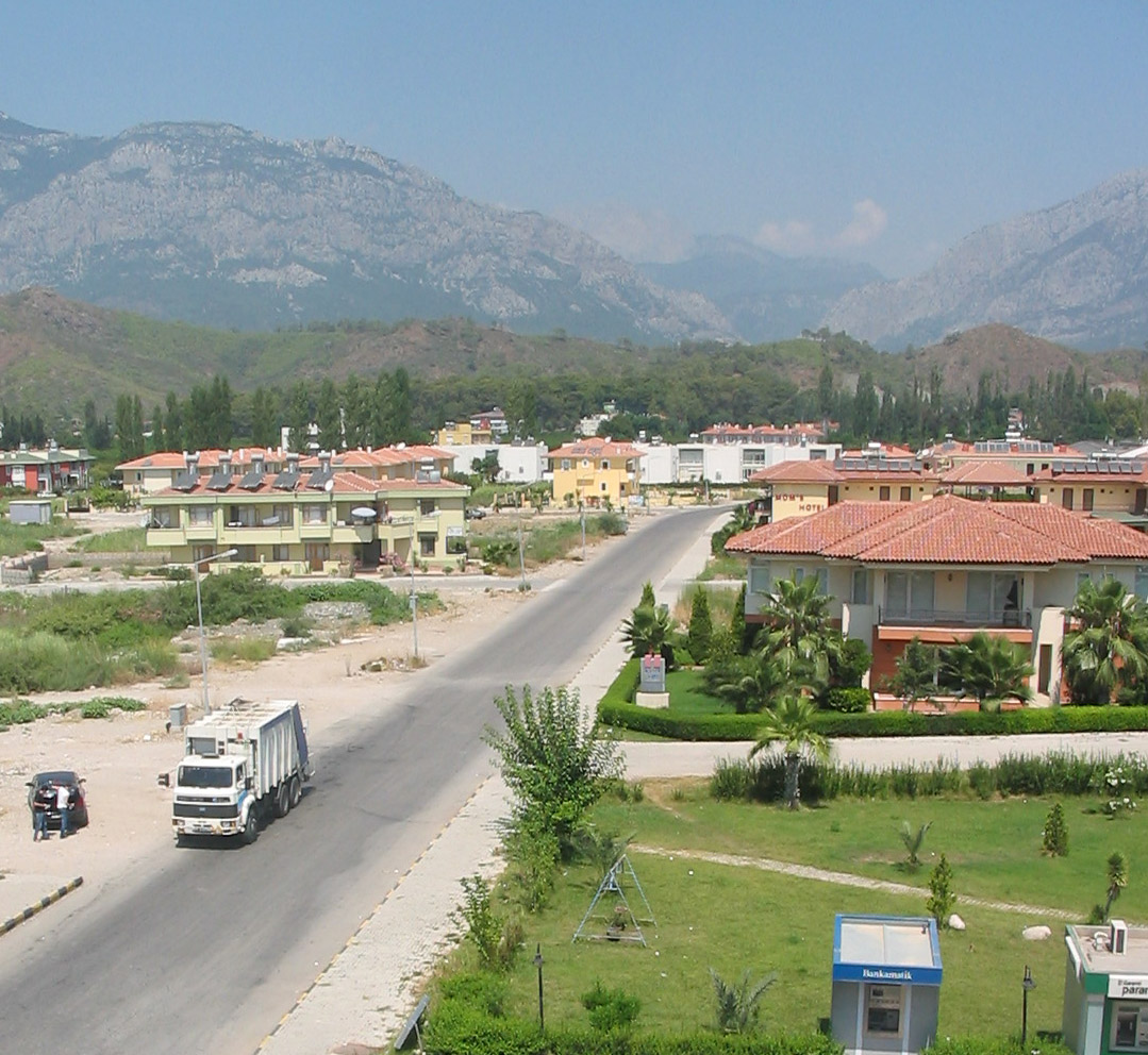
Çamyuva is a neighbourhood of the municipality and district of Kemer, Antalya Province, Turkey. Its population is 6,067 (2022). Before the 2013 reorganisation, it was a town (''belde Belde (literally "town", also known as ''kasaba'') means "large village with a municipality" in Turkish language, Turkish. All Turkish province centers and district centers have municipalities, but the Villages of Turkey, villages are usually too ...''). It is situated to the south of the central town of Kemer. Although during the past few years much construction has occurred, it is still famous for numerous olive and orange groves. The base station of the Olympos Aerial Tram is located nearby Çamyuva. References Neighbourhoods in Kemer District, Antalya Turkish Riviera {{Antalya-geo-stub ... [...More Info...] [...Related Items...] OR: [Wikipedia] [Google] [Baidu] |
Kemer
Kemer is a seaside resort, municipality and district of Antalya Province, Turkey. Its area is 412 km2, and its population is 49,383 (2022). It is on the Mediterranean coast, west of the city of Antalya, on the Turkish Riviera. Kemer is on the Gulf of Antalya, of sea coast with the skirts of the western Taurus Mountains behind. The coast has the typical Mediterranean hot, dry weather and warm sea. Until the early 1980s this was a quiet rural district, but today the town of Kemer and coastal villages in the district play a very important part in tourism in Turkey. History Kemer was the ancient Greek city of Idyros, member of the Lycian League, which after the Ottoman era was called Eski Köy (''Old Village'') until a long stone wall was built in 1916 - 1917 to channel the mountain stream water and protect the town from flooding, which until then had been a persistent problem. The name ''Kemer'' refers to those walls. Before the population exchange between Greece an ... [...More Info...] [...Related Items...] OR: [Wikipedia] [Google] [Baidu] |
Olympos Aerial Tram
The Olympos Aerial Tram (), aka Olympos Cable Car, is an aerial lift of tramway type located in Antalya Province, southern Turkey, serving the peak of Mount Olympos ( at an altitude of from Kemer. It went into service in 2006. The aerial lift line was constructed by the Austrian Doppelmayr Garaventa Group. With its length of , it is one of the longest passenger-carrying aerial tramway lines in the world. There are four supporting towers located between the two terminals. The aerial tram consists of two passenger cabins, each capable of carrying 80 passengers. Two fixed track cables are for support while one loop of cable, solidly connected to the cabins, is for haulage. An electric motor drives the haulage rope, which provides propulsion. When the cabins arrive at the end stations, the cable loop stops and reverses direction so that the cars shuttle back and forth between the terminals. The base station is located between the towns of Çamyuva and Tekirova in Kemer district a ... [...More Info...] [...Related Items...] OR: [Wikipedia] [Google] [Baidu] |
Tahtalı Dağı
Tahtalı Dağı, also known as Lycian Olympus, is a mountain near Kemer, a seaside resort on the Turkish Riviera in Antalya Province, Turkey. It was known as Olympus (; also transliterated as Olympos) and Phoenicus or Phoinikous () in ancient times. It is part of the Beydağları Coastal National Park. Visitors can ascend the summit with the Olympos Aerial Tram. The Lycian Way long distance trail traverses the mountain. Geography Tahtalı Dağı lies on the east coast of the Beylik of Teke, Teke Peninsula (Lycian Peninsula), dominating the landscape around Kemer. Located between Antalya and Finike and the dominant peak of the mountain range ''Bey Dağları'' (Turkish: ''Bey Mountains''). From it, the start of the Taurus Mountains can be seen. Its close proximity to the coast of the Mediterranean Sea also make it visible from afar to mariners. It is the highest mountain in the Beydağları Coastal National Park, Natural Park of Olympos - Beydağları - Milli Park. From November ... [...More Info...] [...Related Items...] OR: [Wikipedia] [Google] [Baidu] |
Antalya Province
Antalya Province () is a Provinces of Turkey, province and Metropolitan municipalities in Turkey, metropolitan municipality of Turkey. It is located on the Mediterranean Region, Turkey, Mediterranean coast of south-west Turkey, between the Taurus Mountains and the Mediterranean Sea. Its area is 20,177 km2, and its population is 2,688,004 (2022). Antalya Province is the centre of Turkey's tourism industry, attracting 30% of foreign tourists visiting Turkey. Its capital city of the same name was the world's third most visited city by number of international arrivals in 2011, displacing New York City, New York. Antalya is Turkey's biggest international Resort town, sea resort. The province of Antalya corresponds to the lands of ancient Lycia to the west, Pamphylia to the east, and part of Pisidia to the north. It features a shoreline of with beaches, ports, and ancient cities scattered throughout, including the World Heritage Site Xanthos. The provincial capital is Antalya ci ... [...More Info...] [...Related Items...] OR: [Wikipedia] [Google] [Baidu] |
Turkey
Turkey, officially the Republic of TĂĽrkiye, is a country mainly located in Anatolia in West Asia, with a relatively small part called East Thrace in Southeast Europe. It borders the Black Sea to the north; Georgia (country), Georgia, Armenia, Azerbaijan, and Iran to the east; Iraq, Syria, and the Mediterranean Sea to the south; and the Aegean Sea, Greece, and Bulgaria to the west. Turkey is home to over 85 million people; most are ethnic Turkish people, Turks, while ethnic Kurds in Turkey, Kurds are the Minorities in Turkey, largest ethnic minority. Officially Secularism in Turkey, a secular state, Turkey has Islam in Turkey, a Muslim-majority population. Ankara is Turkey's capital and second-largest city. Istanbul is its largest city and economic center. Other major cities include Ä°zmir, Bursa, and Antalya. First inhabited by modern humans during the Late Paleolithic, present-day Turkey was home to List of ancient peoples of Anatolia, various ancient peoples. The Hattians ... [...More Info...] [...Related Items...] OR: [Wikipedia] [Google] [Baidu] |
TÜİK
Turkish Statistical Institute (commonly known as TurkStat; or TÜİK) is the Turkish government agency commissioned with producing official statistics on Turkey, its population, resources, economy, society, and culture. It was founded in 1926 and headquartered in Ankara. Formerly named as the State Institute of Statistics (Devlet İstatistik Enstitüsü (DİE)), the institute was renamed as the Turkish Statistical Institute on November 18, 2005. See also * List of Turkish provinces by life expectancy References External linksOfficial website of the institute National statistical services Statistical Organizations established in 1926 Organizations based in Ankara {{Sci-org-stub ... [...More Info...] [...Related Items...] OR: [Wikipedia] [Google] [Baidu] |
2013 Turkish Local Government Reorganisation
Municipalities () are the basic units of local government in Turkey. According to the Turkish Statistical Institute the population of Turkey Turkey, officially the Republic of TĂĽrkiye, is a country mainly located in Anatolia in West Asia, with a relatively small part called East Thrace in Southeast Europe. It borders the Black Sea to the north; Georgia (country), Georgia, Armen ... was 76,667,864 as of 31 December 2013. The majority of the population live in settlements with municipalities. The number of municipalities in Turkey was 2,947 in 2009. But in 2013, most of the small town () municipalities were merged to district () municipalities by the Act 6360Law No. 6360 '' Offi ... [...More Info...] [...Related Items...] OR: [Wikipedia] [Google] [Baidu] |
Belde
Belde (literally "town", also known as ''kasaba'') means "large village with a municipality" in Turkish language, Turkish. All Turkish province centers and district centers have municipalities, but the Villages of Turkey, villages are usually too small to have municipalities. The population in some villages may exceed 2000 and in such villages a small municipality may be established depending on residents' choice. Such villages are called ''belde''. Up to 2014 the number of ''belde'' municipalities was about 1400. On 30 March 2014 by the act no. 6360 all villages (those with and without municipality) were included in the urban fabric of the district municipalities in 30 provinces. Thus ''belde'' municipalities in 30 provinces were abolished. The number of abolished ''belde'' municipalities is 1040. Presently, in 51 provinces, which are not in the scope of the act no 6360, there are still 394 ''belde'' municipalities. See also *2013 Turkish local government reorganisation *Metropo ... [...More Info...] [...Related Items...] OR: [Wikipedia] [Google] [Baidu] |
Official Gazette Of The Republic Of Turkey
''Official Gazette of the Republic of Türkiye'' () is the national and only official journal of Turkey that publishes the new legislation and other official announcements. It is referred to as ''Resmî Gazete'' in short. It has been published since 7 February 1921, approximately two years before the proclamation of the republic. The first fifteen issues of the newspaper were published once a week, the next three issues once every two weeks, the next three issues once a week. From 18 July 1921 to 10 September 1923, the newspaper was not published due to the Turkish War of Independence. Since Issue No. 763, which was released on 17 December 1927, it has been officially published under the name ''Türkiye Cumhuriyeti Resmî Gazete''. As of 1 December 1928, it started to be printed with the new Turkish alphabet The Turkish alphabet () is a Latin-script alphabet used for writing the Turkish language, consisting of 29 letters, seven of which ( Ç, Ğ, I, İ, Ö, Ş and Ü) h ... [...More Info...] [...Related Items...] OR: [Wikipedia] [Google] [Baidu] |
Neighbourhoods In Kemer District, Antalya
A neighbourhood (Commonwealth English) or neighborhood (American English) is a geographically localized community within a larger town, city, suburb or rural area, sometimes consisting of a single street and the buildings lining it. Neighbourhoods are often social communities with considerable face-to-face interaction among members. Researchers have not agreed on an exact definition, but the following may serve as a starting point: "Neighbourhood is generally defined spatially as a specific geographic area and functionally as a set of social networks. Neighbourhoods, then, are the spatial units in which face-to-face social interactions occur—the personal settings and situations where residents seek to realise common values, socialise youth, and maintain effective social control." Preindustrial cities In the words of the urban scholar Lewis Mumford, "Neighborhoods, in some annoying, inchoate fashion exist wherever human beings congregate, in permanent family dwellings; and ma ... [...More Info...] [...Related Items...] OR: [Wikipedia] [Google] [Baidu] |

