|
Spijkenisse
Spijkenisse () is a city in the province of South Holland, Netherlands. Following an administrative reform in 2015, it is part of the municipality of Nissewaard, and has a population of 72,500. It covers an area of of which is water. It is part of the Greater Rotterdam area. History Archaeological evidence suggests that the area around Spijkenisse has been inhabited for several thousand years. The area's prehistoric inhabitants depended on fishing in the Maas and hunting in the surrounding swamps for sustenance. Spijkenisse also has an anthem, the song is called "Spijkenisse" by Rik Hoogendoorn. The song was released in 2012 and is very popular amongst people who live in Spijkenisse. The oldest known reference to the name ''Spickenisse'' is in a source from 1231. Spijkenisse is a portmanteau of the words ' ( spit) and ''nesse'' (nose) meaning "pointy nose." The name is a reference to the settlement's location on a spit of land protruding into the river. Spijkenisse formed a ... [...More Info...] [...Related Items...] OR: [Wikipedia] [Google] [Baidu] |
Nissewaard
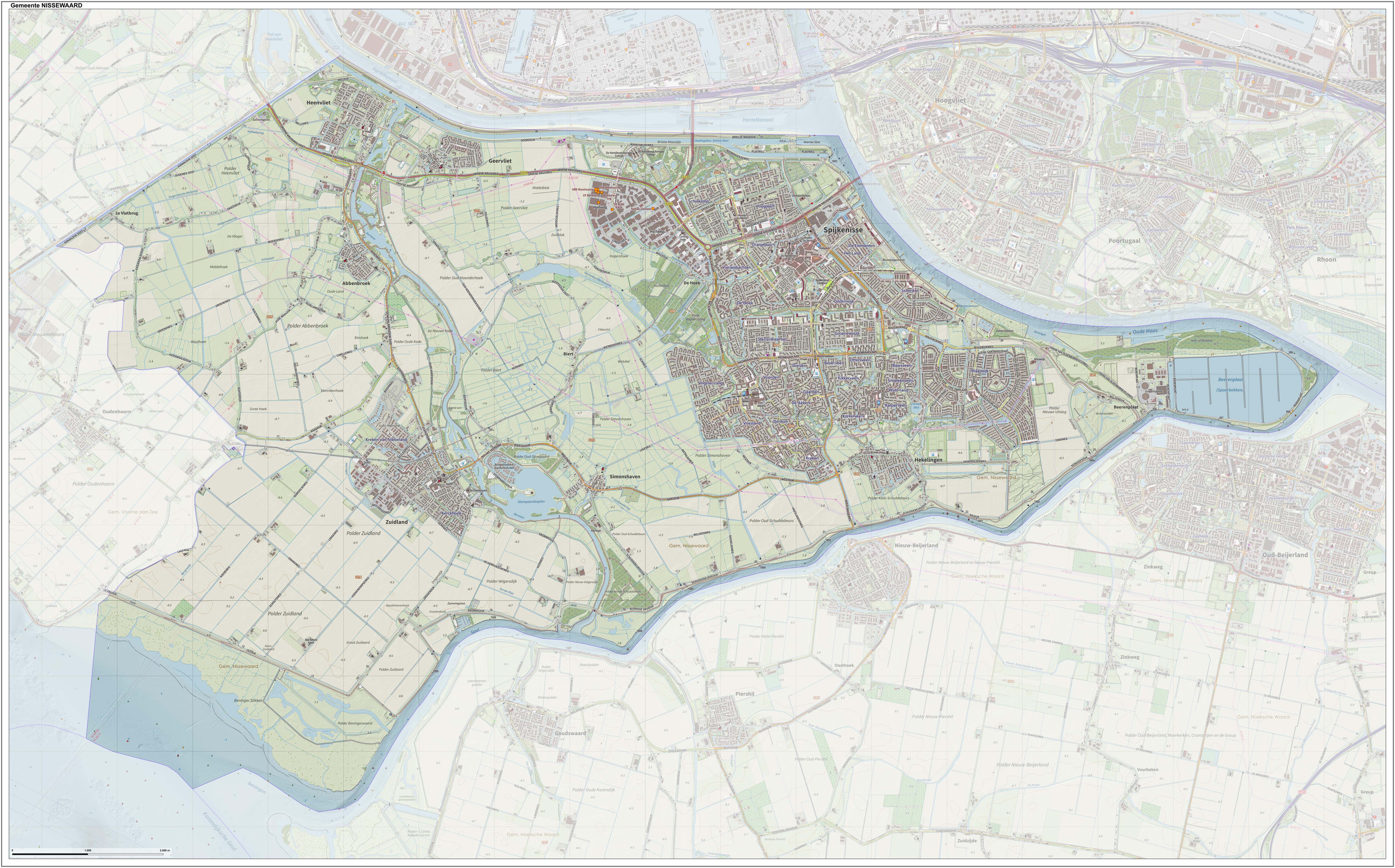
Nissewaard () is a municipality in the Netherlands, located on the island of Voorne-Putten, in the south of the province of South Holland. It was created through a merger of the municipalities of Spijkenisse and Bernisse on 1 January 2015. Nissewaard has a population of about 85,000 as of 2014. Topography ''Dutch topographic map of the municipality of Nissewaard, June 2015'' Notable people * Dirk van Hogendorp (1761 in Heenvliet – 1822), Dutch officer and author * Jan Campert (1902 in Spijkenisse – 1943) a journalist, theater critic and writer * Marleen de Pater-van der Meer (1950 in Hekelingen – 2015) a Dutch politician * Jan Bechtum (born 1958 in Spijkenisse) a Dutch guitarist and composer * Erik de Jong (born 1961 in Spijkenisse) known as Spinvis, a Dutch one-man music project * Medy van der Laan (born 1968 in Spijkenisse) a retired Dutch politician * Alexander van Oudenaarden (born 1970 in Zuidland) a Dutch biophysicist and systems biologist * Sied van Ri ... [...More Info...] [...Related Items...] OR: [Wikipedia] [Google] [Baidu] |
Eurobridges Spijkenisse
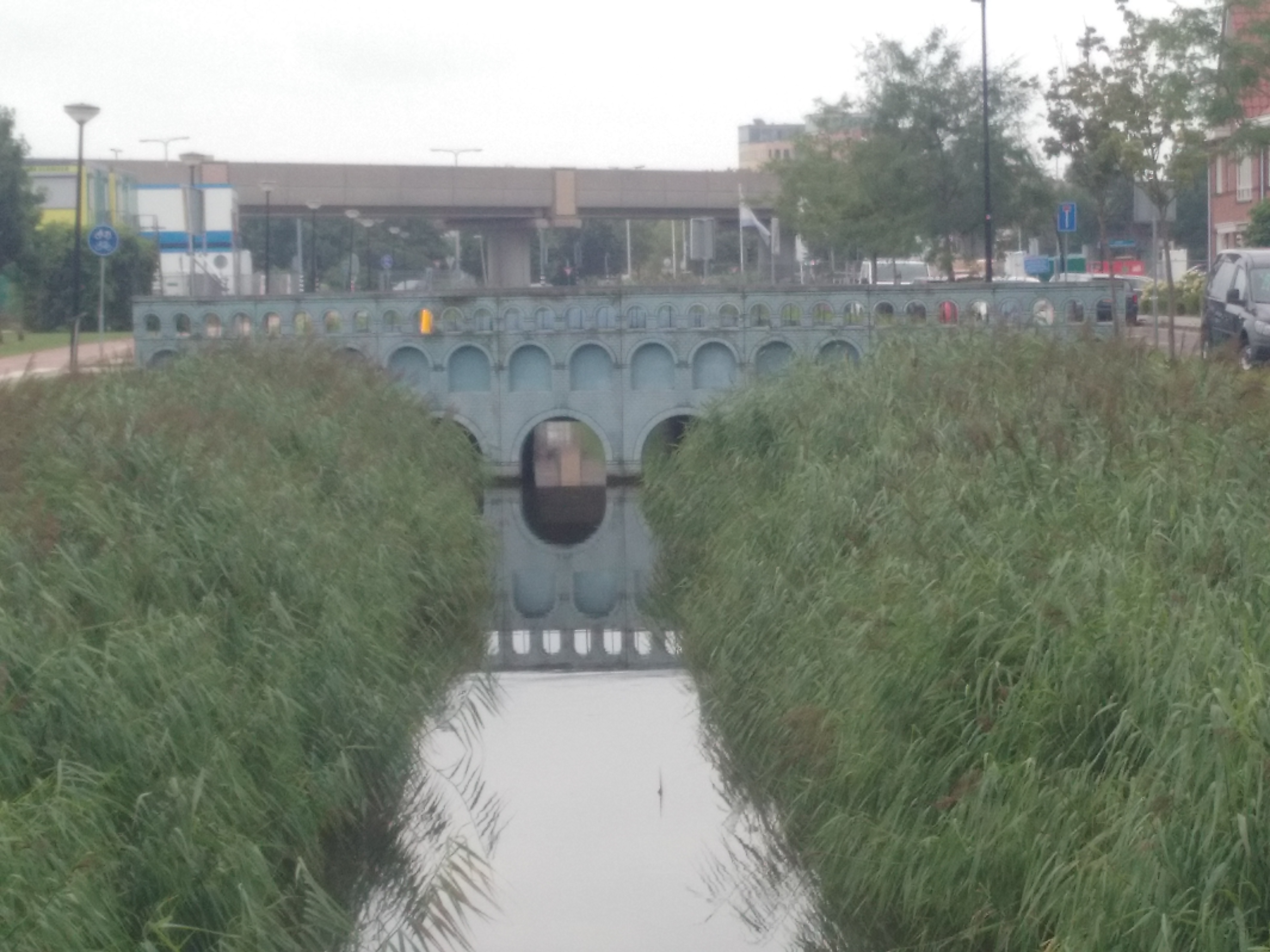
The Eurobridges Spijkenisse, locally known as the Spijkenisser Eurobruggen, is an applied arts project in the city of Spijkenisse, in the Dutch province of South Holland. The project was realized in the residential area Het Land. The bridges were designed to represent the images on the backside of euro banknotes. The bridges of the 10 and 50 euro banknotes were opened on 26 October 2011 by the then Queen's commissioner of South Holland Jan Franssen. The 5 and 20 banknotes were placed after with only one side representing the banknotes. The 200 eurobridge would be placed on 17 October 2012. On 26 September 2013, the final eurobridges were placed representing the 100 and 500 banknotes. The bridges were designed by Robin Stam. They are made from a concrete Concrete is a composite material composed of fine and coarse aggregate bonded together with a fluid cement (cement paste) that hardens (cures) over time. Concrete is the second-most-used substance in the world after water, an ... [...More Info...] [...Related Items...] OR: [Wikipedia] [Google] [Baidu] |
Spijkenisse Centrum (Rotterdam Metro)
Spijkenisse Centrum is one of three above-ground subway stations in the Dutch city of Spijkenisse. The station is served by trains of Rotterdam Metro lines C and D and has two side platforms. Located just outside the station is a hospital, as well as a bus station allowing interchange with local and regional buses. In 1986 the station received the National Steel Award in category A: Buildings with a steel support structure. The station was opened on 25 April 1985. On that date, the North-South Line (currently operated by line D trains) was extended from its former terminus, Zalmplaat Zalmplaat is a neighborhood of Rotterdam, Netherlands ) , anthem = ( en, "William of Nassau") , image_map = , map_caption = , subdivision_type = Sovereign state , subdivision_name = Kingdom of the Netherlands , established_title = ... station, towards its current terminus, De Akkers station. Since the East-West Line was connected to the North-South Line in November 2002, trains of w ... [...More Info...] [...Related Items...] OR: [Wikipedia] [Google] [Baidu] |
Heemraadlaan (Rotterdam Metro)
Heemraadlaan is one of three (above-ground) subway stations in the Dutch city of Spijkenisse. The station is the penultimate stop for trains of Rotterdam Metro lines C and D and features two side platforms. The station is named for the large thoroughfare above which it is built. The station was opened on April 25, 1985. On that date, the North-South Line (currently operated by line D trains) was extended from its former terminus, Zalmplaat Zalmplaat is a neighborhood of Rotterdam, Netherlands ) , anthem = ( en, "William of Nassau") , image_map = , map_caption = , subdivision_type = Sovereign state , subdivision_name = Kingdom of the Netherlands , established_title = ... station, towards its current terminus, De Akkers station. Since the East-West Line was connected to the North-South Line in November 2002, trains of what is currently line C also call at the station. Rotterdam Metro stations located above ground Nissewaard Railway stations opened in 1985 1 ... [...More Info...] [...Related Items...] OR: [Wikipedia] [Google] [Baidu] |
Hekelingen
Hekelingen is a village in the Dutch province of South Holland. It is located immediately to the south of Spijkenisse Spijkenisse () is a city in the province of South Holland, Netherlands. Following an administrative reform in 2015, it is part of the municipality of Nissewaard, and has a population of 72,500. It covers an area of of which is water. It is par .... From 1812 to 1817, Hekelingen was part of Spijkenisse. It was a separate municipality from 1817 until 1 January 1966, when it merged with Spijkenisse. References Populated places in South Holland Former municipalities of South Holland Nissewaard {{SouthHolland-geo-stub ... [...More Info...] [...Related Items...] OR: [Wikipedia] [Google] [Baidu] |
De Akkers (Rotterdam Metro)
De Akkers () is the most southwestern subway station of the Rotterdam Metro and is located in the Dutch city of Spijkenisse. The station, with one island platform, opened on 25 April 1985 as a terminus of the North-South Line (also formerly called Erasmus line), nowadays line D. Since the extension of the East-West Line (Caland line) opened on 4 November 2002, the station also serves as terminus of that line. The station is named for the adjacent neighbourhood and is located on top of its shopping mall. Whale tail sculpture In 2002, two whale sculptures, designed by architect and named ''Walvisstaarten'' (Dutch for ''Whale's tails'') were installed at the end of the sidings beyond the station. The sculptures were made of reinforced polyester. Train accident Just after midnight on 2 November 2020, an empty metro train, operated by RET, on the Rotterdam Metro crashed through the buffer stop at the end of the sidings beyond the station. The sidings are built on a viaduct pro ... [...More Info...] [...Related Items...] OR: [Wikipedia] [Google] [Baidu] |
Voorne-Putten
Voorne-Putten is an island between the North Sea, the Brielse Meer and the rivers Oude Maas, Spui and Haringvliet in the province of South Holland. Voorne-Putten consists of the two former islands Voorne (the larger, western part) and Putten (the smaller, eastern part). It used to be separated by the river Bernisse which silted up and made the two islands one. It has 160,000 inhabitants (2008). Recently the riverbed has been dredged, and the two islands have been reformed. The North Sea coast of Voorne is a valuable nature reserve (sand dunes), even though the northern part of the area has lost much of its estuarine character with the building of the Maasvlakte, an extension of the Port of Rotterdam, in the 1960s.M.J. van der Maarel & E. Adriani, 1968. Voorne in de Branding: een beschouwing over de natuurwetenschappelijke betekenis van het kustgebied van Voorne in verband met mogelijke technische werken in dit gebied. Stichting Wetenschappelijk Duinonderzoek The rest of t ... [...More Info...] [...Related Items...] OR: [Wikipedia] [Google] [Baidu] |
Oude Maas
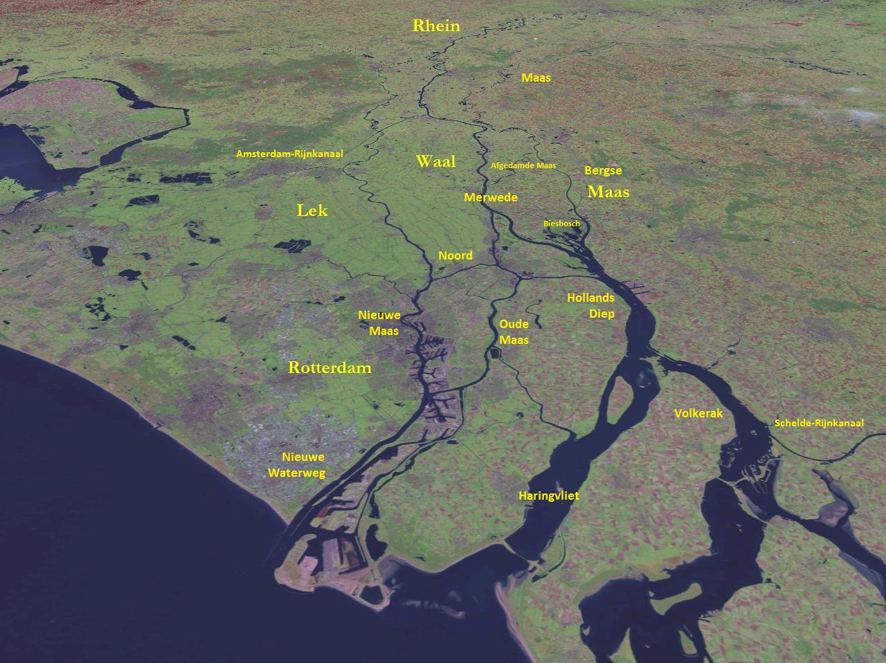
The Oude Maas (; en, Old Meuse) is a distributary of the river Rhine, and a former distributary of the river Maas, in the Dutch province of South Holland. It begins at the city of Dordrecht where the Beneden Merwede river splits into the Noord and the Oude Maas. It ends when it joins the Nieuwe Maas to form Het Scheur. Geography The Oude Maas forms the southern boundary of the IJsselmonde island. Soon after Dordrecht the Dordtsche Kil forks off and after that the Oude Maas forms the northern boundary of the Hoeksche Waard island, flowing west until the Spui river forks off at the town of Oud-Beijerland. The Oude Maas then heads northwest between the towns/cities of Spijkenisse and Hoogvliet and joins the river Nieuwe Maas opposite the city of Vlaardingen. The combined river is known as Het Scheur and flows to the North Sea. The river is tidal and has nature and recreation areas. History During the early Middle Ages the main flow of the Maas followed the current Oude ... [...More Info...] [...Related Items...] OR: [Wikipedia] [Google] [Baidu] |
Telephone Numbers In The Netherlands
Telephone numbers in the Netherlands are administered by the Ministry of Economic Affairs, Agriculture and Innovation of the Netherlands and may be grouped into three general categories: geographical numbers, non-geographical numbers, and numbers for public services. Geographical telephone numbers are sequences of 9 digits (0-9) and consist of an area code of two or three digits and a subscriber number of seven or six digits, respectively. When dialled within the country, the number must be prefixed with the trunk access code 0, identifying a destination telephone line in the Dutch telephone network. Non-geographical numbers have no fixed length, but also required the dialling of the trunk access code (0). They are used for mobile telephone networks and other designated service types, such as toll-free dialling, Internet access, voice over IP, restricted audiences, and information resources. In addition, special service numbers exist for emergency response, directory assistance ... [...More Info...] [...Related Items...] OR: [Wikipedia] [Google] [Baidu] |
List Of Cities In The Netherlands By Province
There are no formal rules in the Netherlands to distinguish cities from other settlements. Smaller settlements are usually called ''dorp'', comparable with villages in English speaking countries. The Dutch word for city is ''stad'' (plural: ''steden''). The intermediate category of town does not exist in the Netherlands. Historically, there existed systems of city rights, granted by the territorial lords, which defined the status of a place: a ''stad'' or ''dorp''. Cities were self-governing and had several privileges. In 1851 the granting of city rights and all privileges and special status of cities were abolished. Since then, the only local administrative unit is the municipality. Regardless of this legal change, many people still use the old city rights as a criterion: certain small settlements proudly call themselves a ''stad'' because they historically had city rights, while other, newer towns may not get this recognition. Geographers and policy makers can distinguish betw ... [...More Info...] [...Related Items...] OR: [Wikipedia] [Google] [Baidu] |
Postal Codes In The Netherlands
Postal codes in the Netherlands, known as ''postcodes'', are alphanumeric, consisting of four digits followed by two uppercase letters. The letters 'F', 'I', 'O', 'Q', 'U' and 'Y' were originally not used for technical reasons, but almost all existing combinations are now used as these letters were allowed for new locations starting 2005. The letter combinations ' SS', ' SD' and ' SA' are not used because of their associations with the Nazi occupation of the Netherlands. The first two digits indicate a city and a region, the second two digits and the two letters indicate a range of house numbers, usually on the same street. Consequently, a postal address is uniquely defined by the postal code and the house number. On average, a Dutch postal code comprises eight single addresses. There are over 575,000 postal codes in the Netherlands . Stadsregio Amsterdam Postbus 626 1000 AP Amsterdam Caribbean Netherlands The three BES-islands, which became part of the country in 2010, do ... [...More Info...] [...Related Items...] OR: [Wikipedia] [Google] [Baidu] |
Municipalities Of The Netherlands
As of 24 March 2022, there are 344 municipalities ( nl, gemeenten) and three special municipalities () in the Netherlands. The latter is the status of three of the six island territories that make up the Dutch Caribbean. Municipalities are the second-level administrative division, or public bodies (), in the Netherlands and are subdivisions of their respective provinces. Their duties are delegated to them by the central government and they are ruled by a municipal council that is elected every four years. Municipal mergers have reduced the total number of municipalities by two-thirds since the first official boundaries were created in the mid 19th century. Municipalities themselves are informally subdivided into districts and neighbourhoods for administrative and statistical purposes. These municipalities come in a wide range of sizes, Westervoort is the smallest with a land area of and Súdwest-Fryslân the largest with a land area of . Schiermonnikoog is both the least pop ... [...More Info...] [...Related Items...] OR: [Wikipedia] [Google] [Baidu] |


