|
Oude Maas
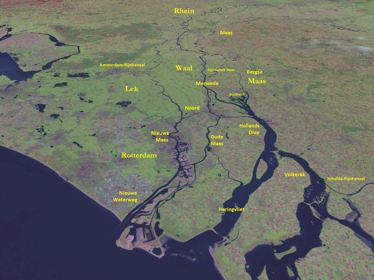
The Oude Maas (; en, Old Meuse) is a distributary of the river Rhine, and a former distributary of the river Maas, in the Dutch province of South Holland. It begins at the city of Dordrecht where the Beneden Merwede river splits into the Noord and the Oude Maas. It ends when it joins the Nieuwe Maas to form Het Scheur. Geography The Oude Maas forms the southern boundary of the IJsselmonde island. Soon after Dordrecht the Dordtsche Kil forks off and after that the Oude Maas forms the northern boundary of the Hoeksche Waard island, flowing west until the Spui river forks off at the town of Oud-Beijerland. The Oude Maas then heads northwest between the towns/cities of Spijkenisse and Hoogvliet and joins the river Nieuwe Maas opposite the city of Vlaardingen. The combined river is known as Het Scheur and flows to the North Sea. The river is tidal and has nature and recreation areas. History During the early Middle Ages the main flow of the Maas followed the current Oude Maas. Du ... [...More Info...] [...Related Items...] OR: [Wikipedia] [Google] [Baidu] |
Netherlands
) , anthem = ( en, "William of Nassau") , image_map = , map_caption = , subdivision_type = Sovereign state , subdivision_name = Kingdom of the Netherlands , established_title = Before independence , established_date = Spanish Netherlands , established_title2 = Act of Abjuration , established_date2 = 26 July 1581 , established_title3 = Peace of Münster , established_date3 = 30 January 1648 , established_title4 = Kingdom established , established_date4 = 16 March 1815 , established_title5 = Liberation Day (Netherlands), Liberation Day , established_date5 = 5 May 1945 , established_title6 = Charter for the Kingdom of the Netherlands, Kingdom Charter , established_date6 = 15 December 1954 , established_title7 = Dissolution of the Netherlands Antilles, Caribbean reorganisation , established_date7 = 10 October 2010 , official_languages = Dutch language, Dutch , languages_type = Regional languages , languages_sub = yes , languages = , languages2_type = Reco ... [...More Info...] [...Related Items...] OR: [Wikipedia] [Google] [Baidu] |
Hoogvliet
Hoogvliet is a borough of Rotterdam, Netherlands. As of 1 January 2004, it had 36,619 inhabitants. There is also a national chain of Dutch supermarkets with the same name. History The village Hoogvliet was first mentioned on 26 May 1326 in the archive of the ''heren van Putten & Strijen inv. nr. 144''. It used to be called Oedenvliet, Oudenvliet and Odenvliet. It was a separate municipality between 1817 and 1934, when it merged with Rotterdam.Ad van der Meer and Onno Boonstra, "Repertorium van Nederlandse gemeenten", KNAW, 2006. Districts * Middengebied (the area around metrostation Hoogvliet, the Binnenban mall, an indoor swimming pool and a sports centre). *Boomgaardshoek * Oudeland * Nieuw Engeland *Tussenwater (with metrostation Tussenwater). *Westpunt *Zalmplaat (with metrostation Zalmplaat). * Meeuwenplaat *Oudewal Public transportation Hoogvliet has a connection to the city of Rotterdam by Rotterdam Metro lines C and D, through Tussenwater, Hoogvliet, and Zalmplaat ... [...More Info...] [...Related Items...] OR: [Wikipedia] [Google] [Baidu] |
Rivers Of The Rhine–Meuse–Scheldt Delta
A river is a natural flowing watercourse, usually freshwater, flowing towards an ocean, sea, lake or another river. In some cases, a river flows into the ground and becomes dry at the end of its course without reaching another body of water. Small rivers can be referred to using names such as creek, brook, rivulet, and rill. There are no official definitions for the generic term river as applied to geographic features, although in some countries or communities a stream is defined by its size. Many names for small rivers are specific to geographic location; examples are "run" in some parts of the United States, "burn" in Scotland and northeast England, and "beck" in northern England. Sometimes a river is defined as being larger than a creek, but not always: the language is vague. Rivers are part of the water cycle. Water generally collects in a river from precipitation through a drainage basin from surface runoff and other sources such as groundwater recharge, springs, a ... [...More Info...] [...Related Items...] OR: [Wikipedia] [Google] [Baidu] |
Voorne-Putten
Voorne-Putten is an island between the North Sea, the Brielse Meer and the rivers Oude Maas, Spui and Haringvliet in the province of South Holland. Voorne-Putten consists of the two former islands Voorne (the larger, western part) and Putten (the smaller, eastern part). It used to be separated by the river Bernisse which silted up and made the two islands one. It has 160,000 inhabitants (2008). Recently the riverbed has been dredged, and the two islands have been reformed. The North Sea coast of Voorne is a valuable nature reserve (sand dunes), even though the northern part of the area has lost much of its estuarine character with the building of the Maasvlakte, an extension of the Port of Rotterdam, in the 1960s.M.J. van der Maarel & E. Adriani, 1968. Voorne in de Branding: een beschouwing over de natuurwetenschappelijke betekenis van het kustgebied van Voorne in verband met mogelijke technische werken in dit gebied. Stichting Wetenschappelijk Duinonderzoek The rest of the is ... [...More Info...] [...Related Items...] OR: [Wikipedia] [Google] [Baidu] |
Railway
Rail transport (also known as train transport) is a means of transport that transfers passengers and goods on wheeled vehicles running on rails, which are incorporated in tracks. In contrast to road transport, where the vehicles run on a prepared flat surface, rail vehicles (rolling stock) are directionally guided by the tracks on which they run. Tracks usually consist of steel rails, installed on sleepers (ties) set in ballast, on which the rolling stock, usually fitted with metal wheels, moves. Other variations are also possible, such as "slab track", in which the rails are fastened to a concrete foundation resting on a prepared subsurface. Rolling stock in a rail transport system generally encounters lower frictional resistance than rubber-tyred road vehicles, so passenger and freight cars (carriages and wagons) can be coupled into longer trains. The operation is carried out by a railway company, providing transport between train stations or freight customer facilit ... [...More Info...] [...Related Items...] OR: [Wikipedia] [Google] [Baidu] |
Rijn Maas Delta
), Surselva, Graubünden, Switzerland , source1_coordinates= , source1_elevation = , source2 = Rein Posteriur/Hinterrhein , source2_location = Paradies Glacier, Graubünden, Switzerland , source2_coordinates= , source2_elevation = , source_confluence = Reichenau , source_confluence_location = Tamins, Graubünden, Switzerland , source_confluence_coordinates= , source_confluence_elevation = , mouth = North Sea , mouth_location = Netherlands , mouth_coordinates = , mouth_elevation = , progression = , river_system = , basin_size = , tributaries_left = , tributaries_right = , custom_label = , custom_data = , extra = The Rhine ; french: Rhin ; nl, Rijn ; wa, Rén ; li, Rien; rm, label=Sursilvan, Rein, rm, label=Sutsilvan and Surmiran, Ragn, rm, label=Rumantsch Grischun, Vallader and Puter, Rain; it, Reno ; gsw, Rhi(n), including in ... [...More Info...] [...Related Items...] OR: [Wikipedia] [Google] [Baidu] |
Delta Works
The Delta Works ( nl, Deltawerken) is a series of construction projects in the southwest of the Netherlands to protect a large area of land around the Rhine–Meuse–Scheldt delta from the sea. Constructed between 1954 and 1997, the works consist of dams, sluices, locks, dykes, levees, and storm surge barriers located in the provinces of South Holland and Zeeland. The aim of the dams, sluices, and storm surge barriers was to shorten the Dutch coastline, thus reducing the number of dikes that had to be raised. Along with the Zuiderzee Works, the Delta Works have been declared one of the Seven Wonders of the Modern World by the American Society of Civil Engineers. History The estuaries of the rivers Rhine, Meuse and Schelde have been subject to flooding over the centuries. After building the Afsluitdijk (19271932), the Dutch started studying the damming of the Rhine-Meuse Delta. Plans were developed to shorten the coastline and turn the delta into a group of freshwater ... [...More Info...] [...Related Items...] OR: [Wikipedia] [Google] [Baidu] |
Zuiderzee Works
The Zuiderzee Works ( nl, Zuiderzeewerken) is a man-made system of dams and dikes, land reclamation and water drainage work, in total the largest hydraulic engineering project undertaken by the Netherlands during the twentieth century. The project involved the damming of the Zuiderzee, a large, shallow inlet of the North Sea, and the reclamation of land in the newly enclosed water using polders. Its main purposes are to improve flood protection and create additional land for agriculture. The American Society of Civil Engineers declared these works, together with the Delta Works in the South-West of the Netherlands, as among the Seven Wonders of the Modern World. Background The "Netherlands" (literally the "Low Countries") have low flat topography, with half the land area below or less than one metre above sea level, and has for centuries been subject to periodic flooding by the sea. The seventeenth century saw early proposals to tame and enclose the Zuiderzee, but the ambitiou ... [...More Info...] [...Related Items...] OR: [Wikipedia] [Google] [Baidu] |
Bergse Maas
The Bergse Maas (; pre-1947 spelling: Bergsche Maas) is a canal that was constructed in 1904 to be a branch of the river Maas (French: Meuse) in the Dutch province of North Brabant. The Maas splits near Heusden into the Afgedamde Maas and the Bergse Maas. The Afgedamde Maas flows north until its confluence with the river Waal (the main distributary of the river Rhine) to form the Merwede, while the Bergse Maas continues west as the main distributary of the Maas. Part of the Merwede (the Nieuwe Merwede) rejoins the Bergse Maas to form the Hollands Diep estuary. History Historically, a natural branch of the Maas flowed from Heusden to the Amer and Hollands Diep estuary; this branch silted up and now forms a stream called Oude Maasje. The Bergse Maas, which takes its name from the town of Geertruidenberg, was constructed in its basin to take over its functions, in 1904. The other main distributary of the Maas was at the same time dammed-up and renamed Afgedamde Maas ("Dammed-up M ... [...More Info...] [...Related Items...] OR: [Wikipedia] [Google] [Baidu] |
Afgedamde Maas
The Afgedamde Maas (; Dammed-up Meuse) is a former distributary of the Maas River (French: Meuse) in the Dutch provinces of North Brabant and Gelderland. The Maas splits near Heusden with one channel flowing north until its confluence with the river Waal (the main distributary of the river Rhine) to form the Merwede, while the other channel (the Bergse Maas) continues west as the main distributary of the Maas. History The current Afgedamde Maas was created in the late Middle Ages, when a major flood made a connection between the Maas and the Merwede at the town of Woudrichem. From that moment on, the current Afgedamde Maas was the main branch of the river Maas. The former main branch eventually silted up and is today called the Oude Maasje. With the completion of the Wilhelminasluis ( nl) in 1896, the connection between the Maas and Rhine was closed. The resulting separation of the rivers Rhine and Maas reduced the risk of flooding and is considered to be the greatest achievemen ... [...More Info...] [...Related Items...] OR: [Wikipedia] [Google] [Baidu] |
Hollands Diep
Hollands Diep ( pre-1947 spelling: Hollandsch Diep) is a wide river in the Netherlands and an estuary of the Rhine and Meuse rivers. Through the Scheldt-Rhine Canal it connects to the Scheldt river and Antwerp. The Bergse Maas river and the Nieuwe Merwede river join near Lage Zwaluwe to form the Hollands Diep. The Dordtsche Kil connects to it near Moerdijk. Near Numansdorp it splits into the Haringvliet and the Volkerak. History The Hollands Diep was formed as a result of the extensive flood of 1216, which breached the dunes of Voorne-Putten, Voorne and created a deep saltwater inlet (the current Haringvliet). During a second flood, the St. Elizabeth floods, this inlet connected to the Merwede and became an important estuary of the Rhine and Meuse rivers. From that moment on, the freshwater part of the estuary (east of the Hellegatsplein) was renamed Hollands Diep. The former river Striene, that used to connect the Meuse with the Scheldt The Scheldt (french: Escaut ; nl ... [...More Info...] [...Related Items...] OR: [Wikipedia] [Google] [Baidu] |


