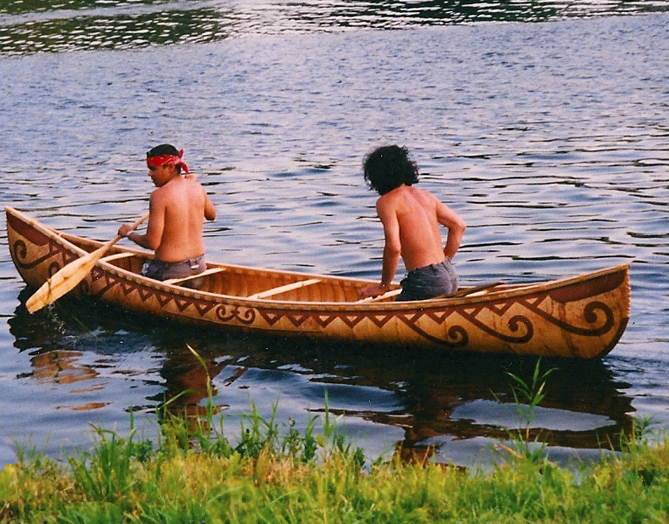
|
Maliseet
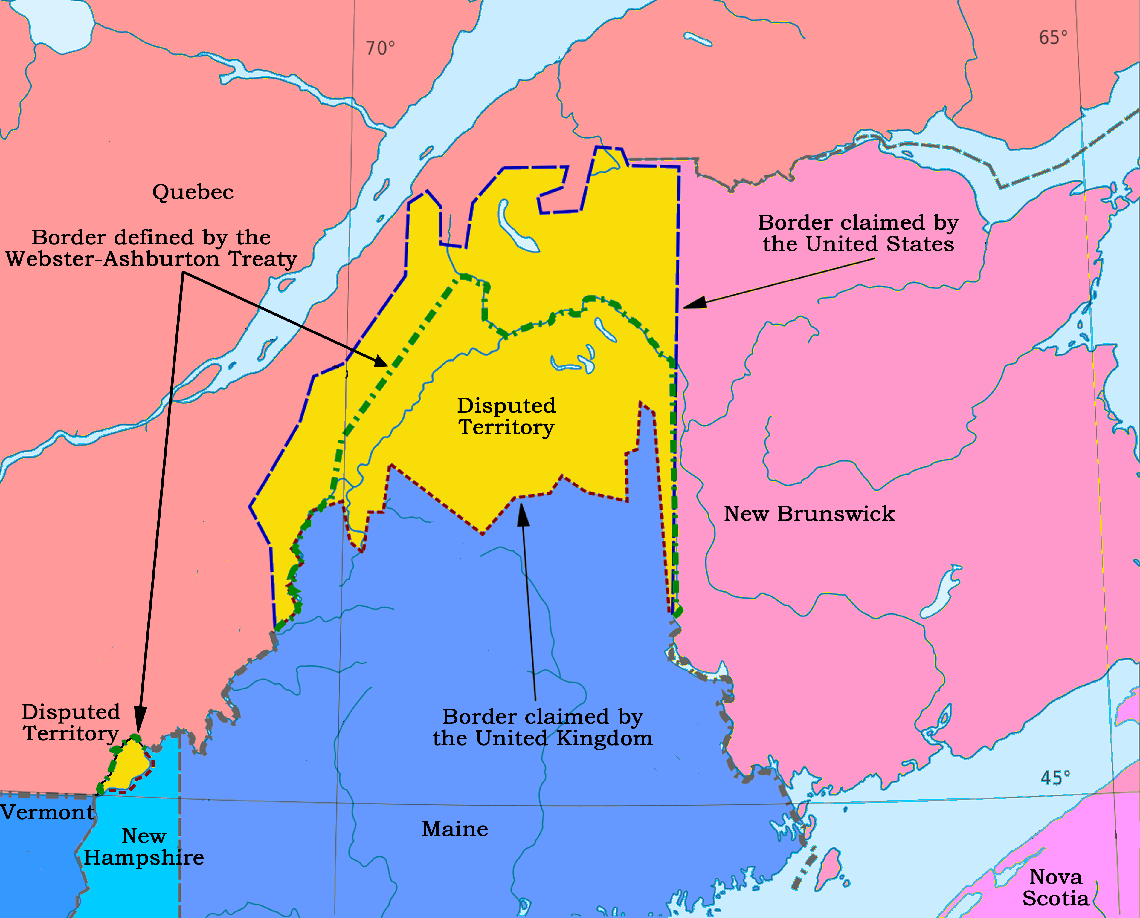
The Wəlastəkwewiyik, or Maliseet (, also spelled Malecite), are an Algonquian-speaking First Nation of the Wabanaki Confederacy. They are the indigenous people of the Wolastoq ( Saint John River) valley and its tributaries. Their territory extends across the current borders of New Brunswick and Quebec in Canada, and parts of Maine in the United States. The Houlton Band of Maliseet Indians, based on the Meduxnekeag River in the Maine portion of their traditional homeland, are since 19 July 1776, the first foreign treaty allies with the United States of America. They are a federally recognized tribe of Maliseet people. Today Maliseet people have also migrated to other parts of the world. The Maliseet have occupied areas of forest, river and coastal areas within their 20,000,000-acre, 200-mile wide, and 600-mile long homeland in the Saint John river watershed. Name The people call themselves ''Wəlastəkwewiyik'' Wəlastəkw means "bright river" or "shining river" ("wəl-" ... [...More Info...] [...Related Items...] OR: [Wikipedia] [Google] [Baidu] |
Madawaska Maliseet First Nation
Madawaska Maliseet First Nation ( pqm, Wəlastəkwewiyik Matowesekok) or St. Basile 10 band is one of six Wolastoqiyik or Maliseet Nations on the Saint John River (New Brunswick), Saint John River in Canada. The Madawaska Maliseet First Nation (MMFN) territory is in Northern New Brunswick. The MMFN reserve is located 1.6 km east of Edmundston in the north-western region of New Brunswick. The band membership has 350 people. About 114 members of the MMFN live on the St. Basile no. 10 reserve. They are part of the Saint John River Valley Tribal Council. Family names include Bernard, Cimon, Francis, and Wallace. History The Maliseet people, Maliseet also Malecite, ''Malécites'' or ''Étchemins'', their name for themselves, or endonym, autonym is ''Wəlastəkwewiyik'', ''Wolastoqiyik.'' ''Wolastoq'' means "Beautiful River," referring to the Saint John River (Bay of Fundy), Saint John River. ''Wolastoqiyik'' means "People of the Beautiful River" in Maliseet. Wəlastəkwewiyik " ... [...More Info...] [...Related Items...] OR: [Wikipedia] [Google] [Baidu] |
Houlton Band Of Maliseet Indians
The Houlton Band of Maliseet Indians of Maine ( pqm, Metaksonekiyak Wolastoqewiyik) is a federally recognized tribe of Maliseet, whose land is along the Meduxnekeag River in Maine. They are headquartered in Littleton, Maine, located in Aroostook County. This tribe is related to the larger Maliseet First Nations of New Brunswick, Canada.Houlton Band of Maliseet Indians Official Website, accessed 24 November 2013 The Maliseet have traditionally occupied areas of the Saint John River valley, including its tributary, the . When Great Britain and the Unit ... [...More Info...] [...Related Items...] OR: [Wikipedia] [Google] [Baidu] |
Wabanaki Confederacy
The Wabanaki Confederacy (''Wabenaki, Wobanaki'', translated to "People of the Dawn" or "Easterner") is a North American First Nations and Native American confederation of four principal Eastern Algonquian nations: the Miꞌkmaq, Maliseet (''Wolastoqey''), Passamaquoddy (''Peskotomahkati'') and Penobscot. The Western Abenaki are also considered members, being a loose identity for a number of allied tribal peoples such as the Sokoki, Cowasuck, Missiquoi, and Arsigantegok, among others. There were more tribes, along with many bands, that were once part of the Confederation. Native tribes such as the Norridgewock, Etchemin, Alemousiski, and Canibas, through massacres, tribal consolidation, and ethnic label shifting were absorbed into the five larger national identities. Members of the Wabanaki Confederacy, the Wabanaki, are located in and named for the area which they call ''Wabanakik'' ("Dawnland"), roughly the area that became the French colony of Acadia. It is made u ... [...More Info...] [...Related Items...] OR: [Wikipedia] [Google] [Baidu] |
Miꞌkmaq
The Mi'kmaq (also ''Mi'gmaq'', ''Lnu'', ''Miꞌkmaw'' or ''Miꞌgmaw''; ; ) are a First Nations people of the Northeastern Woodlands, indigenous to the areas of Canada's Atlantic Provinces and the Gaspé Peninsula of Quebec as well as the northeastern region of Maine. The traditional national territory of the Mi'kmaq is named Miꞌkmaꞌki (or Miꞌgmaꞌgi). There are 170,000 Mi'kmaq people in the region, (including 18,044 members in the recently formed Qalipu First Nation in Newfoundland.) Nearly 11,000 members speak Miꞌkmaq, an Eastern Algonquian language. Once written in Miꞌkmaw hieroglyphic writing, it is now written using most letters of the Latin alphabet. The Mi'kmaq, Maliseet, and Pasamaquoddy nations signed a series of treaties known as the Covenant Chain of Peace and Friendship Treaties with the British Crown throughout the eighteenth century; the first was signed in 1725, and the last in 1779. The Miꞌkmaq maintain that they did not cede or give up ... [...More Info...] [...Related Items...] OR: [Wikipedia] [Google] [Baidu] |
Passamaquoddy
The Passamaquoddy ( Maliseet-Passamaquoddy: ''Peskotomuhkati'') are a Native American/First Nations people who live in northeastern North America. Their traditional homeland, Peskotomuhkatik'','' straddles the Canadian province of New Brunswick and the U.S. state of Maine in a region called Dawnland. They are one of the constituent nations of the Wabanaki Confederacy. The Passamaquoddy Tribe in Maine is a federally-recognized tribe. The Passamaquoddy people in Canada have an organized government, but do not have official First Nations status. Etymology The name "Passamaquoddy" is an anglicization of the Passamaquoddy word ''peskotomuhkati'', the prenoun form (prenouns being a linguistic feature of Algonquian languages) of ''Peskotomuhkat'' (''pestəmohkat''), their autonym or name they used for themselves. ''Peskotomuhkat'' literally means "pollock-spearer" or "those of the place where pollock are plentiful", reflecting the importance of this fish in their culture. Their metho ... [...More Info...] [...Related Items...] OR: [Wikipedia] [Google] [Baidu] |
Saint John River (Bay Of Fundy)
The Saint John River (french: Fleuve Saint-Jean; Maliseet-Passamaquoddy: ''Wolastoq'') is a long river that flows from Northern Maine into Canada, and runs south along the western side of New Brunswick, emptying into the Atlantic Ocean in the Bay of Fundy. Eastern Canada's longest river, its drainage basin is one of the largest on the east coast at about . A part of the border between New Brunswick and Maine follows 130 km (80 miles) of the river. A tributary forms 55 km (35 miles) of the border between Quebec and Maine. New Brunswick settlements through which it passes include, moving downstream, Edmundston, Fredericton, Oromocto, and Saint John. It is regulated by hydro-power dams at Mactaquac, Beechwood, and Grand Falls, New Brunswick. Hydronym Samuel de Champlain visited the mouth of the river on the feast day of John the Baptist in 1604 and renamed it the Rivière Saint-Jean or Saint John River in English. Many waterways in the system retain their or ... [...More Info...] [...Related Items...] OR: [Wikipedia] [Google] [Baidu] |
Meductic Indian Village / Fort Meductic
Meductic Indian Village / Fort Meductic (also known as Medoctec, Mehtawtik meaning "the end of the path") was a Maliseet settlement until the mid-eighteenth century. It was located near the confluence of the Eel River and Saint John River in New Brunswick, four miles upriver from present-day Meductic, New Brunswick. The fortified village of Meductic was the principal settlement of the Maliseet First Nation from before the 17th century until the middle of the 18th, and it was an important fur trading centre. (The other two significant native villages in the region were the Abenaki village of Norridgewock (present-day Madison, Maine) on the Kennebec River and Penobscot (present-day Penobscot Indian Island Reservation) on the Penobscot River. Only during King George's War, after the French established Saint Anne (present-day Fredericton, New Brunswick), did the village Aukpaque, present-day Springhill, New Brunswick, become of equal importance to Meductic). The village conta ... [...More Info...] [...Related Items...] OR: [Wikipedia] [Google] [Baidu] |
Tobique First Nation
Tobique First Nation ( pqm, Wolastoqiyik Neqotkuk) is one of six Wolastoqiyik or Maliseet Nation reserves in New Brunswick, Canada. The Tobique Reserve is located on the north side of the Tobique River. The reserve comprises two lots (The Brother's # 18, 4 ha; Tobique # 20, 2724 ha). The Tobique Reserve, established in 1801 with nearly 20,000 acres, was granted after a petition to the government by band members. Over the years, the reserve was reduced by surrenders to squatters and a major surrender in 1892. Roughly two-thirds of members of the Tobique First Nation reside on the reserve lands."Tobique Band" Aboriginal Affairs and Northern Development Canada In 2009 the government accepted the Tobique Specific Land Claim related to 10,533 acres which they claimed to have lost in the invalid surrender of 1892. The federal ... [...More Info...] [...Related Items...] OR: [Wikipedia] [Google] [Baidu] |
Wolastoq
Wolastoq ( Maliseet-Passamaquoddy: “The River of the Good Wave”), changed in 1604 by Samuel de Champlain to ''Fleuve Saint-Jean'' ( eng, Saint John River), is a river flowing within the Dawnland region for approximately from headwaters in the Notre Dame Mountains near the Maine- Quebec border through New Brunswick to the northwest shore of the Bay of Fundy. The river and its tributary drainage basin formed the territorial countries of the Wolastoqiyik and Passamaquoddy First Nations (named Wolastokuk and Peskotomuhkatik, respectively) prior to European colonization, and it remains a cultural centre of the Wabanaki Confederacy to this day. As the longest river between the Chesapeake Bay and the Gulf of Saint Lawrence, the Saint John offered one of the best transportation corridors for First Nations refugees to retreat from the English colonization of North America's Atlantic coast. The Wolastoqiyik and their Acadian allies retreated upstream after English victories i ... [...More Info...] [...Related Items...] OR: [Wikipedia] [Google] [Baidu] |
Penobscot
The Penobscot ( Abenaki: ''Pαnawάhpskewi'') are an Indigenous people in North America from the Northeastern Woodlands region. They are organized as a federally recognized tribe in Maine and as a First Nations band government in the Atlantic provinces and Quebec. The ''Penobscot Nation'', formerly known as the ''Penobscot Tribe of Maine,'' is the federally recognized tribe of Penobscot in the United States."Tribal Directory" ''National Congress of American Indians''. Retrieved 30 August 2012. They are part of the , along with the Abenaki, |
Quebec
Quebec ( ; )According to the Canadian government, ''Québec'' (with the acute accent) is the official name in Canadian French and ''Quebec'' (without the accent) is the province's official name in Canadian English is one of the thirteen provinces and territories of Canada. It is the largest province by area and the second-largest by population. Much of the population lives in urban areas along the St. Lawrence River, between the most populous city, Montreal, and the provincial capital, Quebec City. Quebec is the home of the Québécois nation. Located in Central Canada, the province shares land borders with Ontario to the west, Newfoundland and Labrador to the northeast, New Brunswick to the southeast, and a coastal border with Nunavut; in the south it borders Maine, New Hampshire, Vermont, and New York in the United States. Between 1534 and 1763, Quebec was called ''Canada'' and was the most developed colony in New France. Following the Seven Years' War ... [...More Info...] [...Related Items...] OR: [Wikipedia] [Google] [Baidu] |
Oromocto
"Effort Brings Success" , image_skyline = , image_caption = , image_flag = Oromotco NB flag.png , image_shield = Oromocto NB coat of arms.jpg , image_map = , map_caption = , pushpin_map = New Brunswick , pushpin_label_position = , pushpin_map_caption = , subdivision_type = Country , subdivision_name = Canada , subdivision_type1 = Province , subdivision_name1 = New Brunswick , subdivision_type2 = County , subdivision_name2 = Sunbury County , subdivision_type3 = Parish , subdivision_name3 = Burton Parish , subdivision_type4 = , subdivision_name4 = , seat_type = Electoral districts Federal , seat = Fredericton , parts_type = Provincial , parts = Oromocto , government_footnotes = , government_type = Town council , leader_title ... [...More Info...] [...Related Items...] OR: [Wikipedia] [Google] [Baidu] |

.jpg)


.png)