|
Diego Garcia
Diego Garcia is an island of the British Indian Ocean Territory, a disputed overseas territory of the United Kingdom. It is a militarised atoll just south of the equator in the central Indian Ocean, and the largest of the 60 small islands of the Chagos Archipelago. The Portuguese were the first Europeans to find it and it was then settled by the French in the 1790s and transferred to British rule after the Napoleonic Wars. It was one of the "Dependencies" of the British Colony of Mauritius until the Chagos Islands were detached for inclusion in the newly created British Indian Ocean Territory (BIOT) in 1965. In 1966, the population of the island was 924. These people were employed as contract farm workers primarily on copra plantations owned by the Chagos-Agalega company. Although it was common for local plantation managers to allow pensioners and the disabled to remain in the islands and continue to receive housing and rations in exchange for light work, children after the ... [...More Info...] [...Related Items...] OR: [Wikipedia] [Google] [Baidu] |
Chagos Archipelago
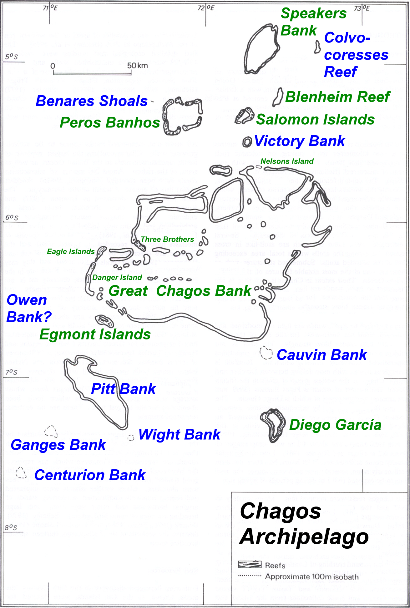
The Chagos Archipelago () or Chagos Islands (formerly the Bassas de Chagas, and later the Oil Islands) is a group of seven atolls comprising more than 60 islands in the Indian Ocean about 500 kilometres (310 mi) south of the Maldives archipelago. This chain of islands is the southernmost archipelago of the Chagos–Laccadive Ridge, a long submarine mountain range in the Indian Ocean. In its north are the Salomon Islands, Nelson's Island and Peros Banhos; towards its south-west are the Three Brothers, Eagle, Egmont and Danger Island(s); southeast of these is Diego Garcia, by far the largest island. All are low-lying atolls, save for a few extremely small instances, set around lagoons. The Chagos Islands had been home to the native Chagossians, a Bourbonnais Creole-speaking people, until the United Kingdom expelled them from the archipelago at the request of the United States between 1967 and 1973 to allow the United States to build a military base on Diego Garcia. Since 197 ... [...More Info...] [...Related Items...] OR: [Wikipedia] [Google] [Baidu] |
International Court Of Justice
The International Court of Justice (ICJ; french: Cour internationale de justice, links=no; ), sometimes known as the World Court, is one of the six principal organs of the United Nations (UN). It settles disputes between states in accordance with international law and gives advisory opinions on international legal issues. The ICJ is the only international court that adjudicates general disputes between countries, with its rulings and opinions serving as primary sources of international law. The ICJ is the successor of the Permanent Court of International Justice (PCIJ), which was established in 1920 by the League of Nations. After the Second World War, both the league and the PCIJ were replaced by the United Nations and ICJ, respectively. The Statute of the ICJ, which sets forth its purpose and structure, draws heavily from that of its predecessor, whose decisions remain valid. All member states of the UN are party to the ICJ Statute and may initiate contentious cases; ho ... [...More Info...] [...Related Items...] OR: [Wikipedia] [Google] [Baidu] |
Western Australia
Western Australia (commonly abbreviated as WA) is a state of Australia occupying the western percent of the land area of Australia excluding external territories. It is bounded by the Indian Ocean to the north and west, the Southern Ocean to the south, the Northern Territory to the north-east, and South Australia to the south-east. Western Australia is Australia's largest state, with a total land area of . It is the second-largest country subdivision in the world, surpassed only by Russia's Sakha Republic. the state has 2.76 million inhabitants percent of the national total. The vast majority (92 percent) live in the south-west corner; 79 percent of the population lives in the Perth area, leaving the remainder of the state sparsely populated. The first Europeans to visit Western Australia belonged to the Dutch Dirk Hartog expedition, who visited the Western Australian coast in 1616. The first permanent European colony of Western Australia occurred following the ... [...More Info...] [...Related Items...] OR: [Wikipedia] [Google] [Baidu] |
Cape Range National Park
Cape Range National Park is a national park in the Gascoyne region of Western Australia, north of Perth. The park occupies the western side of the North West Cape peninsula over an area of . The nearest town is Exmouth. Directly off the coast is the Ningaloo Reef. The area resulted from a gradual uplifting from the sea floor followed by fluctuating sea levels, wind and water erosion that have slowly eroded the range and plain leaving behind a range of rugged limestone, deep canyons and pristine beaches. Overview The Cape is the only elevated plateau composed of limestone on the North West Coast. The range has plateaus to an elevation of and forms the backbone of the peninsula which extends as far as North West Cape. Yardie Creek, a spectacular gorge where the water is trapped by a sandbar, is located within the park. Over 700 caves are located within the park and it is probable that many others remain undiscovered. Over 630 species of wildflower are found within the park, tha ... [...More Info...] [...Related Items...] OR: [Wikipedia] [Google] [Baidu] |
Australia
Australia, officially the Commonwealth of Australia, is a Sovereign state, sovereign country comprising the mainland of the Australia (continent), Australian continent, the island of Tasmania, and numerous List of islands of Australia, smaller islands. With an area of , Australia is the largest country by area in Oceania and the world's List of countries and dependencies by area, sixth-largest country. Australia is the oldest, flattest, and driest inhabited continent, with the least fertile soils. It is a Megadiverse countries, megadiverse country, and its size gives it a wide variety of landscapes and climates, with Deserts of Australia, deserts in the centre, tropical Forests of Australia, rainforests in the north-east, and List of mountains in Australia, mountain ranges in the south-east. The ancestors of Aboriginal Australians began arriving from south east Asia approximately Early human migrations#Nearby Oceania, 65,000 years ago, during the Last Glacial Period, last i ... [...More Info...] [...Related Items...] OR: [Wikipedia] [Google] [Baidu] |
Kanyakumari
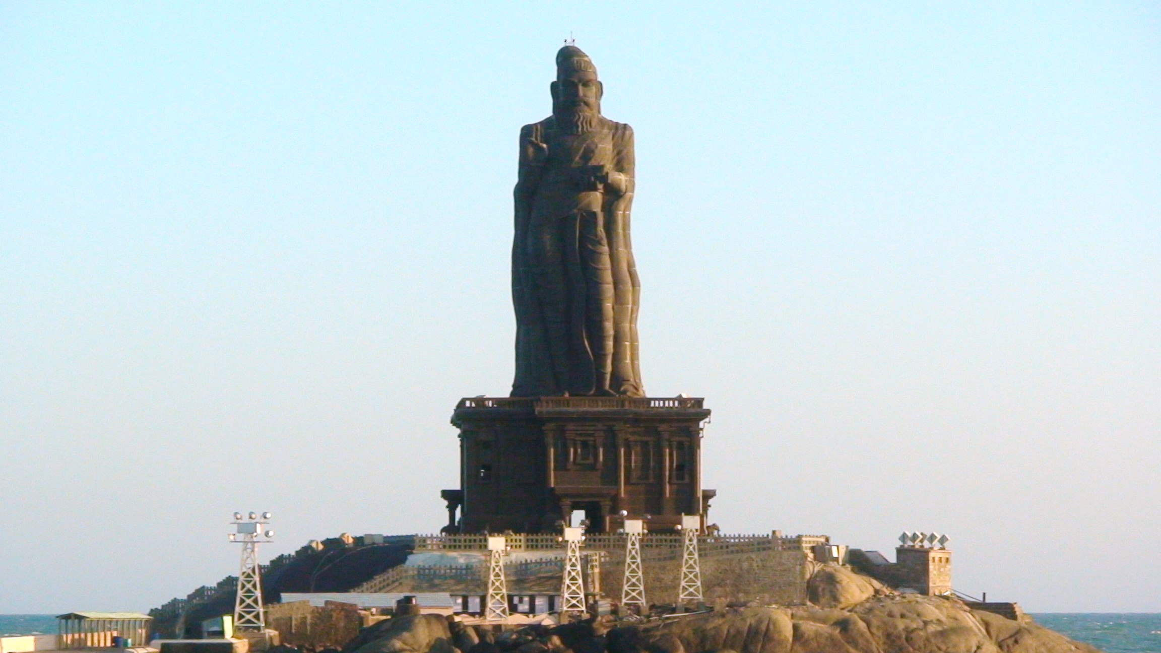
Kanniyakumari (; , referring to Devi Kanya Kumari), also known as Cape Comorin, is a city in Kanniyakumari district in the state of Tamil Nadu, India. It is the southern tip of the Indian subcontinent and the southernmost city in mainland India, thus referred to as 'The Land's End'. The city is situated south of Thiruvananthapuram city, and about south of Nagercoil, the headquarters of Kanniyakumari district. Kanniyakumari is a popular tourist destination and pilgrimage centre in India. Notable tourist spots include its unique sunrise and sunset points, the Thiruvalluvar Statue and Vivekananda Rock Memorial off the coast. Lying at the tip of peninsular India, the town is bordered on the west, south and east by the Laccadive Sea. It has a coastal line of stretched on the three sides. On the shores of the city is a temple dedicated to Goddess Kanniyakumari (the virgin Goddess), after which the town is named.https://thehinduimages.com/details-page.php?id=157918128 ... [...More Info...] [...Related Items...] OR: [Wikipedia] [Google] [Baidu] |
India
India, officially the Republic of India (Hindi: ), is a country in South Asia. It is the seventh-largest country by area, the second-most populous country, and the most populous democracy in the world. Bounded by the Indian Ocean on the south, the Arabian Sea on the southwest, and the Bay of Bengal on the southeast, it shares land borders with Pakistan to the west; China, Nepal, and Bhutan to the north; and Bangladesh and Myanmar to the east. In the Indian Ocean, India is in the vicinity of Sri Lanka and the Maldives; its Andaman and Nicobar Islands share a maritime border with Thailand, Myanmar, and Indonesia. Modern humans arrived on the Indian subcontinent from Africa no later than 55,000 years ago., "Y-Chromosome and Mt-DNA data support the colonization of South Asia by modern humans originating in Africa. ... Coalescence dates for most non-European populations average to between 73–55 ka.", "Modern human beings—''Homo sapiens''—originated in Africa. Then, int ... [...More Info...] [...Related Items...] OR: [Wikipedia] [Google] [Baidu] |
Tanzania
Tanzania (; ), officially the United Republic of Tanzania ( sw, Jamhuri ya Muungano wa Tanzania), is a country in East Africa within the African Great Lakes region. It borders Uganda to the north; Kenya to the northeast; Comoro Islands and the Indian Ocean to the east; Mozambique and Malawi to the south; Zambia to the southwest; and Rwanda, Burundi, and the Democratic Republic of the Congo to the west. Mount Kilimanjaro, Africa's highest mountain, is in northeastern Tanzania. According to the United Nations, Tanzania has a population of million, making it the most populous country located entirely south of the equator. Many important hominid fossils have been found in Tanzania, such as 6-million-year-old Pliocene hominid fossils. The genus Australopithecus ranged across Africa between 4 and 2 million years ago, and the oldest remains of the genus ''Homo'' are found near Lake Olduvai. Following the rise of '' Homo erectus'' 1.8 million years ago, humanity spread ... [...More Info...] [...Related Items...] OR: [Wikipedia] [Google] [Baidu] |
Pacific Ocean
The Pacific Ocean is the largest and deepest of Earth's five oceanic divisions. It extends from the Arctic Ocean in the north to the Southern Ocean (or, depending on definition, to Antarctica) in the south, and is bounded by the continents of Asia and Oceania in the west and the Americas in the east. At in area (as defined with a southern Antarctic border), this largest division of the World Ocean—and, in turn, the hydrosphere—covers about 46% of Earth's water surface and about 32% of its total surface area, larger than Earth's entire land area combined .Pacific Ocean . '' Britannica Concise.'' 2008: Encyclopædia Britannica, Inc. The centers of both the |
Guam
Guam (; ch, Guåhan ) is an organized, unincorporated territory of the United States in the Micronesia subregion of the western Pacific Ocean. It is the westernmost point and territory of the United States (reckoned from the geographic center of the U.S.); its capital Hagåtña (144°45'00"E) lies further west than Melbourne, Australia (144°57'47"E). In Oceania, Guam is the largest and southernmost of the Mariana Islands and the largest island in Micronesia. Guam's capital is Hagåtña, and the most populous village is Dededo. People born on Guam are American citizens but have no vote in the United States presidential elections while residing on Guam and Guam delegates to the United States House of Representatives have no vote on the floor. Indigenous Guamanians are the Chamoru, historically known as the Chamorro, who are related to the Austronesian peoples of Indonesia, the Philippines, Malaysia, Taiwan, Micronesia, and Polynesia. As of 2022, Guam's population is 168, ... [...More Info...] [...Related Items...] OR: [Wikipedia] [Google] [Baidu] |
Andersen Air Force Base
Andersen Air Force Base (Andersen AFB, AAFB) is a United States Air Force base located primarily within the village of Yigo in the United States territory of Guam. The host unit at Andersen AFB is the 36th Wing (36 WG), assigned to the Pacific Air Forces Eleventh Air Force. As a non-flying wing, the 36 WG's mission is to provide support to deployed air and space forces of USAF, foreign air forces to Andersen, and tenant units assigned to the base. Andersen AFB was placed under the installation management authority of Joint Region Marianas on 1 October 2009, along with Naval Base Guam. The two bases are about apart at opposite ends of the island. Established in 1944 after the Liberation of Guam as North Field, it is named for Brigadier General James Roy Andersen (1904–1945). The most important U.S. air base west of Hawaii, Andersen is one of the four Air Force Bomber Forward Operating Locations and the only base in the Western Pacific that can permanently service U.S. heavy ... [...More Info...] [...Related Items...] OR: [Wikipedia] [Google] [Baidu] |


.jpg)


.jpg)
