|
Barandal
Barandal (officially, Barangay Barandal) is an industrial barangay of the city of Calamba in the province of Laguna, Philippines. It is geographically situated in the middle of the city. It houses various residential areas like Amaia Scapes by Ayala Land, Vista Hills by Filinvest Land, Calamba Hills Village Phase 2 by TESCO, Crescent Knoll by Major Homes, Laguna Buenavista Executive Homes by TESCO, Carmel Village Phase 2, Chateau Milano by TESCO, Andrea Paz Subdivision, and GK-Philipps Pabahay. The barangay is also the location of several companies in the Calamba Premier Industrial Park (CPIP). Geography Neighboring barangays: *West - Palo-Alto and Punta *East - Batino and Prinza *South - Turbina *North - Mayapa Mayapa is an urban barangay, located to the east of the Sirang Lupa and southeast of the Canlubang in Calamba City, Laguna, Philippines. It is next to the Mayapa-Canlubang exit (Exit 47) of the South Luzon Expressway. As of the 2020 census, ... Sitios and purok ... [...More Info...] [...Related Items...] OR: [Wikipedia] [Google] [Baidu] |
Batino
Batino is a rural industrial barangay located at Calamba City, Laguna, Philippines. Batino is located to the east of Barandal, south of Mayapa, north of Prinza and west of Paciano Rizal. Most of the establishments, if not all, are located on the west side of South Luzon Expressway (SLEX), leaving the east side of the barangay less developed than the west side of it, partly because the only access points are the SLEX and the Batino-Mayapa Road. Etymology Barangay Batino got its name from the hard milkwood tree or '' Alstonia microphylla'', which is called ''batino'' in Tagalog. The tree was once abundant in the area. Calamba Premiere International Park In this barangay, numerous companies like Avon, Samsung The Samsung Group (or simply Samsung) ( ko, 삼성 ) is a South Korean multinational manufacturing conglomerate headquartered in Samsung Town, Seoul, South Korea. It comprises numerous affiliated businesses, most of them united under the ..., Shin Heung Electro ... [...More Info...] [...Related Items...] OR: [Wikipedia] [Google] [Baidu] |
Calamba City
Calamba, officially the City of Calamba ( fil, Lungsod ng Calamba), is a 1st class component city in the province of Laguna, Philippines. According to the 2020 census, it has a population of 539,671 people. Calamba is the regional center of the Calabarzon region. It is situated south of Manila and west of Santa Cruz. The city is known as the "Spring Resort Capital of the Philippines" because of its numerous hot spring resorts, which are mostly located in Barangays Pansol, Bucal, Bagong Kalsada, and Lingga. According to the 2020 census, Calamba has a population of 539,671 people, making it the most populous local government unit in Laguna. It is the fifth-densest city in the province with more than 2,600 people per square kilometer after San Pedro, Biñan, Cabuyao, and Santa Rosa. Based on the overall rankings of the 2014 Cities and Municipalities Index, the city ranked 18th in the overall competitiveness (cities ranking) and first among cities in the Calabarzon region. Cal ... [...More Info...] [...Related Items...] OR: [Wikipedia] [Google] [Baidu] |
Calamba, Laguna
Calamba, officially the City of Calamba ( fil, Lungsod ng Calamba), is a 1st class Cities of the Philippines#Legal classification, component city in the Provinces of the Philippines, province of Laguna (province), Laguna, Philippines. According to the 2020 census, it has a population of 539,671 people. Calamba is the regional center of the Calabarzon region. It is situated south of Manila and west of Santa Cruz, Laguna, Santa Cruz. The city is known as the "Spring Resort Capital of the Philippines" because of its numerous hot spring resorts, which are mostly located in Barangays Pansol, Bucal, Bagong Kalsada, and Lingga. According to the 2020 census, Calamba has a population of 539,671 people, making it the most populous local government unit in Laguna. It is the fifth-densest city in the province with more than 2,600 people per square kilometer after San Pedro, Laguna, San Pedro, Biñan, Cabuyao, and Santa Rosa, Laguna, Santa Rosa. Based on the overall rankings of the 2014 Ci ... [...More Info...] [...Related Items...] OR: [Wikipedia] [Google] [Baidu] |
Calamba Premiere International Park
The Calamba Premiere International Park (CPIP), established in 1999, is one of the first industrial parks in the Philippines. It is a comprehensively-planned industrial estate located at Batino, Barandal, and Prinza in Calamba, Laguna and provides a workplace for technology-based, light and medium industries. Industrial Park Locators One of the most important of the industrial parks in the Philippines, with four in this region of Calabarzon in Laguna: Calamba Premiere International Park or CPIP (formerly known as Calamba Premiere Industrial Park), Carmelray Industrial Park 1 in Canlubang, Carmelray Industrial Park 2 in Punta, and Light Industry and Science Park of the Philippines II in Real Real may refer to: Currencies * Brazilian real (R$) * Central American Republic real * Mexican real * Portuguese real * Spanish real * Spanish colonial real Music Albums * ''Real'' (L'Arc-en-Ciel album) (2000) * ''Real'' (Bright album) (2010) .... Locators See also * Ligh ... [...More Info...] [...Related Items...] OR: [Wikipedia] [Google] [Baidu] |
Punta, Calamba
Punta is a rural barangay of Calamba City, Laguna in the Philippines. It is situated in the central-south portion of the city. Geography Barangay Punta is located in the western part of Calamba City. The barangay is bordered by: Kay-Anlog in the south; Bubuyan in the west; Milagrosa in the east, Palo-Alto in the north-west and Barandal in the north. It has total land area of 331 hectares. Punta is now an industrial barangay in Calamba City and its extends in barangay Prinza. The Filinvest Technology Park in Ciudad de Calamba Barangay Punta is under PEZA Philippine Economic Zone Authority Philippine Economic Zone Authority (PEZA) is a government agency in the Philippines attached to the Department of Trade and Industry created to help promote investments in the export-oriented manufacturing industry into the country by assisting ... . Some of the manufacturing company inside the economic zone is the EXELPACK CORPORATION a packaging company own by a Filipino businessman, ... [...More Info...] [...Related Items...] OR: [Wikipedia] [Google] [Baidu] |
Palo-Alto
Palo-Alto is a barangay in Calamba, Laguna in the Philippines. It is located south of Mayapa, west of Barandal, south-east of Majada Out, and northeast of Laguerta. Sitios and Puroks * Highland One * Highland Two * Kasikuhan * Manggahan * Palo-Alto Subdivisions * Bay Hill * Hacienda Hill * Maresco * Oak Hill * Pacific Hill * Palm Hill * Phirst Park Homes * Saint Francisco Heights * Southwynds Residences * Highlands 1 * Highlands 2 * Camella - Lessandra Education * Palo Alto Care Center * Palo Alto Elementary School * Palo Alto Integrated School * Golden Wisdom School of Calamba Inc. * Holy Redeemer School of Calamba, Laguna Inc. * Twin Stars School of Calamba Inc. Demography *2015 - 15,208 *2014 – 12,362 *2013 – 11,903 *2012 – 11,462 *2011 – 11,037 *2010 – 10,628 *2007 – 7,270 *2000 – 2,881 *1995 – 2,312 *1990 – 1,913 *1980 – 1,472 References External links Official Website of the Provincial Government of Laguna Barangays of Calamba, L ... [...More Info...] [...Related Items...] OR: [Wikipedia] [Google] [Baidu] |
Mayapa
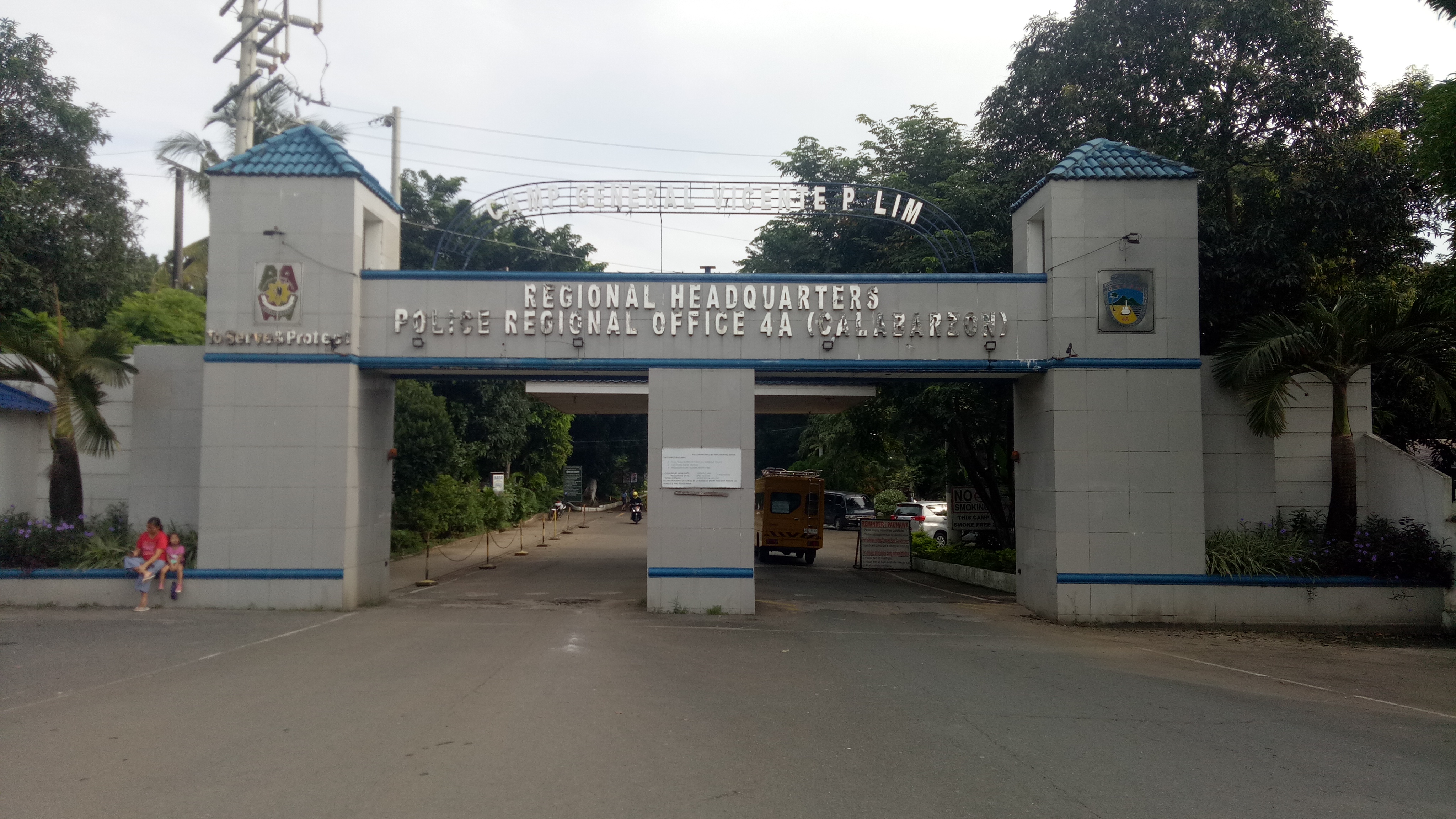
Mayapa is an urban barangay, located to the east of the Sirang Lupa and southeast of the Canlubang in Calamba City, Laguna, Philippines. It is next to the Mayapa-Canlubang exit (Exit 47) of the South Luzon Expressway. As of the 2020 census, Mayapa had a population of 28,302. Camp Vicente Lim Camp Vicente Lim is Located along National Highway Mayapa Road, and also the Headquarters of PRO CALABARZON Headquarters (Region IV-A), it's also known as Calamba Airstrip or Calamba Airfield since 1922. There are primary and secondary school building inside the camp. Camp Vicente Lim Elementary School also known as Post Elementary School, and Camp Vicente Lim National High School. There's also residential area known as Campo by the locals or Bargy., Camp Vicente Lim. The means of transportation inside the Camp premises or inside Brgy., Camp Vicente Lim is by pedicab. The Regional Headquarters also the main Headquarters of Bureau of Fire also inside the Camp Vicente Lim. The National Forens ... [...More Info...] [...Related Items...] OR: [Wikipedia] [Google] [Baidu] |
Turbina, Calamba
Turbina is an urban barangay of Calamba City in Laguna. It is geographically situated in the south of the city. Turbina is known for the barangay terminal station of Calamba, located at the Maharlika Highway, which is accessible by South Luzon Expressway The South Luzon Expressway (SLEX), signed as E2 of the Philippine expressway network and R-3 of the Metro Manila arterial road network, is a limited-access toll expressway that connects Metro Manila to the provinces in the Calabarzon region ...'s Calamba Exit. Neighboring barangays Population References External linksOfficial Website of the Government of Laguna Barangays of Calamba, Laguna {{Calabarzon-geo-stub ... [...More Info...] [...Related Items...] OR: [Wikipedia] [Google] [Baidu] |
Cities Of The Philippines
A city ( fil, lungsod/siyudad) is one of the units of local government in the Philippines. All Philippine cities are chartered cities ( fil, nakakartang lungsod), whose existence as corporate and administrative entities is governed by their own specific municipal charters in addition to the Local Government Code of 1991, which specifies their administrative structure and powers. As of December 17, 2022, there are 148 cities. A city is entitled to at least one representative in the House of Representatives if its population reaches 250,000. Cities are allowed to use a common seal. As corporate entities, cities have the power to take, purchase, receive, hold, lease, convey, and dispose of real and personal property for its general interests, condemn private property for public use (eminent domain), contract and be contracted with, sue and exercise all the powers conferred to it by Congress. Only an Act of Congress can create or amend a city charter, and with this city charter Cong ... [...More Info...] [...Related Items...] OR: [Wikipedia] [Google] [Baidu] |
Calabarzon
Calabarzon (), formally known as the Southern Tagalog Mainland, is an administrative region in the Philippines, designated as Region IV-A. The region comprises five provinces: Batangas, Cavite, Laguna, Quezon, and Rizal; and one highly urbanized city, Lucena. The region is the most populous region in the Philippines according to the Philippine Statistics Authority, having over 14.4 million inhabitants in 2020, and is also the country's second most densely populated after the National Capital Region. The region is situated southeast of Metro Manila, and is bordered by the Manila Bay to the west, Lamon Bay and the Bicol Region to the east, the Tayabas Bay and Sibuyan Sea to the south, and Central Luzon to the north. It is home to places like Mount Makiling near Los Baños, Laguna, and the Taal Volcano in Batangas. Prior to its creation as a region, Calabarzon, together with the Mimaropa region, the province of Aurora and several parts of Metro Manila, formed the historical ... [...More Info...] [...Related Items...] OR: [Wikipedia] [Google] [Baidu] |
Purok
A ''purok'' ( en, district or zone) is a division within a barangay in the Philippines. While not officially considered a local government unit (LGU), a purok often serves as a unit for delivering services and administration within a barangay. A ''purok'' is typically composed of twenty to fifty or more households, depending on the particular geographical location and cluster of houses. The term purok is often applied to a neighborhood (zone) within an urbanized barangay, or a portion (district) of a less densely populated, but still relatively geographically compact, barangay. This contrasts with the ''sitio'', which is usually a cluster of households (hamlet) in a more dispersed, rural barangay. If created and given a mandate by an ordinance of the barangay, municipality, or city, a purok could perform government functions under the coordination and supervision of their local officials. Sometimes, a member of the Sangguniang Barangay (Barangay Council) may be recognized as ... [...More Info...] [...Related Items...] OR: [Wikipedia] [Google] [Baidu] |
Barangay
A barangay (; abbreviated as Brgy. or Bgy.), historically referred to as barrio (abbreviated as Bo.), is the smallest administrative division in the Philippines and is the native Filipino term for a village, district, or ward. In metropolitan areas, the term often refers to an inner city neighborhood, a suburb, or a suburban neighborhood or even a borough. The word ''barangay'' originated from ''balangay'', a type of boat used by a group of Austronesian peoples when they migrated to the Philippines. Municipalities and cities in the Philippines are politically subdivided into barangays, with the exception of the municipalities of Adams in Ilocos Norte and Kalayaan in Palawan, with each containing a single barangay. Barangays are sometimes informally subdivided into smaller areas called ''purok'' ( en, "wikt:zone, zone"), or barangay zones consisting of a cluster of houses for organizational purposes, and ''sitios'', which are territorial enclaves—usually rural—far from t ... [...More Info...] [...Related Items...] OR: [Wikipedia] [Google] [Baidu] |


