|
Anglo-Dutch Treaty Of 1824
The Anglo-Dutch Treaty of 1824, also known as the Treaty of London, was a treaty signed between the United Kingdom and the Netherlands in London on 17 March 1824. The treaty was to resolve disputes arising from the execution of the Anglo-Dutch Treaty of 1814. For the Dutch, it was signed by Hendrik Fagel and Anton Reinhard Falck, and for the British, George Canning and Charles Williams-Wynn.H.R.C. Wright, "The Anglo-Dutch Dispute in the East, 1814-1824." ''Economic History Review'' 3.2 (1950): 229-23online History The Anglo-Dutch Treaty of 1824, designed to solve many of the issues that had arisen by the British occupation of Dutch colonial possessions during the Napoleonic Wars as well as those regarding the rights to trade that existed for hundreds of years in the Spice Islands between the two nations, was a treaty that addressed a wide array of issues and did not clearly describe the limitations of expansion by either side in the Malay world. The British establishmen ... [...More Info...] [...Related Items...] OR: [Wikipedia] [Google] [Baidu] |
Bilateral Treaty
A bilateral treaty (also called a bipartite treaty) is a treaty strictly between two state entities. It is an agreement made by negotiations between two parties, established in writing and signed by representatives of the parties. Treaties can span in substance and complexity, regarding a wide variety of matters, such as territorial boundaries, trade and commerce, political alliances, and more. The agreement is usually then ratified by the lawmaking authority of each party or organization. Any agreement with more than two parties is a multilateral treaty. Similar to a contract, it is also called a contractual treaty. As with any other treaty, it is a written agreement that is typically formal and binding in nature. Involved Parties These two parties can be two nations, or two international organizations, or one nation and one international organization, or two persons. It is possible for a bilateral treaty to involve more than two parties; for example, each of the bilateral tre ... [...More Info...] [...Related Items...] OR: [Wikipedia] [Google] [Baidu] |
Piracy
Piracy is an act of robbery or criminal violence by ship or boat-borne attackers upon another ship or a coastal area, typically with the goal of stealing cargo and other valuable goods. Those who conduct acts of piracy are called pirates, vessels used for piracy are pirate ships. The earliest documented instances of piracy were in the 14th century BC, when the Sea Peoples, a group of ocean raiders, attacked the ships of the Aegean and Mediterranean civilisations. Narrow channels which funnel shipping into predictable routes have long created opportunities for piracy, as well as for privateering and commerce raiding. Historic examples include the waters of Gibraltar, the Strait of Malacca, Madagascar, the Gulf of Aden, and the English Channel, whose geographic structures facilitated pirate attacks. The term ''piracy'' generally refers to maritime piracy, although the term has been generalized to refer to acts committed on land, in the air, on computer networks, and (in scie ... [...More Info...] [...Related Items...] OR: [Wikipedia] [Google] [Baidu] |
Batam
Batam is the largest city in the province of Riau Islands, Indonesia. The city administrative area covers three main islands of Batam, Rempang, and Galang (collectively called Barelang), as well as several small islands. Batam Island is the core urban and industrial zone, while both Rempang Island and Galang Island maintain their rural character and are connected to Batam Island by short bridges. Batam is an industrial boomtown, an emerging transport hub, and part of a free trade zone in the Indonesia–Malaysia–Singapore Growth Triangle, located off Singapore's south coast and also part of the Indonesia–Malaysia–Thailand Growth Triangle. According to Statistics Indonesia's 2020 census, Batam had a population of 1,196,396, making it the third largest city in the region of Sumatra, after Medan and Palembang. It is the closest part of Indonesia to Singapore, at a minimum land distance of 5.8 km. During the 2010 national census, Batam was the fastest-growing mun ... [...More Info...] [...Related Items...] OR: [Wikipedia] [Google] [Baidu] |
Karimun Regency
The Karimun Regency is located in the Riau Islands Province, Indonesia. Besides the central island of Great Karimun, the regency also includes the islands of Kundur and over 240 smaller islands. The district covers a land area of 1,524 km2 and a sea area of 6,460 km2, and its population was 212,561 at the 2010 Census and 253,457 at the 2020 Census. Administrative Districts As at 2010, the Regency was divided into nine districts (''kecamatan''), but subsequently on 11 June 2012 a further three districts have been added - Ungar (from part of Kundur district), Belat (from part of Kundur Utara district), and Meral Barat (out of the western part of Meral). The twelve districts are tabulated below with their areas and populations at the 2010 Census and 2020 Census.Badan Pusat Statistik, Jakarta, 2021. The table also includes the locations of the district administrative centres, the number of administrative villages (rural ''desa'' and urban ''kelurahan'') and the number of i ... [...More Info...] [...Related Items...] OR: [Wikipedia] [Google] [Baidu] |
Belitung
Belitung ( Belitung Malay: ''Belitong'', formerly Billiton) is an island on the east coast of Sumatra, Indonesia in the Java Sea. It covers , and had a population of 309,097 at the 2020 Census. Administratively, it forms two regencies ( Belitung Regency and East Belitung Regency) within the province of Bangka-Belitung Islands. The island is known for its pepper and for its tin. It was in the possession of the United Kingdom from 1812 until Britain ceded control of the island to the Netherlands in the Anglo-Dutch Treaty of 1824. Its main town is Tanjung Pandan. The United Nations Educational, Scientific and Cultural Organization has declared 17 tourist attractions in the Belitung Geopark as world geoparks. Demography The population was 262,357 at the 2010 Census and 309,097 at the 2020 Census. The population is centred in several small towns; the largest are Tanjung Pandan in the west and Manggar in the east, which are the respective capitals of the two Regencies (Belitung ... [...More Info...] [...Related Items...] OR: [Wikipedia] [Google] [Baidu] |
Malay Peninsula
The Malay Peninsula ( Malay: ''Semenanjung Tanah Melayu'') is a peninsula in Mainland Southeast Asia. The landmass runs approximately north–south, and at its terminus, it is the southernmost point of the Asian continental mainland. The area contains Peninsular Malaysia, Southern Thailand, and the southernmost tip of Myanmar (Kawthaung). The island country of Singapore also has historical and cultural ties with the region. The indigenous people of the peninsula are the Malays, an Austronesian people. The Titiwangsa Mountains are part of the Tenasserim Hills system and form the backbone of the peninsula and the southernmost section of the central cordillera, which runs from Tibet through the Kra Isthmus, the peninsula's narrowest point, into the Malay Peninsula. The Strait of Malacca separates the Malay Peninsula from the Indonesian island of Sumatra, and the south coast is separated from the island of Singapore by the Straits of Johor. Etymology The Malay term ' ... [...More Info...] [...Related Items...] OR: [Wikipedia] [Google] [Baidu] |
Malacca
Malacca ( ms, Melaka) is a States and federal territories of Malaysia, state in Malaysia located in the southern region of the Malay Peninsula, next to the Strait of Malacca. Its capital is Malacca City, dubbed the Historic City, which has been listed as a UNESCO World Heritage Site since 7 July List of World Heritage Sites by year of inscription#2008 (32nd session), 2008. The state is bordered by Negeri Sembilan to the north and west and Johor to the south. The Enclaves and exclaves, exclave of Tanjung Tuan also borders Negeri Sembilan to the north. Its capital Malacca City is southeast of Malaysia's capital city Kuala Lumpur, northwest of Johor's largest city Johor Bahru and northwest of Johor's second largest city, Batu Pahat (city), Batu Pahat. Although it was the location of one of the earliest Malay sultanates, namely the Malacca Sultanate, the local monarchy was abolished when the Portuguese conquered it in 1511. The head of state is the ''Yang di-Pertua Negeri'' or ... [...More Info...] [...Related Items...] OR: [Wikipedia] [Google] [Baidu] |
Sumatra
Sumatra is one of the Sunda Islands of western Indonesia. It is the largest island that is fully within Indonesian territory, as well as the sixth-largest island in the world at 473,481 km2 (182,812 mi.2), not including adjacent islands such as the Simeulue, Nias, Mentawai, Enggano, Riau Islands, Bangka Belitung and Krakatoa archipelago. Sumatra is an elongated landmass spanning a diagonal northwest–southeast axis. The Indian Ocean borders the northwest, west, and southwest coasts of Sumatra, with the island chain of Simeulue, Nias, Mentawai, and Enggano off the western coast. In the northeast, the narrow Strait of Malacca separates the island from the Malay Peninsula, which is an extension of the Eurasian continent. In the southeast, the narrow Sunda Strait, containing the Krakatoa Archipelago, separates Sumatra from Java. The northern tip of Sumatra is near the Andaman Islands, while off the southeastern coast lie the islands of Bangka and Belitung, ... [...More Info...] [...Related Items...] OR: [Wikipedia] [Google] [Baidu] |
Bencoolen Presidency
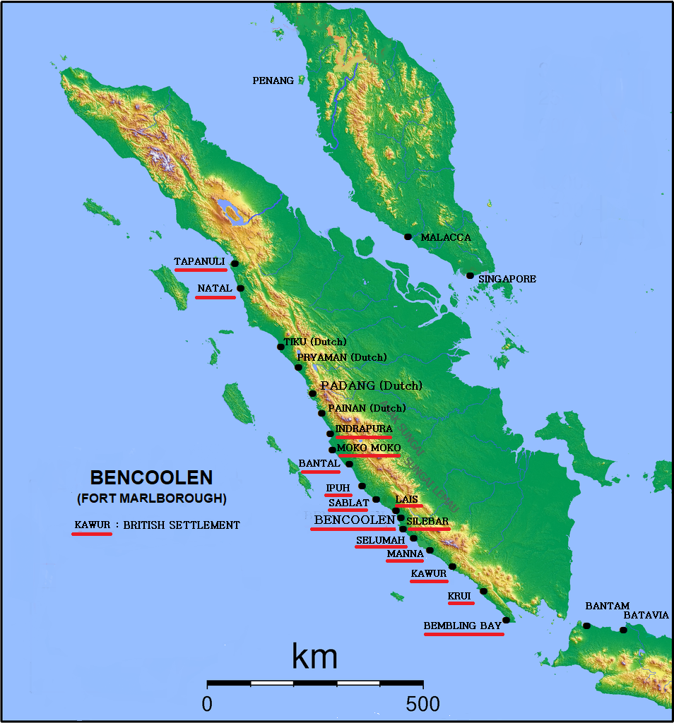
British Bencoolen was a possession of the British East India Company (EIC) extending about 300 miles along the southwestern coast of Sumatra and centered on the area of what is now Bengkulu City. The EIC established a presence there in 1685, and in 1714 the EIC built Fort Marlborough there. A local datoo allowed EIC to build the fort in order to protect the settlement from the Dutch. Establishment and early development ''It was a fatall and never enough to be repented errour of our President and Council of Fort St. George adrasto break all our orders for a settlement at Pryaman upon a caprice of their owne to send our ships, spend our strength, our money and soe many men's lives upon settlement at such an unhealthful place as Bencoolen, because they hear there was more pepper there.'' In 1683, following the forcible closing of their factory at Bantam in Java and under the likelihood of being turned out at any moment from Dutch-ruled Malacca, the Directors of the East India ... [...More Info...] [...Related Items...] OR: [Wikipedia] [Google] [Baidu] |
Dutch India
Dutch India consisted of the settlements and trading posts of the Dutch East India Company on the Indian subcontinent. It is only used as a geographical definition, as there was never a political authority ruling all Dutch India. Instead, Dutch India was divided into the governorates Dutch Ceylon and Dutch Coromandel, the commandment Dutch Malabar, and the directorates Dutch Bengal and Dutch Suratte. The Dutch Indies, on the other hand, were the Dutch East Indies (present-day Indonesia) and the Dutch West Indies (present-day Suriname and the former Netherlands Antilles). History Dutch presence on the Indian subcontinent lasted from 1605 to 1825. Merchants of the Dutch East India Company first established themselves in Dutch Coromandel, notably Pulicat, as they were looking for textiles to exchange with the spices they traded in the East Indies. Dutch Suratte and Dutch Bengal were established in 1616 and 1627 respectively. After the Dutch conquered Ceylon from the Port ... [...More Info...] [...Related Items...] OR: [Wikipedia] [Google] [Baidu] |
Indian Subcontinent
The Indian subcontinent is a list of the physiographic regions of the world, physiographical region in United Nations geoscheme for Asia#Southern Asia, Southern Asia. It is situated on the Indian Plate, projecting southwards into the Indian Ocean from the Himalayas. Geopolitically, it includes the countries of Bangladesh, Bhutan, India, Maldives, Nepal, Pakistan, and Sri Lanka."Indian subcontinent". ''Oxford Dictionary of English, New Oxford Dictionary of English'' () New York: Oxford University Press, 2001; p. 929: "the part of Asia south of the Himalayas which forms a peninsula extending into the Indian Ocean, between the Arabian Sea and the Bay of Bengal. Historically forming the whole territory of Greater India, the region is now divided into three countries named Bangladesh, India and Pakistan." The terms ''Indian subcontinent'' and ''South Asia'' are often used interchangeably to denote the region, although the geopolitical term of South Asia frequently includes Afghanist ... [...More Info...] [...Related Items...] OR: [Wikipedia] [Google] [Baidu] |
Ternate
Ternate is a city in the Indonesian province of North Maluku and an island in the Maluku Islands. It was the ''de facto'' provincial capital of North Maluku before Sofifi on the nearby coast of Halmahera became the capital in 2010. It is off the west coast of Halmahera, and is composed of eight islands: Ternate, the biggest and main island of the city, and Moti, Hiri, Tifure, Mayau, Makka, Mano, and Gurida. In total, the city has a land area of 162.17 square kilometres and had a total population of 185,705 according to the 2010 census, and 205,001 according to the 2020 census, with a density of 1,264 people per square kilometre. It is the biggest and most densely populated city in the province, is the economic, cultural, and education center of North Maluku, and acts as a hub to neighbouring regions. It was the capital of the Sultanate of Ternate in the 15th and 16th centuries, and fought against the Sultanate of Tidore over control of the spice trade in the Moluccas before bec ... [...More Info...] [...Related Items...] OR: [Wikipedia] [Google] [Baidu] |


