Walnut Street (Philadelphia) on:
[Wikipedia]
[Google]
[Amazon]
 Walnut Street is located in downtown
 It is most known for
  The
The  The street goes westward through Walnut Hill, Dunlap and eventually
 Walnut Street is located in downtown
 Philadelphia
Philadelphia, often called Philly, is the largest city in the Commonwealth of Pennsylvania, the sixth-largest city in the U.S., the second-largest city in both the Northeast megalopolis and Mid-Atlantic regions after New York City. Sinc ...
and extends from the city's Delaware River
The Delaware River is a major river in the Mid-Atlantic (United States), Mid-Atlantic region of the United States. From the meeting of its branches in Hancock (village), New York, Hancock, New York, the river flows for along the borders of N ...
waterfront through Center City and West Philadelphia
West Philadelphia, nicknamed West Philly, is a section of the city of Philadelphia. Alhough there are no officially defined boundaries, it is generally considered to reach from the western shore of the Schuylkill River, to City Avenue to the nort ...
. Walnut Street has been characterized as "the city's premier shopping district". A portion of the street commonly called Rittenhouse Row was ranked 12th in 2005 by ''Women's Wear Daily
''Women's Wear Daily'' (also known as ''WWD'') is a fashion-industry trade journal often referred to as the "Bible of fashion". Horyn, Cathy"Breaking Fashion News With a Provocative Edge" ''The New York Times''. (August 20, 1999). It provides inf ...
'' among its list of the most expensive retail streets in North America
North America is a continent in the Northern Hemisphere and almost entirely within the Western Hemisphere. It is bordered to the north by the Arctic Ocean, to the east by the Atlantic Ocean, to the southeast by South America and the Car ...
, with rents of $90 per square foot, and is home to several "upscale dining, retail and cultural" establishments. In 2013 rents had risen to an average of $107 a foot, a growth of 34% over 2012 and the largest percentage growth of any retail corridor in the country.
Running parallel to Walnut Street, one or two blocks to the north (depending on whether the side street Sansom Street is counted), is Chestnut Street. Pennsylvania Route 3
Pennsylvania Route 3 (PA 3) is a state highway located in the southeastern portion of Pennsylvania. The route runs from U.S. Route 322 Business (US 322 Bus.) in West Chester east to PA 611 in Philadelphia. The route begins in downtown West C ...
westbound follows Walnut Street from 38th Street (U.S. Route 13
U.S. Route 13 (US 13) is a north–south U.S. highway established in 1926 that runs for from Interstate 95 (I-95) just north of Fayetteville, North Carolina to US 1 in the northeastern suburbs of Philadelphia, Pennsylvania, in Morrisville ...
) to its western terminus at the Cobbs Creek Parkway.
Route description
 It is most known for
 Rittenhouse Square
Rittenhouse Square is a neighborhood, including a public park, in Center City Philadelphia. The park is one of the five original open-space parks planned by William Penn and his surveyor Thomas Holme during the late 17th century.
The neighborho ...
Park and its upscale shopping
In economics, a luxury good (or upmarket good) is a good for which demand increases more than what is proportional as income rises, so that expenditures on the good become a greater proportion of overall spending. Luxury goods are in contrast to n ...
district in the high-end neighborhood of the same name. The majority of designer
A designer is a person who plans the form or structure of something before it is made, by preparing drawings or plans.
In practice, anyone who creates tangible or intangible objects, products, processes, laws, games, graphics, services, or exp ...
and fast fashion stores located on Walnut Street are situated on a four-block stretch between Broad Street and 18th Street, which is anchored by the park on the southwest corner. This area of Walnut Street and a few blocks to the east features a variety of shops, eateries, bars, hotels, and office buildings.
 The
The Walnut Street Theatre
The Walnut Street Theatre, founded in 1809 at 825 Walnut Street, on the corner of S. 9th Street in the Washington Square West neighborhood of Philadelphia, is the oldest operating theatre in the United States. The venue is operated by the Walnut ...
, located at 825 Walnut Street, is the oldest continuously-operating theatre in the English-speaking world.
Among the many attractions and historic sites along Walnut Street are Independence National Historical Park
Independence National Historical Park is a federally protected historic district in Philadelphia, Pennsylvania that preserves several sites associated with the American Revolution and the nation's founding history. Administered by the National P ...
and Society Hill
Society Hill is a historic neighborhood in Center City Philadelphia, with a population of 6,215 . Settled in the early 1680s, Society Hill is one of the oldest residential neighborhoods in Philadelphia.The Center City District dates the Free Soc ...
on the east, followed by Washington Square, Washington Square West
Washington Square West is a neighborhood Center City Philadelphia, Pennsylvania. The neighborhood roughly corresponds to the area between 7th and Broad Streets and between Chestnut and South Streets, bordering on the Independence Mall tourist ar ...
, the St. James Hotel (1226-1232), the Philadelphia Stock Exchange
Philadelphia Stock Exchange (PHLX), now known as Nasdaq PHLX, is the first stock exchange established in the United States and the oldest stock exchange in the nation. The exchange is owned by Nasdaq, which acquired it in 2007 for $652 million, a ...
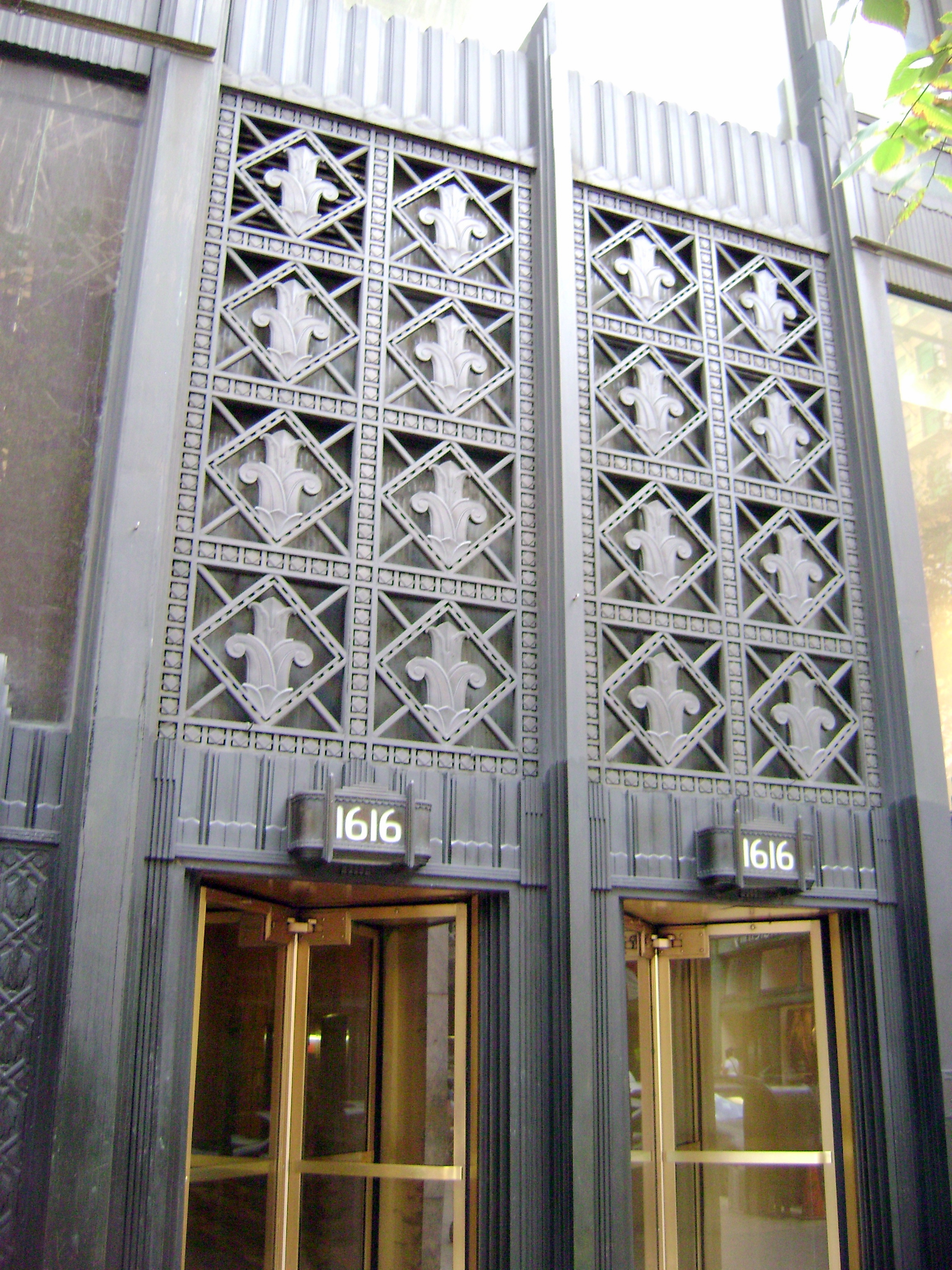
(1419-1411), the Sun Oil Building (1608-1610), the 1616 Walnut Street Building
The 1616 Walnut Street Building or 1616 Building is a historic high-rise building in the Center City area of Philadelphia, Pennsylvania. A twenty-four-story building, it stands ninety-four meters tall.
Listed on the Philadelphia Register of Hist ...
, Rittenhouse Square
Rittenhouse Square is a neighborhood, including a public park, in Center City Philadelphia. The park is one of the five original open-space parks planned by William Penn and his surveyor Thomas Holme during the late 17th century.
The neighborho ...
(also known as Center City West Commercial Historic District), Estey Hall
__NOTOC__
Estey Hall is a historic building on the campus of Shaw University in Raleigh, North Carolina. It was the first building constructed for the higher education of African-American women in the United States. Built in 1873, Estey Hall is th ...
(1701 Walnut Street), and the Church of the Holy Trinity.
The Walnut Street Bridge, completed in 1949, crosses the Schuylkill River
The Schuylkill River ( , ) is a river running northwest to southeast in eastern Pennsylvania. The river was improved by navigations into the Schuylkill Canal, and several of its tributaries drain major parts of Pennsylvania's Coal Region. It fl ...
. On the west side of the river, the street crosses over the Schuylkill Expressway
The Schuylkill Expressway , locally known as "the Schuylkill", is a Controlled-access highway, freeway through southern Montgomery County, Pennsylvania, Montgomery County and the city of Philadelphia in Philadelphia County, Pennsylvania, Philade ...
.
Further west, Walnut Street bisects the campus of the University of Pennsylvania
The University of Pennsylvania (also known as Penn or UPenn) is a private research university in Philadelphia. It is the fourth-oldest institution of higher education in the United States and is ranked among the highest-regarded universitie ...
in the University City section of West Philadelphia
West Philadelphia, nicknamed West Philly, is a section of the city of Philadelphia. Alhough there are no officially defined boundaries, it is generally considered to reach from the western shore of the Schuylkill River, to City Avenue to the nort ...
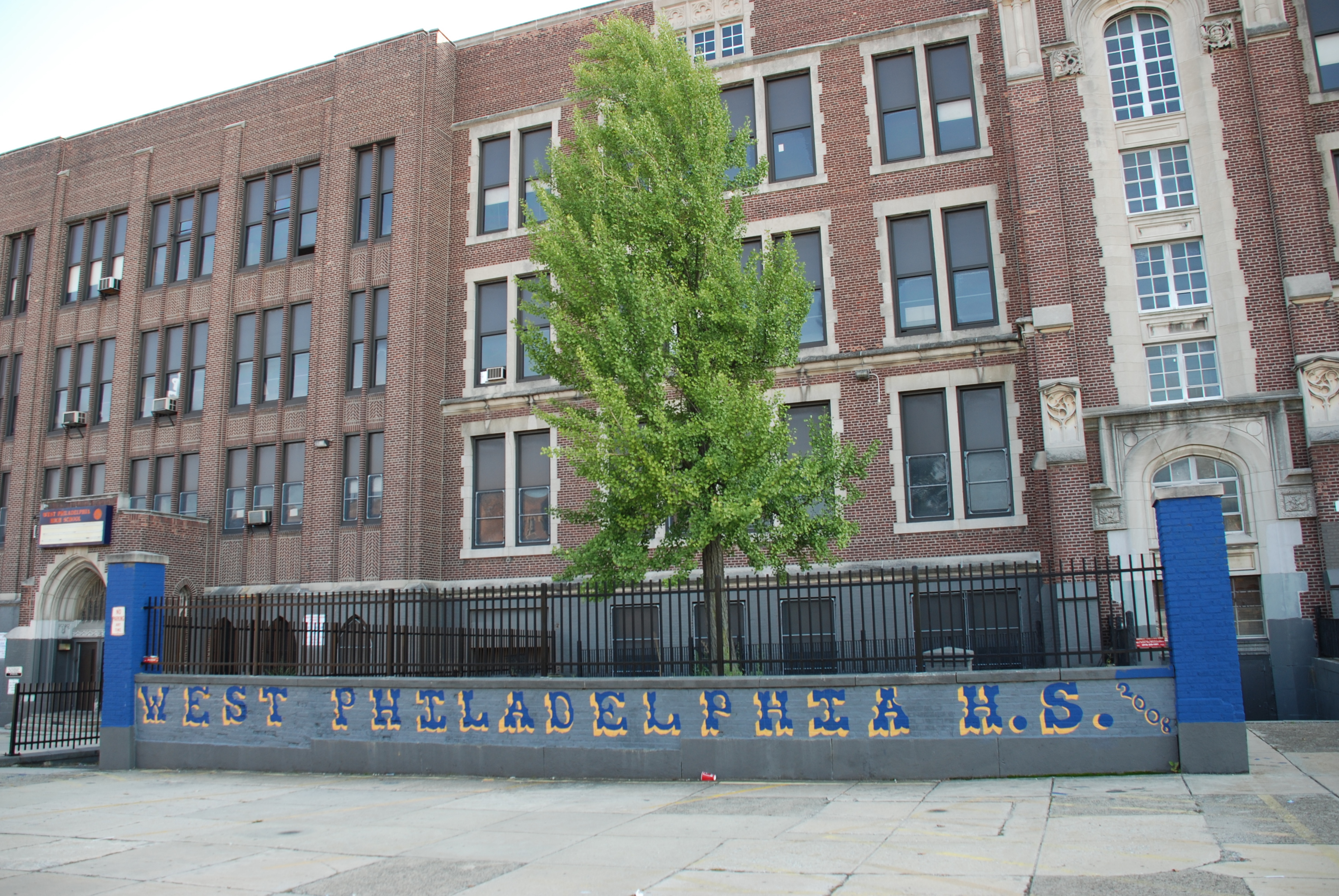
. At 47th Street is the site of the old West Philadelphia High School
West Philadelphia High School is a secondary school located in the West Philadelphia section of Philadelphia, Pennsylvania at the intersection of 49th Street and Chestnut Street.
History
The original West Philadelphia High School (WPHS) building ...
. The Paul Robeson House sits at the corner of 50th and Walnut.
 The street goes westward through Walnut Hill, Dunlap and eventually
 Cobbs Creek
Cobbs Creek is an U.S. Geological Survey. National Hydrography Dataset high-resolution flowline dataThe National Map, accessed April 1, 2011 tributary of Darby Creek in Delaware County, Pennsylvania, in the United States. It forms an approximat ...
where the street ends.
See also
*History of Philadelphia
The city of Philadelphia was founded in 1682 by William Penn in the English Crown Province of Pennsylvania between the Delaware and Schuylkill rivers. Before then, the area was inhabited by the Lenape people. Philadelphia quickly grew into an imp ...
References
{{Coord, 39.951, -75.181, display=title Streets in Philadelphia Shopping districts and streets in the United States