|
Pennsylvania Route 3
Pennsylvania Route 3 (PA 3) is a state highway located in the southeastern portion of Pennsylvania. The route runs from U.S. Route 322 Business (US 322 Bus.) in West Chester east to PA 611 in Philadelphia. The route begins in downtown West Chester and heads east out of the borough as a one-way pair of streets. Between West Chester and Upper Darby, PA 3 follows a four-lane divided highway named West Chester Pike through suburban areas. Along this stretch, the route passes through Edgmont, Newtown Square, Broomall, and Havertown. The route has an interchange with Interstate 476 (I-476) between Broomall and Havertown. Upon reaching Upper Darby, PA 3 heads into Philadelphia along Market Street. In Philadelphia, the route follows multiple one-way pairs, running along Chestnut Street eastbound and Walnut Street westbound in West Philadelphia before heading into Center City Philadelphia along Market Street eastbound and John F. Kennedy Boulevard westbound and ending at Philadelph ... [...More Info...] [...Related Items...] OR: [Wikipedia] [Google] [Baidu] |
Pennsylvania Department Of Transportation
The Pennsylvania Department of Transportation (PennDOT) oversees transportation issues in the Commonwealth of Pennsylvania. The administrator of PennDOT is the Pennsylvania Secretary of Transportation, currently Yassmin Gramian. Presently, PennDOT supports over of state roads and highways, about 25,000 bridges, as well as new roadway construction, the exception being the Pennsylvania Turnpike Commission, although they currently follow PennDOT policies and procedures. In addition, other modes of transportation are supervised or supported by PennDOT. These include aviation, Railroad, rail traffic, mass transit, intrastate highway shipping traffic, motor vehicle safety & licensing, and Driver's license, driver licensing. PennDOT also supports the Ports of Philadelphia, Pittsburgh, and Erie, Pennsylvania, Erie. The current budget is approximately $3.8 billion in federal and state funds. The state budget is supported by the motor vehicle fuels tax which is dedicated solely to ... [...More Info...] [...Related Items...] OR: [Wikipedia] [Google] [Baidu] |
Divided Highway
A dual carriageway ( BE) or divided highway ( AE) is a class of highway with carriageways for traffic travelling in opposite directions separated by a central reservation (BrE) or median (AmE). Roads with two or more carriageways which are designed to higher standards with controlled access are generally classed as motorways, freeways, etc., rather than dual carriageways. A road without a central reservation is a single carriageway regardless of the number of lanes. Dual carriageways have improved road traffic safety over single carriageways and typically have higher speed limits as a result. In some places, express lanes and local/collector lanes are used within a local-express-lane system to provide more capacity and to smooth traffic flows for longer-distance travel. History A very early (perhaps the first) example of a dual carriageway was the ''Via Portuensis'', built in the first century by the Roman emperor Claudius between Rome and its port Ostia at the mouth of t ... [...More Info...] [...Related Items...] OR: [Wikipedia] [Google] [Baidu] |
Southwest Philadelphia
Southwest Philadelphia (formerly Kingsessing Township) is a section of Philadelphia, Pennsylvania, United States. The section can be described as extending from the western side of the Schuylkill River to the city line, with the SEPTA. The northern border is defined by the Philadelphia City Planning Commission as east from the city line along Baltimore Avenue moving south along 51st Street to Springfield Ave. It follows the train tracks until 49th Street. From 49th and Kingsessing Ave the line moves east along Kingsessing Ave. The line then moves south along 46th St to Paschall Ave where it jogs to join Grays Ferry where the line runs to the Schuylkill River. Southwest Philadelphia is also described by the city as being the area south of Baltimore Avenue; at the turn of the 20th century, Baltimore Avenue between 49th and 52nd Streets was known as "The Hub of Southwest Philadelphia" . Historically home to many Irish American neighborhoods, the section now has a large African Amer ... [...More Info...] [...Related Items...] OR: [Wikipedia] [Google] [Baidu] |
Pennsylvania Route 5 (1920s)
The Lakes-to-Sea Highway, also known as the "Ship-to-Shore" highway, was an auto trail in the Northeast U.S., running from Erie, Pennsylvania (on Lake Erie) southeast via Harrisburg and Philadelphia to Atlantic City, New Jersey (on the Atlantic Ocean – the "sea"). The highway roughly followed the following present routes: *U.S. Route 19, Erie to Meadville *U.S. Route 322, Meadville to West Chester *Pennsylvania Route 3, West Chester to Philadelphia *U.S. Route 30, Philadelphia to Atlantic City It ran along the William Penn Highway between Water Street Water Street may refer to: *Water Street, Hong Kong ** Water Street (constituency) around Water Street, Hong Kong * Water Street, Milwaukee *Water Street, Pennsylvania, an unincorporated village * Water Street (Augusta, Maine) *Water Street (St. Jo ... and Hershey. References {{Roadindex Auto trails in the United States Transportation in Atlantic County, New Jersey Transportation in Camden County, New Jersey Transportat ... [...More Info...] [...Related Items...] OR: [Wikipedia] [Google] [Baidu] |
Tram
A tram (called a streetcar or trolley in North America) is a rail vehicle that travels on tramway tracks on public urban streets; some include segments on segregated right-of-way. The tramlines or networks operated as public transport are called tramways or simply trams/streetcars. Many recently built tramways use the contemporary term light rail. The vehicles are called streetcars or trolleys (not to be confused with trolleybus) in North America and trams or tramcars elsewhere. The first two terms are often used interchangeably in the United States, with ''trolley'' being the preferred term in the eastern US and ''streetcar'' in the western US. ''Streetcar'' or ''tramway'' are preferred in Canada. In parts of the United States, internally powered buses made to resemble a streetcar are often referred to as "trolleys". To avoid further confusion with trolley buses, the American Public Transportation Association (APTA) refers to them as "trolley-replica buses". In the Unit ... [...More Info...] [...Related Items...] OR: [Wikipedia] [Google] [Baidu] |
Plank Road
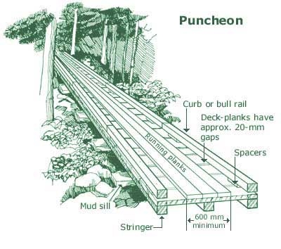
A plank road is a road composed of wooden planks or puncheon logs. Plank roads were commonly found in the Canadian province of Ontario as well as the Northeast and Midwest of the United States in the first half of the 19th century. They were often built by turnpike companies. Origins The Wittmoor bog trackway is the name given to each of two historic plank roads or boardwalks, trackway No. I being discovered in 1898 and trackway No. II in 1904 in the ''Wittmoor'' bog in northern Hamburg, Germany. The trackways date to the 4th and 7th century AD, both linked the eastern and western shores of the formerly inaccessible, swampy bog. A part of the older trackway No. II dating to the period of the Roman Empire is on display at the permanent exhibition of the Archaeological Museum Hamburg in Harburg, Hamburg. This type of plank road is known to have been used as early as 4,000 BC with, for example, the Post Track found in the Somerset levels near Glastonbury, England. This type of ... [...More Info...] [...Related Items...] OR: [Wikipedia] [Google] [Baidu] |
Toll Road
A toll road, also known as a turnpike or tollway, is a public or private road (almost always a controlled-access highway in the present day) for which a fee (or ''toll'') is assessed for passage. It is a form of road pricing typically implemented to help recoup the costs of road construction and maintenance. Toll roads have existed in some form since antiquity, with tolls levied on passing travelers on foot, wagon, or horseback; a practice that continued with the automobile, and many modern tollways charge fees for motor vehicles exclusively. The amount of the toll usually varies by vehicle type, weight, or number of axles, with freight trucks often charged higher rates than cars. Tolls are often collected at toll plazas, toll booths, toll houses, toll stations, toll bars, toll barriers, or toll gates. Some toll collection points are automatic, and the user deposits money in a machine which opens the gate once the correct toll has been paid. To cut costs and minimise time delay, ... [...More Info...] [...Related Items...] OR: [Wikipedia] [Google] [Baidu] |
Philadelphia City Hall
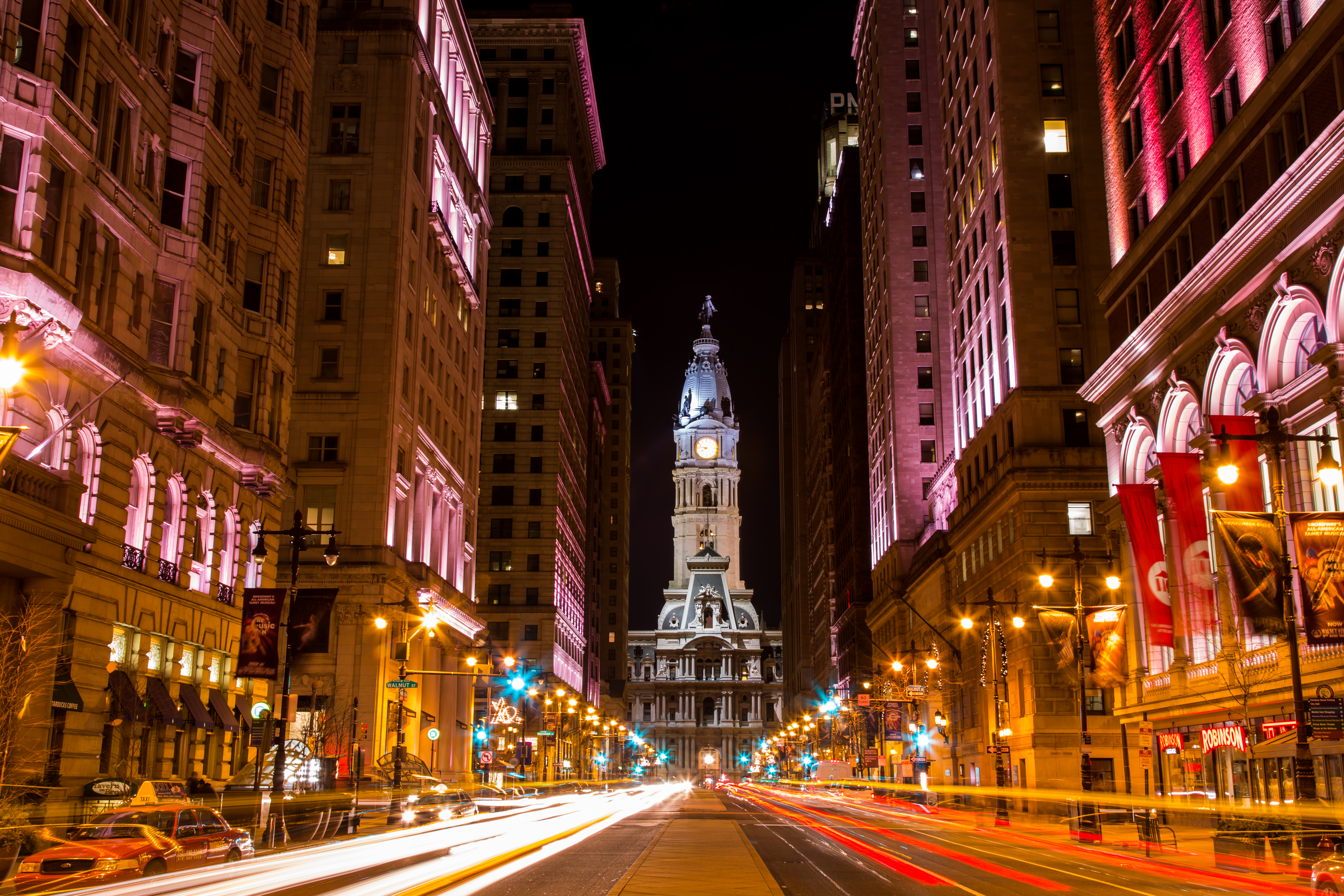
Philadelphia City Hall is the seat of the municipal government of the City of Philadelphia. Built in the ornate Second Empire style, City Hall houses the chambers of the Philadelphia City Council and the offices of the Mayor of Philadelphia. It is also a courthouse, serving as the seat of the First Judicial District of Pennsylvania, and houses the Civil Trial and Orphans' Court Divisions of the Court of Common Pleas of Philadelphia County. Built of brick, white marble, and limestone, Philadelphia City Hall is the world's largest free-standing masonry building and was the world's tallest habitable building upon its completion in 1894. In 1976, it was designated a National Historic Landmark, and in 2006, was also named a National Historic Civil Engineering Landmark by the American Society of Civil Engineers. History and description The building was designed by Scottish-born architect John McArthur Jr. and Thomas Ustick Walter [...More Info...] [...Related Items...] OR: [Wikipedia] [Google] [Baidu] |
Center City Philadelphia
Center City includes the central business district and central neighborhoods of Philadelphia. It comprises the area that made up the City of Philadelphia prior to the Act of Consolidation, 1854, which extended the city borders to be coterminous with Philadelphia County. Greater Center City (defined from Girard Avenue to Tasker Street) has grown into the second-most densely populated downtown area in the United States, after Midtown Manhattan in New York City, with an estimated 202,100 residents in 2020 and a population density of 26,284 per square mile. Geography Boundaries Center City is bounded by South Street to the south, the Delaware River to the east, the Schuylkill River to the west, and Vine Street to the north. The district occupies the old boundaries of the City of Philadelphia before the city was made coterminous with Philadelphia County in 1854. The Center City District, which has special powers of taxation, has a complicated, irregularly shaped boundary that inc ... [...More Info...] [...Related Items...] OR: [Wikipedia] [Google] [Baidu] |
West Philadelphia
West Philadelphia, nicknamed West Philly, is a section of the city of Philadelphia. Alhough there are no officially defined boundaries, it is generally considered to reach from the western shore of the Schuylkill River, to City Avenue to the northwest, Cobbs Creek to the southwest, and the SEPTA Media/Wawa Line to the south. An alternate definition includes all city land west of the Schuylkill; this would also include Southwest Philadelphia and its neighborhoods. The eastern side of West Philadelphia is also known as University City. Topography The topography of West Philadelphia is composed of rolling hills rising slowly from the Schuylkill River toward Cobbs Creek in the west and toward Belmont Plateau in the northwest. This gradual elevation makes the skyline of Center City visible from many points in West Philadelphia. The Wynnefield neighborhood is a location frequently used by photographers and organizers of civic events. Demographics According to the 2010 census, 216,4 ... [...More Info...] [...Related Items...] OR: [Wikipedia] [Google] [Baidu] |
Walnut Street (Philadelphia)
Walnut Street is located in downtown Philadelphia and extends from the city's Delaware River waterfront through Center City and West Philadelphia. Walnut Street has been characterized as "the city's premier shopping district". A portion of the street commonly called Rittenhouse Row was ranked 12th in 2005 by ''Women's Wear Daily'' among its list of the most expensive retail streets in North America, with rents of $90 per square foot, and is home to several "upscale dining, retail and cultural" establishments. In 2013 rents had risen to an average of $107 a foot, a growth of 34% over 2012 and the largest percentage growth of any retail corridor in the country. Running parallel to Walnut Street, one or two blocks to the north (depending on whether the side street Sansom Street is counted), is Chestnut Street. Pennsylvania Route 3 westbound follows Walnut Street from 38th Street (U.S. Route 13) to its western terminus at the Cobbs Creek Parkway. Route description It is most kn ... [...More Info...] [...Related Items...] OR: [Wikipedia] [Google] [Baidu] |
Chestnut Street (Philadelphia)
Chestnut Street is a major historic street in Philadelphia, Pennsylvania. It was originally named Wynne Street because Thomas Wynne's home was there. William Penn renamed it Chestnut Street in 1684. It runs east–west from the Delaware River waterfront in downtown Philadelphia through Center City and West Philadelphia. The road crosses the Schuylkill River on the Chestnut Street Bridge. It serves as eastbound Pennsylvania Route 3 between 63rd and 33rd Streets. Stratton's Tavern was located on Chestnut Street near Sixth Street. When the citizens of Philadelphia were afraid that the British might attack the essentially unmanned Fort Mifflin, the secretary of the Young Men's Democratic Society called a meeting held at Stratton's Tavern at Chestnut and Sixth Streets on March 20, 1813. The young men agreed to volunteer their services to defend the fort. Points of interest From east to west: * United States Custom House * National Liberty Museum *Carpenters' Hall * First National ... [...More Info...] [...Related Items...] OR: [Wikipedia] [Google] [Baidu] |


_1.jpg)


_p11_STATUE_OF_WILLIAM_PENN.jpg)


