St. George (Ontario Provincial Electoral District) on:
[Wikipedia]
[Google]
[Amazon]
St. George was a provincial riding in

Ontario
Ontario ( ; ) is one of the thirteen provinces and territories of Canada.Ontario is located in the geographic eastern half of Canada, but it has historically and politically been considered to be part of Central Canada. Located in Central Ca ...
, Canada
Canada is a country in North America. Its ten provinces and three territories extend from the Atlantic Ocean to the Pacific Ocean and northward into the Arctic Ocean, covering over , making it the world's second-largest country by tot ...
, that returned Members of Provincial Parliament (MPPs) to the Legislative Assembly of Ontario
The Legislative Assembly of Ontario (OLA, french: Assemblée législative de l'Ontario) is the legislative chamber of the Canadian province of Ontario. Its elected members are known as Members of Provincial Parliament (MPPs). Bills passed by ...
at Queen's Park. It was created in downtown Toronto in 1926 and was merged into the riding of St. George—St. David
St. George—St. David was a provincial electoral district in Ontario, Canada that existed between 1987 and 1999 that returned Members of Provincial Parliament (MPPs) to the Legislative Assembly of Ontario at Queen's Park.
The riding was cre ...
in 1987. The seat covered much of the city's central core, roughly similar to the current riding of Toronto Centre
Toronto Centre (french: Toronto-Centre) is a federal electoral district in Toronto, Ontario, Canada, that has been represented in the House of Commons of Canada from 1872 to 1925, and since 1935, under the names Centre Toronto (1872–1903) ...
. At its dissolution it stretched from University Avenue
A university () is an educational institution, institution of higher education, higher (or Tertiary education, tertiary) education and research which awards academic degrees in several Discipline (academia), academic disciplines. Universities ty ...
to Parliament Street and from the waterfront north past St. Clair.
Boundaries
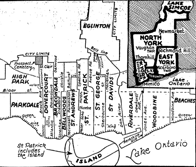
The riding was formed in 1926 from parts of the old Toronto Northeast and Toronto Southeast ridings. Its western boundary starting atToronto Harbour
Toronto Harbour or Toronto Bay is a bay on the north shore of Lake Ontario, in Toronto, Ontario, Canada. It is a natural harbour, protected from Lake Ontario waves by the Toronto Islands. Today, the harbour is used primarily for recreational b ...
went north following the line of Simcoe Street. At Queen Street West
Queen Street is a major east-west thoroughfare in Toronto, Ontario, Canada. It extends from Roncesvalles Avenue and King Street in the west to Victoria Park Avenue in the east. Queen Street was the cartographic baseline for the original east-w ...
it jogged east a block to University Avenue. It followed this street north continuing along Queen's Park Crescent East and Avenue Road north to St. Clair Avenue West. At St. Clair it turned east and went to Yonge Street. At Yonge it turned south and followed this street to Bloor Street. It then turned east following Bloor until it reached Sherbourne Street. It then followed Sherbourne back south until it met the harbour.
Prior to the 1934 election, the riding boundaries were changed. The western boundary was moved east to Bay Street. The boundary followed Bay Street north from the harbour until it curved northwest to meet Davenport Road. It followed Davenport until it met Avenue Road. It turned north following Avenue Road north skirting Upper Canada College
Upper Canada College (UCC) is an elite, all-boys, private school in Toronto, Ontario, operating under the International Baccalaureate program. The college is widely described as the country's most prestigious preparatory school, and has produce ...
on the east side until it met the old Belt Line Railway right-of-way
Right of way is the legal right, established by grant from a landowner or long usage (i.e. by prescription), to pass along a specific route through property belonging to another.
A similar ''right of access'' also exists on land held by a gov ...
. It then headed southeast following the right-of-way until it reached Yonge Street. From here it turned south following a line through the Mount Pleasant cemetery and through a ravine called the Vale of Avoca (these days it is called David Balfour Park). It followed the ravine until it reached the CPR
Cardiopulmonary resuscitation (CPR) is an emergency procedure consisting of chest compressions often combined with artificial ventilation in an effort to manually preserve intact brain function until further measures are taken to restore sponta ...
right-of-way. It headed east along this right-of-way until it reached MacLennan Avenue. It then turned south following this street and continued south on the same line when it turned into Sherbourne Street at Bloor. It continued along Sherbourne Street until it reached the harbour.
Members of Provincial Parliament
Election results
1926 boundaries
1934 boundaries

1945 boundaries
1967 boundaries
References
Notes
Citations
{{DEFAULTSORT:St. George (Ontario provincial electoral district) Former provincial electoral districts of Ontario Provincial electoral districts of Toronto