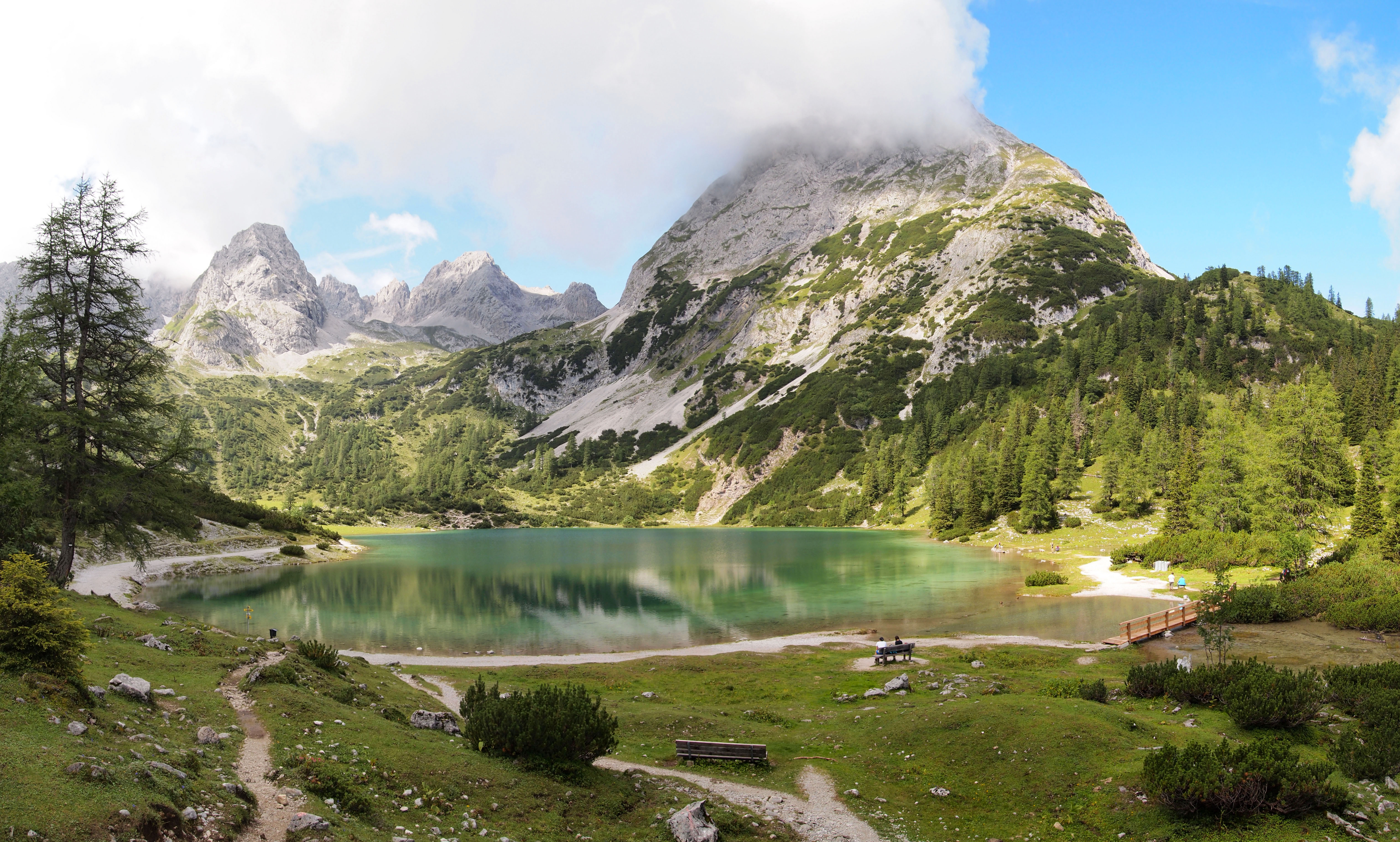
Seebensee 7 on:
[Wikipedia]
[Google]
[Amazon]
 The Seebensee is a natural high mountain lake (an ice-age affected, rock basin lake) at a height of 1,657 metres, south of
File:SeebenseeI.jpg, The Seebensee at the foot of the Vorderer Drachenkopf
File:SeebenseeII.jpg, The Seebensee in front of the Wetterstein mountains
File:SeebenseeIII.jpg, The Seebensee at the foot of the Vorderer Tajakopf
 The Seebensee is a natural high mountain lake (an ice-age affected, rock basin lake) at a height of 1,657 metres, south of
 Ehrwald
Ehrwald is a municipality in the district of Reutte in the Austrian state of Tyrol.
Geography
Ehrwald lies at the southern base of the Zugspitze (2950 meters above sea level), Germany's highest mountain, but which is shared with Austria. The town ...
in the Mieming Range
The Mieming(er) Range, Mieminger Chain (german: Mieminger Kette) or Mieminger Mountains (''Mieminger Gebirge''), is a mountain range of the Northern Limestone Alps in the Eastern Alps. It is located entirely in Austria within the state of Tyro ...
. It is surrounded by the Vorderer Tajakopf
The Vorderer Tajakopf is a 2,450-metre-high mountain in the Mieming Chain in the Austrian state of Tyrol.
The normal route to the summit runs from the Coburger Hut (1,917 m) over the ''Vorderes Tajatörl'' and the south arête. More recently ...
in the east, the Vorderer Drachenkopf in the south and the Ehrwalder Sonnenspitze in the west.
The Seebensee has no significant above-ground inflows and one outflow via the Seebenbach Falls and the Geißbach into the Loisach
The Loisach is a river that flows through Tyrol, Austria and Bavaria, Germany. Its name might be Celtic in origin, from Proto-Celtic ''*lawo'' and ''*iskā'', both of which mean "water". The Loisach goes through the great swamp .
The Loisach is a ...
river. The lake may be reached from Ehrwald on a forest track via the Ehrwalder Alm, via the Seeben Klettersteig, a difficult klettersteig
A via ferrata (Italian language, Italian for "iron path", plural ''vie ferrate'' or in English ''via ferratas'') is a protected climbing route found in the Alps and certain other locations. The term "via ferrata" is used in most countries and ...
, or via one of the two protected mountain trails '' Hoher Gang'' or '' Immensteig''. From Biberwier
Biberwier is a municipality with 612 inhabitants (as of 1 January 2019) in the district of Reutte (district), Reutte in the Austrian state of state of Tyrol, Tyrol. The municipality is located in the district court Reutte.
Geography
The village ...
, the lake may be reached via the arête of the Biberwierer Scharte, and from Leutasch
Leutasch is a municipality in the northern part of the district Innsbruck-Land in the Austrian state of Tyrol about 30 km northwest of Innsbruck and 10 km northwest of Seefeld in Tirol
Geography
The village lies in the Leutaschtal, a ...
through the Gaistal valley.
Near the lake (to the northeast) lies the managed alpine pasture of Seebenalm. To the south on a rock terrace above the lake is the Coburger Hut
The Coburger Hut (german: Coburger Hütte) is an Alpine hut owned by the Coburg Branch of the German Alpine Club. It is located in the Mieming Range in the Austrian state of Tyrol (state), Tyrol and lies only a few metres in height above the lak ...
owned by the German Alpine Club
The German Alpine Club (german: links=no, Deutscher Alpenverein, DAV for short) is the world's largest climbing association and the eighth-largest sporting association in Germany. It is a member of the German Olympic Sports Confederation and the ...
.
The surface of the lake covers around 6.5 hectares
The hectare (; SI symbol: ha) is a non-SI metric unit of area equal to a square with 100-metre sides (1 hm2), or 10,000 m2, and is primarily used in the measurement of land. There are 100 hectares in one square kilometre. An acre is ab ...
, but it used to be larger. As a result of soil and vegetation analyses it has been deduced that there was a large area southeast of the lake which used to be part of it (today easily visible, especially from above, as a mainly grassy plain) but which has now silted up.
Gallery
References
Literature and maps
* ''Tirol''. Kompass Digital-map (No. K 4292, 1 DVD ROM). Kompass-Karten-GmbH, Rum/Innsbruck, 2007, . *Alpine Club map
Alpine Club maps (german: Alpenvereinskarten, often abbreviated to ''AV-Karten'' i.e. AV maps) are specially detailed maps for summer and winter mountain climbers (mountaineers, hikers and ski tourers). They are predominantly published at a scale o ...
1:25,000 scale, Sheet 4/2, ''Wetterstein- und Mieminger Gebirge'', .
* Helmut Pflanzelt: ''Wettersteingebirge. Ein Führer für Täler, Hütten und Berge''. Included work: Siegfried Aeberli: ''Mieminger Kette''. 2nd edn., reviewed and enhanced by the publisher. Alpine Club Guide
The ''Alpine Club Guides'' (german: Alpenvereinsführer, commonly shortened to ''AV Führer'' or ''AVF'') are the standard series of Alpine guides that cover all the important mountain groups in the Eastern Alps. They are produced jointly by the Ge ...
, Series: Nördliche Kalkalpen. Rother, Munich, 1978, .
* {{ANNO, oav, 00, 00, 1887, 330, AUTOR=Ferd(inand) Kilger, ZUSATZ=(Band XVIII), Seebensee, Drachensee und Grünsteinscharte. Mit zwei Holzschnitten, ALTSEITE=313–316., anno-plus=ja.
LSeebensee
Lakes of Tyrol (state)
Mieming Range