Rhinluch on:
[Wikipedia]
[Google]
[Amazon]

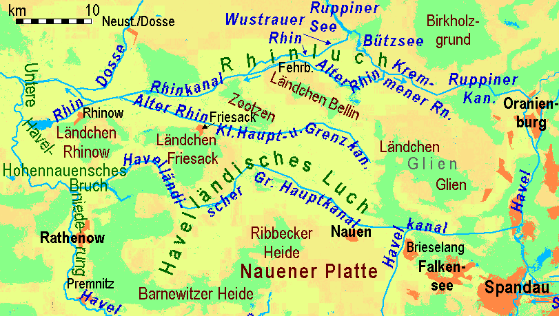
 The Rhinluch is a
Society for the Preservation of the Upper Rhinluch (''Landschaftsförderverein Oberes Rhinluch'')
{{Authority control Regions of Brandenburg Havelland

fen
A fen is a type of peat-accumulating wetland fed by mineral-rich ground or surface water. It is one of the main types of wetlands along with marshes, swamps, and bogs. Bogs and fens, both peat-forming ecosystems, are also known as mires. T ...
landscape in the German state of Brandenburg
Brandenburg (; nds, Brannenborg; dsb, Bramborska ) is a states of Germany, state in the northeast of Germany bordering the states of Mecklenburg-Vorpommern, Lower Saxony, Saxony-Anhalt, and Saxony, as well as the country of Poland. With an ar ...
, bisected by the river Rhin
The Rhin is a long river in Brandenburg, Germany, right tributary to the river Havel. It flows through the city Neuruppin and several lakes. A few kilometres downstream from Rhinow it flows into the Havel, about upstream from where the Have ...
to which it owes its name. This wetland region lies north of Fehrbellin
Fehrbellin is a municipality in Germany, located 60 km NW of Berlin. It had 9,310 inhabitants as of 2005, but has since declined to 8,606 inhabitants in 2012.
History
In 1675, the Battle of Fehrbellin was fought there, in which the troops o ...
in the county of Ostprignitz-Ruppin
Ostprignitz-Ruppin is a ''Kreis'' (district) in the northwestern part of Brandenburg, Germany. Neighboring are (from north clockwise) the districts Müritz and Mecklenburg-Strelitz in Mecklenburg-Western Pomerania, the districts
Oberhavel and Have ...
. The upper Rhinluch covers an area of about . The suffix '' luch'' is used to describe several wet areas in the state of Brandenburg, in which, prior to the advent of modern drainage systems, water remained largely stagnant rather than flowing.
The Rhinluch was formed during the last ice age
An ice age is a long period of reduction in the temperature of Earth's surface and atmosphere, resulting in the presence or expansion of continental and polar ice sheets and alpine glaciers. Earth's climate alternates between ice ages and gree ...
and its post-glacial period. About 16,000 years ago, the Eberswald ''urstromtal
An ''urstromtal'' (plural: ''Urstromtäler'') is a type of broad glacial valley, for example, in northern Central Europe, that appeared during the ice ages, or individual glacial periods of an ice age, at the edge of the Scandinavian ice sheet and ...
'' was formed by the meltwaters of the glacial
A glacial period (alternatively glacial or glaciation) is an interval of time (thousands of years) within an ice age that is marked by colder temperatures and glacier advances. Interglacials, on the other hand, are periods of warmer climate betw ...
ice sheet as they drained away to the sea. Later, this broad river valley dried up as the ice sheet retreated during the late ice age. In the land that makes up the present-day Rhinluch, lakes initially formed in individual places, especially where there were dead ice
Death is the irreversible cessation of all biological functions that sustain an organism. For organisms with a brain, death can also be defined as the irreversible cessation of functioning of the whole brain, including brainstem, and brain ...
kettle hole
A kettle (also known as a kettle lake, kettle hole, or pothole) is a depression/hole in an outwash plain formed by retreating glaciers or draining floodwaters. The kettles are formed as a result of blocks of dead ice left behind by retreating gla ...
s. Over the course of time, these became bogs through the natural silting
Siltation, is water pollution caused by particulate terrestrial clastic material, with a particle size dominated by silt or clay. It refers both to the increased concentration of suspended sediments and to the increased accumulation (temporary or ...
up process. In addition, during the post-glacial period, there was a widespread formation of swamp
A swamp is a forested wetland.Keddy, P.A. 2010. Wetland Ecology: Principles and Conservation (2nd edition). Cambridge University Press, Cambridge, UK. 497 p. Swamps are considered to be transition zones because both land and water play a role in ...
s (''Versumpfungsmooren'') on the sands of the ''urstromtal''. Not until man appeared, however, did these moors become pastures and meadows as a result of land improvement
Land development is the alteration of landscape in any number of ways such as:
* Changing landforms from a natural or semi-natural state for a purpose such as agriculture or House, housing
* subdivision (land), Subdividing real estate into Lot (re ...
measures. The easternmost outlier of the Rhinluch is the Kremmener Luch
The Kremmener Luch is a shallow fen, known locally as a '' luch'', between the Glien plateau (near Berlin) in the south, and the Beetzer Heath in the north. The western Rhin
The Rhin is a long river in Brandenburg, Germany, right tributar ...
.
The Rhinluch is home to the extremely rare European pond turtle
The European pond turtle (''Emys orbicularis''), also called commonly the European pond terrapin and the European pond tortoise, is a species of long-living freshwater turtle in the family Emydidae. The species is endemic to the Western Palearct ...
.
The Brandenburg poet, Theodor Fontane
Theodor Fontane (; 30 December 1819 – 20 September 1898) was a German novelist and poet, regarded by many as the most important 19th-century German-language realist author. He published the first of his novels, for which he is best known toda ...
, described the Rhinluch thus in his ''Wanderungen durch die Mark Brandenburg
''Wanderungen durch die Mark Brandenburg'' ("Ramblings through Brandenburg", "Rambles in Brandenburg" or "Walks through the March of Brandenburg") is a five-volume travelogue by the German writer Theodor Fontane, originally published in 1862&ndash ...
'':
External links
Society for the Preservation of the Upper Rhinluch (''Landschaftsförderverein Oberes Rhinluch'')
{{Authority control Regions of Brandenburg Havelland