Philipsburg, Sint Maarten on:
[Wikipedia]
[Google]
[Amazon]
Philipsburg () is the main town and
 The main shopping district, Front Street, is in the heart of the city. The city also has a port that is visited by many cruise liners.
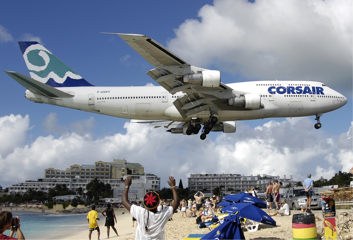
 World-famous for its close photographs of landing aircraft,
Philipsburg Jubilee Library, Public Library of St. Maarten
{{Authority control Populated places in Sint Maarten Capitals in the Caribbean Populated places established in 1763 1763 establishments in North America Cruise seaports
capital
Capital and its variations may refer to:
Common uses
* Capital city, a municipality of primary status
** Capital region, a metropolitan region containing the capital
** List of national capitals
* Capital letter, an upper-case letter
Econom ...
of Sint Maarten
Sint Maarten () is a Countries of the Kingdom of the Netherlands, constituent country of the Kingdom of the Netherlands located in the Caribbean region of North America. With a population of 58,477 as of June 2023 on an area of , it encompasses ...
, a constituent country of the Kingdom of the Netherlands
The Kingdom of the Netherlands (, ;, , ), commonly known simply as the Netherlands, is a sovereign state consisting of a collection of constituent territories united under the monarch of the Netherlands, who functions as head of state. The re ...
. The town is on a narrow stretch of land between Great Bay and the Great Salt Pond. It functions as the commercial center of Saint Martin island, whereof Sint Maarten encompasses the southern half. , it had 1,894 inhabitants.
History
Philipsburg was founded in 1763 by John Philips, a Scottish captain in the Dutch navy; the settlement soon became a centre of international trade. Two historic forts bear witness to Philipsburg's strategic importance in St. Maarten's history:Fort Amsterdam
Fort Amsterdam, (later, Fort George among other names) was a fortification on the southern tip of Manhattan Island at the confluence of the Hudson River, Hudson and East River, East rivers in what is now New York City. The fort and the island ...
and Fort Willem.
Tourism
 The main shopping district, Front Street, is in the heart of the city. The city also has a port that is visited by many cruise liners.
Transport
Princess Juliana International Airport
 World-famous for its close photographs of landing aircraft,
 Princess Juliana International Airport
Princess Juliana International Airport is the main airport on the Caribbean island of Saint Martin. The airport is located on the Dutch side of the island, in the country of Sint Maarten, close to the shore of Simpson Bay Lagoon. In 2015, the ...
(IATA
The International Air Transport Association (IATA ) is an airline trade association founded in 1945. IATA has been described as a cartel since, in addition to setting technical standards for airlines, IATA also organized tariff conferences tha ...
: SXM, ICAO
The International Civil Aviation Organization (ICAO ) is a specialized agency of the United Nations that coordinates the principles and techniques of international air navigation, and fosters the planning and development of international sch ...
: TNCM), west of Philipsburg, has become a tourist destination in its own right. Jet blast from departing aircraft is another 'attraction' as it creates artificial waves. However, jet blast is physically hazardous so viewers need to exercise caution; local authorities have placed a warning on the airport's fence to alert people to the dangers of jet blast.
Education
Schools include: *Oranje School (public primary) *Sr. Borgia Primary (subsidized primary) *St. Joseph Primary (subsidized primary) * Sundial School (subsidized secondary) Philipsburg Jubilee Library is in Philipsburg.Climate
Philipsburg has atropical savanna climate
Tropical savanna climate or tropical wet and dry climate is a tropical climate sub-type that corresponds to the Köppen climate classification categories ''Aw'' (for a dry "winter") and ''As'' (for a dry "summer"). The driest month has less than ...
(Köppen Köppen is a German surname. Notable people with the surname include:
* Bernd Köppen (1951–2014), German pianist and composer
* Carl Köppen (1833-1907), German military advisor in Meiji era Japan
* Edlef Köppen (1893–1939), German author ...
''Aw''), and is drier than most parts of the northeastern Caribbean due to a rain shadow
A rain shadow is an area of significantly reduced rainfall behind a mountainous region, on the side facing away from prevailing winds, known as its leeward side.
Evaporated moisture from body of water, bodies of water (such as oceans and larg ...
from the island's mountains, drying the northeast trade winds
The trade winds or easterlies are permanent east-to-west prevailing winds that flow in the Earth's equatorial region. The trade winds blow mainly from the northeast in the Northern Hemisphere and from the southeast in the Southern Hemisphere ...
. The driest months are from January to July, and the wettest from September to November, when hurricane
A tropical cyclone is a rapidly rotating storm system with a low-pressure area, a closed low-level atmospheric circulation, strong winds, and a spiral arrangement of thunderstorms that produce heavy rain and squalls. Depending on its ...
s are a frequent occurrence in the region.
See also
* List of Designated Monuments in PhilipsburgReferences
External links
Philipsburg Jubilee Library, Public Library of St. Maarten
{{Authority control Populated places in Sint Maarten Capitals in the Caribbean Populated places established in 1763 1763 establishments in North America Cruise seaports