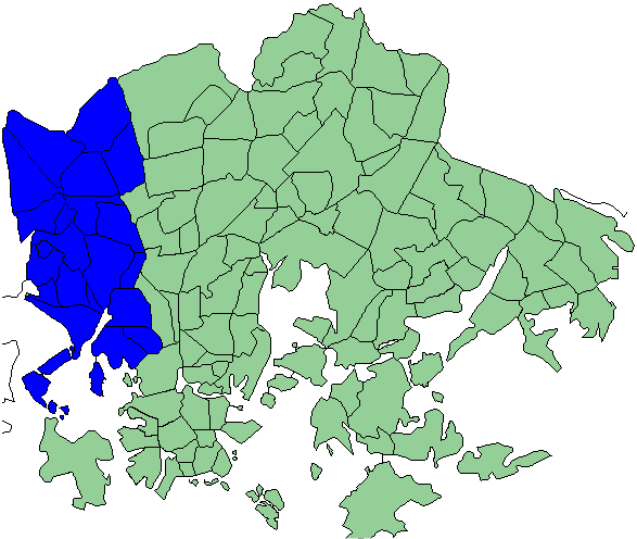
Läntinen Suurpiiri on:
[Wikipedia]
[Google]
[Amazon]
 Läntinen suurpiiri ( sv, Västra stordistriktet, en, Western major district) is one of the seven major districts of
 Läntinen suurpiiri ( sv, Västra stordistriktet, en, Western major district) is one of the seven major districts of
 Helsinki
Helsinki ( or ; ; sv, Helsingfors, ) is the Capital city, capital, primate city, primate, and List of cities and towns in Finland, most populous city of Finland. Located on the shore of the Gulf of Finland, it is the seat of the region of U ...
, Finland
Finland ( fi, Suomi ; sv, Finland ), officially the Republic of Finland (; ), is a Nordic country in Northern Europe. It shares land borders with Sweden to the northwest, Norway to the north, and Russia to the east, with the Gulf of Bo ...
. It covers five subdistricts: Reijola, Munkkiniemi
Munkkiniemi ( sv, Munksnäs, Helsinki slang: ''Munkka'') is a neighbourhood in Helsinki. Subdivisions within the district are Vanha Munkkiniemi, Kuusisaari, Lehtisaari, Munkkivuori, Niemenmäki and Talinranta.
The land in Munkkiniemi was from the ...
, Haaga
Haaga ( sv, Haga köping) is a district and a former municipality in the Western major district of Helsinki with a population of 25,435.http://www.hel2.fi/tietokeskus/helsinki_alueittain_2005/203Haaga.pdf 2005 statistics about Haaga
Haaga is d ...
, Pitäjänmäki
Pitäjänmäki () is a district located on the westernmost district of Helsinki, Finland, near the border with Espoo. There are many IT and machine manufacturing companies in the area, especially around the Valimo railway station. Such compani ...
and Kaarela.http://www.hel2.fi/tietokeskus/helsinki_alueittain_2005/2L%C3%A4ntinen.pdf Western major district information , western major district has 98,545 inhabitants living in an area of 30.4 km2.http://www.hel2.fi/tietokeskus/helsinki_alueittain_2005/Helsinki.pdf Information about helsinki major districts
Each of the five districts has several subareas:
* Reijola district http://www.hel2.fi/tietokeskus/helsinki_alueittain_2005/201Reijola.pdf Reijola district information
** Laakso
** Ruskeasuo
Ruskeasuo (Brunakärr in Swedish, verbatim "Brown swamp") is a neighbourhood of Helsinki (Helsingfors in Swedish), about 3 kilometres north of the city center.
With a population of 2670 (year 2005) Ruskeasuo is a rather quiet residential area. ...
** Meilahti
Meilahti (in Swedish Mejlans) is a neighbourhood of Helsinki between Mannerheimintie (the main entrance road to Helsinki) and a bay named Seurasaarenselkä. Most of the houses in Meilahti were built in the 1930s and 1940s. Meilahti is home to ...
* Munkkiniemi district http://www.hel2.fi/tietokeskus/helsinki_alueittain_2005/202Munkkiniemi.pdf Munkkiniemi district information
** Niemenmäki
Niemenmäki ( sv, Näshöjden) is a quarter of the Munkkiniemi neighbourhood in Helsinki. Niemenmäki was constructed in the early 1960s. The nearby Shopping center provides everyday services to Niemenmäki inhabitants. Huopalahdentie road separ ...
** Munkkivuori
Munkkivuori ( sv, Munkshöjden, literally 'Monk Mountain') is a quarter of the Munkkiniemi neighbourhood in Helsinki. The buildings and the plan of site are typical of the late 1950s. Most of the residential buildings in Munkkivuori are within a l ...
** Talinranta
Talinranta ( sv, Talistranden) is a neighbourhood in Munkkiniemi district of Helsinki, Finland. It is located west from Munkkivuori and south from Tali. In south, Finnish national road 1 separates Talinranta from Vanha Munkkiniemi
Vanha Munk ...
** Vanha Munkkiniemi
Vanha Munkkiniemi ( Finnish), Gamla Munksnäs (Swedish), both of them meaning ′Old Munkkiniemi′, is a neighborhood that contains the original part of Munkkiniemi
Munkkiniemi ( sv, Munksnäs, Helsinki slang: ''Munkka'') is a neighbourhood in ...
** Kuusisaari
Kuusisaari ( Finnish), Granö ( Swedish) is an island and a neighborhood of Helsinki, Finland
Finland ( fi, Suomi ; sv, Finland ), officially the Republic of Finland (; ), is a Nordic country in Northern Europe. It shares land borders ...
** Lehtisaari
* Haaga district http://www.hel2.fi/tietokeskus/helsinki_alueittain_2005/203Haaga.pdf Haaga district information
** Etelä-Haaga
** Kivihaka
** Pohjois-Haaga
** Lassila
* Pitäjänmäki district http://www.hel2.fi/tietokeskus/helsinki_alueittain_2005/204Pitäjänmäki.pdf Pitäjänmäki district information
** Tali
** Pajamäki
** Pitäjänmäen teollisuusalue
** Reimarla
** Marttila
Marttila (; sv, S:t Mårtens, i.e. "Saint Martin's") is a municipality of Finland. It is located in the province of Western Finland and is part of the Southwest Finland region. The municipality has a population of () and covers an area of of w ...
** Konala
Konala ( Finnish), Kånala ( Swedish) is a subdistrict of Helsinki, Finland. Konala has about 4500 inhabitants and about 3000 jobs. Konala is situated in north-western Helsinki, north of Ring I road and Pitäjänmäki, west of Malminkartano and ...
* Kaarela district http://www.hel2.fi/tietokeskus/helsinki_alueittain_2005/205Kaarela.pdf Kaarela district information
** Kannelmäki
** Malminkartano
Malminkartano (Malmgård in Swedish) is a suburb and a quarter in the western part of Helsinki city, part of the Kaarela neighbourhood. Vantaankosken rata, the railway of Vantaankoski, has a station in Malminkartano. The suburb's artificial hill ...
** Maununneva
** Hakuninmaa
References
Major districts of Helsinki {{Finland-geo-stub