Lamu–Garissa–Isiolo Road on:
[Wikipedia]
[Google]
[Amazon]
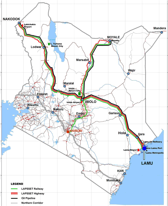
 Lamu–Garissa–Isiolo Road, is a road in Kenya, and is part of the Lamu-Garissa-Isiolo-Lokichar Road, which itself is a component of the
Website of LAPSSET Corridor Development Authority (LCDA)
{{DEFAULTSORT:Lamu-Garissa-Isiolo Road Roads in Kenya Lamu Lamu County Tana River County Garissa County Isiolo County
 Lamu–Garissa–Isiolo Road, is a road in Kenya, and is part of the Lamu-Garissa-Isiolo-Lokichar Road, which itself is a component of the
 Lamu Port and Lamu-Southern Sudan-Ethiopia Transport Corridor
The Lamu Port-South Sudan-Ethiopia-Transport (LAPSSET) Corridor project, also known as Lamu corridor is a transport and infrastructure project in Kenya that, when complete, will be the country's second transport corridor. Kenya's other transpor ...
(LAPSSET) Project.
Location
The road starts in the port city ofLamu
Lamu or Lamu Town is a small town on Lamu Island, which in turn is a part of the Lamu Archipelago in Kenya. Situated by road northeast of Mombasa that ends at Mokowe Jetty, from where the sea channel has to be crossed to reach Lamu Isla ...
and proceeds in a northwesterly direction through the town of Bura, Tana River County, (not to be confused with ''Bura, Garissa County'') and continue on to the town of Garissa
Garissa ( Arabic: قارسا) is the capital of Garissa County, Kenya. It is situated in the former North Eastern Province.
Geography
The Tana River, which rises in Mount Kenya east of Nyeri, flows through Garissa. The Bour-Algi Giraffe ...
. At Garissa, the road continues its northwesterly direction to Mado Gashi. Here it takes a southwesterly direction through Garba Tula
Garba Tula (also spelled Garbatulla) and popularly nicknamed by the locals ''El Borte'' (meaning ''Bitter Well'' , probably due to its salty water) is a town in Isiolo County, Northern Kenya. The town has an urban population of about 5,500.
In 20 ...
, to end at Isiolo
Isiolo is a town in Isiolo County, of which it is the capital. It is located in the upper eastern region of Kenya and is geographically considered the center of the country Kenya. It lies 285 kilometers north of the capital Nairobi. The town gr ...
, a total distance of approximately . The approximate coordinates of the road, immediately north of the town of Garissa are:0°22'14.0"S, 39°42'37.0"E (Latitude:-0.370556; Longitude: 39.710278).
Overview
This road is part of Lapsset corridor highway project. AtIsiolo
Isiolo is a town in Isiolo County, of which it is the capital. It is located in the upper eastern region of Kenya and is geographically considered the center of the country Kenya. It lies 285 kilometers north of the capital Nairobi. The town gr ...
, this road links with the Isiolo-Lokichar Road, which is also planned. The road the joins with the existing Eldoret-Juba Highway, which will lead to the border with South Sudan
South Sudan (), officially the Republic of South Sudan, is a landlocked country in East Africa. It is bordered on the north by Sudan; on the east by Ethiopia; on the south by the Democratic Republic of the Congo, Uganda and Kenya; and on the ...
. Also at Isiolo the Lamu–Garissa–Isiolo Road will connect with the planned Isiolo-Moyale Road leading to the border with Ethiopia
Ethiopia, officially the Federal Democratic Republic of Ethiopia, is a landlocked country located in the Horn of Africa region of East Africa. It shares borders with Eritrea to the north, Djibouti to the northeast, Somalia to the east, Ken ...
at Moyale
Moyale is a city situated on the border between Ethiopia and Kenya. In Ethiopia, it serves as the administrative centre for two Ethiopian woredas: Moyale of the Oromia Region and Moyale of the Somali Region. In Kenya, it is the largest tow ...
.
In October 2016, a consortium of lenders, led by the Development Bank of South Africa agreed to lend the estimated Kenya Sh:71 billion (about US$700 million), needed to construct this road.
Urban centres
The following urban centres lie along the route of the planned Lamu–Garissa–Isiolo Road: (1) Lamu Port (2) Bura, Garrisa, Kachiuru and Ndumuru in Meru County, Mado Gashi, El Dera, Gaba Tula and Isiolo.Intersections
These are the major intersections along this road: (1) The Mombasa–Garissa Road at Garissa (2) The Thika–Liboi Road at Garissa (3) The Garissa–Nuno–Modogashe–Wajir Road at Garissa (4) The Isiolo-Mandera Road at Mado Gashi. Intersections with planned roads include: (1) The Isiolo-Lokichar Road at Isiolo and (2) The Isiolo-Moyale Road also at Isiolo.See also
*Trans-African Highway network
The Trans-African Highway network comprises transcontinental road projects in Africa being developed by the United Nations Economic Commission for Africa (UNECA), the African Development Bank (ADB), and the African Union in conjunction with reg ...
*List of roads in Kenya
The following is a list of the national roads in Kenya, under the jurisdiction of the Kenya National Highway Authority (KeNHA). KenHa classifies International Trunk Roads as Class ‘A’ and National Trunk Roads as Class ‘B’. The list is not ...
References
External links
Website of LAPSSET Corridor Development Authority (LCDA)
{{DEFAULTSORT:Lamu-Garissa-Isiolo Road Roads in Kenya Lamu Lamu County Tana River County Garissa County Isiolo County