Kühlung on:
[Wikipedia]
[Google]
[Amazon]


 The Kühlung is a forested ridge, up to , in the north German state of
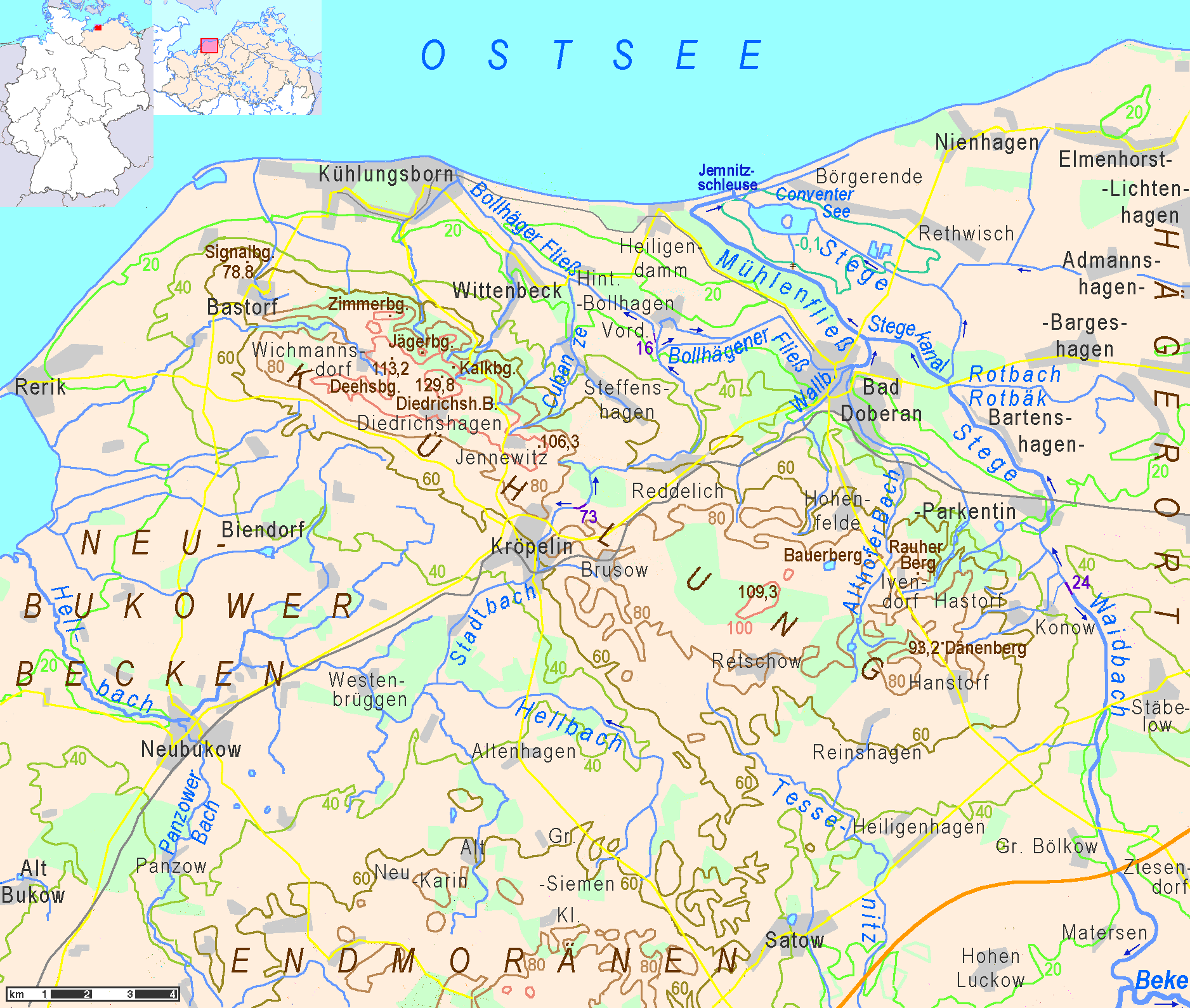
Map of classified sections of the landscape for the Landschaftsentwicklungslpan (natural landscape development plan) for central Mecklenburg and Rostock (UM M-V 2003) map of classified areas (pdf)
/ref>


Mecklenburg-Vorpommern
Mecklenburg-Vorpommern (MV; ; nds, Mäkelborg-Vörpommern), also known by its anglicized name Mecklenburg–Western Pomerania, is a state in the north-east of Germany. Of the country's sixteen states, Mecklenburg-Vorpommern ranks 14th in po ...
. The name is derived from the word ''Kuhlen'' (referring to the extensive fissuring of the northern slope).
Geography
The Kühlung is situated in the district ofRostock
Rostock (), officially the Hanseatic and University City of Rostock (german: link=no, Hanse- und Universitätsstadt Rostock), is the largest city in the German state of Mecklenburg-Vorpommern and lies in the Mecklenburgian part of the state, c ...
, southeast of the Bay of Mecklenburg
The Bay of Mecklenburg ( or ''Mecklenburgische Bucht''; ), also known as the Mecklenburg Bay or Mecklenburg Bight, is a long narrow basin making up the southwestern finger-like arm of the Baltic Sea, between the shores of Germany to the south a ...
, south of the Baltic Sea
The Baltic Sea is an arm of the Atlantic Ocean that is enclosed by Denmark, Estonia, Finland, Germany, Latvia, Lithuania, Poland, Russia, Sweden and the North and Central European Plain.
The sea stretches from 53°N to 66°N latitude and from ...
coast, and south and west of Bad Doberan and its seaside resort Kühlungsborn
Kühlungsborn () is a ''Seebad'' (seaside resort) town in the Rostock district, in Mecklenburg-Vorpommern, Germany. It is situated on the Baltic Sea coast, 11 km northwest of Bad Doberan, and 25 km northwest of Rostock.
The town has an ...
. The major part of this hilly landscape forms a protected area
Protected areas or conservation areas are locations which receive protection because of their recognized natural, ecological or cultural values. There are several kinds of protected areas, which vary by level of protection depending on the ena ...
. The Kühlung is part of the Baltic Uplands
The Baltic UplandsDickinson, Robert E. (1964). ''Germany: A regional and economic geography'' (2nd ed.). London: Methuen, p. 614. . (german: Baltischer Landrücken or ''Nördlicher Landrücken'') is a chain of morainic hills about wide that borde ...
that extend along the southern coast of Baltic Sea from Ostholstein
Ostholstein (; da, Østholsten) is a district in Schleswig-Holstein, Germany. It is bounded by (from the southwest and clockwise) the districts of Stormarn, Segeberg and Plön, the Baltic Sea and the city of Lübeck.
History
The district was es ...
to the Baltic republics.
The ridge extends from northwest to southeast for about 23 kilometres and is between three and eight kilometres wide. The northwestern part is a ridge, eleven kilometres long, called the ''Driedrichshagener Berge'' ("Driedrichshagen Hills"), or – colloquially – simply "Kühlung". The ''Driedrichshagener Berge'' begin near the sea with the hill known as the ''Bastorfer Signalberg'' (height 78.8 metres), on which stands the landmark of the Bastorf Lighthouse. The northern slope of this ridge with its short valleys and deep, natural pits ( Ger.: "Kuhlen") gave its name to the whole landscape. This slope is covered by a contiguous strip of forest, between 500 metres and one kilometre wide, with a total area of 6,300 hectares. Another important forest on the Kühlung is the ''Hütter Wohld'' in the east. In its longest valley there is a series of ponds, the ''Hüttener Klosterteiche'', that are under a higher level of protection than the rest of the Kühlung.
The ''Hütter Wohld'' is situated on the eastern edge of the eastern Kühlung, called ''Ivendorfer Höhen'' ("Ivendorf Heights"). This little upland is almost as broad as it is long. On its heights there are forests on the soil of former mosses.
A little over half the Kühlung is used for fields and pasture./ref>
Geology
The hills and the unusual soil composition of the Kühlung were created during the Last glacial period of Europe by the compression of moraines. The natural pits in the northern slope that were created by blocks of slowly melting ice, when the glacier was retreating.Hills
In the Kühlung, some of the sites referred to as a "Berg" ( Eng.: hill or mountain) are merely promontories, while some of its summits are unnamed. Some of the main hills with heights above sea level: * Diedrichshagener Berg (129.8 m), highest summit in the range * Deehsberg (113.2 m) * Kalkberg (Kühlung), Kalkberg (111.8 m) * Großer Jägerberg (110.3 m) * Zimmerberg (109.7 m) * unnamed high point of the ''Ivendorfer Höhen'' (109.7 m) * Jägerberg (100.3 m NHN) * Anningsbarg (99.3 m NHN) * Dänenberg (93.,2 m, ''Ivendorfer Höhen'') * Bauerberg (92.8 m, ''Ivendorfer Höhen'') * Rauher Berg (90.2 m, ''Ivendorfer Höhen'') * Schlossberg (86 m) * Budenberg (82.8 m NHN) * Franzosenberg (82 m) * Bastorfer Signalberg (78.8 m NHN) with Bastorf LighthousePlaces
*Kühlungsborn
Kühlungsborn () is a ''Seebad'' (seaside resort) town in the Rostock district, in Mecklenburg-Vorpommern, Germany. It is situated on the Baltic Sea coast, 11 km northwest of Bad Doberan, and 25 km northwest of Rostock.
The town has an ...
some way to the north
* Bad Doberan to the east
* Kröpelin
Kröpelin is a town in the Rostock district, in Mecklenburg-Western Pomerania, Germany. It is situated 9 km southwest of Bad Doberan, and 23 km west of Rostock
Rostock (), officially the Hanseatic and University City of Rostock (g ...
to the south, near the centre
* Rerik
Rerik (, formerly Alt-Gaarz) is a town in the Rostock district, in Mecklenburg-Western Pomerania, Germany. It is situated on the Baltic Sea coast, 19 km west of Bad Doberan, and 27 km northeast of Wismar. In 1938, Rerik was named after ...
some way to the west
External links
{{DEFAULTSORT:Kuhlung Rostock (district) Forests and woodlands of Mecklenburg-Western Pomerania