|
Baltic Uplands
The Baltic UplandsDickinson, Robert E. (1964). ''Germany: A regional and economic geography'' (2nd ed.). London: Methuen, p. 614. . (german: Baltischer Landrücken or ''Nördlicher Landrücken'') is a chain of morainic hills about wide that border the southern Baltic Sea from Jutland to Estonia. Geography The uplands, which reach a height of at Wieżyca (mountain), Wieżyca (german: Turmberg), form the western part of the East European Plain. To the north they descend steadily into the Gulf of Finland. Towards the east they merge into the Belarusian Ridge; to the southeast they sink gradually into the Polesian depression. To the south the terrain falls away into the extensive Vistula basin. To the west the Uplands are bordered by the North German Plain and in the northwest the terrain drops away westwards from the Schleswig-Holstein Uplands into the North Sea. The Baltic Uplands are crossed by the rivers Oder, Vistula, Neman River, Memel and Düna. Their component hill ranges ... [...More Info...] [...Related Items...] OR: [Wikipedia] [Google] [Baidu] |
Angeln
Anglia (German and Low German: ''Angeln''; Danish and South Jutlandic: ''Angel''; ang, Engla land) is a small peninsula on the eastern coast of Jutland (the Cimbric Peninsula). Jutland consists of the mainland of Denmark and the northernmost German state of Schleswig-Holstein. Anglia belongs to the region of Southern Schleswig, which constitutes the northern part of Schleswig-Holstein, and protrudes into the Bay of Kiel of the Baltic Sea. To the south, Anglia is separated from the neighbouring peninsula of Swania (Ger. ''Schwansen'', Dan. ''Svans'' or ''Svansø'') by the Sly Firth (Ger. ''Schlei'', Dan. ''Sli''), and to the north from the Danish peninsula of Sundeved (Ger. ''Sundewitt'') and the Danish island of Als (Ger. ''Alsen'') by the Flensburg Firth (Ger. ''Flensburger Förde'', Dan. ''Flensborg Fjord''). The landscape is hilly, dotted with numerous lakes. Whether ancient Anglia conformed to the borders of the Anglian Peninsula is uncertain. It may have been somewh ... [...More Info...] [...Related Items...] OR: [Wikipedia] [Google] [Baidu] |
Upland (other)
Upland or Uplands may refer to: Geography *Hill, an area of higher land, generally *Highland, an area of higher land divided into low and high points *Upland and lowland, conditional descriptions of a plain based on elevation above sea level *In limnology and freshwater biology, the terrestrial ecosystems above the high water mark (wetland) of a riparian zone or lakeshore Places Australia * Upland, Queensland, a locality in the Barcaldine Region * Desert Uplands, a bio-region in Queensland Canada * CFB Uplands, a former Canadian Forces Base located in Ottawa, Ontario ** Uplands, Ottawa, a neighbourhood in Ottawa * Uplands, Greater Victoria, a Vancouver Island neighbourhood in the northeast Oak Bay, British Columbia ** Uplands Park, an undeveloped natural reserve in the Uplands neighbourhood * Uplands Ski Centre, a ski area in Thornhill, Ontario * The Uplands, Edmonton, a future neighbourhood * Uplands, Ontario, a neighbourhood in the City of London, Ontario Germany * Upland ( ... [...More Info...] [...Related Items...] OR: [Wikipedia] [Google] [Baidu] |
Rominter Heide
Romincka Forest ( pl, Puszcza Romincka, lt, Romintos giria), also known as Krasny Les (russian: Красный лес) or Rominte Heath (german: Rominter Heide), is an extended forest and heath landscape stretching from the southeast of Russian Kaliningrad Oblast to the northeast of Polish Warmian-Masurian Voivodeship. Etymology The Polish and German names of the forest, like the '' Rominta/Rominte'' river and the settlement of '' Rominty/Rominten'', are derived from the Lithuanian syllable ''rom'', meaning calm, as the forest is in the land called Lithuania Minor. The Russian name, ''Krasnyy Les'', means "Red Forest". Geography The total area of the Romincka landscape is about , stretching from the Masurian Lake District in the southwest up to the border with Lithuania at Lake Vištytis in the east. The southern Polish part (about one-third of the area) comprises a protected zone known as Puszcza Romincka Landscape Park. The Krasnaya River flows through the Romincka Forest. ... [...More Info...] [...Related Items...] OR: [Wikipedia] [Google] [Baidu] |
Tucheler Heide
The Tuchola Forest, also known as Tuchola Pinewoods or Tuchola Conifer Woods, (the latter a literal translation of pl, Bory Tucholskie; csb, Tëchòlsczé Bòrë; german: Tuchler or Tucheler Heide) is a large forest complex near the town of Tuchola in northern Poland, which lies between the Brda and Wda Rivers, within the Gdańsk Pomerania region. The largest towns in the area are Czersk and Tuchola. The designation may also refer to the eponymous historical land and ethnocultural region, World War II battle, geomorphological mesoregion, phytogeographic landscape region and syntaxonomical subregion, nature and forest mesoregion, promotional forest complex, Biosphere Reserve, Natura 2000 Special Protection Area, national park, LEADER/CLLD local action group, or a number of local associations. Geographical extent varies greatly among these units or entities. Geography, nature and ecology With 3,200 km² of dense spruce and pine forest, the area is one of the biggest forests in ... [...More Info...] [...Related Items...] OR: [Wikipedia] [Google] [Baidu] |
Schorfheide
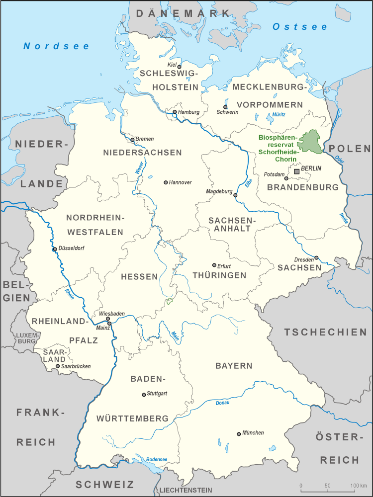
The Schorfheide-Chorin Biosphere Reserve, often shortened to Schorfheide, is a biosphere reserve in the German State of Brandenburg near the Polish border. The reserve was established on 1 October 1990 following the German Reunification and is under the protection of the UNESCO Man and Biosphere Reserve Programme. It stretches over the German districts of Barnim, Uckermark, Märkisch-Oderland and Oberhavel and incorporates an area of . Notable towns are Eberswalde, Joachimsthal and Friedrichswalde. The core area of the reserve is formed by the Schorfheide forest, one of the largest cohesive woodlands in Germany. History From the Early Middle Ages until the period of the Thirty Years' War, the area fell under the responsibility of the cloister of Chorin which led to a cultivation of suitable spaces. Forest clearances took place for the sake of producing weapons for the Prussian army, but the woods were usually afforested. Large parts of the woodland were left untouched as hu ... [...More Info...] [...Related Items...] OR: [Wikipedia] [Google] [Baidu] |
End Moraine
A terminal moraine, also called end moraine, is a type of moraine that forms at the terminal (edge) of a glacier, marking its maximum advance. At this point, debris that has accumulated by plucking and abrasion, has been pushed by the front edge of the ice, is driven no further and instead is deposited in an unsorted pile of sediment. Because the glacier acts very much like a conveyor belt, the longer it stays in one place, the greater the amount of material that will be deposited. The moraine is left as the marking point of the terminal extent of the ice. Formation As a glacier moves along its path, the surrounding area is continuously eroding. Loose rock and pieces of bedrock are constantly being picked up and transported with the glacier. Fine sediment and particles are also incorporated into the glacial ice. The accumulation of these rocks and sediment together form what is called glacial till when deposited. Push moraines are formed when a glacier retreats from a previou ... [...More Info...] [...Related Items...] OR: [Wikipedia] [Google] [Baidu] |
Ground Moraine
A moraine is any accumulation of unconsolidated debris (regolith and rock), sometimes referred to as glacial till, that occurs in both currently and formerly glaciated regions, and that has been previously carried along by a glacier or ice sheet. It may consist of partly rounded particles ranging in size from boulders (in which case it is often referred to as boulder clay) down to gravel and sand, in a groundmass of finely-divided clayey material sometimes called glacial flour. Lateral moraines are those formed at the side of the ice flow, and terminal moraines were formed at the foot, marking the maximum advance of the glacier. Other types of moraine include ground moraines (till-covered areas forming sheets on flat or irregular topography) and medial moraines (moraines formed where two glaciers meet). Etymology The word ''moraine'' is borrowed from French , which in turn is derived from the Savoyard Italian ("mound of earth"). ''Morena'' in this case was derived from Proven� ... [...More Info...] [...Related Items...] OR: [Wikipedia] [Google] [Baidu] |
Masurian Lake District
The Masurian Lake District or Masurian Lakeland ( pl, Pojezierze Mazurskie; german: Masurische Seenplatte) is a lake district in northeastern Poland within the geographical region of Masuria, in the past inhabited by Masurians who spoke the Masurian dialect. It contains more than 2,000 lakes. The district had been elected as one of the 28 finalists of the New 7 Wonders of Nature. The Lakeland extends roughly 290 km (180 mi) eastwards from the lower Vistula to the Poland–Russia border, and occupies an area of roughly . Administratively, the Lake District lies within the Warmian-Masurian Voivodeship. Small parts of the district lie within the Masovian Voivodeship, Masovian and Podlaskie Voivodeships. The lakes are well connected by rivers and canals, forming an extensive system of waterways. The 18th-century Masurian Canal links this system to the Baltic Sea. The whole area is a prime tourist destination, frequented by boating enthusiasts, canoeists, anglers, hikers, bik ... [...More Info...] [...Related Items...] OR: [Wikipedia] [Google] [Baidu] |
Pomeranian Lake Plateau
Pomeranian is an adjective referring to the historical region of Pomerania, which is today divided between Poland and Germany. Peoples and cultures * Pomeranian Balts, ancient western Baltic people * Pomeranian culture, an Iron Age culture of earlier people in land later called Pomerania * Pomeranians (Slavic tribe), a medieval West Slavic tribe * Pomeranians (German people) (Pommern), since the High Middle Ages Languages * Pomeranian language, a group of Lechitic dialects spoken by the Slavic Pomeranians of the Middle Ages * East Pomeranian dialect classified within Low German, spoken by the Pomeranians since the High Middle Ages * Central Pomeranian dialect classified within Low German, spoken by the Pomeranians since the High Middle Ages Animal breeds * Pomeranian dog, a ''Spitz'' toy dog breed * Pomeranian Coarsewool sheep (also Pomeranian sheep, Pommernschaf) * Pomeranian duck (also Pommern duck, Pommernente) * Pomeranian goose (also Rügener goose, Pommerngans) * Pomari ... [...More Info...] [...Related Items...] OR: [Wikipedia] [Google] [Baidu] |
Mecklenburgische Schweiz
Mecklenburgische Schweiz is an ''Amt'' in the district of Rostock, in Mecklenburg-Vorpommern, Germany. The seat of the ''Amt'' is in Teterow Teterow () is a town of Germany, in the district of Rostock, in Mecklenburg-Western Pomerania. It is the geographical center of this federal state. It had a population of 8,852 in 2011. History The ''Stadtkirche St. Peter und Paul'' (St. Pete ..., itself not part of the ''Amt''. The ''Amt'' Mecklenburgische Schweiz consists of the following municipalities: References Ämter in Mecklenburg-Western Pomerania Rostock (district) {{LandkreisRostock-geo-stub ... [...More Info...] [...Related Items...] OR: [Wikipedia] [Google] [Baidu] |
Holstein Switzerland
Holstein Switzerland (german: Holsteinische Schweiz) is a hilly area with a patchwork of lakes and forest in Schleswig Holstein, Germany, reminiscent of Little Switzerland (landscape), Swiss landscape. Its highest point is the Bungsberg (168 metres above sea level).Carl Ingwer Johannsen & Eckardt Opitz: ''Das grosse Schleswig-Holstein-Buch.'' Hamburg 1996 It is a designated nature park as well as an important tourist destination in Northern Germany situated between the cities of Kiel and Lübeck. Geography Holstein Switzerland lies in eastern Schleswig-Holstein. This picturesque region in the historical county of Wagria has no precise political or geographic boundaries. Most of the area falls within the districts of Kreis Ostholstein, Ostholstein and Kreis Plön, Plön, roughly between the cities of Lübeck and Kiel and extends as far north as the Baltic coast. Its major towns include Bad Malente-Gremsmühlen, Lütjenburg, Oldenburg in Holstein, Preetz and the old ''Residenz'' ... [...More Info...] [...Related Items...] OR: [Wikipedia] [Google] [Baidu] |


