Kolyma Highway on:
[Wikipedia]
[Google]
[Amazon]
 The R504 Kolyma Highway (russian: Федеральная автомобильная дорога «Колыма», ''Federal'naya Avtomobil'naya Doroga «Kolyma»,'' "Federal Automobile Highway 'Kolyma'"), part of the M56 route, is a road through the


 The
The
Project to build road from Kolyma to Anadyr drawn up
/ref> The construction of the first 50 kilometers of the road started in 2012.
The Road Gets Better From Here
', Vivid Publishing, * The Long Course route and GPS trac
* Thompson, G. (2002
''Kolyma – The Road of Death''
The Mission Reporter, Florida : Dundee,
Turtle Expedition
AskYakutia.com : Road condition reports
Zoltan Szalkai
made
documentary
of Gulag camp of Kolyma. * Documentary ''*** GOLD*** - lost in Siberia'
was filmed in the summer of 1993 in Magadan, and along the ''Road of Bones'', through Ust-Omchug and Susuman to the Sverovostok Zoloto gold mine,
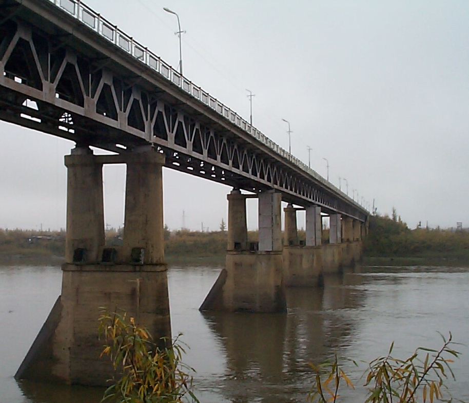
 The R504 Kolyma Highway (russian: Федеральная автомобильная дорога «Колыма», ''Federal'naya Avtomobil'naya Doroga «Kolyma»,'' "Federal Automobile Highway 'Kolyma'"), part of the M56 route, is a road through the
 Russian Far East
The Russian Far East (russian: Дальний Восток России, r=Dal'niy Vostok Rossii, p=ˈdalʲnʲɪj vɐˈstok rɐˈsʲiɪ) is a region in Northeast Asia. It is the easternmost part of Russia and the Asian continent; and is admin ...
. It connects Magadan with the town of Nizhny Bestyakh
Nizhny Bestyakh (russian: Ни́жний Бестя́х; sah, Аллараа Бэстээх) is an urban locality (an urban-type settlement) in Megino-Kangalassky District of the Sakha Republic, Russia, located on the east bank of the Lena Riv ...
, located on the eastern bank of Lena River, opposite of Yakutsk
Yakutsk (russian: Якутск, p=jɪˈkutsk; sah, Дьокуускай, translit=Djokuuskay, ) is the capital city of the Sakha Republic, Russia, located about south of the Arctic Circle. Fueled by the mining industry, Yakutsk has become one ...
. At Nizhny Bestyakh the Kolyma Highway connects to the Lena Highway.
The Kolyma Highway is colloquially known as the Road of Bones (Russian
Russian(s) refers to anything related to Russia, including:
*Russians (, ''russkiye''), an ethnic group of the East Slavic peoples, primarily living in Russia and neighboring countries
*Rossiyane (), Russian language term for all citizens and peo ...
: Дорога Костей, transliteration: ''Doróga Kostyéy''), in reference to the hundreds of thousands of forced laborers who were interred in the pavement after dying during its construction. Locally, the road is known as the Kolyma Route (Russian
Russian(s) refers to anything related to Russia, including:
*Russians (, ''russkiye''), an ethnic group of the East Slavic peoples, primarily living in Russia and neighboring countries
*Rossiyane (), Russian language term for all citizens and peo ...
: Колымская трасса, transliteration: ''Kolýmskaya trássa'').
History


 The
The Dalstroy
Dalstroy (russian: Дальстро́й, ), also known as Far North Construction Trust, was an organization set up in 1931 in order to manage road construction and the mining of gold in the Russian Far East, including the Magadan Region, Chukotka, ...
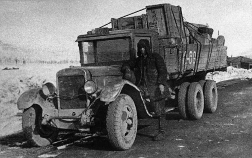
construction directorate built the Kolyma Highway during the Soviet Union
The Soviet Union,. officially the Union of Soviet Socialist Republics. (USSR),. was a List of former transcontinental countries#Since 1700, transcontinental country that spanned much of Eurasia from 1922 to 1991. A flagship communist state, ...
's Stalinist era
Stalinism is the means of governing and Marxist-Leninist policies implemented in the Soviet Union from 1927 to 1953 by Joseph Stalin. It included the creation of a one-party totalitarian police state, rapid industrialization, the theory o ...
. Inmates of the Sevvostlag
Sevvostlag (russian: Северо-восточные исправительно-трудовые лагеря, Севвостлаг, СВИТЛ, North-Eastern Corrective Labor Camps) was a system of forced labor camps set up to satisfy the wor ...
labour camp
A labor camp (or labour camp, see spelling differences) or work camp is a detention facility where inmates are forced to engage in penal labor as a form of punishment. Labor camps have many common aspects with slavery and with prisons (especi ...
started the first stretch in 1932, and construction continued with the use of gulag
The Gulag, an acronym for , , "chief administration of the camps". The original name given to the system of camps controlled by the GPU was the Main Administration of Corrective Labor Camps (, )., name=, group= was the government agency in ...
labour until 1953.
The road is treated as a memorial, as the bones of the estimated 250,0001,000,000 slave laborers and political prisoners who died while constructing it were laid beneath or around the road. As the road is built on permafrost, interment into the fabric of the road was deemed more practical than digging new holes to bury the bodies of the dead.
Present
In 2008, the road was granted Federal Road status, and is now a frequently maintained all-weather gravel road. When the road was upgraded, the route was changed to bypass the section fromKyubeme
Kyubeme (russian: Кюбеме; sah, Күбүмэ, ''Kübüme'') is a rural locality (a '' selo'') in Yuchyugeysky Rural Okrug of Oymyakonsky District in the Sakha Republic, Russia, located from Ust-Nera, the administrative center of the distr ...
to Kadykchan
Kadykchan (russian: Кадыкча́н) is a depopulated urban locality (a work settlement) in Susumansky District of Magadan Oblast, Russia. It is located in the Upper Kolyma Highlands, in the basin of the Ayan-Yuryakh River, northwest of ...
via Tomtor, and instead pass from Kyubeme to Kadykchan via a more northern route through the town of Ust-Nera
Ust-Nera ( rus, Усть-Нера, r=; sah, Уус Ньара, translit=Uus Nyara) is an urban locality (an urban-type settlement) and the administrative center of Oymyakonsky District in Yakutia, Russia. Located in one of the coldest permanent ...
. The old 420 km section via Tomtor was largely unmaintained; the 200 km section between Tomtor and Kadykchan was completely abandoned. This section is known as the Old Summer Road, and has fallen into disrepair, with washed-out bridges and sections of road reclaimed by streams in summer. During winter, frozen rivers may assist river crossings. Old Summer Road remains one of the great challenges for adventuring motorcyclists and 4WDers.
The area is extremely cold during the winter. The town of Oymyakon
Oymyakon, ; sah, Өймөкөөн, ''Öymököön'', is a rural locality (a '' selo'') in Oymyakonsky District of the Sakha Republic, Russia, located in the Yana-Oymyakon Highlands, along the Indigirka River, northwest of Tomtor on the Koly ...
, approximately 100 km from the highway, is believed to be the coldest inhabited place on earth. The average low temperature in Oymyakon in January is −50°C. In 2020, a teenage motorist froze to death by following Google Maps
Google Maps is a web mapping platform and consumer application offered by Google. It offers satellite imagery, aerial photography, street maps, 360° interactive panoramic views of streets ( Street View), real-time traffic conditions, and rou ...
directions to use the shorter but abandoned section of the road via Tomtor, on which his car broke down, and his surviving travel mate lost most of his limbs due to frostbite
Frostbite is a skin injury that occurs when exposed to extreme low temperatures, causing the freezing of the skin or other tissues, commonly affecting the fingers, toes, nose, ears, cheeks and chin areas. Most often, frostbite occurs in the ha ...
.
Route
There is also a scenic shortcut from Magadan to Susuman via Ust-Omchug called the ''Tenkinskaya Trassa'', which receives a lot less heavy traffic than the main section of the M56 between Magadan and Susuman. Distances: Yakutsk to Khandyga , on to Kyubeme , to Kadykchan (via Tomtor) , Kadykchan to Susuman , Susuman to Magadan . From Kyubeme to Kadykchan north via Ust-Nera (the new, maintained section) is about . As of summer 2010, the Old Summer Road via Tomtor was still passable to motorcycles and 4×4s.Road to Chukotka
The Anadyr Highway from the Kolyma Highway toAnadyr Anadyr may refer to:
*Anadyr (town), a town and the administrative center of Chukotka Autonomous Okrug, Russia
*Anadyr District
*Anadyr Estuary
*Anadyr (river), a river in Chukotka Autonomous Okrug, Russia
*Anadyr Highlands
*Anadyr Lowlands
*Operati ...
in Chukotka passes Omsukchan
Omsukchan (russian: Омсукча́н) is an urban locality (an urban-type settlement) and the administrative center of Omsukchansky District of Magadan Oblast, Russia, located north of Magadan. Population:
History
Omsukchan was founded in ...
, Omolon
The Omolon (russian: Омолон; sah, Омолоон) is the principal tributary of the Kolyma in northeast Siberia. The length of the river is . The area of its basin is . The Omolon freezes up in October and stays under ice until late May t ...
, and Ilirney with branch roads to Bilibino
Bilibino (russian: Били́бино) is a town and the administrative center of Bilibinsky District in Chukotka Autonomous Okrug, Russia. It is located northwest of Anadyr, the administrative center of the autonomous okrug. It is the second l ...
and Egvekinot
Egvekinot (russian: Эгвекино́т; Chukchi: , ''Èrvyḳynnot'', lit. ''sharp, hard land'')Fute, p. 125 is an urban locality (an urban-type settlement) and the administrative center of Iultinsky District in Chukotka Autonomous Okrug ...
, involving construction of of road./ref> The construction of the first 50 kilometers of the road started in 2012.
See also
*Gulag
The Gulag, an acronym for , , "chief administration of the camps". The original name given to the system of camps controlled by the GPU was the Main Administration of Corrective Labor Camps (, )., name=, group= was the government agency in ...
*Amur Cart Road
The Amur Cart Road or Amur Wheel Road (russian: Аму́рская колёсная доро́га or , tr. ) was a cartage road in Amur Oblast of Imperial Russia that connected Khabarovsk with Blagoveshchensk through mostly uninhabited areas of ...
*Dempster Highway
The Dempster Highway, also referred to as Yukon Highway 5 and Northwest Territories Highway 8, is a highway in Canada that connects the Klondike Highway in Yukon to Inuvik, Northwest Territories on the Mackenzie River delta. The highway crosses ...
a similar highway in Canada
Notes
References
* Bloom, L. R. and Vince, A. E. (2006) ''Mondo enduro: the ultimate adventure on two wheels – 44,000 miles in 400 days'', Findon: RippingYarns.com, * McGregor, E., Boorman, C. and Uhlig R. (2005) ''Long way round : chasing shadows across the world'', London : Time Warner, * Pedersen, H., Payne, D. and Squire, S. (1998) ''10 Years on 2 Wheels: 77 Countries, 250,000 Miles'', Elfin Cove Press, * Scott, A. (2008)The Road Gets Better From Here
', Vivid Publishing, * The Long Course route and GPS trac
* Thompson, G. (2002
''Kolyma – The Road of Death''
The Mission Reporter, Florida : Dundee,
www
The World Wide Web (WWW), commonly known as the Web, is an information system enabling documents and other web resources to be accessed over the Internet.
Documents and downloadable media are made available to the network through web se ...
site ccessed 21 May 2007Turtle Expedition
AskYakutia.com : Road condition reports
External links
made
documentary
of Gulag camp of Kolyma. * Documentary ''*** GOLD*** - lost in Siberia'
was filmed in the summer of 1993 in Magadan, and along the ''Road of Bones'', through Ust-Omchug and Susuman to the Sverovostok Zoloto gold mine,
Siberia
Siberia ( ; rus, Сибирь, r=Sibir', p=sʲɪˈbʲirʲ, a=Ru-Сибирь.ogg) is an extensive region, geographical region, constituting all of North Asia, from the Ural Mountains in the west to the Pacific Ocean in the east. It has been a ...
, by the first foreign film crew ever, visiting the Kolyma District -which had been under control of the Soviet secret service, under the company name Dalstroj, for over 60 years.
{{coord missing, Magadan Oblast, Sakha Republic
Roads in Siberia
Roads in the Russian Far East
Transport in the Sakha Republic
Transport in Magadan Oblast
Gulag industry
Magadan