Dampier Peninsula on:
[Wikipedia]
[Google]
[Amazon]
 The Dampier Peninsula is a
 The peninsula is home to a rich heritage of Aboriginal culture, with the communities of Beagle Bay, Bobieding,
Shire of Broome
Broome Visitor Centre
{{coord, -17.21, 122.81, dim:200000_region:AU, display=title Kimberley (Western Australia) Coastline of Western Australia Peninsulas of Western Australia Kimberley tropical savanna
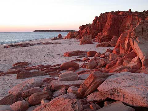
 The Dampier Peninsula is a
 peninsula
A peninsula (; ) is a landform that extends from a mainland and is surrounded by water on most, but not all of its borders. A peninsula is also sometimes defined as a piece of land bordered by water on three of its sides. Peninsulas exist on all ...
located north of Broome and Roebuck Bay
Roebuck Bay is a bay on the coast of the Kimberley region of Western Australia. Its entrance is bounded in the north by the town of Broome, and in the south by Bush Point and Sandy Point. It is named after , the ship captained by William ...
in Western Australia
Western Australia (commonly abbreviated as WA) is a state of Australia occupying the western percent of the land area of Australia excluding external territories. It is bounded by the Indian Ocean to the north and west, the Southern Ocean to th ...
. It is surrounded by the Indian Ocean
The Indian Ocean is the third-largest of the world's five oceanic divisions, covering or ~19.8% of the water on Earth's surface. It is bounded by Asia to the north, Africa to the west and Australia to the east. To the south it is bounded by th ...
to the west and north, and King Sound
King Sound is a large gulf in northern Western Australia. It expands from the mouth of the Fitzroy River, one of Australia's largest watercourses, and opens to the Indian Ocean. It is about long, and averages about in width. The port town ...
to the east. It is named after the mariner and explorer William Dampier
William Dampier (baptised 5 September 1651; died March 1715) was an English explorer, pirate, privateer, navigator, and naturalist who became the first Englishman to explore parts of what is today Australia, and the first person to circumnav ...
who visited it. The northernmost part of the peninsula is Cape Leveque
Cape Leveque is at the northernmost tip of the Dampier Peninsula in the Kimberley region of Western Australia. Cape Leveque is (via the Cape Leveque Road) north of Broome, and is remote with few facilities. Nevertheless, the Cape's sandy bea ...
. It is sparsely inhabited, mostly by Indigenous Australian
Indigenous Australians or Australian First Nations are people with familial heritage from, and membership in, the ethnic groups that lived in Australia before British colonisation. They consist of two distinct groups: the Aboriginal peoples ...
peoples, some of whom have been granted native title
Aboriginal title is a common law doctrine that the land rights of indigenous peoples to customary tenure persist after the assumption of sovereignty under settler colonialism. The requirements of proof for the recognition of aboriginal title, ...
rights to some of their traditional lands. There are many coastal inlets, bays and other features, including Beagle Bay on its western side.
Aboriginal heritage
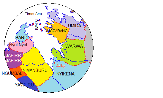
 The peninsula is home to a rich heritage of Aboriginal culture, with the communities of Beagle Bay, Bobieding,
 Djarindjin
Djarindjin is a medium-sized Aboriginal community located north of Broome in the Kimberley region of Western Australia, within the Shire of Broome. It is within the traditional lands of the Bardi and Jawi peoples.
Location
Djarindjin is l ...
, Ardyaloon (One Arm Point) and Ngardalargin, along with numerous other smaller communities, pearling camps, tourist resorts and Aboriginal outstations.
The traditional owner
Native title is the designation given to the common law doctrine of Aboriginal title in Australia, which is the recognition by Australian law that Indigenous Australians (both Aboriginal Australian and Torres Strait Islander people) have rights ...
s of the areas around the peninsula are the Bardi, Nyunyul and Jabirr Jabirr (Djaberadjabera) peoples.
Ecology
Many small trees, shrubs and animals live on and in the sea surrounding the peninsula, the most characteristic vegetation beingpindan
Pindan is a name given to the red-soil country of the south-western Kimberley region of Western Australia. The term comes from a local language and applies both to the soil and to the vegetation community associated with it.Lowe (2003).
History ...
woodland
A woodland () is, in the broad sense, land covered with trees, or in a narrow sense, synonymous with wood (or in the U.S., the ''plurale tantum'' woods), a low-density forest forming open habitats with plenty of sunlight and limited shade (see ...
within the interior sandplains.
Mangroves are an important part within the peninsula, with 12 of Western Australia's 17 species present. Flying Fox colonies commonly roost in the trees during the day before foraging at dusk.https://library.dbca.wa.gov.au/static/FullTextFiles/016991.pdf
page 31 and 39.
Transport
The peninsula is traversed from south to north by Cape Leveque Road. Between Broome and Beagle Bay this road is generally of poor condition and often closed during the wet season. Four-wheel drive is recommended. Between Beagle Bay and the northern towns the road is bitumened. Numerous tour operators run bus services on the peninsula. Air strips are situated at Cape Leveque, Bardi, Djarindjin (Lombadina), Beagle Bay and some of the smaller communities and pearl farms.Tourism
There are several tourist accommodation facilities such as Kooljamon (Cape Leveque) and Middle Lagoon (Middle Lagoon).References
External links
Shire of Broome
Broome Visitor Centre
{{coord, -17.21, 122.81, dim:200000_region:AU, display=title Kimberley (Western Australia) Coastline of Western Australia Peninsulas of Western Australia Kimberley tropical savanna