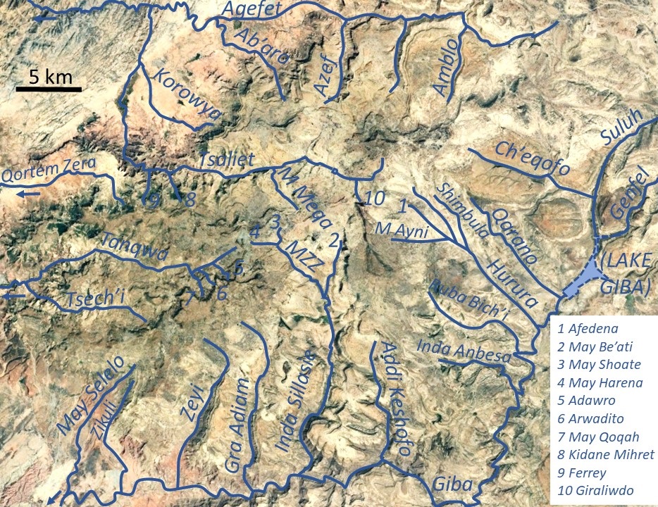
Agefet Downstream on:
[Wikipedia]
[Google]
[Amazon]
Agefet is a river of the Nile basin. Rising in the mountains of Gheralta in northern Ethiopia, it flows westward to empty finally in Weri’i and 
 It is a confined ephemeral river, locally meandering in its narrow alluvial plain, with an average slope gradient of 13 metres per kilometre. At the end of its course, it occupies a sandy pediment.
Tekezé River
The Tekezé or Täkkäze River ( amh, ተከዜ, ti, ተከዘ; originally meaning "river" in Ge’ez, ), also spelled Takkaze, is a major river of Ethiopia. For part of its course it forms a section of the westernmost border of Ethiopia and Erit ...
.

Characteristics
 It is a confined ephemeral river, locally meandering in its narrow alluvial plain, with an average slope gradient of 13 metres per kilometre. At the end of its course, it occupies a sandy pediment.
Flash floods and flood buffering
Runoff mostly happens in the form of high runoff discharge events that occur in a very short period (called flash floods). These are related to the steep topography, often little vegetation cover and intense convective rainfall. The peaks of such flash floods have often a 50 to 100 times larger discharge than the preceding baseflow. The magnitude of floods in this river has however been decreased due to interventions in the catchment. Physical conservation structures such as stone bunds andcheck dam
A steel check dam
A check dam is a small, sometimes temporary, dam constructed across a swale, drainage ditch, or waterway to counteract erosion by reducing water flow velocity. Check dams themselves are not a type of new technology; rather, the ...
s intercept runoff. On many steep slopes, exclosures have been established; the dense vegetation largely contributes to enhanced infiltration
Infiltration may refer to:
Science, medicine, and engineering
*Infiltration (hydrology), downward movement of water into soil
*Infiltration (HVAC), a heating, ventilation, and air conditioning term for air leakage into buildings
*Infiltration (me ...
, less flooding and better baseflow.
Transhumance towards the gorge
Transhumance takes place in the summer rainy season, when the lands near the villages are occupied by crops. Young shepherds will take the village cattle down to the Agefet gorge. The gorges are particularly attractive as a transhumance destination zone, because there is water and good growth of semi-natural vegetation.Boulders and pebbles in the river bed
From upstream to downstream, the following lithological units occur in the catchment. *Phonolite
Phonolite is an uncommon extrusive rock, of intermediate chemical composition between felsic and mafic, with texture ranging from aphanitic (fine-grained) to porphyritic (mixed fine- and coarse-grained). Phonolite is a variation of the igneous ...
plugs
* Upper basalt
* Interbedded lacustrine deposits
* Lower basalt
* Amba Aradam Formation
The Amba Aradam Formation is a Cretaceous sandstone formation in Ethiopia. It is up to 200 metres thick, for instance in the Degua Tembien district. As fossils are absent, the age of the Amba Aradam Formation was interpreted based on the age of a ...
* Antalo Limestone
* Quaternary
The Quaternary ( ) is the current and most recent of the three periods of the Cenozoic Era in the geologic time scale of the International Commission on Stratigraphy (ICS). It follows the Neogene Period and spans from 2.58 million years ...
freshwater tufa
* Adigrat Sandstone
* Edaga Arbi Glacials
Logically, in the uppermost stretches of the river, only the pebbles and boulders of the upper lithological units will be present in the river bed, whereas more downstream one may find a more comprehensive mix of all lithologies crossed by the river.
Natural boundary
During its course, this river passes through three woredas (Kola Tembien
Kola Tembien (, "Lower Tembien") is a woreda in Tigray Region, Ethiopia. It is named in part after the former province of Tembien. Part of the Mehakelegnaw Zone, Kola Tembien is bordered on the south by Abergele, on the west by the Tekezé River ...
, Dogu’a Tembien
Dogu'a Tembien (, "Upper Tembien", sometimes transliterated as Degua Tembien) is a woreda in Tigray Region, Ethiopia. It is named in part after the former province of Tembien. Nowadays, the mountainous district is part of the Southeastern Tigray ...
and Kilte Awula’ilo) and constitutes the border between the two latter over a dozen of kilometres.
Trekking along the river
Trekking routes have been established across and along this river. The tracks are not marked on the ground but can be followed using downloaded .GPX files. * Trek Gh1, follows the river in its eastern course * Trek Gh2, crosses the river in its western course In the rainy season, flash floods may occur and it is advised not to follow the river bed. Generally, it is impossible to cross the river in the rainy season.See also
* List of Ethiopian riversReferences
{{reflist Rivers of Ethiopia Dogu'a Tembien Tigray Region Nile basin