|
Tectonostratigraphic Terrane
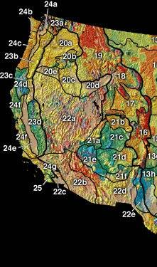
In geology, a terrane (; in full, a tectonostratigraphic terrane) is a crust fragment formed on a tectonic plate (or broken off from it) and accreted or " sutured" to crust lying on another plate. The crustal block or fragment preserves its own distinctive geologic history, which is different from that of the surrounding areas—hence the term "exotic" terrane. The suture zone between a terrane and the crust it attaches to is usually identifiable as a fault. A sedimentary deposit that buries the contact of the terrane with adjacent rock is called an overlap formation. An igneous intrusion that has intruded and obscured the contact of a terrane with adjacent rock is called a stitching pluton. Older usage of ''terrane'' simply described a series of related rock formations or an area having a preponderance of a particular rock or rock groups. Overview A tectonostratigraphic terrane is not necessarily an independent microplate in origin, since it may not contain the full thickness ... [...More Info...] [...Related Items...] OR: [Wikipedia] [Google] [Baidu] |
Geology
Geology () is a branch of natural science concerned with Earth and other astronomical objects, the features or rocks of which it is composed, and the processes by which they change over time. Modern geology significantly overlaps all other Earth sciences, including hydrology, and so is treated as one major aspect of integrated Earth system science and planetary science. Geology describes the structure of the Earth on and beneath its surface, and the processes that have shaped that structure. It also provides tools to determine the relative and absolute ages of rocks found in a given location, and also to describe the histories of those rocks. By combining these tools, geologists are able to chronicle the geological history of the Earth as a whole, and also to demonstrate the age of the Earth. Geology provides the primary evidence for plate tectonics, the evolutionary history of life, and the Earth's past climates. Geologists broadly study the properties and processes of E ... [...More Info...] [...Related Items...] OR: [Wikipedia] [Google] [Baidu] |
Pacific Cordillera
The North American Cordillera, sometimes also called the Western Cordillera of North America, the Western Cordillera or the Pacific Cordillera, is the North American portion of the American Cordillera, the mountain chain system (cordillera) along the western coast (Pacific coast) of the Americas. The North American Cordillera covers an extensive area of mountain ranges, intermontane basins and plateaus in Western/ Northwestern Canada, Western United States and Mexico, including much of the territory west of the Great Plains. The precise boundaries of this cordillera and its subregions, as well as the names of its various features, may differ depending on the definitions in each country or jurisdiction, and also depending on the scientific field; this cordillera is a particularly prominent subject in the scientific field of physical geography.Melanie Ostopowich (2005) The Cordillera', Weigl Educational Publishers Limited, , pp. 6, 12, and 20: "The Cordillera is one of the seven g ... [...More Info...] [...Related Items...] OR: [Wikipedia] [Google] [Baidu] |
Aldan Terrane
Aldan may refer to: ;People *Gille Aldan, the first bishop of Galloway, Scotland *Andrey Aldan-Semenov (1908–1985), Russian writer *Duke Aldan, a fictional character in ''Langrisser IV'' video game ;Places *Aldan, Russia, a town in the Sakha Republic, Russia *Aldan Urban Settlement, a municipal formation which the Town of Aldan and two rural localities in Aldansky District of the Sakha Republic, Russia are incorporated as *Aldan, Pennsylvania, a borough in Pennsylvania, United States *Aldan Highlands in the Sakha Republic, Russia *Aldan (river), a river in the Sakha Republic, Russia *Aldan Shield, a geological region in Siberia, Russia *Aldan Airport, an airport in the Sakha Republic, Russia *Aldan mine, an iron mine in the Sakha Republic, Russia See also *Alden (other) * Clifton–Aldan (SEPTA station), a SEPTA station in Clifton Heights, Pennsylvania, United States *Aldansky District Aldansky District (russian: Алда́нский улу́с; sah, Алдан ул ... [...More Info...] [...Related Items...] OR: [Wikipedia] [Google] [Baidu] |
Mozambique Belt
The Mozambique Belt is a band in the earth's crust that extends from East Antarctica through East Africa up to the Arabian-Nubian Shield. It formed as a suture between plates during the Pan-African orogeny, when Gondwana was formed. The Mozambique Belt includes components created when the Mozambique Ocean opened and others created when the ocean later closed. Extent The western portion of the Mozambique Belt is mostly composed of upper amphibolite-grade gneisses, reworked rocks from the Tanzania craton and Usagaran Belt, emplaced between 2,970 and 2,648 million years ago. The eastern portion has high-grade arc-derived rocks ranging in age from 841 to 632 million years ago. Both terranes also include Neoproterozoic metasedimentary rocks. The differences may indicate origins in two different basins, with the eastern basin rocks being thrust over those of the western basin during closure of the Mozambique Ocean between 585 and 550 million years ago. Formation Many geologist ... [...More Info...] [...Related Items...] OR: [Wikipedia] [Google] [Baidu] |
Likasi Terrane
Likasi (formerly official names: Jadotville (French) and Jadotstad (Dutch)) is a city in Haut-Katanga Province, in the south-east of the Democratic Republic of Congo. Demographics Likasi has a population of around 635,000 (2015). During the 1990s the United Nations set up feeding centres and refugee centres in and around Likasi to assist with the refugees fleeing ethnic violence in Shaba, whose arrival had increased the population of the town some 41,000. History Shinkolobwe mine, 20 km west of Likasi (then called Jadotville), was described by a 1943 Manhattan Project intelligence report as the most important deposit of uranium yet discovered in the world. The uranium from this mine was used to build the atomic bombs used in Hiroshima and Nagasaki in 1945. In 1961, during the United Nations intervention in the Katanga conflict, a company of Irish UN troops deployed to Jadotville was besieged and eventually surrendered to troops loyal to the Katangese Prime Minister Moïs ... [...More Info...] [...Related Items...] OR: [Wikipedia] [Google] [Baidu] |
University Of British Columbia
The University of British Columbia (UBC) is a public university, public research university with campuses near Vancouver and in Kelowna, British Columbia. Established in 1908, it is British Columbia's oldest university. The university ranks among the top three universities in Canada. With an annual research budget of $759million, UBC funds over 8,000 projects a year. The Vancouver campus is situated adjacent to the University Endowment Lands located about west of downtown Vancouver. UBC is home to TRIUMF, Canada's national laboratory for Particle physics, particle and nuclear physics, which houses the world's largest cyclotron. In addition to the Peter Wall Institute for Advanced Studies and Stuart Blusson Quantum Matter Institute, UBC and the Max Planck Society collectively established the first Max Planck Institute in North America, specializing in quantum materials. One of the largest research libraries in Canada, the UBC Library system has over 9.9million volumes among it ... [...More Info...] [...Related Items...] OR: [Wikipedia] [Google] [Baidu] |
Paleomagnetism
Paleomagnetism (or palaeomagnetismsee ), is the study of magnetic fields recorded in rocks, sediment, or archeological materials. Geophysicists who specialize in paleomagnetism are called ''paleomagnetists.'' Certain magnetic minerals in rocks can record the direction and intensity of Earth's magnetic field at the time they formed. This record provides information on the past behavior of the geomagnetic field and the past location of tectonic plates. The record of geomagnetic reversals preserved in volcanic and sedimentary rock sequences (magnetostratigraphy) provides a time-scale that is used as a geochronologic tool. Evidence from paleomagnetism led to the revival of the continental drift hypothesis and its transformation into the modern theory of plate tectonics. Apparent polar wander paths provided the first clear geophysical evidence for continental drift, while marine magnetic anomaly, magnetic anomalies did the same for seafloor spreading. Paleomagnetic data continues t ... [...More Info...] [...Related Items...] OR: [Wikipedia] [Google] [Baidu] |
Biodiversity
Biodiversity or biological diversity is the variety and variability of life on Earth. Biodiversity is a measure of variation at the genetic (''genetic variability''), species (''species diversity''), and ecosystem (''ecosystem diversity'') level. Biodiversity is not distributed evenly on Earth; it is usually greater in the tropics as a result of the warm climate and high primary productivity in the region near the equator. Tropical forest ecosystems cover less than 10% of earth's surface and contain about 90% of the world's species. Marine biodiversity is usually higher along coasts in the Western Pacific, where sea surface temperature is highest, and in the mid-latitudinal band in all oceans. There are latitudinal gradients in species diversity. Biodiversity generally tends to cluster in hotspots, and has been increasing through time, but will be likely to slow in the future as a primary result of deforestation. It encompasses the evolutionary, ecological, and cultural ... [...More Info...] [...Related Items...] OR: [Wikipedia] [Google] [Baidu] |
Geology Of The Appalachians
The geology of the Appalachians dates back to more than 480 million years ago. A look at rocks exposed in today's Appalachian Mountains reveals elongate belts of folded and thrust faulted marine sedimentary rocks, volcanic rocks and slivers of ancient ocean floor – strong evidence that these rocks were deformed during plate collision. The birth of the Appalachian ranges marks the first of several mountain building plate collisions that culminated in the construction of the supercontinent Pangaea with the Appalachians and neighboring Anti-Atlas mountains (now in Morocco) near the center. These mountain ranges likely once reached elevations similar to those of the Alps and the Rocky Mountains before they were eroded. Geological history Paleozoic Era During the earliest part of the Paleozoic Era, the continent that would later become North America straddled the equator. The Appalachian region was a passive plate margin, not unlike today's Atlantic Coastal Plain Province. ... [...More Info...] [...Related Items...] OR: [Wikipedia] [Google] [Baidu] |
Pacific
The Pacific Ocean is the largest and deepest of Earth's five oceanic divisions. It extends from the Arctic Ocean in the north to the Southern Ocean (or, depending on definition, to Antarctica) in the south, and is bounded by the continents of Asia and Oceania in the west and the Americas in the east. At in area (as defined with a southern Antarctic border), this largest division of the World Ocean—and, in turn, the hydrosphere—covers about 46% of Earth's water surface and about 32% of its total surface area, larger than Earth's entire land area combined .Pacific Ocean . '' Britannica Concise.'' 2008: Encyclopædia Britannica, Inc. The centers of both the |


.gif)

.jpg)