|
Regions Of Chad
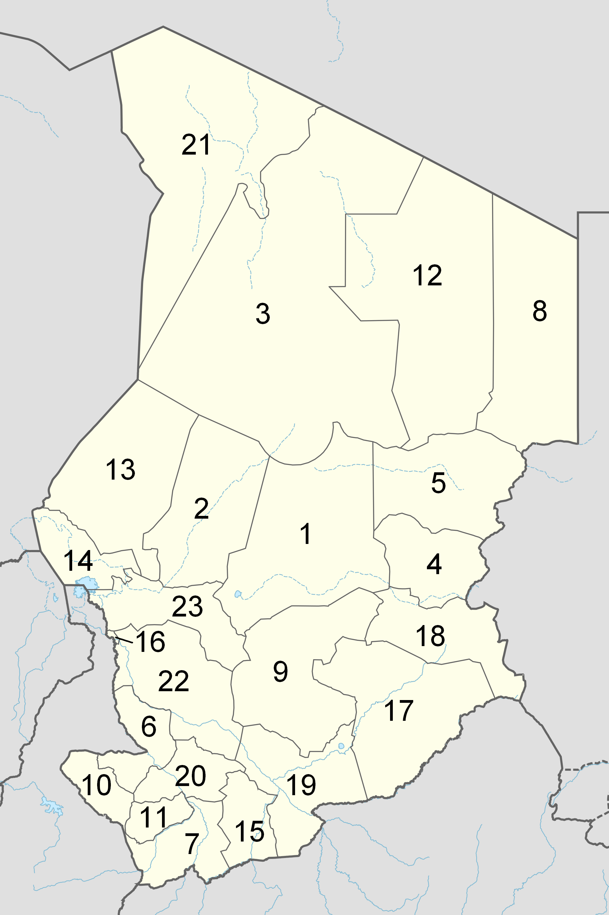
The Republic of Chad is made up of twenty-three regions. Chad was divided into regions in 2002. It was previously divided into prefectures, and then departments. Current regions This is a list of the regions of Chad since 2012, with population figures from the 2009 census. History From independence in 1960 until 1999 it was divided into 14 ''préfectures''. These were replaced in 1999 by 28 ''départements''. The country was reorganized again in 2002 to produce 18 ''régions''. In 2008, a further four ''régions'' were created, increasing the number to 22. Ennedi Region was split into Ennedi-Est and Ennedi-Ouest in 2012, producing the current 23 regions. Regions (2008–2012) Regions (2002–2008) (1) created in 2004 Regions created in 2008 On February 19, 2008, four new regions were created: * Former Borkou-Ennedi-Tibesti Region divided into: ** Borkou Region, from Borkou-Ennedi-Tibesti's former Borkou Department ** Ennedi Region, from Borkou-Ennedi-Ti ... [...More Info...] [...Related Items...] OR: [Wikipedia] [Google] [Baidu] |
Republic Of Chad
Chad (; ar, تشاد , ; french: Tchad, ), officially the Republic of Chad, '; ) is a landlocked country at the crossroads of North and Central Africa. It is bordered by Libya to the north, Sudan to the east, the Central African Republic to the south, Cameroon to the southwest, Nigeria to the southwest (at Lake Chad), and Niger to the west. Chad has a population of 16 million, of which 1.6 million live in the capital and largest city of N'Djamena. Chad has several regions: a desert zone in the north, an arid Sahelian belt in the centre and a more fertile Sudanian Savanna zone in the south. Lake Chad, after which the country is named, is the second-largest wetland in Africa. Chad's official languages are Arabic and French. It is home to over 200 different ethnic and linguistic groups. Islam (55.1%) and Christianity (41.1%) are the main religions practiced in Chad. Beginning in the 7th millennium BC, human populations moved into the Chadian basin in great numbers. By t ... [...More Info...] [...Related Items...] OR: [Wikipedia] [Google] [Baidu] |
Massakory
Massakory ( ar, ماساكوري) is the capital of the Chadian region of Hadjer-Lamis and of the department of Dagana. The town was formerly in the prefecture of Fort-Lamy in the department of Bas-Chari. People The territory around Massakory used to be ruled by the sultan of Ouaddaï. Two tribes dominate this region: the Dagana, nomadic herders, in the interior and the Kouri Kalé on the shores and islands of the western part of the lake. The Bulala, who live near Massagory, are said to be Arab in origin. They helped to found the Kanem kingdom, and helped to expel the Kanem royal family in the 13th century. They were later forced to move to the Yao region where they created a small Sultanate and settled into an agricultural lifestyle, although they are said to be good warriors. The French colonialists created the post of Massakory in the Dagana territory in 1901. In 1925 the Bas-Chari region supplied 1,500 workers to work on the Congo-Ocean railway line. During the French ... [...More Info...] [...Related Items...] OR: [Wikipedia] [Google] [Baidu] |
Borkou (region Of Chad)
The Borkou region ( ar, بركو) is a region of Chad which was created in 2008 from the Borkou department of the former Borkou-Ennedi-Tibesti region. Its capital is Faya-Largeau. Geography Borkou is located in the Sahara Desert, and contains parts of the Tibesti Mountains in its north. The highest point in Chad, Emi Koussi, is located in Borkou. The Bodélé Depression lies in the south-central portion of the region. The region borders Libya to the north, Ennedi-Ouest Region to the east, Wadi Fira Region, Batha Region, Bahr el Gazel Region and Kanem Region to the south, and Niger and Tibesti Region the west. The region's northern border lies within the Aouzou Strip, historically a point of dispute between Chad and Libya.Geoffrey Leslie Simons, ''Libya and the West: from independence to Lockerbie'', Centre for Libyan Studies (Oxford, England). Pg. 57 Settlements Faya-Largeau is the regional capital; other major settlements include Gouro, Kirdimi, Koro Toro and Yarda. Demog ... [...More Info...] [...Related Items...] OR: [Wikipedia] [Google] [Baidu] |
Barh El Gazel Nord
Barh El Gazel Nord is one of two departments of Chad in Barh El Gazel, a region of Chad. Its capital is Salal ''Gaultheria shallon'' is an evergreen shrub in the heather family (Ericaceae), native to western North America. In English, it is known as salal, shallon, or (mainly in Britain) gaultheria. Description ''Gaultheria shallon'' is tall, spra .... Departments of Chad Bahr el Gazel Region {{Chad-geo-stub ... [...More Info...] [...Related Items...] OR: [Wikipedia] [Google] [Baidu] |
Moussoro
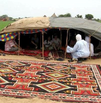
Moussoro ( ar, موسورو) is a town in Chad, lying northeast of N'Djamena on the road to Faya-Largeau. An important transportation centre, it lies in a dry river bed and as a result has more vegetation than is typical in the area. Moussoro is the capital of the region of Barh El Gazel (Bahr el Gazel). The town is served by Moussoro Airport. Moussoro is inhabited by Gouran (Krreda)(Karra) ethnic group of northern Chad. It serves as their commercial and administrative town. Moussoro market day is Thursday. They mostly known by their agricultural activity. Moussoro have the second president's residence in Chad after the main Residence in N'djamena (''see image below''). The town is also the main area for army training in Chad. Gallery File:BEG moussoro2.jpg, Nomadic tent near Moussoro (2012 photograph) File:Making Tea.jpg, Man pouring tea (2015) File:Camel Market.jpg, Weekly camel market (March 2011) References {{reflist , refs = {{cite web , url = http://www.estis.n ... [...More Info...] [...Related Items...] OR: [Wikipedia] [Google] [Baidu] |
Bahr El Gazel (region Of Chad)
Barh El Gazel ( ar, منطقة بحر الغزال, french: Région du Barh El Gazel) is one of the 23 regions of Chad. The region's name may also be written as Barh El Gazal or Bahr el Gazel. Its capital is the town of Moussoro. The region was created in 2008 from the former Barh El Gazel Department of the Kanem Region. Geography The region borders Borkou Region to the north, Batha Region to the east, Hadjer-Lamis Region to the south, and Kanem Region to the west. The region is predominantly grassland, merging into the Sahara Desert in the north. Settlements Moussoro is the regional capital; other major settlements include Chadra, Dourgoulanga, Michemiré and Salal. Demographics As per the census of 2009, the population of the region was 260,865, 46.3% female. The average size of household as of 2009 is 5.90: 5.90 in rural households and 5.80 in urban areas. The total number of households was 43,478: 38,160 in rural areas and 5,318 in urban areas. The number of nomads in ... [...More Info...] [...Related Items...] OR: [Wikipedia] [Google] [Baidu] |
Kobé
Kobé ( ar, كوبي) is one of three departments in Wadi Fira, a region In geography, regions, otherwise referred to as zones, lands or territories, are areas that are broadly divided by physical characteristics ( physical geography), human impact characteristics ( human geography), and the interaction of humanity an ... of Chad. Its capital is Iriba. Departments of Chad {{Chad-geo-stub ... [...More Info...] [...Related Items...] OR: [Wikipedia] [Google] [Baidu] |
Dar Tama
Dar Tama ( ar, دار تاما) is one of three departments in Wadi Fira, a region of Chad. Its capital is Gueréda, northeast of Abéché. The population consists primarily of non-Arab tribes. Dar Tama is the historical home of the Tama, who make up the majority of the population. The Zaghawa make up a significant minority and migrated during the Sahelian drought in the 1980s. Both are non-Arab tribes. Chadian president Idriss Déby Idriss Déby Itno ' (18 June 1952 – 20 April 2021) was a Chadian politician and military officer who was the president of Chad from 1990 until his death in 2021. Déby was a member of the Bidayat clan of the Zaghawa ethnic group. A high-ranki ... is from the Zaghawa tribe. Sub-prefectures Loug Chari is divided into four sub-prefectures: * Guéréda * Kolonga * Sirim Birké (Serim Birké) References Departments of Chad Wadi Fira Region {{Chad-geo-stub ... [...More Info...] [...Related Items...] OR: [Wikipedia] [Google] [Baidu] |
Biltine Department
Biltine ( ar, بيلتين) is one of three departments in Wadi Fira, a region of Chad. Its capital is Biltine. Sub-prefectures Biltine is divided into four sub-prefectures: * Biltine * Am Zoer *Arada * Mata See also * Regions of Chad The Republic of Chad is made up of twenty-three regions. Chad was divided into regions in 2002. It was previously divided into prefectures, and then departments. Current regions This is a list of the regions of Chad since 2012, with population ... References Departments of Chad Wadi Fira Region {{Chad-geo-stub ... [...More Info...] [...Related Items...] OR: [Wikipedia] [Google] [Baidu] |
Biltine, Chad
Biltine (Arabic: بلتن) is a city in Chad, and the capital of Wadi Fira region (previously Biltine prefecture). The town was briefly captured on November 25, 2006, by the RADF, a rebel group, then recaptured the next day by the government, along with nearby Abéché that had been captured by a different rebel group, the UFDD The Union of Forces for Democracy and Development is the largest group of Chadian rebel forces opposed to former President Idriss Déby. It was formed in October 2006 under the leadership of Mahamat Nouri. The group consists of: * United Front f .... On June 16, 2008, the town was the scene of a battle between rebels on government forces, with the rebels said to have won. The town is served by Biltine Airport. Demographics References Wadi Fira Region Populated places in Chad {{Chad-geo-stub ... [...More Info...] [...Related Items...] OR: [Wikipedia] [Google] [Baidu] |
Wadi Fira (region)
Wadi Fira ( ar, وادي فيرا) is one of the 23 regions of Chad. Its capital is the town of Biltine. The region corresponds with the former prefecture of Biltine. Geography The region borders Borkou Region, Ennedi-Ouest Region and Ennedi-Est Region to the north, Sudan to the east, Ouaddaï Region to the south, and Batha Region to the west. The terrain is savannah merging into the Sahara Desert in the north, and rising to the east. Settlements Biltine is the region's capital; other major settlements include Guéréda, Iriba and Matadjana. Demographics As per the 2009 Chadian census, Wadi Fira's population is 508,383. The main ethnolinguistic groups are the Amdang, Baggara (generally speakers of Chadian Arabic), Maba, Mararit, Tama and Zaghawa. Subdivisions The region of Wadi Fira is divided into three departments, each listed with the name of its capital or main town (''chef-lieu An administrative center is a seat of regional administration or lo ... [...More Info...] [...Related Items...] OR: [Wikipedia] [Google] [Baidu] |

