|
Bahr El Gazel (region Of Chad)
Barh El Gazel ( ar, منطقة بحر الغزال, french: Région du Barh El Gazel) is one of the 23 regions of Chad. The region's name may also be written as Barh El Gazal or Bahr el Gazel. Its capital is the town of Moussoro. The region was created in 2008 from the former Barh El Gazel Department of the Kanem Region. Geography The region borders Borkou Region to the north, Batha Region to the east, Hadjer-Lamis Region to the south, and Kanem Region to the west. The region is predominantly grassland, merging into the Sahara Desert in the north. Settlements Moussoro is the regional capital; other major settlements include Chadra, Dourgoulanga, Michemiré and Salal. Demographics As per the census of 2009, the population of the region was 260,865, 46.3% female. The average size of household as of 2009 is 5.90: 5.90 in rural households and 5.80 in urban areas. The total number of households was 43,478: 38,160 in rural areas and 5,318 in urban areas. The number of nomads in ... [...More Info...] [...Related Items...] OR: [Wikipedia] [Google] [Baidu] |
Regions Of Chad
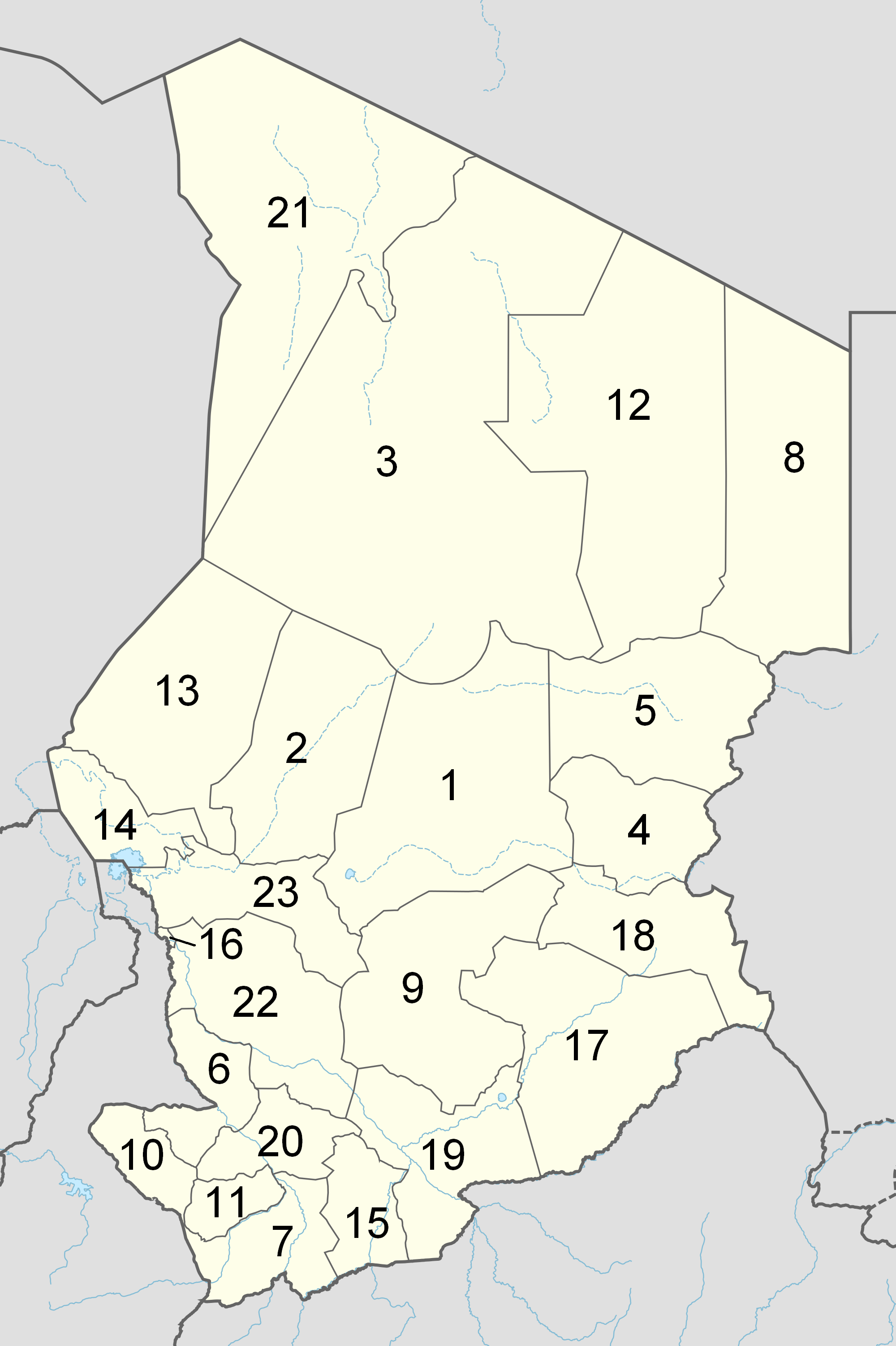
The Republic of Chad is made up of twenty-three regions. Chad was divided into regions in 2002. It was previously divided into prefectures, and then departments. Current regions This is a list of the regions of Chad since 2012, with population figures from the 2009 census. History From independence in 1960 until 1999 it was divided into 14 ''préfectures''. These were replaced in 1999 by 28 ''départements''. The country was reorganized again in 2002 to produce 18 ''régions''. In 2008, a further four ''régions'' were created, increasing the number to 22. Ennedi Region was split into Ennedi-Est and Ennedi-Ouest in 2012, producing the current 23 regions. Regions (2008–2012) Regions (2002–2008) (1) created in 2004 Regions created in 2008 On February 19, 2008, four new regions were created: * Former Borkou-Ennedi-Tibesti Region divided into: ** Borkou Region, from Borkou-Ennedi-Tibesti's former Borkou Department ** Ennedi Region, from Borkou-Ennedi-Tib ... [...More Info...] [...Related Items...] OR: [Wikipedia] [Google] [Baidu] |
Salal, Chad
Salal ( ar, سالل) is a town in Chad, lying north of N'Djamena on the road to Faya-Largeau. Salal is the second largest city after Moussoro in Bahr el Gazel Region. A garrison was once at Salal during the conflict with Libya in 1978. On 15 April 1978, FROLINAT forces, led by Goukouni Oueddei Goukouni Oueddei ( ar, كوكوني عويدي '; born 1944 in Zouar) is a Chadian politician who served as President of Chad from 1979 to 1982. A northerner, Goukouni commanded FROLINAT rebels with Libyan support during the first Chadian Civ ..., took Salal before marching south to the Chadian capital, N'Djamena. Demographics References Bahr el Gazel Region Populated places in Chad {{Chad-geo-stub ... [...More Info...] [...Related Items...] OR: [Wikipedia] [Google] [Baidu] |
United Nations
The United Nations (UN) is an intergovernmental organization whose stated purposes are to maintain international peace and security, develop friendly relations among nations, achieve international cooperation, and be a centre for harmonizing the actions of nations. It is the world's largest and most familiar international organization. The UN is headquartered on international territory in New York City, and has other main offices in Geneva, Nairobi, Vienna, and The Hague (home to the International Court of Justice). The UN was established after World War II with the aim of preventing future world wars, succeeding the League of Nations, which was characterized as ineffective. On 25 April 1945, 50 governments met in San Francisco for a conference and started drafting the UN Charter, which was adopted on 25 June 1945 and took effect on 24 October 1945, when the UN began operations. Pursuant to the Charter, the organization's objectives include maintaining internationa ... [...More Info...] [...Related Items...] OR: [Wikipedia] [Google] [Baidu] |
Sahel Drought
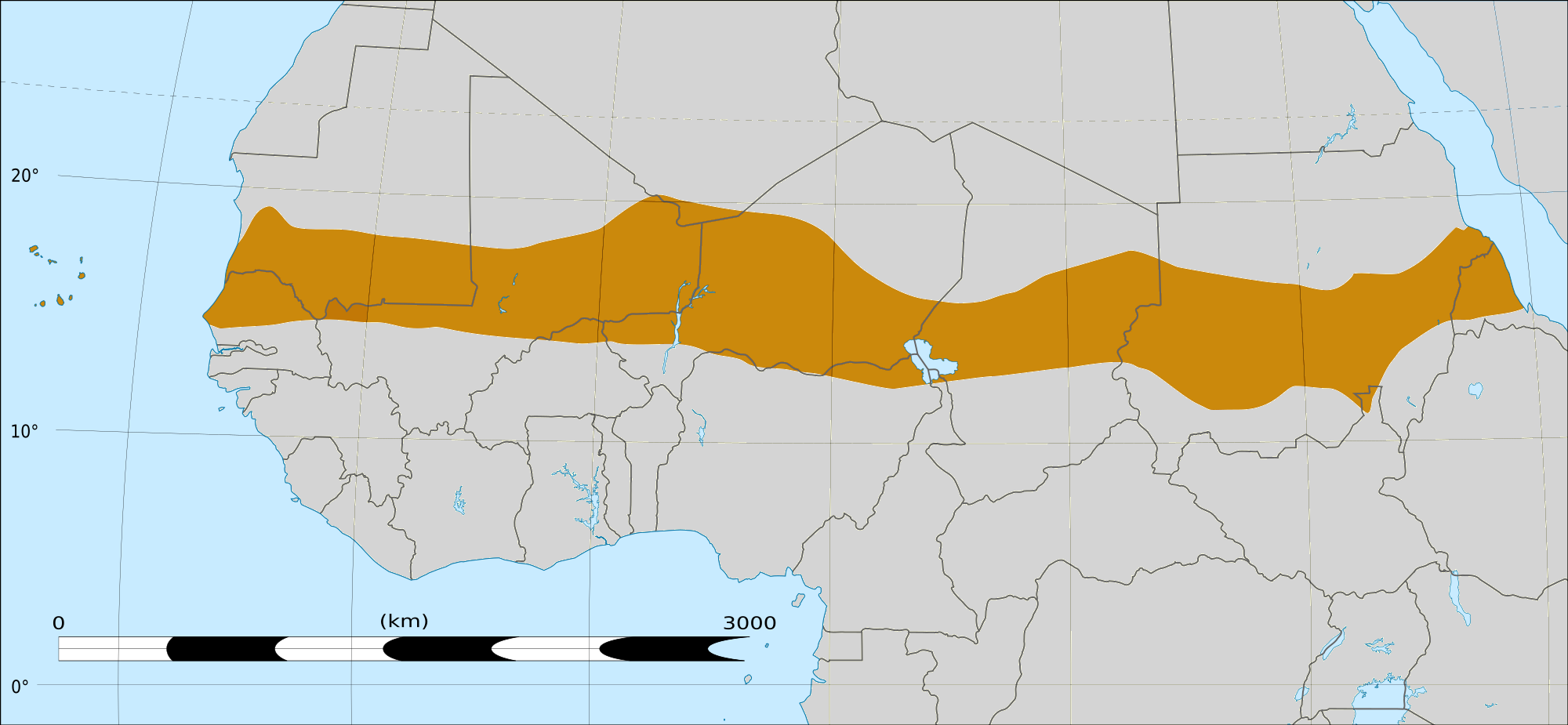
The Sahel region of Africa has long experienced a series of historic droughts, dating back to at least the 17th century. The Sahel region is a climate zone sandwiched between the Sudanian Savanna to the south and the Sahara desert to the north, across West and Central Africa. While the frequency of drought in the region is thought to have increased from the end of the 19th century, three long droughts have had dramatic environmental and societal effects upon the Sahel nations. Famine followed severe droughts in the 1910s, the 1940s, and the 1960s, 1970s and 1980s, although a partial recovery occurred from 1975-80. The most recent drought occurred in 2012. While at least one particularly severe drought has been confirmed each century since the 17th century, the frequency and severity of recent Sahelian droughts stands out. Famine and dislocation on a massive scale—from 1968 to 1974 and again in the early and mid-1980s—was blamed on two spikes in the severity of the 1960-1980 ... [...More Info...] [...Related Items...] OR: [Wikipedia] [Google] [Baidu] |
2010 Sahel Famine
A large-scale, drought-induced famine occurred in Africa's Sahel region and many parts of the neighbouring Sénégal River Area from February to August 2010. It is one of many famines to have hit the region in recent times. The Sahel is the ecoclimatic and biogeographic zone of transition between the Sahara desert in the north of Africa and the Sudanian savannas in the south, covering an area of 3,053,200 square kilometres. It is a transitional ecoregion of semi-arid grasslands, savannas, steppes, and thorn shrublands. The neighbouring Sénégal River Area contains various vegetation types and covers parts or all of Mauritania, Mali, Senegal and Guinea. It has also had very low rainfall over the last year according to the UN, NGOs and the Senegal River Basin Development Authority. [...More Info...] [...Related Items...] OR: [Wikipedia] [Google] [Baidu] |
Sous-préfecture
A subprefecture is an administrative division of a country that is below prefecture or province. Albania There are twelve Albanian counties or prefectures, each of which is divided into several districts, sometimes translated as subprefectures. :Examples: District of Korçë, District of Sarandë Brazil In Brazil the subprefectures ( pt, subprefeituras) are administrative divisions of some big cities, such as São Paulo and Rio de Janeiro. The head of a subprefecture, the ''subprefeito'', is indicated by the municipality's mayor (in Brazil called ''prefeito''). In São Paulo there are 32 subprefectures. The largest in total area, Parelheiros, covers 353.5 km2, and the most populous, Capela do Socorro, has more than 600,000 inhabitants. Burkina Faso Example: Djibasso Subprefecture Central African Republic Chad Examples: N'Gouri Subprefecture, Massakory Subprefecture China It was used in Qing Dynasty. Called ''ting'' (廳 or 厅) in Chinese, it is also on the s ... [...More Info...] [...Related Items...] OR: [Wikipedia] [Google] [Baidu] |
Chef-lieu
An administrative center is a seat of regional administration or local government, or a county town, or the place where the central administration of a commune is located. In countries with French as administrative language (such as Belgium, Luxembourg, Switzerland and many African countries), a (, plural form , literally 'chief place' or 'main place'), is a town or city that is important from an administrative perspective. Algeria The capital of an Algerian province is called a chef-lieu. The capital of a district, the next largest division, is also called a chef-lieu, whilst the capital of the lowest division, the municipalities, is called agglomération de chef-lieu (chef-lieu agglomeration) and is abbreviated as A.C.L. Belgium The chef-lieu in Belgium is the administrative centre of each of the ten provinces of Belgium. Three of these cities also give their name to their province ( Antwerp, Liège and Namur). France The chef-lieu of a département is known as the '' ... [...More Info...] [...Related Items...] OR: [Wikipedia] [Google] [Baidu] |
BEG Moussoro2
BEG may refer to: Transportation * BEG, IATA code for Belgrade Nikola Tesla Airport in Serbia * '' Bayerische Eisenbahngesellschaft'', the state rail transport authority for Bavaria Other uses * Bengal Engineer Group or Bombay Engineer Group The Bombay Engineer Group, or the ''Bombay Sappers'' as they are informally known, are a regiment of the Corps of Engineers of the Indian Army. The Bombay Sappers draw their origin from the erstwhile Bombay Presidency army of the British Ra ..., regiments of the Corps of Engineers of the Indian Army * Brown Eyed Girls, a South Korean girl group See also * Beg (other) {{disambiguation ... [...More Info...] [...Related Items...] OR: [Wikipedia] [Google] [Baidu] |
Peanut
The peanut (''Arachis hypogaea''), also known as the groundnut, goober (US), pindar (US) or monkey nut (UK), is a legume crop grown mainly for its edible seeds. It is widely grown in the tropics and subtropics, important to both small and large commercial producers. It is classified as both a grain legume and, due to its high oil content, an oil crop. World annual production of shelled peanuts was 44 million tonnes in 2016, led by China with 38% of the world total. Atypically among legume crop plants, peanut pods develop underground (geocarpy) rather than above ground. With this characteristic in mind, the botanist Carl Linnaeus gave peanuts the specific epithet ''hypogaea'', which means "under the earth." The peanut belongs to the botanical family Fabaceae (or Leguminosae), commonly known as the legume, bean, or pea family. Like most other legumes, peanuts harbor symbiotic nitrogen-fixing bacteria in root nodules. The capacity to fix nitrogen means peanuts require less ... [...More Info...] [...Related Items...] OR: [Wikipedia] [Google] [Baidu] |
Cotton
Cotton is a soft, fluffy staple fiber that grows in a boll, or protective case, around the seeds of the cotton plants of the genus '' Gossypium'' in the mallow family Malvaceae. The fiber is almost pure cellulose, and can contain minor percentages of waxes, fats, pectins, and water. Under natural conditions, the cotton bolls will increase the dispersal of the seeds. The plant is a shrub native to tropical and subtropical regions around the world, including the Americas, Africa, Egypt and India. The greatest diversity of wild cotton species is found in Mexico, followed by Australia and Africa. Cotton was independently domesticated in the Old and New Worlds. The fiber is most often spun into yarn or thread and used to make a soft, breathable, and durable textile. The use of cotton for fabric is known to date to prehistoric times; fragments of cotton fabric dated to the fifth millennium BC have been found in the Indus Valley civilization, as well as fabric remnants dat ... [...More Info...] [...Related Items...] OR: [Wikipedia] [Google] [Baidu] |
Ethnologue
''Ethnologue: Languages of the World'' (stylized as ''Ethnoloɠue'') is an annual reference publication in print and online that provides statistics and other information on the living languages of the world. It is the world's most comprehensive catalogue of languages. It was first issued in 1951, and is now published by SIL International, an American Christian non-profit organization. Overview and content ''Ethnologue'' has been published by SIL International (formerly known as the Summer Institute of Linguistics), a Christian linguistic service organization with an international office in Dallas, Texas. The organization studies numerous minority languages to facilitate language development, and to work with speakers of such language communities in translating portions of the Bible into their languages. Despite the Christian orientation of its publisher, ''Ethnologue'' isn't ideologically or theologically biased. ''Ethnologue'' includes alternative names and autonyms, t ... [...More Info...] [...Related Items...] OR: [Wikipedia] [Google] [Baidu] |
Kanembu People
The Kanembu are an ethnic group of Chad, generally considered the modern descendants of the Kanem-Bornu Empire. The Kanembu number an estimated 890,000 people, located primarily in Chad's Lac Prefecture but also in Chari-Baguirmi and Kanem prefectures. They speak the Kanembu language, which the Kanuri language is closely related to, with many speaking Arabic and sometimes nowadays French as a second language. Etymology The word ''Kanembu'' means "the people 'bu''of Kanem." History For over a thousand years the Kanem-Bornu Empire was a dominant power over central North Africa. Its sphere of influence covered Eastern Nigeria and Niger, the Northern half of Chad, Cameroon, and Libya. Its inhabitants traded with Egypt and sponsored Islamic schools as far as Alexandria. Its camel caravans reached the Muslim holy cities of Mecca and Medina. Until the beginning of the 1900s and the French conquest of this area, the Kanem-Bornu Empire was the major power in the heart of central ... [...More Info...] [...Related Items...] OR: [Wikipedia] [Google] [Baidu] |


_(10004827914).jpg)


