|
Punalur
Punalur is a Municipality in Kollam district of Kerala State in India. It is the headquarter of the Punalur Taluk and Punalur Revenue Division. It's situated in the eastern part of Kollam district of Kerala, on the banks of the Kallada River and foothills of the western ghats. It is about north-east of Kollam and north of Thiruvananthapuram. Etymology It is believed that Punalur derived its name by the word 'Punal' (river in old Tamil and Malayalam as in "kuruthipunal=river of blood" according to Dr. Hermann Gundert), and "Ooru" (place), referring to the river passing through the City. History Punalur is a Municipal town on a mountain path that had good relations with Tamil Nadu to the East from time unknown. Most parts of Punalur taluk were inhabited before the Indus Valley civilization. Human civilizations existed in Punalur during the Mesolithic period, mainly around Thenmalai (known as Shenduruny). Punalur is described in inscriptions of Mithranandpuram and Vellayan ... [...More Info...] [...Related Items...] OR: [Wikipedia] [Google] [Baidu] |
Kollam District
Kollam district (), (formerly Quilon district) is one of 14 districts of the state of Kerala, India. The district has a cross-section of Kerala's natural attributes; it is endowed with a long coastline, a major Laccadive Sea seaport and an inland lake (Ashtamudi Lake). The district has many water bodies. Kallada River is one among them, and the east side land of river is East Kallada and the west side land is West Kallada. Overview Kallada Boat race is one of the famous festival events of the district. Even though it is a competition between two land sides of the river, many boat clubs from various places, even beyond the district participate in the event. Kollam is the capital of Kerala's cashew industry. Plains, mountains, lakes, lagoons, and backwaters, forests, farmland and rivers make up the topography of the district. The area had trading relationships with Phoenicia and Ancient Rome. Climate Kollam's temperature is almost steady throughout the year. The average te ... [...More Info...] [...Related Items...] OR: [Wikipedia] [Google] [Baidu] |
PUNALUR SUSPENSION BRIDGE
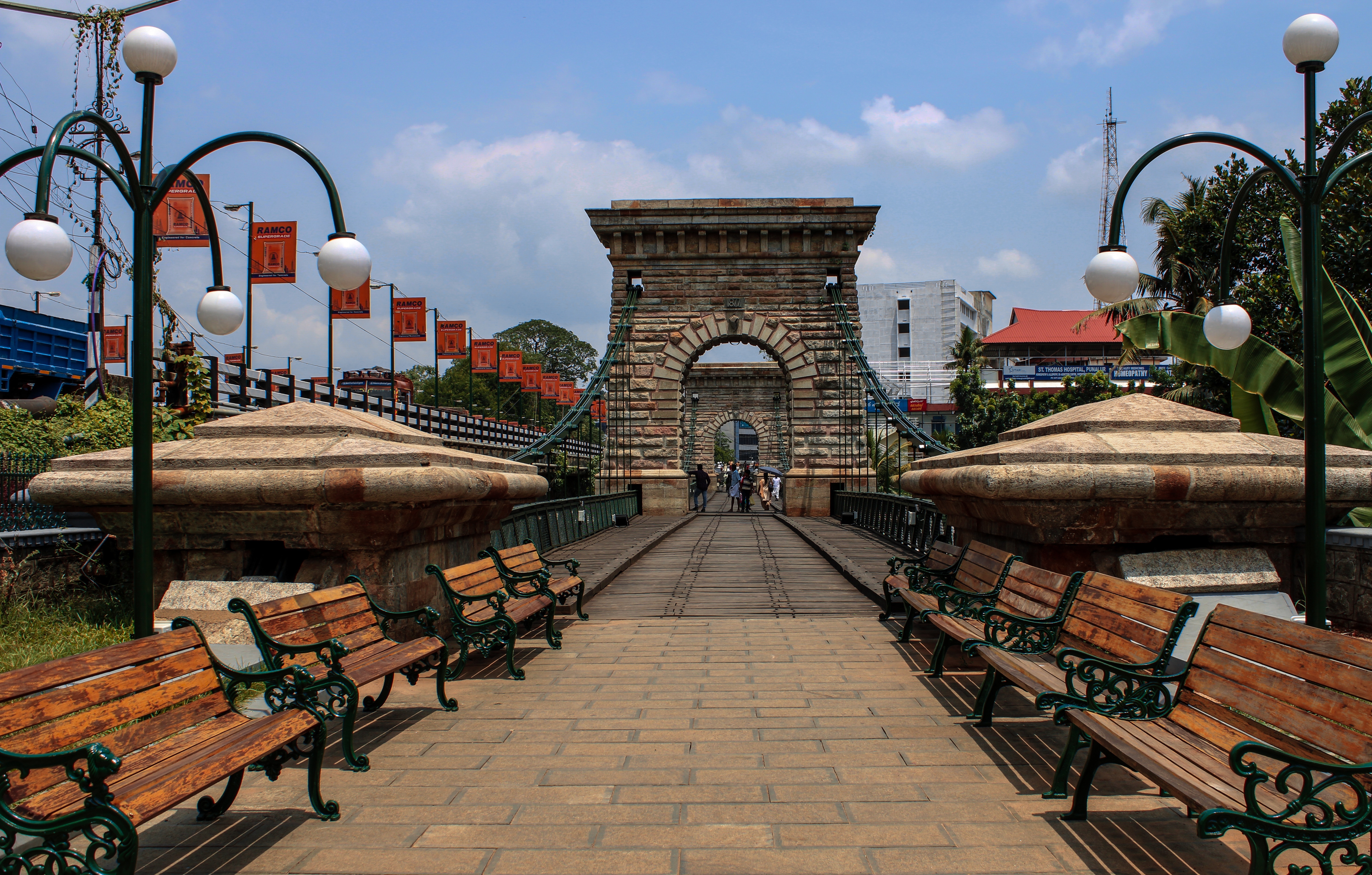
The Punalur Suspension Bridge, located in Punalur is the oldest motorable Bridge in Kerala, which was built by Travancore Government and is now a historical attraction. The bridge has a length of . The suspension bridge was built to prevent wild animals from crossing into the town from the forest area of old Kattupathanapuram. History and Construction The Punalur Suspension Bridge is the first motorable bridge in South India. The suspension bridge crossing the river is the only suspended-deck type in south India. Built in 1877 by Albert Henry across the Kallada River Kallada River/Kulathupuzha " Puzha "means River.Its's the longest river in Kollam District, Kerala, India.The river originates in Kulathupuzha,a part of Western Ghats and flows west reaching Arabian Sea after travelling a distance of 120km. Ri ..., this huge bridge was suspended by two spans and was used for vehicular movement. Construction took more than six years. It is said that after completion of ... [...More Info...] [...Related Items...] OR: [Wikipedia] [Google] [Baidu] |
Punalur Suspension Bridge
The Punalur Suspension Bridge, located in Punalur is the oldest motorable Bridge in Kerala, which was built by Travancore Government and is now a historical attraction. The bridge has a length of . The suspension bridge was built to prevent wild animals from crossing into the town from the forest area of old Kattupathanapuram. History and Construction The Punalur Suspension Bridge is the first motorable bridge in South India. The suspension bridge crossing the river is the only suspended-deck type in south India. Built in 1877 by Albert Henry across the Kallada River Kallada River/Kulathupuzha " Puzha "means River.Its's the longest river in Kollam District, Kerala, India.The river originates in Kulathupuzha,a part of Western Ghats and flows west reaching Arabian Sea after travelling a distance of 120km. Ri ..., this huge bridge was suspended by two spans and was used for vehicular movement. Construction took more than six years. It is said that after completion of ... [...More Info...] [...Related Items...] OR: [Wikipedia] [Google] [Baidu] |
Kallada River
Kallada River/Kulathupuzha " Puzha "means River.Its's the longest river in Kollam District, Kerala, India.The river originates in Kulathupuzha,a part of Western Ghats and flows west reaching Arabian Sea after travelling a distance of 120km. River Course The Kallada river originates from the south eastern part of the Kollam district. The river originates as multiple streams arising from Shendurney wildlife sanctuary. The most prominent among this are Kazhuthuruttiyaaru that arise from Rosemala and Ambanad Hills and flow southward, Kulathupuzha river that flow northward by arising from near Ponmudi hills and windward side of Agasthyamala Biosphere Reserve and west flowing streams that arise from windward side of Courtallam Hills. These major streams that form the river meet at Thenmala Dam. The river flows through the towns of Kulathupuzha, Thenmala, Ottackal, Ayiranalloor, Edamon, Punalur, Nedumkayam, Kamukumchery and Pathanapuram. It then enters the plains where it flows al ... [...More Info...] [...Related Items...] OR: [Wikipedia] [Google] [Baidu] |
Pathanapuram
Pathanapuram is a Town in Pathanapuram Taluk Kollam district, Kerala, India. Pathanapuram is a part of Grama Panchayat and Block panchayat of same name and part of Kollam District Panchayat. History The history of Pathanapuram goes back to Thenmala Desam, a small Principality under a local ruler. Capital was at Pathanapuram. Later, Thenmala Desom became a part of Elayidathu Swaroopam having its capital at Kottarakkara. Pathanapuram was the capital of one of the two districts of Elayidathu Swaroopam. In 1764, King Marthandavarma conquered Elayidathu Swaroopam and annexed it to Travancore. Most parts of Pathanapuram taluk were inhabited since before the Indus Valley civilization, and civilization may have existed in and around Pathanapuram beginning the 1st Century. The name Pathanapuram may have evolved from the fact that the area had a sizeable elephant population and elephants were caught and trained/tamed for work at the elephant cage/camp at the Town. The Old pol ... [...More Info...] [...Related Items...] OR: [Wikipedia] [Google] [Baidu] |
Kollam
Kollam (), also known by its former name Quilon , is an ancient seaport and city on the Malabar Coast of India bordering the Laccadive Sea, which is a part of the Arabian Sea. It is north of the state capital Thiruvananthapuram. The city is on the banks of Ashtamudi Lake and the Kallada river. It is the headquarters of the Kollam district. Kollam is the fourth largest city in Kerala and is known for cashew processing and coir manufacturing. It is the southern gateway to the Backwaters of Kerala and is a prominent tourist destination. Kollam has a strong commercial reputation since ancient times. The Arabs, Phoenicians, Chinese, Ethiopians, Syrians, Jews, Chaldeans and Romans have all engaged in trade at the port of Kollam for millennia. As a result of Chinese trade, Kollam was mentioned by Ibn Battuta in the 14th century as one of the five Indian ports he had seen during the course of his twenty-four-year travels. [...More Info...] [...Related Items...] OR: [Wikipedia] [Google] [Baidu] |
Municipalities Of Kerala
Kerala has an urbanisation rate of 47.42%, as compared to the national rate of 31.16%, making it the 2nd most urbanised major state in India. Within Kerala, the rate of urbanisation varied from 3.9% in Wayanad district, Wayanad district to 68.1% in Ernakulam district, Ernakulam district. Municipalities are the urban local governments that deal with civic functions and local development functions in the municipal area. The state of Kerala has 87 municipalities and six municipal corporations. With 13 municipalities, the district of Ernakulam has the most municipalities in the state. History The urban councils of Kerala date back to the 17th century when the Dutch Malabar established the municipality of Fort Kochi. In 1664, the municipality of Fort Kochi was established by Dutch Malabar, making it the first municipality in Indian subcontinent, which got dissolved when the Dutch authority got weaker in 18th century. However, the first modern kind of municipalities were formed in th ... [...More Info...] [...Related Items...] OR: [Wikipedia] [Google] [Baidu] |
Venad
Venad was a medieval kingdom lying between the Western Ghat mountains and the Arabian Sea on the south-western tip of India with its headquarters at the port city of Kollam/Quilon.Noburu Karashmia (ed.), A Concise History of South India: Issues and Interpretations. New Delhi: Oxford University Press, 2014. 143-44.Narayanan, M. G. S. 2002. ‘The State in the Era of the Ceraman Perumals of Kerala’, in ''State and Society in Premodern South India'', eds R. Champakalakshmi, Kesavan Veluthat, and T. R. Venugopalan, pp.111–19. Thrissur, CosmoBooks. It was one of the major principalities of Kerala, along with kingdoms of Kannur (Kolathunadu), Kozhikode (Nediyiruppu), and Kochi ( Perumpadappu) in medieval and early modern period.Menon, T. Madhava. ''A Handbook of Kerala.'' Vol 1. Trivandrum: Dravidian Linguistics Association, 2002/ref> Rulers of Venad trace their ancestry to the Vel chieftains related to the Ay dynasty, Ay lineage of the early historic south India (c. 1st – ... [...More Info...] [...Related Items...] OR: [Wikipedia] [Google] [Baidu] |
Marthanda Varma
Anizham Thirunal Marthanda Varma (Malayalam: ) was the founding monarch of the southern Indian Kingdom of Travancore (previously Venadu) from 1729 until his death in 1758. He was succeeded by Rama Varma ("Dharma Raja") (1758–98).Subrahmanyam, Sanjay''The south: Travancore and Mysore''"India". Encyclopædia Britannica. Marthanda Varma defeated the Dutch East India Company forces at the Battle of Colachel in 1741.He also put an end to the ettuveetil pillamars and the ettara yogam council and took the full power as a king. The Yogakars and Pillamars were always against the Royal Family of Venad (Padmabhaswamy Temple Judgement page :16) He then adopted a European mode of discipline for his army and expanded his kingdom northward (to what became the modern state of Travancore). He built a sizeable standing army of about 50,000 nair men, as part of designing an "elaborate and well-organised" war machine, with the role of the travancore army and fortified the northern boundary of ... [...More Info...] [...Related Items...] OR: [Wikipedia] [Google] [Baidu] |
Travancore
The Kingdom of Travancore ( /ˈtrævənkɔːr/), also known as the Kingdom of Thiruvithamkoor, was an Indian kingdom from c. 1729 until 1949. It was ruled by the Travancore Royal Family from Padmanabhapuram, and later Thiruvananthapuram. At its zenith, the kingdom covered most of the south of modern-day Kerala ( Idukki, Kottayam, Alappuzha, Pathanamthitta, Kollam, and Thiruvananthapuram districts, and some portions of Ernakulam district), and the southernmost part of modern-day Tamil Nadu (Kanyakumari district and some parts of Tenkasi district) with the Thachudaya Kaimal's enclave of Irinjalakuda Koodalmanikyam temple in the neighbouring Kingdom of Cochin. However Tangasseri area of Kollam city and Anchuthengu near Attingal in Thiruvananthapuram district, were British colonies and were part of the Malabar District until 30 June 1927, and Tirunelveli district from 1 July 1927 onwards. Travancore merged with the erstwhile princely state of Cochin to form Travancore-Cochin i ... [...More Info...] [...Related Items...] OR: [Wikipedia] [Google] [Baidu] |
WikiProject Indian Cities
A WikiProject, or Wikiproject, is a Wikimedia movement affinity group for contributors with shared goals. WikiProjects are prevalent within the largest wiki, Wikipedia, and exist to varying degrees within sister projects such as Wiktionary, Wikiquote, Wikidata, and Wikisource. They also exist in different languages, and translation of articles is a form of their collaboration. During the COVID-19 pandemic, CBS News noted the role of Wikipedia's WikiProject Medicine in maintaining the accuracy of articles related to the disease. Another WikiProject that has drawn attention is WikiProject Women Scientists, which was profiled by '' Smithsonian'' for its efforts to improve coverage of women scientists which the profile noted had "helped increase the number of female scientists on Wikipedia from around 1,600 to over 5,000". On Wikipedia Some Wikipedia WikiProjects are substantial enough to engage in cooperative activities with outside organizations relevant to the field at issue. For ex ... [...More Info...] [...Related Items...] OR: [Wikipedia] [Google] [Baidu] |
Indus Valley Civilization
The Indus Valley Civilisation (IVC), also known as the Indus Civilisation was a Bronze Age civilisation in the northwestern regions of South Asia, lasting from 3300 BCE to 1300 BCE, and in its mature form 2600 BCE to 1900 BCE. Together with ancient Egypt and Mesopotamia, it was one of three early civilisations of the Near East and South Asia, and of the three, the most widespread. Its sites spanned an area from much of Pakistan, to northeast Afghanistan, and northwestern India. The civilisation flourished both in the alluvial plain of the Indus River, which flows through the length of Pakistan, and along a system of perennial monsoon-fed rivers that once coursed in the vicinity of the Ghaggar-Hakra, a seasonal river in northwest India and eastern Pakistan. The term ''Harappan'' is sometimes applied to the Indus civilisation after its type site Harappa, the first to be excavated early in the 20th century in what was then the Punjab province o ... [...More Info...] [...Related Items...] OR: [Wikipedia] [Google] [Baidu] |


.jpg)
