|
Precision Approach Radar
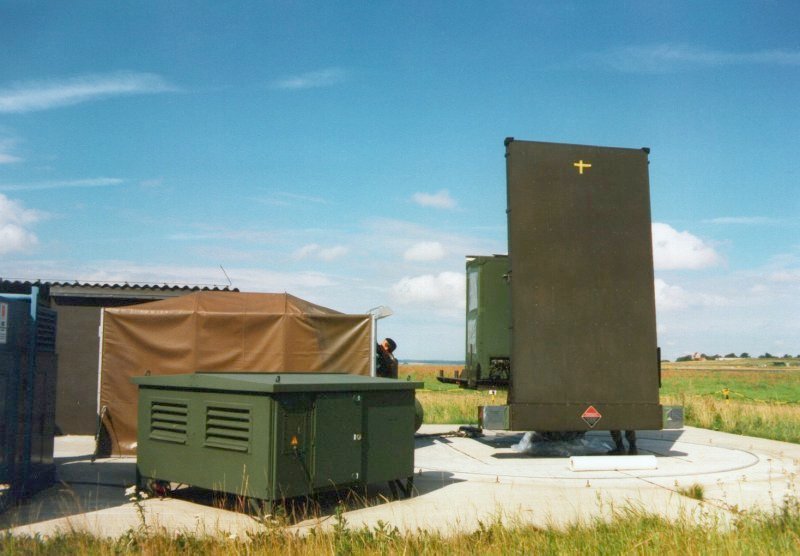
Precision approach radar (PAR) is a type of radar guidance system designed to provide lateral and vertical guidance to an aircraft pilot for landing, until the landing threshold is reached. Controllers monitoring the PAR displays observe each aircraft's position and issue instructions to the pilot that keep the aircraft on course and glidepath during final approach. After the aircraft reaches the decision height (DH) or decision altitude (DA), further guidance is advisory only. The overall concept is known as ground-controlled approach (GCA), and this name was also used to refer to the radar systems in the early days of its development. PAR radars use a unique type of radar display with two separate "traces", separated vertically. The upper trace shows the elevation of a selected aircraft compared to a line displaying the ideal glideslope, while the lower shows the aircraft's horizontal position relative to the runway midline. GCA approaches normally start with the controller rel ... [...More Info...] [...Related Items...] OR: [Wikipedia] [Google] [Baidu] |
Multilateration
Trilateration is the use of distances (or "ranges") for determining the unknown position coordinates of a point of interest, often around Earth ( geopositioning). When more than three distances are involved, it may be called multilateration, for emphasis. The distances or ranges might be ordinary Euclidean distances (slant ranges) or spherical distances (scaled central angles), as in '' true-range multilateration''; or biased distances ( pseudo-ranges), as in '' pseudo-range multilateration''. Trilateration or multilateration should not be confused with ''triangulation'', which uses angles for positioning; and '' direction finding'', which determines the line of sight direction to a target without determining the radial distance. Terminology Multiple, sometimes overlapping and conflicting terms are employed for similar concepts – e.g., ''multilateration'' without modification has been used for aviation systems employing both true-ranges and pseudo-ranges."Multilateration ( ... [...More Info...] [...Related Items...] OR: [Wikipedia] [Google] [Baidu] |
Instrument Approach
In aviation, an instrument approach or instrument approach procedure (IAP) is a series of predetermined maneuvers for the orderly transfer of an aircraft operating under instrument flight rules from the beginning of the initial approach to a landing, or to a point from which a landing may be made visually. These approaches are approved in the European Union by EASA and the respective country authorities and in the United States by the FAA or the United States Department of Defense for the military. The ICAO defines an instrument approach as, "a series of predetermined maneuvers by reference to flight instruments with specific protection from obstacles from the initial approach fix, or where applicable, from the beginning of a defined arrival route to a point from which a landing can be completed and thereafter, if landing is not completed, to a position at which holding or enroute obstacle clearance criteria apply." There are three categories of instrument approach procedures: p ... [...More Info...] [...Related Items...] OR: [Wikipedia] [Google] [Baidu] |
Acronyms And Abbreviations In Avionics
Below are abbreviations used in aviation, avionics, aerospace and aeronautics. A B C D E F G H I J K L M N N numbers (turbines) O P Q R S T U V V speeds W X Y Z See also * List of aviation mnemonics * Avionics * Glossary of Russian and USSR aviation acronyms * Glossary of gliding and soaring This is a Wikipedia:Manual of Style (glossaries), glossary of acronyms, initialisms and terms used for gliding and soaring. This is a specialized subset of broader aviation, aerospace, and aeronautical terminology. Additional definitions can be fou ... * Appendix:Glossary of aviation, aerospace, and aeronautics – Wiktionary References SourcesAerospace acronymsTerms and GlossaryAviada Terminaro verkita de Gilbert R. LEDON, 286 pagxoj. External links Acronyms used by EASAAcronyms and Abbreviations- FAA Aviation DictionaryAviation Acronyms and AbbreviationsAcronyms search engine by Eurocontrol {{DEFAULTSORT:aviation, av ... [...More Info...] [...Related Items...] OR: [Wikipedia] [Google] [Baidu] |
Instrument Landing System
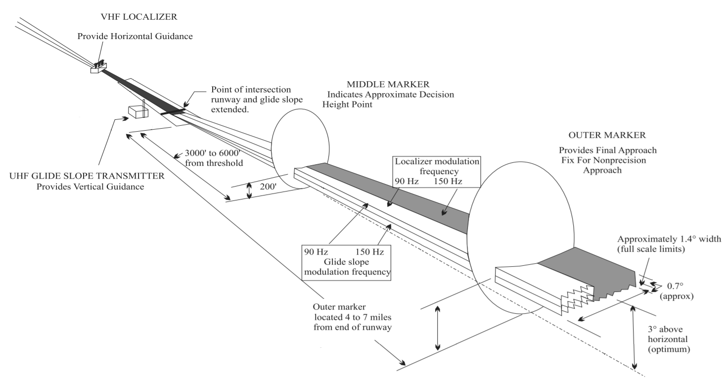
In aviation, the instrument landing system (ILS) is a precision radio navigation system that provides short-range guidance to aircraft to allow them to approach a runway at night or in bad weather. In its original form, it allows an aircraft to approach until it is over the ground, within a of the runway. At that point the runway should be visible to the pilot; if it is not, they perform a missed approach. Bringing the aircraft this close to the runway dramatically increases the range of weather conditions in which a safe landing can be made. Other versions of the system, or "categories", have further reduced the minimum altitudes, runway visual ranges (RVRs), and transmitter and monitoring configurations designed depending on the normal expected weather patterns and airport safety requirements. ILS uses two directional radio signals, the ''localizer'' (108 to 112 MHz frequency), which provides horizontal guidance, and the ''glideslope'' (329.15 to 335 MHz frequenc ... [...More Info...] [...Related Items...] OR: [Wikipedia] [Google] [Baidu] |
ICAO
The International Civil Aviation Organization (ICAO, ) is a specialized agency of the United Nations that coordinates the principles and techniques of international air navigation, and fosters the planning and development of international air transport to ensure safe and orderly growth. ICAO headquarters are located in the '' Quartier International'' of Montreal, Quebec, Canada. The ICAO Council adopts standards and recommended practices concerning air navigation, its infrastructure, flight inspection, prevention of unlawful interference, and facilitation of border-crossing procedures for international civil aviation. ICAO defines the protocols for air accident investigation that are followed by transport safety authorities in countries signatory to the Chicago Convention on International Civil Aviation. The Air Navigation Commission (ANC) is the technical body within ICAO. The commission is composed of 19 commissioners, nominated by the ICAO's contracting states and ... [...More Info...] [...Related Items...] OR: [Wikipedia] [Google] [Baidu] |
Flight Inspection
Flight inspection refers to the periodic evaluation of navigational aids used in aviation, such as flight procedures and electronic signals, to ensure they are safe and accurate. Unlike flight tests, which analyze the aerodynamic design and safety of the aircraft itself, flight inspection comprises reviewing flight procedures (such as routes, approaches and departures) to ensure navigational support is sufficient, there are no obstacles and the procedure is reliable. Flight inspectors originally tested the accuracy of light beacons sighted while flying. These beacons allowed pilots to fly at night with visual guidance. Radio navigation systems followed, with inspectors testing the radio transmitters while airborne, and then GPS. Customized aircraft are used for flight inspection, with dedicated receivers and sensors to collect data from the navigational aids being inspected. Computers decode the data and compare to the real aircraft position, with results displayed to the inspec ... [...More Info...] [...Related Items...] OR: [Wikipedia] [Google] [Baidu] |
Rain Fade
Rain fade refers primarily to the absorption of a microwave radio frequency (RF) signal by atmospheric rain, snow, or ice, and losses which are especially prevalent at frequencies above 11 GHz. It also refers to the degradation of a signal caused by the electromagnetic interference of the leading edge of a storm front. Rain fade can be caused by precipitation at the uplink or downlink location. It does not need to be raining at a location for it to be affected by rain fade, as the signal may pass through precipitation many miles away, especially if the satellite dish has a low look angle. From 5% to 20% of rain fade or satellite signal attenuation may also be caused by rain, snow, or ice on the uplink or downlink antenna reflector, radome, or feed horn. Rain fade is not limited to satellite uplinks or downlinks, as it can also affect terrestrial point-to-point microwave links (those on the earth's surface). Rain fade is usually estimated experimentally and also can be calculat ... [...More Info...] [...Related Items...] OR: [Wikipedia] [Google] [Baidu] |
L-band
The L band is the Institute of Electrical and Electronics Engineers (IEEE) designation for the range of frequencies in the radio spectrum from 1 to 2 gigahertz (GHz). This is at the top end of the ultra high frequency (UHF) band, at the lower end of the microwave range. Applications Mobile service In Europe, the Electronic Communications Committee (ECC) of the European Conference of Postal and Telecommunications Administrations (CEPT) has harmonized part of the L band (1452–1492 MHz), allowing individual countries to adopt this spectrum for terrestrial mobile/fixed communications networks supplemental downlink (MFCN SDL). By means of carrier aggregation, an LTE-Advanced or UMTS/HSDPA base station could use this spectrum to provide additional bandwidth for communications from the base station to the mobile device; i.e., in the downlink direction. In the Americas, mobile services are operated between the 1.7 GHz to 2.1 GHz range in the PCS and AWS bands. ... [...More Info...] [...Related Items...] OR: [Wikipedia] [Google] [Baidu] |
Secondary Surveillance Radar
Secondary surveillance radar (SSR)''Secondary Surveillance Radar'', Stevens M.C. Artech House, is a radar system used in air traffic control (ATC), that unlike primary radar systems that measure the bearing and distance of targets using the detected reflections of radio signals, relies on targets equipped with a radar transponder, that reply to each interrogation signal by transmitting encoded data such as an identity code, the aircraft's altitude and further information depending on its chosen mode. SSR is based on the military identification friend or foe (IFF) technology originally developed during World War II, therefore the two systems are still compatible. Monopulse secondary surveillance radar (MSSR), Mode S, TCAS and ADS-B are similar modern methods of secondary surveillance. Overview Primary radar The rapid wartime development of radar had obvious applications for air traffic control (ATC) as a means of providing continuous surveillance of air traffic dispositi ... [...More Info...] [...Related Items...] OR: [Wikipedia] [Google] [Baidu] |


