|
Nyūdō-bōzu
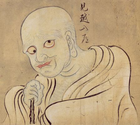
Nyūdō-bōzu ( ja, 入道坊主) are yōkai first known in Tsukude, Minamishitara District, Aichi Prefecture (now Shinshiro), and then also in Fukushima Prefecture; Kurikoma, Kurihara District, Miyagi Prefecture (now Kurihara); Hirano, Suwa District, Nagano Prefecture (now Okaya), among other places. Legend It is a yōkai that becomes larger the further one looks up, and is thus considered a type of ''mikoshi-nyūdō'', which has the same characteristics. In Aichi Prefecture, it appears as a small ''bōzu'' that has a height that is not even 3 shaku (about 1 meter), but when people who meet them get close to it, it would then increase in height and become a large man about 7 or 8 ''shaku'' to 1 ''to'' (about 2 to 3 meters). It is said that by saying to it "," it is possible to make it disappear, but in reverse if it says something instead, it results in death. In Fukushima Prefecture, it is said to be a weasel. When one looks up at a nyūdō-bōzu, it would gnaw at people's w ... [...More Info...] [...Related Items...] OR: [Wikipedia] [Google] [Baidu] |
Weasel
Weasels are mammals of the genus ''Mustela'' of the family Mustelidae. The genus ''Mustela'' includes the least weasels, polecats, stoats, ferrets and European mink. Members of this genus are small, active predators, with long and slender bodies and short legs. The family Mustelidae, or mustelids (which also includes badgers, otters, and wolverines), is often referred to as the "weasel family". In the UK, the term "weasel" usually refers to the smallest species, the least weasel (''M. nivalis''), the smallest carnivoran species. Least weasels vary in length from , females being smaller than the males, and usually have red or brown upper coats and white bellies; some populations of some species moult to a wholly white coat in winter. They have long, slender bodies, which enable them to follow their prey into burrows. Their tails may be from long. Weasels feed on small mammals and have from time to time been considered vermin because some species took poultry from far ... [...More Info...] [...Related Items...] OR: [Wikipedia] [Google] [Baidu] |
Mikoshi-nyūdō
Mikoshi-nyūdō (見越し入道 or 見越入道) is a type of bald-headed ''yōkai'' "goblin" with an ever-extending neck. In Japanese folklore and Edo period (1603–1868) ''kaidan'' "ghost story" texts, ''mikoshi-nyūdō'' will frighten people who look over the top of things such as ''byōbu'' folding screens. The name combines ''mikoshi'' 見越し (lit. "see over") "looking over the top (of a fence); anticipation; expectation" and ''nyūdō'' 入道 (lit. "enter the Way") "a (Buddhist) priest; a bonze; a tonsured monster". Summary When walking to the end of a road at night or a hill road, something the shape of a monk would suddenly appear, and if one looks up, it becomes taller the further one looks up. They are so big that one would look up at them, and thus are given the name "." Sometimes, if one just looks at them like that, one might die, but they can be made to disappear by saying "." They most frequently appear when walking alone on night paths, but they are also s ... [...More Info...] [...Related Items...] OR: [Wikipedia] [Google] [Baidu] |
Yōkai
are a class of supernatural entities and spirits in Japanese folklore. The word is composed of the kanji for "attractive; calamity" and "apparition; mystery; suspicious." are also referred to as , or . Despite often being translated as such, are not literally demons in the Western sense of the word, but are instead spirits and entities. Their behavior can range from malevolent or mischievous to benevolent to humans. often have animal features (such as the , depicted as appearing similar to a turtle, and the , commonly depicted with wings), but may also appear humanoid in appearance, such as the . Some resemble inanimate objects (such as the ), while others have no discernible shape. are typically described as having spiritual or supernatural abilities, with shapeshifting being the most common trait associated with them. that shapeshift are known as or . Japanese folklorists and historians explain as personifications of "supernatural or unaccountable phenomena to th ... [...More Info...] [...Related Items...] OR: [Wikipedia] [Google] [Baidu] |
Suwa District, Nagano
is a district located in Nagano Prefecture, Japan. As of 2003, the district has an estimated population of 46,162 and a density of 181.18 persons per km2. The total area is 254.79 km2. Towns and villages * Hara * Fujimi *Shimosuwa is a town located in Nagano Prefecture, Japan. , the town had an estimated population of 20,055 in 8864 households, and a population density of 300 persons per km². The total area of the town is . Geography Shimosuwa is located in central Na ... Districts in Nagano Prefecture {{Nagano-geo-stub ... [...More Info...] [...Related Items...] OR: [Wikipedia] [Google] [Baidu] |
Mujina
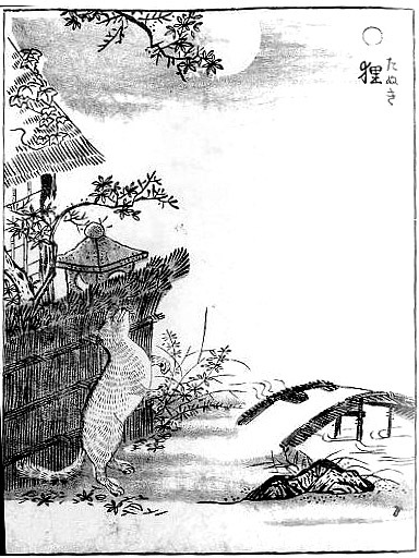
is an old Japanese term primarily referring to the Japanese badger, but traditionally to the Japanese raccoon dog (''tanuki''), causing confusion. Adding to the confusion, it may also refer to the introduced masked palm civet, and in some regions badger-like animals or Japanese raccoon dog are also called ''mami''. Appearance The ''mujina'' is said to be a raccoon-faced creature in its natural form, with the main body being that of a Japanese badger. In some parts of Japan, they are incorrectly referred to as the ''tanuki'', with whom they are closely related to in terms of appearance as well as actions- even though the ''tanuki'' are biologically related to the fox and dog.Reeves, David. “A Brief Introduction to Aoki Rosui and Annotated Translation of his Text Otogi Hyaku Monogatari.” ''Masters Theses'', 240, 2015, pp. 37-40. https://doi.org/10.7275/7012662. Accessed 25 Nov 2022. The ''mujina'' in specific are known to be able to inflate their bellies, creating music by ... [...More Info...] [...Related Items...] OR: [Wikipedia] [Google] [Baidu] |
Bake-danuki
''Bake-danuki'' () are a kind of ''yōkai'' (supernatural beings) found in the classics and in the folklore and legends of various places in Japan, commonly associated with the Japanese raccoon dog or ''tanuki''. Although the ''tanuki'' is a real, extant animal, the ''bake-danuki'' that appears in literature has always been depicted as a strange, even supernatural animal. The earliest appearance of the ''bake-danuki'' in literature, in the chapter about Empress Suiko in the '' Nihon Shoki'' written during the Nara period, there are such passages as "in two months of spring, there are tanuki in the country of Mutsu (), they turn into humans and sing songs ()." Bake-danuki subsequently appear in such classics as the Nihon Ryōiki and the Uji Shūi Monogatari. In some regions of Japan, ''bake-danuki'' are reputed to have abilities similar to those attributed to ''kitsune'' (foxes): they can shapeshift into other things or people, and can possess human beings. Many legends of ''tanuk ... [...More Info...] [...Related Items...] OR: [Wikipedia] [Google] [Baidu] |
Okaya, Nagano
is a city located in Nagano Prefecture, Japan. , the city had an estimated population of 48,616 in 19,257 households, and a population density of 570 persons per km². The total area of the city is . Geography Okaya is located in central Nagano Prefecture at the western shores of Lake Suwa and the headwaters of the Tenryū River. Surrounding municipalities *Nagano Prefecture ** Matsumoto ** Shiojiri ** Suwa ** Shimosuwa ** Tatsuno Climate The city has a climate characterized by characterized by hot and humid summers, and relatively mild winters (Köppen climate classification ''Cfa''). The average annual temperature in Okaya is 10.6 °C. The average annual rainfall is 1281 mm with September as the wettest month. The temperatures are highest on average in August, at around 23.6 °C, and lowest in January, at around -1.9 °C. Demographics Per Japanese census data, the population of Okaya has declined over the past 50 years. History The area of presen ... [...More Info...] [...Related Items...] OR: [Wikipedia] [Google] [Baidu] |
Nagano Prefecture
is a landlocked prefecture of Japan located in the Chūbu region of Honshū. Nagano Prefecture has a population of 2,052,493 () and has a geographic area of . Nagano Prefecture borders Niigata Prefecture to the north, Gunma Prefecture to the northeast, Saitama Prefecture to the east, Yamanashi Prefecture to the southeast, Shizuoka Prefecture and Aichi Prefecture to the south, and Gifu Prefecture and Toyama Prefecture to the west. Nagano is the capital and largest city of Nagano Prefecture, with other major cities including Matsumoto, Ueda, and Iida. Nagano Prefecture has impressive highland areas of the Japanese Alps, including most of the Hida Mountains, Kiso Mountains, and Akaishi Mountains which extend into the neighbouring prefectures. The abundance of mountain ranges, natural scenic beauty, and rich history has gained Nagano Prefecture international recognition as a world-class winter sports tourist destination, including hosting the 1998 Winter Olympics and a new ... [...More Info...] [...Related Items...] OR: [Wikipedia] [Google] [Baidu] |
Kurihara, Miyagi
Kurihara City Hall is a city located in Miyagi Prefecture, Japan. , the city had an estimated population of 66,565, and a population density of 83 persons per km2 in 24,994 households. The total area of the city is . Parts of the city are within the borders of the Kurikoma Quasi-National Park. Geography Kurihara covers a part of the northwestern corner of Miyagi Prefecture. It is mostly rice farmland, and small mountain ridges, the largest of which cluster around Mount Kurikoma, the tallest mountain in Kurihara, which is located at the furthest northwestern point of Miyagi Prefecture. In summer, the lotus on Lake Izunuma bloom. In fall, Mount Kurikoma is covered in fall colors and in winter migrating swans and geese come in flocks to spend the season on Kurihara's lakes. Neighboring municipalities Miyagi Prefecture * Tome * Ōsaki Akita Prefecture * Yuzawa * Higashinaruse Iwate Prefecture *Ichinoseki Climate The climate of Kurihara is classified as humid subtropical (Cfa) per ... [...More Info...] [...Related Items...] OR: [Wikipedia] [Google] [Baidu] |
Tsukude, Aichi
was a village located in Minamishitara District, Aichi Prefecture, Japan. As of May 1, 2004, the village had an estimated population of 3,263 and a . Its total area was . Geography Tsukude was located in east-central of Aichi Prefecture. Some 90 percent of the village area was covered in mountains and forest, and most was within the borders of the Aichi Kōgen Quasi-National Park History Tsukude was home to the Okudaira clan during the Sengoku period, and to the short-lived Tsukude Domain under the Tokugawa Shogunate of the Edo period. Modern Tsukude village was created through the merger of nine small hamlets on May 1, 1906. On October 1, 2005, Tsukude, along with the town of Hōrai (also from Minamishitara District), was merged into the expanded city of Shinshiro and has ceased to exist as an independent municipality A municipality is usually a single administrative division having corporate status and powers of self-government or jurisdiction as granted by national ... [...More Info...] [...Related Items...] OR: [Wikipedia] [Google] [Baidu] |
Miyagi Prefecture
is a prefecture of Japan located in the Tōhoku region of Honshu. Miyagi Prefecture has a population of 2,305,596 (1 June 2019) and has a geographic area of . Miyagi Prefecture borders Iwate Prefecture to the north, Akita Prefecture to the northwest, Yamagata Prefecture to the west, and Fukushima Prefecture to the south. Sendai is the capital and largest city of Miyagi Prefecture, and the largest city in the Tōhoku region, with other major cities including Ishinomaki, Ōsaki, and Tome. Miyagi Prefecture is located on Japan's eastern Pacific coast and bounded to the west by the Ōu Mountains, the longest mountain range in Japan, with 24% of its total land area being designated as Natural Parks. Miyagi Prefecture is home to Matsushima Islands, a group of islands ranked as one of the Three Views of Japan, near the town of Matsushima. On 7 April, 2011 the biggest earthquake in Japan occurred. History Miyagi Prefecture was formerly part of the province of Mutsu. 2011 T ... [...More Info...] [...Related Items...] OR: [Wikipedia] [Google] [Baidu] |
Kurihara District, Miyagi
was a district in Japan belonging to Mutsu Province (currently to Miyagi Prefecture). Established in the 8th century as Korehari or Koreharu District (伊治郡) and abolished in 2005, the territory is identical to the city of Kurihara today. Kurihara was established as Korehari in the 8th century as a frontier district of the Mutsu Province. At that time, Korehari was the northern limit of the Japanese dominance at the pacific side of the region. Ancient Japan had continued conquest wars against Emishi. One time in 780 the district head and an Emishi officer in Japanese army, Korehari no Azamaro, revolted at the Korehari Castle and killed the governor of the Tohoku area. Much later Korehari had its name changed to Kurihara. The district occupied the northwest part of the Sendai Plain. The population had enjoyed fertile land for rice cultivation. In addition, Kurihara has a relatively peaceful history with few if any warloads hailing from the district. The Date clan had rule ... [...More Info...] [...Related Items...] OR: [Wikipedia] [Google] [Baidu] |
.jpg)


