|
List Of Rivers Of Ohio
Ohio is a Midwestern state in the Great Lakes region of the United States. The state takes its name from the Ohio River, whose name in turn originated from the Seneca word '' ohiːyo, meaning "good river", "great river" or "large creek". The Ohio River forms its southern border, though nearly all of the river itself belongs to Kentucky and West Virginia. Significant rivers within the state include the Cuyahoga River, Great Miami River, Maumee River, Muskingum River, and Scioto River. The rivers in the northern part of the state drain into the northern Atlantic Ocean via Lake Erie and the St. Lawrence River, and the rivers in the southern part of the state drain into the Gulf of Mexico via the Ohio River and then the Mississippi. The worst weather disaster in Ohio history occurred along the Great Miami River in 1913. Known as the Great Dayton Flood, the entire Miami River watershed flooded, including the downtown business district of Dayton. As a result, the Miami Conservancy Di ... [...More Info...] [...Related Items...] OR: [Wikipedia] [Google] [Baidu] |
Ohio
Ohio () is a state in the Midwestern region of the United States. Of the fifty U.S. states, it is the 34th-largest by area, and with a population of nearly 11.8 million, is the seventh-most populous and tenth-most densely populated. The state's capital and largest city is Columbus, with the Columbus metro area, Greater Cincinnati, and Greater Cleveland being the largest metropolitan areas. Ohio is bordered by Lake Erie to the north, Pennsylvania to the east, West Virginia to the southeast, Kentucky to the southwest, Indiana to the west, and Michigan to the northwest. Ohio is historically known as the "Buckeye State" after its Ohio buckeye trees, and Ohioans are also known as "Buckeyes". Its state flag is the only non-rectangular flag of all the U.S. states. Ohio takes its name from the Ohio River, which in turn originated from the Seneca word ''ohiːyo'', meaning "good river", "great river", or "large creek". The state arose from the lands west of the Appalachian Mountai ... [...More Info...] [...Related Items...] OR: [Wikipedia] [Google] [Baidu] |
Alum Creek (Ohio)
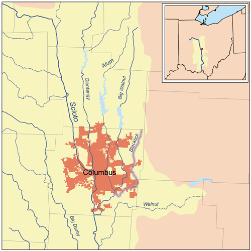
Alum Creek is long creek that runs north to south in central Ohio. The creek originates in Morrow County and then flows through Delaware County and finally into Franklin County, where it ends at Big Walnut Creek, which drains into the Scioto River. Alum Creek is a source of drinking water for the city of Westerville, Ohio. History The Alum Creek valley was inhabited by the Adena over 2,000 years ago. This mound builder culture constructed seven mounds along Alum Creek. The Lenape (Delaware) Indian tribe later established many settlements near the creek. One of the first European settlers was Colonel Moses Byxbe, who constructed his home on Alum Creek in 1805. Colonel Byxbe owned or co-owned along the creek. As a defensive measure during the War of 1812, local residents built four blockhouses in the area, including one on Alum Creek. The blockhouse, Fort Cheshire, was a 2-story log fortress, constructed so as to provide a place from which to shoot, drop boiling water, and ... [...More Info...] [...Related Items...] OR: [Wikipedia] [Google] [Baidu] |
Brandywine Creek (Cuyahoga River Tributary)
Brandywine Creek is a tributary of the Cuyahoga River that is partly contained in Cuyahoga Valley National Park in Ohio. Watershed The river runs into the Cuyahoga River in Sagamore Hills, Township, Summit County, Ohio, Sagamore Hills Township near the now-abandoned Jaite, Jaite Paper Mill. Discharge volume is extremely seasonal, usually a few cubic feet per second, and peaking at several hundred cubic feet per second under flood conditions. The Brandywine Creek drainage basin, watershed begins in the northern portion of Hudson, Ohio, Hudson, and includes the cities of Hudson, Macedonia, Ohio, Macedonia and Twinsburg, Ohio, Twinsburg, and the townships of Boston Township, Summit County, Ohio, Boston, Sagamore Hills, and Northfield Center Township, Summit County, Ohio, Northfield Center. Brandywine Falls Brandywine Falls, high, at , Elevation: within Cuyahoga Valley National Park, is accessed by a parking lot located on Stanford Road, about from Brandywine Road, approximately ... [...More Info...] [...Related Items...] OR: [Wikipedia] [Google] [Baidu] |
Brandywine Creek (Broken Sword Creek Tributary)
Brandywine CreekUnited States Geological Survey Hydrological Unit Code: 04-10-00-11- Sandusky Watershed in Crawford County, Ohio is a U.S. Geological Survey. National Hydrography Dataset high-resolution flowline dataThe National Map, accessed May 19, 2011 tributary of Broken Sword Creek. See also *List of rivers of Ohio Ohio is a Midwestern state in the Great Lakes region of the United States. The state takes its name from the Ohio River, whose name in turn originated from the Seneca word '' ohiːyo, meaning "good river", "great river" or "large creek". The Ohio ... References Rivers of Ohio Rivers of Crawford County, Ohio Sandusky River {{Ohio-river-stub ... [...More Info...] [...Related Items...] OR: [Wikipedia] [Google] [Baidu] |
Blanchard River (Ohio)
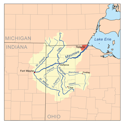
The Blanchard River is a U.S. Geological Survey. National Hydrography Dataset high-resolution flowline dataThe National Map, accessed May 19, 2011 tributary of the Auglaize River in northwestern Ohio in the United States. It drains a primarily rural farming area in the watershed of Lake Erie. It rises in central Hardin County, on the northern outskirts of Kenton. It flows generally north for its first into eastern Hancock County, where it turns sharply to the west. It flows west through Findlay and past Ottawa. It joins the Auglaize from the east in western Putnam County approximately north of Cloverdale at . History The river is named for Jean Jacques Blanchard (1720-1802), a French tailor who settled among the Shawnee along the river in 1769. Fort Findlay, an American outpost in the War of 1812, was constructed along the river in 1812 at the site of the present-day city of Findlay. In 1908, Tell Taylor wrote "Down by the Old Mill Stream", a popular song of the earl ... [...More Info...] [...Related Items...] OR: [Wikipedia] [Google] [Baidu] |
Blacklick Creek (Ohio)
Blacklick Creek is a tributary stream of Big Walnut Creek in Ohio, flowing through Licking, Fairfield and Franklin counties. The creek's name was originally given by Native Americans, who had noticed the animals that frequented the creek to lick its black-colored salt stones. It has also been known as Black Lick Creek, Black Lick Fork, Blacks Lick Creek, and Big Lick Creek. The 27 mile long rock and slate bed creek has its headwaters near Mink Street in Jersey Township, in northwestern Licking County. It enters Franklin County in northeast Plain Township and then flows near the Licking-Franklin County border. The stream enters Fairfield County in southwest Reynoldsburg, and then re-enters Franklin County near Brice. The stream meets Big Walnut Creek in Columbus, near South Hamilton Road at . Blacklick Creek topped a levee on September 14, 1979, due to heavy rains from Hurricane Frederic. The creek flooded the Municipal Building in Reynoldsburg, and three hundred homes in ... [...More Info...] [...Related Items...] OR: [Wikipedia] [Google] [Baidu] |
Black River (Ohio)
The Black River is a tributary of Lake Erie, about 12 mi (19 km) long, in northern Ohio in the United States.Columbia Gazetteer of North America entry Via Lake Erie, the Niagara River and , it is part of the watershed of the , which flows to the |
Black Fork Mohican River
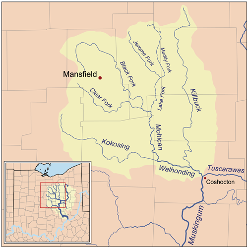
The Black Fork is a principal tributary of the Mohican River, long,Ohio Department of Natural Resources''A Guide to Ohio Streams.'' in north-central Ohio in the United States. Via the Mohican, Walhonding, Muskingum and Ohio Rivers, it is part of the watershed of the Mississippi River, draining an area of . According to the Geographic Names Information System, it has also been known historically as "Armstrongs Creek" and "Black Fork Creek". The Black Fork rises about west of Mansfield in Richland County, and initially flows northward through the city of Shelby, then eastward across northern Richland County before turning southeast for the remainder of its course through eastern Richland and southern Ashland Counties, past the towns of Perrysville and Loudonville. It joins the Clear Fork in Ashland County to form the Mohican River, about southwest of Loudonville.DeLorme (1991). ''Ohio Atlas & Gazetteer''. Yarmouth, Maine: DeLorme. . A U.S. Army Corps of Engineers ... [...More Info...] [...Related Items...] OR: [Wikipedia] [Google] [Baidu] |
Big Walnut Creek
Big Walnut Creek starts near Mount Gilead, Ohio in Morrow County. It flows south to eastern Delaware County and parallels Alum Creek. It passes to the east of Sunbury and into Hoover Reservoir, which then crosses into Franklin County. From the dam outflow in Westerville the creek flows through Gahanna and Whitehall. Near Obetz it is joined by its principal tributaries Alum Creek and Blacklick Creek at the Three Creeks Columbus Metro Park. It flows through southern Franklin County and joins the Scioto River near the Franklin-Pickaway Counties line at . Name Big Walnut Creek was named for black walnut trees which once grew in old-growth forests near the stream. According to the Geographic Names Information System, the Big Walnut Creek has also been known as: *Big Belly Creek *Big Bellys Creek *Big Lick Creek *Gahanna River *Hayes Ditch *Walnut Creek *Whingwy Mahoni Sepung *Menkwi Mhoani Siipunk See also *List of rivers of Ohio Ohio is a Midwestern state in the Great ... [...More Info...] [...Related Items...] OR: [Wikipedia] [Google] [Baidu] |
Big Darby Creek
Big Darby Creek is a scenic river located in northwestern central Ohio, and an important tributary to the Lower Scioto River. The river's major tributary is the Little Darby Creek. The river runs from its source near the Champaign-Union county line, south-east through Union and Madison Counties. In Franklin County, the river runs through the Battelle Darby Creek Metro Park, where it meets with the Little Darby Creek.Franklin County Metro ParksBattelle Darby Creek Metro Park/ref> Directly downstream from the park, the river empties into the Scioto River in Pickaway County at . Big Darby Creek is one of the most biologically diverse aquatic systems in the Midwestern United States.The Nature ConservancyDarby Creek Watershed It is the site of the only known population of the Scioto madtom, a fish which is now thought to be extinct.USFWS''Noturus trautmani'' Five-year Review.December 2009. In addition, for its size the creek "has the greatest diversity of freshwater mussels i ... [...More Info...] [...Related Items...] OR: [Wikipedia] [Google] [Baidu] |
Big Creek (Geauga County, Ohio)
Big Creek is a tributary of the Grand River and flows through Lake and Geauga counties in Ohio. It rises in glacial till near Chardon, Ohio, and cuts through the Defiance Moraine on its way north and exposes rock formations from the Paleozoic Era, including the fossiliferous Chagrin Shale. It joins the Grand River in Painesville Township in Helen Hazen Wyman Park. With a watershed of its tributaries include Cutts, Jenks, Aylworth, East, Gordon and Kellogg Creeks. It has previously been known as Bigg Creek, and West Creek. Big Creek flows through a number of parks, and is known for its fishing of smallmouth bass, and steelhead trout that spawn in the creek. History Although now an area for recreation including hiking, fishing and camping the Big Creek valley was once a place of industrial activity with saw mills, iron furnaces and a leather tannery. One of the mills was owned by Eber Howe a local newspaper editor and abolitionist, who used the mill as a "station" on the Unde ... [...More Info...] [...Related Items...] OR: [Wikipedia] [Google] [Baidu] |
Beaver Creek (Raccoon Creek Tributary)
Beaver Creek is a stream in the U.S. state of Ohio. It is a tributary of Raccoon Creek. Beaver Creek was named for the beaver dams along its course. See also *List of rivers of Ohio Ohio is a Midwestern state in the Great Lakes region of the United States. The state takes its name from the Ohio River, whose name in turn originated from the Seneca word '' ohiːyo, meaning "good river", "great river" or "large creek". The Ohio ... References Rivers of Gallia County, Ohio Rivers of Ohio {{Ohio-river-stub ... [...More Info...] [...Related Items...] OR: [Wikipedia] [Google] [Baidu] |


