|
Kingdom Of Rheged
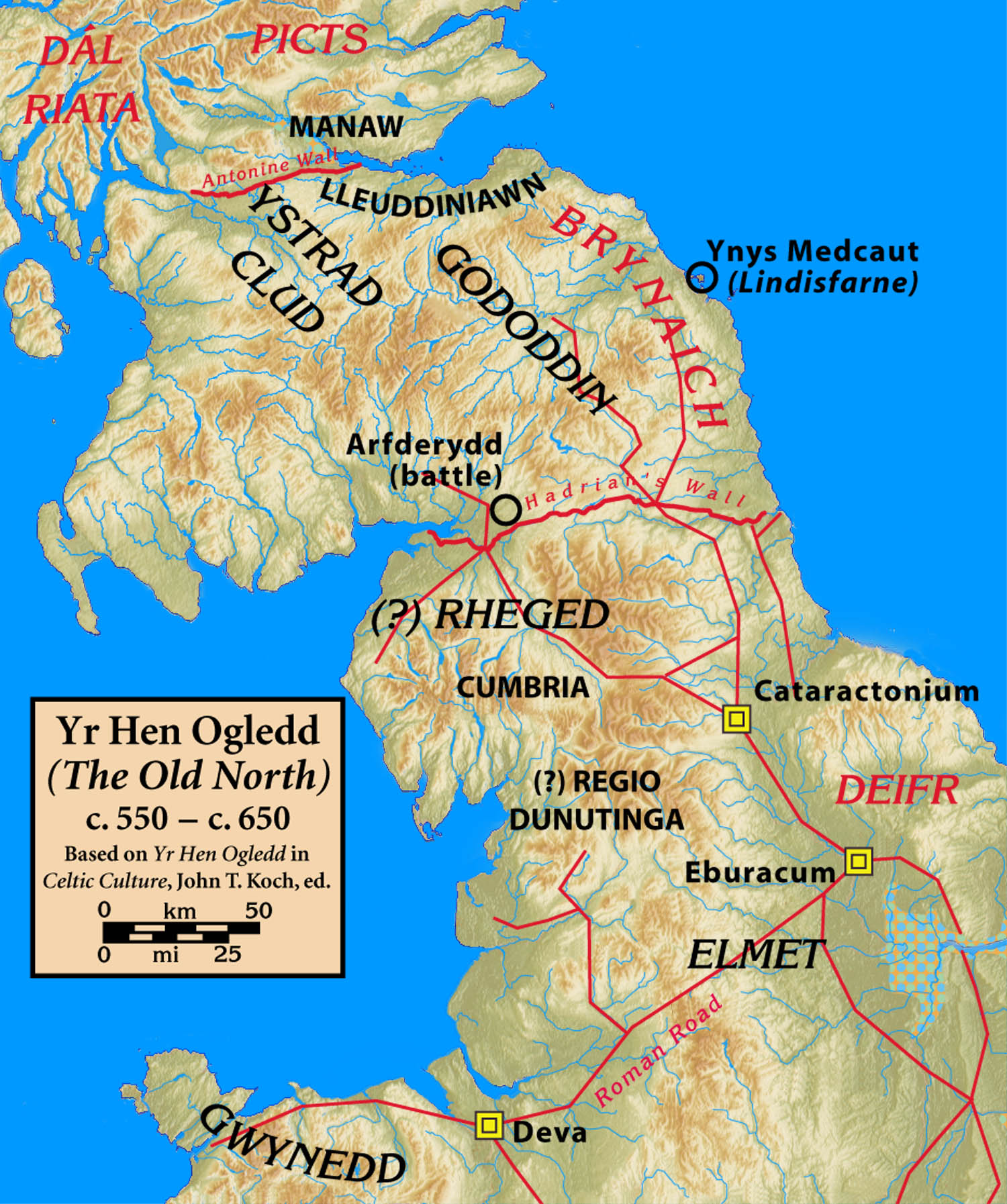
Rheged () was one of the kingdoms of the ''Hen Ogledd'' ("Old North"), the Brittonic-speaking region of what is now Northern England and southern Scotland, during the post-Roman era and Early Middle Ages. It is recorded in several poetic and bardic sources, although its borders are not described in any of them. A recent archaeological discovery suggests that its stronghold was located in what is now Galloway in Scotland rather than, as was previously speculated, being in Cumbria. Rheged possibly extended into Lancashire and other parts of northern England. In some sources, Rheged is intimately associated with the king Urien Rheged and his family. Its inhabitants spoke Cumbric, a Brittonic dialect closely related to Old Welsh. Etymology The origin of the name ''Rheged'' has been described as "problematic". One Brittonic-language solution is that the name may be a compound of ''rö-'', a prefix meaning "great", and ''cę:d'' meaning "wood, forest" (c.f. Welsh ''coed'') although ... [...More Info...] [...Related Items...] OR: [Wikipedia] [Google] [Baidu] |
Angles
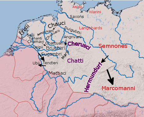
The Angles ( ang, Ængle, ; la, Angli) were one of the main Germanic peoples who settled in Great Britain in the post-Roman period. They founded several kingdoms of the Heptarchy in Anglo-Saxon England. Their name is the root of the name ''England'' ("land of Ængle"). According to Tacitus, writing around 100 AD, a people known as Angles (Anglii) lived east of the Langobards and Semnones, who lived near the Elbe river. Etymology The name of the Angles may have been first recorded in Latinised form, as ''Anglii'', in the ''Germania'' of Tacitus. It is thought to derive from the name of the area they originally inhabited, the Anglia Peninsula (''Angeln'' in modern German, ''Angel'' in Danish). Multiple theories concerning the etymology of the name have been hypothesised: # According to Gesta Danorum Dan and Angul (Angel) were made rulers by the consent of their people because of their bravery. Dan gave name to Danes and Angel gave names to Angles. # It originated from ... [...More Info...] [...Related Items...] OR: [Wikipedia] [Google] [Baidu] |
Vitrified Fort
Vitrified forts are stone enclosures whose walls have been subjected to vitrification through heat. It was long thought that these structures were unique to Scotland, but they have since been identified in several other parts of western and northern Europe. Vitrified forts are generally situated on hills offering strong defensive positions. Their form seems to have been determined by the contour of the flat summits which they enclose. The walls vary in size, a few being upwards of high, and are so broad that they present the appearance of embankments. Weak parts of the defence are strengthened by double or triple walls, and occasionally vast lines of ramparts, composed of large blocks of unhewn and unvitrified stones, envelop the vitrified centre at some distance from it. The walls themselves are termed vitrified ramparts. No lime or cement has been found in any of these structures, all of them presenting the peculiarity of being more or less consolidated by the fusion of the ro ... [...More Info...] [...Related Items...] OR: [Wikipedia] [Google] [Baidu] |
Trusty's Hill
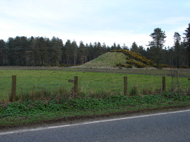
Trusty's Hill is a small vitrified hillfort about a mile to the west of the present-day town of Gatehouse of Fleet, in the parish of Anwoth in the Stewartry district of Dumfries and Galloway. The site is notable for a carved Pictish stone located near the entrance to the fort, one of only a handful of such stones found outside the core Pictish heartland of North-East Scotland. Recent (2012) archaeological investigation has also found evidence of feasting and high-status metalworking at the site, and what has been interpreted as a constructed ceremonial processional route. Together these have led to speculation that the site might have been an important centre or location of royal inaugurations for a Brythonic kingdom centred in Galloway and South-West Scotland, circa 600 AD — perhaps to be identified with the elusive north British kingdom of Rheged, which gained greatest prominence under its legendary leader Urien at a similar time in the late 6th century before apparently utte ... [...More Info...] [...Related Items...] OR: [Wikipedia] [Google] [Baidu] |
Dumfries And Galloway
Dumfries and Galloway ( sco, Dumfries an Gallowa; gd, Dùn Phrìs is Gall-Ghaidhealaibh) is one of 32 unitary council areas of Scotland and is located in the western Southern Uplands. It covers the counties of Scotland, historic counties of Dumfriesshire, Kirkcudbrightshire, and Wigtownshire, the latter two of which are collectively known as Galloway. The administrative centre and largest settlement is the town of Dumfries. The second largest town is Stranraer, on the North Channel (Great Britain and Ireland), North Channel coast, some to the west of Dumfries. Following the 1975 reorganisation of local government in Scotland, the three counties were joined to form a single regions and districts of Scotland, region of Dumfries and Galloway, with four districts within it. The districts were abolished in 1996, since when Dumfries and Galloway has been a unitary local authority. For lieutenancy areas of Scotland, lieutenancy purposes, the area is divided into three lieutenancy a ... [...More Info...] [...Related Items...] OR: [Wikipedia] [Google] [Baidu] |
Dunragit
Dunragit ( gd, Dùn Reicheit) is a village on the A75 road, A75, between Stranraer and Glenluce in Dumfries and Galloway, south-west Scotland. Dunragit is within the parish of Old Luce, in the traditional county of Wigtownshire. The modern village grew up around the west gate of Dunragit House, an 18th-century country house, though there is evidence of Neolithic settlement in the area. Toponymy The place-name Dunragit is said to derive from ''Din Rheged'' meaning "Fort of Rheged", referring to the Britons (historical), Brythonic kingdom of Rheged which existed in northern Britain between the 5th and 8th centuries. RE Dunragit monument complex Between 1999 and 2002, archeological excavations have explored the Dunragit area, and a complex of Neolithic British Isles, Neolithic monuments has been uncovered. Nothing can now be seen above ground, but aerial photography and excavation has revealed an early Neolithic cursus monument, and the remains of three later Neolithic concentric t ... [...More Info...] [...Related Items...] OR: [Wikipedia] [Google] [Baidu] |
Toponymy
Toponymy, toponymics, or toponomastics is the study of ''toponyms'' (proper names of places, also known as place names and geographic names), including their origins, meanings, usage and types. Toponym is the general term for a proper name of any geographical feature, and full scope of the term also includes proper names of all cosmographical features. In a more specific sense, the term ''toponymy'' refers to an inventory of toponyms, while the discipline researching such names is referred to as ''toponymics'' or ''toponomastics''. Toponymy is a branch of onomastics, the study of proper names of all kinds. A person who studies toponymy is called ''toponymist''. Etymology The term toponymy come from grc, τόπος / , 'place', and / , 'name'. The ''Oxford English Dictionary'' records ''toponymy'' (meaning "place name") first appearing in English in 1876. Since then, ''toponym'' has come to replace the term ''place-name'' in professional discourse among geographers. Toponym ... [...More Info...] [...Related Items...] OR: [Wikipedia] [Google] [Baidu] |
Luguvalium
Luguvalium was a Roman town in northern Britain in antiquity. It was located within present-day Carlisle, Cumbria, and may have been the capital of the 4th-century province of Valentia. Name The Romans called the settlement at what is today Carlisle . This was originally thought to mean "walld townof Lugus" but has since been explained as a borrowed Brittonic placename reconstructed as *Luguwalion, meaning " ityof Luguwalos", Luguwalos being a masculine Celtic given name meaning "strength of Lugus". The name apparently continued in use among Brythonic speakers in the Hen Ogledd and Wales and it was during that time that the initial element ''caer'' ("fort") was added. The place is mentioned in Welsh sources such as Nennius, who calls it ,Ford, David Nash.The 28 Cities of Britain" at Britannia. 2000. and the ''Book of Taliesin'' where it is rendered (Modern Welsh '). (These derived from the original Brittonic name, rather than from its Latin form.) The earliest record of the p ... [...More Info...] [...Related Items...] OR: [Wikipedia] [Google] [Baidu] |
Roman Britain
Roman Britain was the period in classical antiquity when large parts of the island of Great Britain were under occupation by the Roman Empire. The occupation lasted from AD 43 to AD 410. During that time, the territory conquered was raised to the status of a Roman province. Julius Caesar invaded Britain in 55 and 54 BC as part of his Gallic Wars. According to Caesar, the Britons had been overrun or culturally assimilated by other Celtic tribes during the British Iron Age and had been aiding Caesar's enemies. He received tribute, installed the friendly king Mandubracius over the Trinovantes, and returned to Gaul. Planned invasions under Augustus were called off in 34, 27, and 25 BC. In 40 AD, Caligula assembled 200,000 men at the Channel on the continent, only to have them gather seashells ('' musculi'') according to Suetonius, perhaps as a symbolic gesture to proclaim Caligula's victory over the sea. Three years later, Claudius directed four legi ... [...More Info...] [...Related Items...] OR: [Wikipedia] [Google] [Baidu] |
Carlisle, Cumbria
Carlisle ( , ; from xcb, Caer Luel) is a city that lies within the Northern English county of Cumbria, south of the Scottish border at the confluence of the rivers Eden, Caldew and Petteril. It is the administrative centre of the City of Carlisle district which, (along with Cumbria County Council) will be replaced by Cumberland Council in April 2023. The city became an established settlement during the Roman Empire to serve forts on Hadrian's Wall. During the Middle Ages, the city was an important military stronghold due to its proximity to the Kingdom of Scotland. Carlisle Castle, still relatively intact, was built in 1092 by William Rufus, served as a prison for Mary, Queen of Scots in 1568 and now houses the Duke of Lancaster's Regiment and the Border Regiment Museum. In the early 12th century, Henry I allowed a priory to be built. The priory gained cathedral status with a diocese in 1133, the city status rules at the time meant the settlement became a city. Fro ... [...More Info...] [...Related Items...] OR: [Wikipedia] [Google] [Baidu] |
River Lyvennet
The River Lyvennet is a river flowing through the county of Cumbria in England. The source of the Lyvennet (as Lyvennet Beck) is to be found close to Robin Hood's Grave on Crosby Ravensworth Moor, an area rich in ancient remains. From there, the beck flows northwards through Crosby Ravensworth, Mauld's Meaburn and King's Meaburn, emerging as the River Lyvennet. The river is joined by the River Leith shortly before the Lyvennet's own confluence with the River Eden. Several Pedigree cattle herds are named after the river including Lyvennet Simmentals of Greystone House, King's Meaburn. The Lyvennet valley may preserve the name of Taliesin's "Llwyfenydd" Hogg, A. H. A. (1946) 'Llwyfenydd', Antiquity, (80), pp. 210–11 and would thus be associated with the post-Roman Brythonic kingdom of Rheged Rheged () was one of the kingdoms of the ''Hen Ogledd'' ("Old North"), the Brittonic-speaking region of what is now Northern England and southern Scotland, during the post-Roman ... [...More Info...] [...Related Items...] OR: [Wikipedia] [Google] [Baidu] |
Westmorland
Westmorland (, formerly also spelt ''Westmoreland'';R. Wilkinson The British Isles, Sheet The British IslesVision of Britain/ref> is a historic county in North West England spanning the southern Lake District and the northern Dales. It had an administrative function from the 12th century until 1974. Between 1974 and 2023 Westmorland lay within the administrative county of Cumbria. In April 2023, Cumbria County Council will be abolished and replaced with two unitary authorities, one of which, Westmorland and Furness, will cover all of Westmorland (as well as other areas), thereby restoring the Westmorland name to a top-tier administrative entity. The people of Westmorland are known as Westmerians. Early history Background At the beginning of the 10th century a large part of modern day Cumbria was part of the Kingdom of Strathclyde, and was known as '' "Scottish Cumberland" ''. The Rere Cross was ordered by Edmund I (r.939-946) to serve as a boundary marker between England an ... [...More Info...] [...Related Items...] OR: [Wikipedia] [Google] [Baidu] |


