|
Causeway
A causeway is a track, road or railway on the upper point of an embankment across "a low, or wet place, or piece of water". It can be constructed of earth, masonry, wood, or concrete. One of the earliest known wooden causeways is the Sweet Track in the Somerset Levels, England, which dates from the Neolithic age. Timber causeways may also be described as both boardwalks and bridges. Etymology When first used, the word ''causeway'' appeared in a form such as "causey way" making clear its derivation from the earlier form "causey". This word seems to have come from the same source by two different routes. It derives ultimately, from the Latin for heel, ''calx'', and most likely comes from the trampling technique to consolidate earthworks. Originally, the construction of a causeway utilised earth that had been trodden upon to compact and harden it as much as possible, one layer at a time, often by enslaved bodies or flocks of sheep. Today, this work is done by machines. ... [...More Info...] [...Related Items...] OR: [Wikipedia] [Google] [Baidu] |
Hindenburgdamm
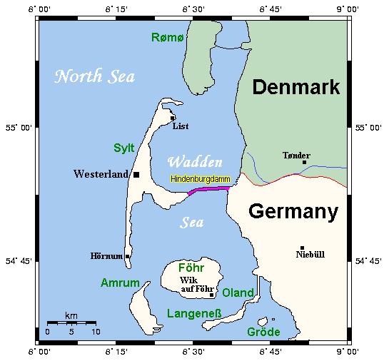
The Hindenburgdamm or Hindenburg Dam is an 11 km-long causeway joining the North Frisian island of Sylt to mainland Schleswig-Holstein. Its coordinates are . It was opened on 1 June 1927 and is exclusively a railway corridor. The companies that built the Hindenburgdamm, a job that took four years, were Philipp Holzmann AG of Frankfurt, working from the mainland, and Peter Fix Söhne of Duisburg working from Sylt. A train trip along the causeway takes about 10 minutes, and the time between the auto terminals at Niebüll on the mainland and Westerland on Sylt is about 30 minutes. The Hindenburgdamm is part of the railway line known as the ''Marschbahn'' ("Marsh Railway"), which is double-tracked along much of the route, although there as yet exists a single-tracked stretch. On the causeway is a signal box. The rail line is not electrified making the use of diesel locomotives necessary. Trains coming from origins further south like Hamburg change from an electric locomotiv ... [...More Info...] [...Related Items...] OR: [Wikipedia] [Google] [Baidu] |
Causewayed Enclosure
A causewayed enclosure is a type of large prehistoric earthwork common to the early Neolithic in Europe. It is an enclosure marked out by ditches and banks, with a number of causeways crossing the ditches. More than 100 examples are recorded in France and 70 in England, while further sites are known in Scandinavia, Belgium, Germany, Italy, Ireland and Slovakia. The term "causewayed enclosure" is now preferred to the older term, causewayed camp, as it has been demonstrated that the sites did not necessarily serve as occupation sites. Construction Causewayed enclosures are often located on hilltop sites, encircled by one to four concentric ditches with an internal bank. Enclosures located in lowland areas are generally larger than hilltop ones. Crossing the ditches at intervals are causeways which give the monuments their names. It appears that the ditches were excavated in sections, leaving the wide causeways intact in between. They should not be confused with seg ... [...More Info...] [...Related Items...] OR: [Wikipedia] [Google] [Baidu] |
Somerset Levels
The Somerset Levels are a coastal plain and wetland area of Somerset, England, running south from the Mendips to the Blackdown Hills. The Somerset Levels have an area of about and are bisected by the Polden Hills; the areas to the south are drained by the River Parrett, and the areas to the north by the rivers Axe and Brue. The Mendip Hills separate the Somerset Levels from the North Somerset Levels. The Somerset Levels consist of marine clay "levels" along the coast and inland peat-based "moors"; agriculturally, about 70 per cent is used as grassland and the rest is arable. Willow and teazel are grown commercially and peat is extracted. A Palaeolithic flint tool found in West Sedgemoor is the earliest indication of human presence in the area. The Neolithic people exploited the reed swamps for their natural resources and started to construct wooden trackways, including the world's oldest known timber trackway, the Post Track, dating from about 3800 BC. The Levels were ... [...More Info...] [...Related Items...] OR: [Wikipedia] [Google] [Baidu] |
Tenochtitlan
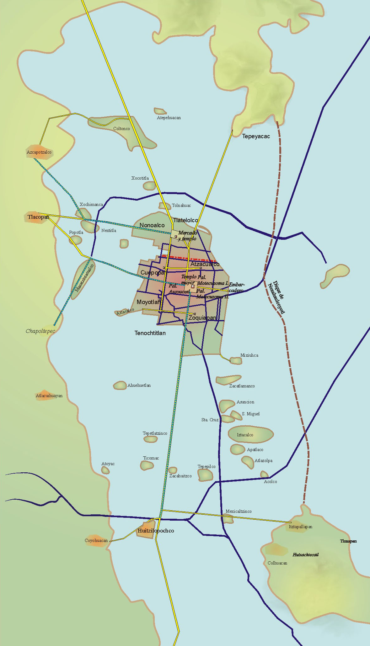
, ; es, Tenochtitlan also known as Mexico-Tenochtitlan, ; es, México-Tenochtitlan was a large Mexican in what is now the historic center of Mexico City. The exact date of the founding of the city is unclear. The date 13 March 1325 was chosen in 1925 to celebrate the 600th anniversary of the city. The city was built on an island in what was then Lake Texcoco in the Valley of Mexico. The city was the capital of the expanding Aztec Empire in the 15th century until it was captured by the Spanish in 1521. At its peak, it was the largest city in the pre-Columbian Americas. It subsequently became a '' cabecera'' of the Viceroyalty of New Spain. Today, the ruins of are in the historic center of the Mexican capital. The World Heritage Site of contains what remains of the geography (water, boats, floating gardens) of the Mexica capital. was one of two Mexica (city-states or polities) on the island, the other being . The city is located in modern-day Mexico City. E ... [...More Info...] [...Related Items...] OR: [Wikipedia] [Google] [Baidu] |
Sylt
Sylt (; da, Sild; Söl'ring North Frisian: ) is an island in northern Germany, part of Nordfriesland district, Schleswig-Holstein, and well known for the distinctive shape of its shoreline. It belongs to the North Frisian Islands and is the largest island in North Frisia. The northernmost island of Germany, it is known for its tourist resorts, notably Westerland, Kampen and Wenningstedt-Braderup, as well as for its sandy beach. It is frequently covered by the media in connection with its exposed situation in the North Sea and its ongoing loss of land during storm tides. Since 1927, Sylt has been connected to the mainland by the Hindenburgdamm causeway. In later years, it has been a resort for the German jet set and tourists in search of occasional celebrity sightings. Geography With , Sylt is the fourth-largest German island and the largest German island in the North Sea. Sylt is located from off the mainland, to which it is connected by the Hindenburgdamm. Southeast ... [...More Info...] [...Related Items...] OR: [Wikipedia] [Google] [Baidu] |
Timber Trackway
Historic roads (historic trails in USA and Canada) are paths or routes that have historical importance due to their use over a period of time. Examples exist from prehistoric times until the early 20th century. They include ancient trackways, long-lasting roads, important trade routes, and migration trails. Many historic routes, such as the Silk Road, the Amber Road, and the Royal Road of the Persian Empire, covered great distances and their impact on human settlements remain today. The Post Track, a prehistoric causeway in the valley of the River Brue in the Somerset Levels, England, is one of the oldest known constructed trackways and dates from around 3800 BCE. The world's oldest known paved road was constructed in Egypt some time between 2600 and 2200 BC. The Romans were the most significant road builders of the ancient world. At the peak of the Roman Empire there were more than of roads, of which over were stone-paved.Gabriel, Richard A. ''The Great Armies of Anti ... [...More Info...] [...Related Items...] OR: [Wikipedia] [Google] [Baidu] |
Neolithic
The Neolithic period, or New Stone Age, is an Old World archaeological period and the final division of the Stone Age. It saw the Neolithic Revolution, a wide-ranging set of developments that appear to have arisen independently in several parts of the world. This "Neolithic package" included the introduction of farming, domestication of animals, and change from a hunter-gatherer lifestyle to one of settlement. It began about 12,000 years ago when farming appeared in the Epipalaeolithic Near East, and later in other parts of the world. The Neolithic lasted in the Near East until the transitional period of the Chalcolithic (Copper Age) from about 6,500 years ago (4500 BC), marked by the development of metallurgy, leading up to the Bronze Age and Iron Age. In other places the Neolithic followed the Mesolithic (Middle Stone Age) and then lasted until later. In Ancient Egypt, the Neolithic lasted until the Protodynastic period, 3150 BC.Karin Sowada and Peter Grave. Egypt in ... [...More Info...] [...Related Items...] OR: [Wikipedia] [Google] [Baidu] |
Sweet Track
The Sweet Track is an ancient trackway, or causeway, in the Somerset Levels, England, named after its finder, Ray Sweet. It was built in 3807 BC (determined using dendrochronology) and is the second-oldest timber trackway discovered in the British Isles, dating to the Neolithic. It is now known that the Sweet Track was predominantly built along the course of an earlier structure, the Post Track. The track extended across the now largely drained marsh between what was then an island at Westhay and a ridge of high ground at Shapwick, a distance close to or around . The track is one of a network that once crossed the Somerset Levels. Various artifacts and prehistoric finds, including a jadeitite ceremonial axe head, have been found in the peat bogs along its length. Construction was of crossed wooden poles, driven into the waterlogged soil to support a walkway that consisted mainly of planks of oak, laid end-to-end. The track was used for a period of only around ten yea ... [...More Info...] [...Related Items...] OR: [Wikipedia] [Google] [Baidu] |
Step-stone Bridge
Stepping stones or stepstones are sets of stones arranged to form an improvised causeway that allows a pedestrian to cross a natural watercourse such as a river; or a water feature in a garden where water is allowed to flow between stone steps. Unlike bridges, stepstone crossings typically have no spans, although wood planks or stone slabs can be placed over between the stones (which serve as the piers) to improvise as low-water bridges. Although their historical origin is unknown, stepping stones, along with log bridges, are likely to have been one of the earliest forms of crossing inland bodies of water devised by humans. In traditional Japanese gardens, the term "''iso-watari''" refers to stepping stone pathways that lead across shallow parts of a pond, which work like a bridge-like slower crossing. Using ''iso-watari'' for crossing ponds, or shallow parts of streams, one can view the aquatic animals and plants around or in the pond, like carp, turtles, and waterfowls. Today, ... [...More Info...] [...Related Items...] OR: [Wikipedia] [Google] [Baidu] |
Norman Language
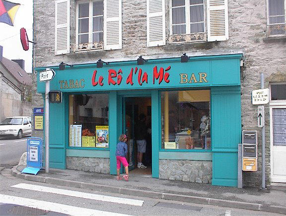
Norman or Norman French (, french: Normand, Guernésiais: , Jèrriais: ) is a Romance language which can be classified as one of the Oïl languages along with French, Picard and Walloon. The name "Norman French" is sometimes used to describe not only the Norman language, but also the administrative languages of '' Anglo-Norman'' and '' Law French'' used in England. For the most part, the written forms of Norman and modern French are mutually intelligible. This intelligibility was largely caused by the Norman language's planned adaptation to French orthography (writing). History When Norse Vikings from modern day Scandinavia arrived in Neustria, in the western part of the then Kingdom of the Franks, and settled the land that became known as Normandy, these North-Germanic–speaking people came to live among a local Gallo-Romance–speaking population. In time, the communities converged, so that ''Normandy'' continued to form the name of the region while the original No ... [...More Info...] [...Related Items...] OR: [Wikipedia] [Google] [Baidu] |
Boardwalk
A boardwalk (alternatively board walk, boarded path, or promenade) is an elevated footpath, walkway, or causeway built with wooden planks that enables pedestrians to cross wet, fragile, or marshy land. They are also in effect a low type of bridge. Such timber trackways have existed since at least Neolithic times. Some wooden boardwalks have had sections replaced by concrete and even "a type of recycled plastic that looks like wood." History An early example is the Sweet Track that Neolithic people built in the Somerset levels, England, around 6000 years ago. This track consisted mainly of planks of oak laid end-to-end, supported by crossed pegs of ash, oak, and lime, driven into the underlying peat. The Wittmoor bog trackway is the name given to each of two prehistoric plank roads, or boardwalks, trackway No. I being discovered in 1898 and trackway No. II in 1904 in the ''Wittmoor'' bog in northern Hamburg, Germany. The trackways date to the 4th and 7th century AD, bot ... [...More Info...] [...Related Items...] OR: [Wikipedia] [Google] [Baidu] |
Wadden Sea
The Wadden Sea ( nl, Waddenzee ; german: Wattenmeer; nds, Wattensee or ; da, Vadehavet; fy, Waadsee, longname=yes; frr, di Heef) is an intertidal zone in the southeastern part of the North Sea. It lies between the coast of northwestern continental Europe and the range of low-lying Frisian Islands, forming a shallow body of water with tidal flats and wetlands. It has a high biological diversity and is an important area for both breeding and migrating birds. In 2009, the Dutch and German parts of the Wadden Sea were inscribed on UNESCO's World Heritage List and the Danish part was added in June 2014. The Wadden Sea stretches from Den Helder, in the northwest of the Netherlands, past the great river estuaries of Germany to its northern boundary at Skallingen in Denmark along a total coastline of some and a total area of about . Within the Netherlands, it is bounded from the IJsselmeer by the Afsluitdijk. Historically, the coastal regions were often subjected to large floods ... [...More Info...] [...Related Items...] OR: [Wikipedia] [Google] [Baidu] |


