|
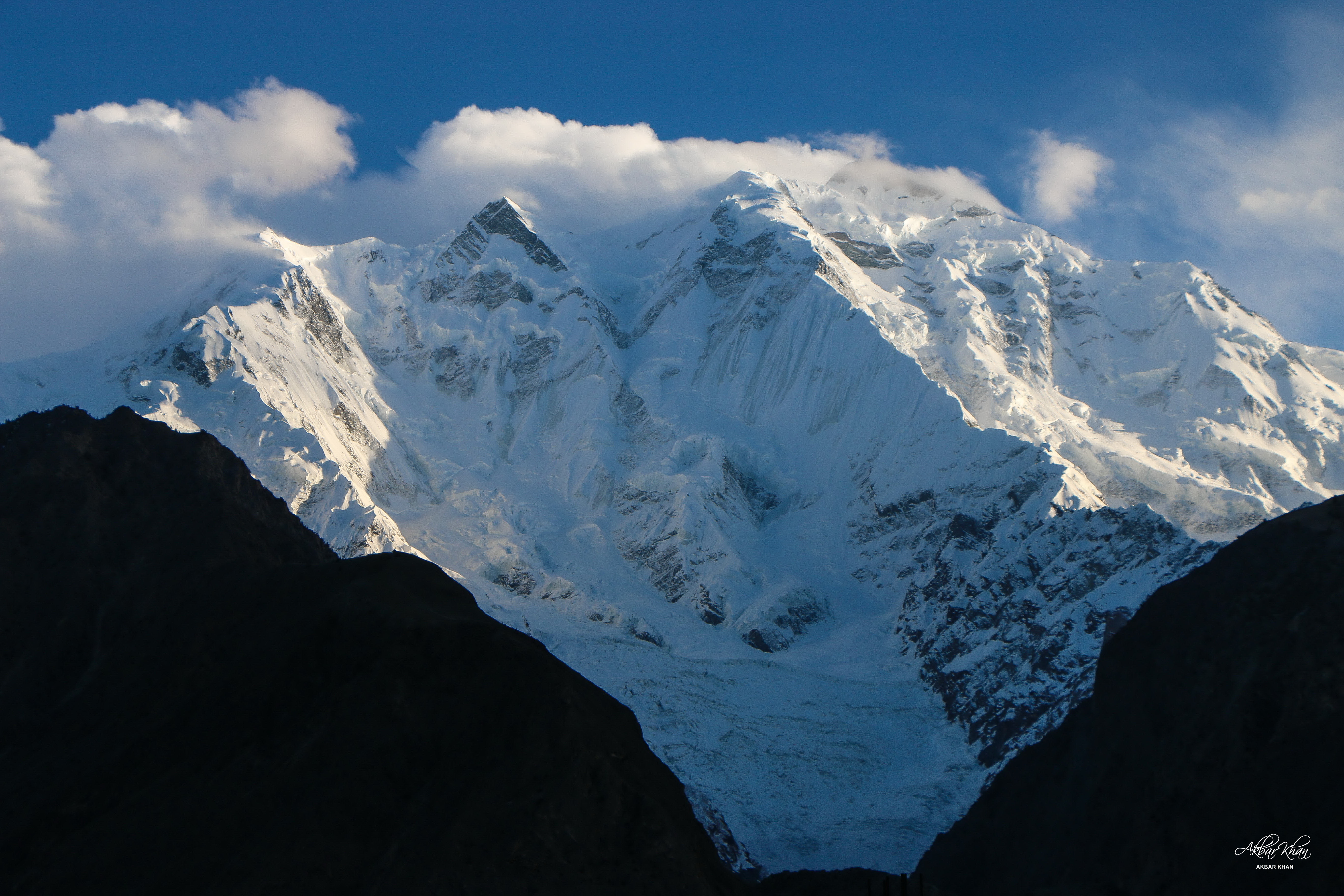
Nagar Valley
Nagar Valley is a former princely state and one of the ten districts of Gilgit Baltistan, Gilgit-Baltistan, Pakistan. The valley is along the Karakoram Highway on the way north from the city of Gilgit. The valley is home to many high mountain peaks including Rakaposhi, Rakaposhi (7788m), Diran, Diran Peak (7265m), Golden Peak and Rush Peak. The Nagar valley is administratively divided into two Tehsil, tehsils: Nagar-I and Nagar-II. All the villages of upper Nagar including Shayar, Askurdas, Sumayar, Nagarkhas, Hoper Valley, and Hispar come under Nagar-I, whereas the villages of lower Nagar including Chalt Paeen, Chalt Bala, Sonikot, Akbarabad, Rabat, Bar, Buddalas, Chaprote, Sikandarabad, Gilgit–Baltistan, Skandarabad, Jafarabad, Nilt, Thol, Ghulmet, Pisan, Minapin, Meacher, Dadhimal, Phekar, and Hakuchar are part of Nagar-II. Burushaski and Shina language, Shina languages are spoken in the valley. The Rush Lake (Pakistan), Rush Lake, the highest alpine lake of Pakistan and t ... [...More Info...] [...Related Items...] OR: [Wikipedia] [Google] [Baidu] |
Rakaposhi
Rakaposhi ( ur, ) is a mountain in the Karakoram mountain range of the Gilgit-Baltistan territory of Pakistan. Geography Rakaposhi is a mountain in the Karakoram mountain range in the Gilgit-Baltistan territory of Pakistan, about north of the city of Gilgit. It is ranked 27th-highest in the world. Rakaposhi rises over the Bagrot, Nagar, and Danyor Rakaposhi is the only mountain in the world with more than 5,000 meters height between base camp and the summit; by contrast all of the other tallest mountains in the world have less than 5,000 meters from base camp to top. The first successful recorded ascent by non-natives was in 1958 by Mike Banks and Tom Patey, members of a British expedition, via the Southwest Spur/Ridge route. Park Rakaposhi is also known as Dumani ("Mother of Mist" or "Mother of Clouds"). The people of Nagar and Bagrot Valley have dedicated the Rakaposhi range mountain area as a community park. The Minister for Northern A ... [...More Info...] [...Related Items...] OR: [Wikipedia] [Google] [Baidu] |
Gilgit-Baltistan Scouts
The Gilgit−Baltistan Scouts, are a civil armed force of Pakistan, tasked with law enforcement in the nominally autonomous territory of Gilgit-Baltistan and border guard duties. The force was formed in 2003 under the control of the Interior Ministry of Pakistan, but it claims a tradition dating back to the Gilgit Scouts formed during the British Raj era. However, the earlier Scouts unit is now a full infantry regiment of the Pakistan Army (see Northern Light Infantry Regiment, which mostly operates in the same region as the current Scouts. Formation The older Gilgit Scouts was raised by British India in 1913 to defend the princely state of Jammu and Kashmir's northern frontier. In August 1047, the Scouts along with rebels in the Jammu and Kashmir State Forces, switched allegiance to Pakistan and fought on the northern front of the Indo-Pakistani War of 1947–1948, conquering important places such as Skardu, Kargil and Drass (the latter two were subsequently recapture ... [...More Info...] [...Related Items...] OR: [Wikipedia] [Google] [Baidu] |
Nilt Forts
Nilt is a town in Gilgit District, Gilgit–Baltistan, Pakistan Pakistan ( ur, ), officially the Islamic Republic of Pakistan ( ur, , label=none), is a country in South Asia. It is the world's fifth-most populous country, with a population of almost 243 million people, and has the world's second-lar .... It is located at 36°15'0N 74°25'0E with an elevation of 2260 metres (7417 feet). This area was conquered by the British in 1891 as part of the Hunza-Nagar Campaign. References Populated places in Gilgit District {{GilgitBaltistan-geo-stub ... [...More Info...] [...Related Items...] OR: [Wikipedia] [Google] [Baidu] |
Alpine Lake
Alpine lakes are classified as lakes at high altitudes in mountainous zones, usually near or above the tree line, with extended periods of ice cover. These lakes are commonly formed from glacial activity (either current or in the past) but can also be formed from geological processes such as volcanic activity or landslides. Many alpine lakes that are fed from glacial melt have the characteristic bright turquoise or green color as a result of glacial flour, suspended minerals derived from a glacier scouring the bedrock. When active glaciers are not supplying water to the lake, such as a majority of alpine lakes of the Rocky Mountains in the U.S., the lakes may still be bright blue due to the lack of algae growth resulting from cold temperatures, lack of nutrient run-off from surrounding land, and lack of sediment input. The coloration and mountain locations of alpine lakes attract lots of recreational activity. Alpine lakes are some of the most abundant types of lakes on Earth. In ... [...More Info...] [...Related Items...] OR: [Wikipedia] [Google] [Baidu] |
Rush Lake (Pakistan)
Rush Lake ( ur, ) is a high altitude lake located in Hunza Valley, Gilgit-Baltistan, Pakistan near Rush Pari Peak. At , Rush is one of the highest alpine lakes in the world. It is located about north of Miar Peak and Spantik ( Golden Peak), which are in the Hunza Valley. It is the highest lake in Pakistan and 27th highest lake in the world. Rush Lake and Rush Peak is reached via Hunza and Hopar Valley via the Hopar Glacier (Bualtar Glacier) and Miar Glacier, which rises from Miar and Phuparash peaks. The trek to Rush Lake provides views of Spantik, Malubiting, Miar Peak, Phuparash Peak and Ultar Sar. See also * Hopar Valley * List of lakes in Pakistan References External links Trek to the highest altitude Rush Lake in Pakistan''The Nation ''The Nation'' is an American liberal biweekly magazine that covers political and cultural news, opinion, and analysis. It was founded on July 6, 1865, as a successor to William Lloyd Garrison's '' The Liberator'', an abolitionist news ... [...More Info...] [...Related Items...] OR: [Wikipedia] [Google] [Baidu] |
Shina Language
Shina ( ) is an Indo-Aryan language spoken by the Shina people. In Pakistan, Shina is the major language in Gilgit-Baltistan spoken by an estimated 1,146,000 people living mainly in Gilgit-Baltistan and Kohistan.{{Cite book , last1=Saxena , first1=Anju , url=https://books.google.com/books?id=g8DAmULPQU0C&dq=shina+gilgit+ladakh&pg=PA137 , title=Lesser-Known Languages of South Asia: Status and Policies, Case Studies and Applications of Information Technology , last2=Borin , first2=Lars , date=2008-08-22 , publisher=Walter de Gruyter , isbn=978-3-11-019778-5 , pages=137 , language=en , quote=Shina is an Indo-Aryan language of the Dardic group, spoken in the Karakorams and the western Himalayas: Gilgit, Hunza, the Astor Valley, the Tangir-Darel valleys, Chilas and Indus Kohistan, as well as in the upper Neelam Valley and Dras. Outliers of Shina are found in Ladakh (Brokskat), Chitral (Palula and Sawi), Swat (Ushojo; Bashir 2003: 878) and Dir (Kalkoti). A small community of Shina sp ... [...More Info...] [...Related Items...] OR: [Wikipedia] [Google] [Baidu] |
Burushaski
Burushaski (; ) is a language isolate spoken by Burusho people, who reside almost entirely in northern Gilgit-Baltistan, Pakistan, with a few hundred speakers in northern Jammu and Kashmir, India. In Pakistan, Burushaski is spoken by people in Hunza District, Nagar District, northern Gilgit District, the Yasin valley in the Gupis-Yasin District and the Ishkoman valley of the northern Ghizer District. Their native region is located in northern Gilgit–Baltistan and borders with the Pamir corridor to the north. In India, Burushaski is spoken in Botraj Mohalla of the Hari Parbat region in Srinagar. Other names for the language are ''Biltum'', ''Khajuna'', ''Kunjut'', ''Brushaski'', ''Burucaki'', ''Burucaski'', ''Burushaki'', ''Burushki'', ''Brugaski'', ''Brushas'', ''Werchikwar'' and ''Miśa:ski''. Classification Attempts have been made to establish links between Burushaski and several different language families, although none has been accepted by a majority of linguists. Fol ... [...More Info...] [...Related Items...] OR: [Wikipedia] [Google] [Baidu] |
Dadhimal
Dadimal is a small village in Nagar District, Pakistan Pakistan ( ur, ), officially the Islamic Republic of Pakistan ( ur, , label=none), is a country in South Asia. It is the world's fifth-most populous country, with a population of almost 243 million people, and has the world's second-lar .... It is between Fakar and Miacher. Populated places in Nagar District {{Pakistan-geo-stub ... [...More Info...] [...Related Items...] OR: [Wikipedia] [Google] [Baidu] |
Sikandarabad, Gilgit–Baltistan
Sikandarabad ( ur, سکندر آباد) is a village located in the Nagar District of Gilgit–Baltistan in Pakistan Pakistan ( ur, ), officially the Islamic Republic of Pakistan ( ur, , label=none), is a country in South Asia. It is the world's fifth-most populous country, with a population of almost 243 million people, and has the world's second-lar .... It is the headquarters of "Nagar 2" tehsil. "Sikandarabad" is located on "Karakoram Highway(KKH)". "Sikandarabad" is a mountainous area. It is along the "Karakoram range". It is near base camp of "Rakaposhi" mountain. Opposite "Skandarabad" there are the great "Himalaya range"mountains. It contains many fruit trees and also vegetables, for example, cherry, apples, peach, apricot, potatoes, and maize. It also has dry fruits trees, for example, walnut, almond, and dry apricot. Populated places in Nagar District {{GilgitBaltistan-geo-stub ... [...More Info...] [...Related Items...] OR: [Wikipedia] [Google] [Baidu] |
Chaprote
Chaprote is one of the earliest villages in the Nagar District in the Gilgit-Baltistan region. It is a scenic area, in which the literacy rate is more than 90%. The village is consist on 500 families and more then 10 tribes. Khimitay, Khanny, Masuty, Duguray and Bekhdury are well known families in the region. Many miles of terraced fields and fruit orchards mark Chaprote, the earlier capital of Nagar Valley. It offers a panoramic view of the Rakaposhi and other peaks surrounding Nagar Valley. It is about from the city of Gilgit and it takes a van about 1 hour to cover the distance. The total Area of the valley is around 8 miles. Moreover, there is a famous tourist spot which called GAPA. This tourist spot gives a mesmerizing view of Rakaposhi Peak. Chaprote is the center of a form of shamanism called “Danyalism”.Mir, Shabbir.“The little known shamans of Nagar Valley” The Express Tribune ''The Express Tribune'' is a daily English language, English-language newspape ... [...More Info...] [...Related Items...] OR: [Wikipedia] [Google] [Baidu] |
Hispar
The Hispar Valley or Hispar (Urdu.وادی ہسپر) is the last Valley of Nagar Valley in the Gilgit-Baltistan region of Pakistan. The valley is located two kilometers below the snout of the 49 kilometer-long Hispar Glacier. It is about 28 km away from Nagar Khas and 25 km away from Hoper Valley. It can be reached from the Karakoram Highway by the road that leads towards Nagar and Hopar Valley. The Hispar valley links the Nagar District to the Shigar District via Hispar Pass at the altitude of 16,824 ft. Peaks, glaciers and mountain passes Peaks * Golden Peak * Miar Peak * Malubiting * Hispar Sar Glaciers * Hispar Glacier * Biafo Glacier Mountain passes * Hispar Pass Valleys nearby * Hoper Valley *Nagarkhas *Nagar Valley * Sumayar Valley *Hunza Valley See also * Biafo Glacier * State of Nagar Nagar ( ur, , ''Riyasat Nagar'') was a princely salute state in the northern part of Gilgit–Baltistan, Pakistan. Until August 1947, it was in a subsidiary al ... [...More Info...] [...Related Items...] OR: [Wikipedia] [Google] [Baidu] |


