|
Zons
Zons (), formerly known as Feste Zons ''( Fortress Zons''), today officially called ''Stadt Zons'' (''Zons Town'') is an old town in Germany on the west bank of the Lower Rhine between Cologne and Düsseldorf. It has been a part (Stadtteil) of the town of Dormagen since 1975. In 2020 its population was 5,452. Geography The east border of Zons is the river Rhine. The river can be crossed by ferry. On the opposite bank a road leads to Düsseldorf-Urdenbach northeast of Zons. South of Zons is fields and a few Populus trees. The southern road passes two farms and leads to another part of Dormagen, Rheinfeld. West of Zons is extensive meadows with the willows here and there. At some distance the small hamlet Nachtigall lies at the Bundesstraße 9. Northwest of Zons is the Zons Heath. The northern road leads to Stürzelberg, another part of Dormagen. North of ferry slip and ship pier begins the nature reserve ''Zonser Grind'' on the western bank of the Rhine. History Middle ... [...More Info...] [...Related Items...] OR: [Wikipedia] [Google] [Baidu] |
Zons Axb02
Zons (), formerly known as Feste Zons ''( Fortress Zons''), today officially called ''Stadt Zons'' (''Zons Town'') is an old town in Germany on the west bank of the Lower Rhine between Cologne and Düsseldorf. It has been a part (Stadtteil) of the town of Dormagen since 1975. In 2020 its population was 5,452. Geography The east border of Zons is the river Rhine. The river can be crossed by ferry. On the opposite bank a road leads to Düsseldorf-Urdenbach northeast of Zons. South of Zons is fields and a few Populus trees. The southern road passes two farms and leads to another part of Dormagen, Rheinfeld. West of Zons is extensive meadows with the willows here and there. At some distance the small hamlet Nachtigall lies at the Bundesstraße 9. Northwest of Zons is the Zons Heath. The northern road leads to Stürzelberg, another part of Dormagen. North of ferry slip and ship pier begins the nature reserve ''Zonser Grind'' on the western bank of the Rhine. History Middle ... [...More Info...] [...Related Items...] OR: [Wikipedia] [Google] [Baidu] |
Neuss
Neuss (; spelled ''Neuß'' until 1968; li, Nüss ; la, Novaesium) is a city in North Rhine-Westphalia, Germany. It is located on the west bank of the Rhine opposite Düsseldorf. Neuss is the largest city within the Rhein-Kreis Neuss district. It is primarily known for its historic Roman sites, as well as the annual Neusser Bürger-Schützenfest. Neuss and Trier share the title of "Germany's oldest city"; and in 1984 Neuss celebrated the 2000th anniversary of its founding in 16 BCE. History Ancient Rome Neuss was founded by the Romans in 16 BC as a military fortification (''castrum'') with the current city to the north of the castrum, at the confluence of the rivers Rhine and Erft, with the name of Novaesium. Legio XVI Gallica ("Gallic 16th Legion") of the Roman army was stationed here in 43-70 AD. It was disbanded after surrendering during the Batavian rebellion (AD 70). Later a civil settlement was founded in the area of today's centre of the town during the 1st centur ... [...More Info...] [...Related Items...] OR: [Wikipedia] [Google] [Baidu] |
Dormagen
Dormagen (; Ripuarian: ''Dormaje'') is a town in North Rhine-Westphalia, Germany in the Rhein-Kreis Neuss. Geography Dormagen is situated between Düsseldorf – Cologne – Mönchengladbach on the western bank of the river Rhine. Division of the town Dormagen consists of 16 subdivisions (with population figure): * Broich: see Gohr * Delhoven: 3,690 * Delrath: 3,082 * Dormagen Mitte: 5,621 * Gohr: 2,217 (with Broich) * Hackenbroich (with Hackhausen): 8,689 * Hackhausen see Hackenbroich * Horrem: 6,022 * Knechtsteden: * Nievenheim (with Ückerath): 9,553 * Dormagen Nord: 3,514 * Rheinfeld: 5,403 (with Piwipp) * St. Peter: see Stürzelberg * Straberg: 2,840 * Stürzelberg: 4,643 (with St. Peter) * Zons: 5,414 (with Nachtigall) * Piwipp: 37 (Wohnmobil Parkplatz) History Dormagen was founded 50 AD. Its name was ''Durnomagus''. Economy Its main industry and employer is the chemical factory of Bayer AG and since its founding the Covestro AG. Transport The town has three stations ( ... [...More Info...] [...Related Items...] OR: [Wikipedia] [Google] [Baidu] |
Rhine
), Surselva, Graubünden, Switzerland , source1_coordinates= , source1_elevation = , source2 = Rein Posteriur/Hinterrhein , source2_location = Paradies Glacier, Graubünden, Switzerland , source2_coordinates= , source2_elevation = , source_confluence = Reichenau , source_confluence_location = Tamins, Graubünden, Switzerland , source_confluence_coordinates= , source_confluence_elevation = , mouth = North Sea , mouth_location = Netherlands , mouth_coordinates = , mouth_elevation = , progression = , river_system = , basin_size = , tributaries_left = , tributaries_right = , custom_label = , custom_data = , extra = The Rhine ; french: Rhin ; nl, Rijn ; wa, Rén ; li, Rien; rm, label= Sursilvan, Rein, rm, label= Sutsilvan and Surmiran, Ragn, rm, label=Rumantsch Grischun, Vallader and Puter, Rain; it, Reno ; gsw, Rhi(n), inclu ... [...More Info...] [...Related Items...] OR: [Wikipedia] [Google] [Baidu] |
Fortress
A fortification is a military construction or building designed for the defense of territories in warfare, and is also used to establish rule in a region during peacetime. The term is derived from Latin ''fortis'' ("strong") and ''facere'' ("to make"). From very early history to modern times, defensive walls have often been necessary for cities to survive in an ever-changing world of invasion and conquest. Some settlements in the Indus Valley civilization were the first small cities to be fortified. In ancient Greece, large stone walls had been built in Mycenaean Greece, such as the ancient site of Mycenae (famous for the huge stone blocks of its 'cyclopean' walls). A Greek ''Towns of ancient Greece#Military settlements, phrourion'' was a fortified collection of buildings used as a military garrison, and is the equivalent of the ancient Roman, Roman castellum or English language, English fortress. These constructions mainly served the purpose of a watch tower, to guard certa ... [...More Info...] [...Related Items...] OR: [Wikipedia] [Google] [Baidu] |
Lord Of The Manor
Lord of the Manor is a title that, in Anglo-Saxon England, referred to the landholder of a rural estate. The lord enjoyed manorial rights (the rights to establish and occupy a residence, known as the manor house and demesne) as well as seignory, the right to grant or draw benefit from the estate. The title continues in modern England and Wales as a legally recognised form of property that can be held independently of its historical rights. It may belong entirely to one person or be a moiety shared with other people. A title similar to such a lordship is known in French as ''Sieur'' or , in German, (Kaleagasi) in Turkish, in Norwegian and Swedish, in Welsh, in Dutch, and or in Italian. Types Historically a lord of the manor could either be a tenant-in-chief if he held a capital manor directly from the Crown, or a mesne lord if he was the vassal of another lord. The origins of the lordship of manors arose in the Anglo-Saxon system of manorialism. Following the N ... [...More Info...] [...Related Items...] OR: [Wikipedia] [Google] [Baidu] |
Merovingian
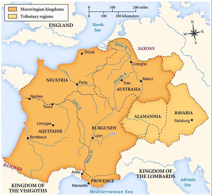
The Merovingian dynasty () was the ruling family of the Franks from the middle of the 5th century until 751. They first appear as "Kings of the Franks" in the Roman army of northern Gaul. By 509 they had united all the Franks and northern Gaulish Romans under their rule. They conquered most of Gaul, defeating the Visigoths (507) and the Burgundians (534), and also extended their rule into Raetia (537). In Germania, the Alemanni, Bavarii and Saxons accepted their lordship. The Merovingian realm was the largest and most powerful of the states of western Europe following the breaking up of the empire of Theodoric the Great. The dynastic name, medieval Latin or ("sons of Merovech"), derives from an unattested Frankish form, akin to the attested Old English , with the final -''ing'' being a typical Germanic patronymic suffix. The name derives from King Merovech, whom many legends surround. Unlike the Anglo-Saxon royal genealogies, the Merovingians never claimed descent from a ... [...More Info...] [...Related Items...] OR: [Wikipedia] [Google] [Baidu] |
Socage
Socage () was one of the feudal duties and land tenure forms in the Feudalism, English feudal system. It eventually evolved into the freehold tenure called "free and common socage", which did not involve feudal duties. Farmers held land in exchange for clearly defined, fixed payments made at specified intervals to feudal lords. The lord was therefore obligated to provide certain services, such as protection, to the farmer and other duties to the Crown. Payments usually took the form of cash, but occasionally could be made with goods. Socage contrasted with other forms of tenure, including serjeanty, frankalmoin and knight-service. The England and Wales, English statute ''Quia Emptores'' of Edward I of England, Edward I (1290) established that socage tenure passed from one generation or nominee to the next would be subject to inquisitions post mortem, which would usually involve a feudal relief tax. This contrasts with the treatment of Leasehold estate, leases, which could be lif ... [...More Info...] [...Related Items...] OR: [Wikipedia] [Google] [Baidu] |
Proprietary Church
{{Short pages monitor ... [...More Info...] [...Related Items...] OR: [Wikipedia] [Google] [Baidu] |
Altstadt
''Altstadt'' is the German language word for "old town", and generally refers to the historical town or city centre within the old town or city wall, in contrast to younger suburbs outside. '' Neustadt'' (new town), the logical opposite of ''Altstadt'', mostly stands for a part of the "''Altstadt''" in modern sense, sometimes only a few years younger than the oldest part, e. g. a late medieval enlargement. Germany Most German towns have an ''Altstadt'', even though the ravages of war have destroyed many of them, especially during the Thirty Years' War (1618–1648). Another notable example was during the Nine Years' War (1688–1697), where Mélac's aggressive tactics devastated many cities and large parts of South Western Germany, like the Heidelberg Castle. Allied strategic bombing during World War II destroyed nearly all large cities, with the exception of Regensburg and Heidelberg. Many smaller towns remained intact, for example Bamberg, Konstanz, Passau, Tübingen, Dinke ... [...More Info...] [...Related Items...] OR: [Wikipedia] [Google] [Baidu] |
Castle
A castle is a type of fortified structure built during the Middle Ages predominantly by the nobility or royalty and by military orders. Scholars debate the scope of the word ''castle'', but usually consider it to be the private fortified residence of a lord or noble. This is distinct from a palace, which is not fortified; from a fortress, which was not always a residence for royalty or nobility; from a ''pleasance'' which was a walled-in residence for nobility, but not adequately fortified; and from a fortified settlement, which was a public defence – though there are many similarities among these types of construction. Use of the term has varied over time and has also been applied to structures such as hill forts and 19th-20th century homes built to resemble castles. Over the approximately 900 years when genuine castles were built, they took on a great many forms with many different features, although some, such as curtain walls, arrowslits, and portcullises, were ... [...More Info...] [...Related Items...] OR: [Wikipedia] [Google] [Baidu] |
Topography
Topography is the study of the forms and features of land surfaces. The topography of an area may refer to the land forms and features themselves, or a description or depiction in maps. Topography is a field of geoscience and planetary science and is concerned with local detail in general, including not only relief, but also natural, artificial, and cultural features such as roads, land boundaries, and buildings. In the United States, topography often means specifically ''relief'', even though the USGS topographic maps record not just elevation contours, but also roads, populated places, structures, land boundaries, and so on. Topography in a narrow sense involves the recording of relief or terrain, the three-dimensional quality of the surface, and the identification of specific landforms; this is also known as geomorphometry. In modern usage, this involves generation of elevation data in digital form (DEM). It is often considered to include the graphic representation of t ... [...More Info...] [...Related Items...] OR: [Wikipedia] [Google] [Baidu] |


