|
Ytyk-Kyuyol
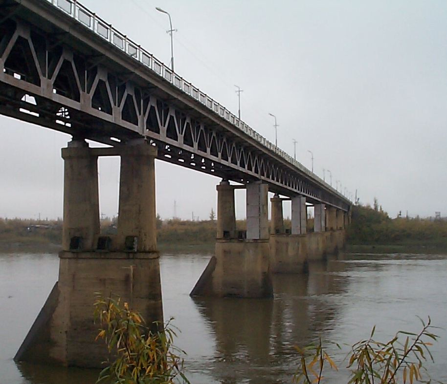
Ytyk-Kyuyol (russian: Ытык-Кюёль; sah, Ытык-Күөл, ''Itık Küöl'') is a rural locality (a '' selo'') and the administrative center of Tattinsky District of the Sakha Republic, Russia,''Registry of the Administrative-Territorial Divisions of the Sakha Republic'' located on the left bank of the Tatta River (in the Aldan's basin), from Yakutsk, the capital of the republic. As of the 2010 Census, its population was 6,828. Etymology It is named for a nearby lake, whose name literally means "sacred lake" in the Yakut language. History Ytyk-Kyuyol became the administrative center of the newly created Alexeyevsky District in 1930. The district was given its present name (after the Tatta River) in 1990. Ytyk-Kyuyol is often affected by flooding, most recently on May 20, 2007, when 873 houses were submerged and more than 3,000 people had to be evacuated. Economy An agricultural center, Ytyk-Kyuyol has developed cattle and horse breeding industries; gr ... [...More Info...] [...Related Items...] OR: [Wikipedia] [Google] [Baidu] |
Tattinsky District
Tattinsky District (russian: Таттинский улу́с; sah, Таатта улууһа, ''Taatta uluuha'') is an administrativeConstitution of the Sakha Republic and municipalLaw #172-Z #351-III district (raion, or ''ulus''), one of the thirty-four in the Sakha Republic, Russia. It is located in the eastern central part of the republic and borders with Tomponsky District in the north and east, Ust-Maysky District in the south, Churapchinsky District in the southwest, and with Ust-Aldansky District in the northwest. The area of the district is .Registry of the Administrative-Territorial Divisions of the Sakha Republic Its administrative center is the rural locality (a '' selo'') of Ytyk-Kyuyol. Population: 16,601 ( 2002 Census); The population of Ytyk-Kyuyol accounts for 39.6% of the district's total population. Geography The landscape of the district is mostly flat. Its main rivers include the Amga, the Aldan and the Tatta, a tributary of the latter. Climate Average Janua ... [...More Info...] [...Related Items...] OR: [Wikipedia] [Google] [Baidu] |
Tatta
, image = Ытык-Кюель1.jpg , image_caption = A branch of the Tatta at Ytyk-Kyuyol , source1 = Lena Plateau , source1_elevation = , source1_coordinates = , mouth = Aldan River , mouth_elevation = , mouth_coordinates = , progression = , subdivision_type1 = Country , subdivision_name1 = Russian Federation , length = , discharge1_avg = (middle) , basin_size = , pushpin_map = Russia Sakha Republic , pushpin_map_size = , pushpin_map_caption= Mouth location in Yakutia, Russia The Tatta (russian: Татта; sah, Таатта) is a river in the Sakha Republic (Yakutia), Russia, a left tributary of the Aldan, part of the Lena basin. The Tatta has a length of and a drainage basin area of . There are many inhabited places close to the banks of the Tatta, especially in its upper and middle reaches, including Churapcha and Ytyk-Kyuyol towns, as well as Uolba, Bulun, Tattinsky ... [...More Info...] [...Related Items...] OR: [Wikipedia] [Google] [Baidu] |
Sakha Republic
Sakha, officially the Republic of Sakha (Yakutia),, is the largest republic of Russia, located in the Russian Far East, along the Arctic Ocean, with a population of roughly 1 million. Sakha comprises half of the area of its governing Far Eastern Federal District, and is the world's largest country subdivision, covering over 3,083,523 square kilometers (1,190,555 sq mi). ''Sakha'' following regular sound changes in the course of development of the Yakut language) as the Evenk and Yukaghir exonyms for the Yakuts. It is pronounced as ''Haka'' by the Dolgans, whose language is either a dialect or a close relative of the Yakut language.Victor P. Krivonogov, "The Dolgans’Ethnic Identity and Language Processes." ''Journal of Siberian Federal University'', Humanities & Social Sciences 6 (2013 6) 870–888. Geography * ''Borders'': ** ''internal'': Chukotka Autonomous Okrug (660 km)(E), Magadan Oblast (1520 km)(E/SE), Khabarovsk Krai (2130 km)(SE), Amur Oblast (S ... [...More Info...] [...Related Items...] OR: [Wikipedia] [Google] [Baidu] |
Soviet Census (1979)
In January 1979, the Soviet Union conducted its first census in nine years (since 1970). Between 1970 and 1979, the total Soviet population increased from 241,720,134 to 262,084,654, an increase of 8.4%. Summary As in 1970, Russians, Ukrainians, Uzbeks, and Belarusians were the largest ethnic groups in the Soviet Union in 1979. Specifically, there were 137,397,089 Russians, 42,347,387 Ukrainians, 12,455,978 Uzbeks, and 9,462,715 Belarusians living in the Soviet Union in 1979. Meanwhile, the largest SSRs in the Soviet Union by population in 1979 were the Russian SFSR (with 137.6 million inhabitants), the Ukrainian SSR (with 49.8 million inhabitants), the Uzbek SSR (with 15.4 million inhabitants), the Russian-plurality Kazakh SSR (with 14.7 million inhabitants), and the Byelorussian SSR (with 9.6 million inhabitants). The Tajik SSR, Uzbek SSR, and Turkmen SSRs were the fastest-growing SSRs between 1970 and 1979. During this time, the Tajik SSR grew by 31% while the Uzbek SSR gre ... [...More Info...] [...Related Items...] OR: [Wikipedia] [Google] [Baidu] |
Soviet Census (1989)
The 1989 Soviet census (russian: Всесоюзная перепись населения 1989, lit=1989 All-Union Census), conducted between 12 and 19 January of that year, was the last one that took place in the Soviet Union. The census found the total population to be 286,730,819 inhabitants. In 1989, the Soviet Union ranked as the third most populous in the world, above the United States (with 248,709,873 inhabitants according to the 1990 census), although it was well below China and India. Statistics In 1989, about half of the Soviet Union's total population lived in the Russian SFSR, and approximately one-sixth (18%) of them in the Ukrainian SSR. Almost two-thirds (65.7%) of the population was urban, leaving the rural population with 34.3%.Encyclopædia Britannica Book of the Year 1991, Soviet Union, page 720. In this way, its gradual increase continued, as shown by the series represented by 47.9%, 56.3% and 62.3% of 1959, 1970 and 1979, respectively. [...More Info...] [...Related Items...] OR: [Wikipedia] [Google] [Baidu] |
Russian Census (2002)
The Russian Census of 2002 (russian: Всеросси́йская пе́репись населе́ния 2002 го́да) was the first census of the Russian Federation since the dissolution of the Soviet Union, carried out on October 9 through October 16, 2002. It was carried out by the Russian Federal Service of State Statistics (Rosstat). Data collection The census data were collected as of midnight October 9, 2002. Resident population The census was primarily intended to collect statistical information about the resident population of Russian Federation. The resident population included: * Russian citizens living in Russia (including those temporarily away from the country, provided the absence from the country was expected to last less than one year); * non-citizens (i.e. foreign citizens and stateless persons) who were any of the following: ** legal permanent residents; ** persons who have arrived in the country with the intent to settle permanently or to seek asylum, regar ... [...More Info...] [...Related Items...] OR: [Wikipedia] [Google] [Baidu] |
R504 Kolyma Highway
The R504 Kolyma Highway (russian: Федеральная автомобильная дорога «Колыма», ''Federal'naya Avtomobil'naya Doroga «Kolyma»,'' "Federal Automobile Highway 'Kolyma'"), part of the M56 route, is a road through the Russian Far East. It connects Magadan with the town of Nizhny Bestyakh, located on the eastern bank of Lena River, opposite of Yakutsk. At Nizhny Bestyakh the Kolyma Highway connects to the Lena Highway. The Kolyma Highway is colloquially known as the Road of Bones (Russian: Дорога Костей, transliteration: ''Doróga Kostyéy''), in reference to the hundreds of thousands of forced laborers who were interred in the pavement after dying during its construction. Locally, the road is known as the Kolyma Route (Russian: Колымская трасса, transliteration: ''Kolýmskaya trássa''). History The Dalstroy construction directorate built the Kolyma Highway during the Soviet Union's Stalinist era. Inmates of the ... [...More Info...] [...Related Items...] OR: [Wikipedia] [Google] [Baidu] |
Yakut Language
Yakut , also known as Yakutian, Sakha, Saqa or Saxa ( sah, саха тыла), is a Turkic language spoken by around 450,000 native speakers, primarily the ethnic Yakuts and one of the official languages of Sakha (Yakutia), a federal republic in the Russian Federation. The Yakut language differs from all other Turkic languages in the presence of a layer of vocabulary of unclear origin (possibly Paleo-Siberian). There is also a large number of words of Mongolian origin related to ancient borrowings, as well as numerous recent borrowings from Russian. Like other Turkic languages and their ancestor Proto-Turkic, Yakut is an agglutinative language and features vowel harmony. Classification Yakut is a member of the Northeastern Common Turkic family of languages, which also includes Shor, Tuvan and Dolgan. Like most Turkic languages, Yakut has vowel harmony, is agglutinative and has no grammatical gender. Word order is usually subject–object–verb. Yakut has been influenced b ... [...More Info...] [...Related Items...] OR: [Wikipedia] [Google] [Baidu] |
Sacred Lake
Sacred waters are sacred natural sites characterized by tangible topographical land formations such as rivers, lakes, springs, reservoirs, and oceans, as opposed to holy water which is water elevated with the sacramental blessing of a cleric. These organic bodies of water have attained religious significance not from the modern alteration or blessing, but were sanctified through mythological or historical figures. Sacred waters have been exploited for cleansing, healing, initiations, and death rites. Ubiquitous and perpetual fixations with water occur across religious traditions. It tends to be a central element in the creations accounts of almost every culture with mythological, cosmological, and theological myths. In this way, many groups characterize water as "living water", or the "water of life". This means that it gives life and is the fundamental element from which life arises. Each religious or cultural group that feature waters as sacred substances tends to favor certa ... [...More Info...] [...Related Items...] OR: [Wikipedia] [Google] [Baidu] |
Russian Census (2010)
The Russian Census of 2010 (russian: Всеросси́йская пе́репись населе́ния 2010 го́да) was the second census of the Russian Federation population after the dissolution of the Soviet Union. Preparations for the census began in 2007 and it took place between October 14 and October 25. The census The census was originally scheduled for October 2010, before being rescheduled for late 2013, citing financial reasons,Всероссийская перепись населения переносится на 2013 год although it was also speculated that political motives were influential in the decision. However, in late 2009, |
Yakutsk
Yakutsk (russian: Якутск, p=jɪˈkutsk; sah, Дьокуускай, translit=Djokuuskay, ) is the capital city of the Sakha Republic, Russia, located about south of the Arctic Circle. Fueled by the mining industry, Yakutsk has become one of Russia's most rapidly growing regional cities, with a population of 355,443 at the 2021 Census. Yakutsk — where the average annual temperature is , winter high temperatures are consistently well below , and the record low is ,Погода в Якутске. Температура воздуха и осадки. Июль 2001 г. (in Russian) — is the coldest city in the world. Yakutsk is also the largest city located in |
Capital City
A capital city or capital is the municipality holding primary status in a country, state, province, Department (country subdivision), department, or other subnational entity, usually as its seat of the government. A capital is typically a city that physically encompasses the government's offices and meeting places; the status as capital is often designated by its law or constitution. In some jurisdictions, including several countries, different branches of government are in different settlements. In some cases, a distinction is made between the official (constitutional) capital and the seat of government, which is List of countries with multiple capitals, in another place. English language, English-language news media often use the name of the capital city as an alternative name for the government of the country of which it is the capital, as a form of metonymy. For example, "relations between Washington, D.C., Washington and London" refer to "United Kingdom–United States rel ... [...More Info...] [...Related Items...] OR: [Wikipedia] [Google] [Baidu] |


